

Vintage 1800s Map of Alaska Featuring Detailed Geography and Historical Boundaries – Antique Historical Map
An antique map from the 1800s featuring Alaska, highlighting its detailed geography and historical boundaries. This vintage map offers a glimpse into the early cartographic representation of Alaska, with intricate details of its natural features and political divisions. A perfect addition for those interested in Alaskan history and vintage maps.
- Resolution: 7105 x 5100
- Image Type(s): JPG
From this collection
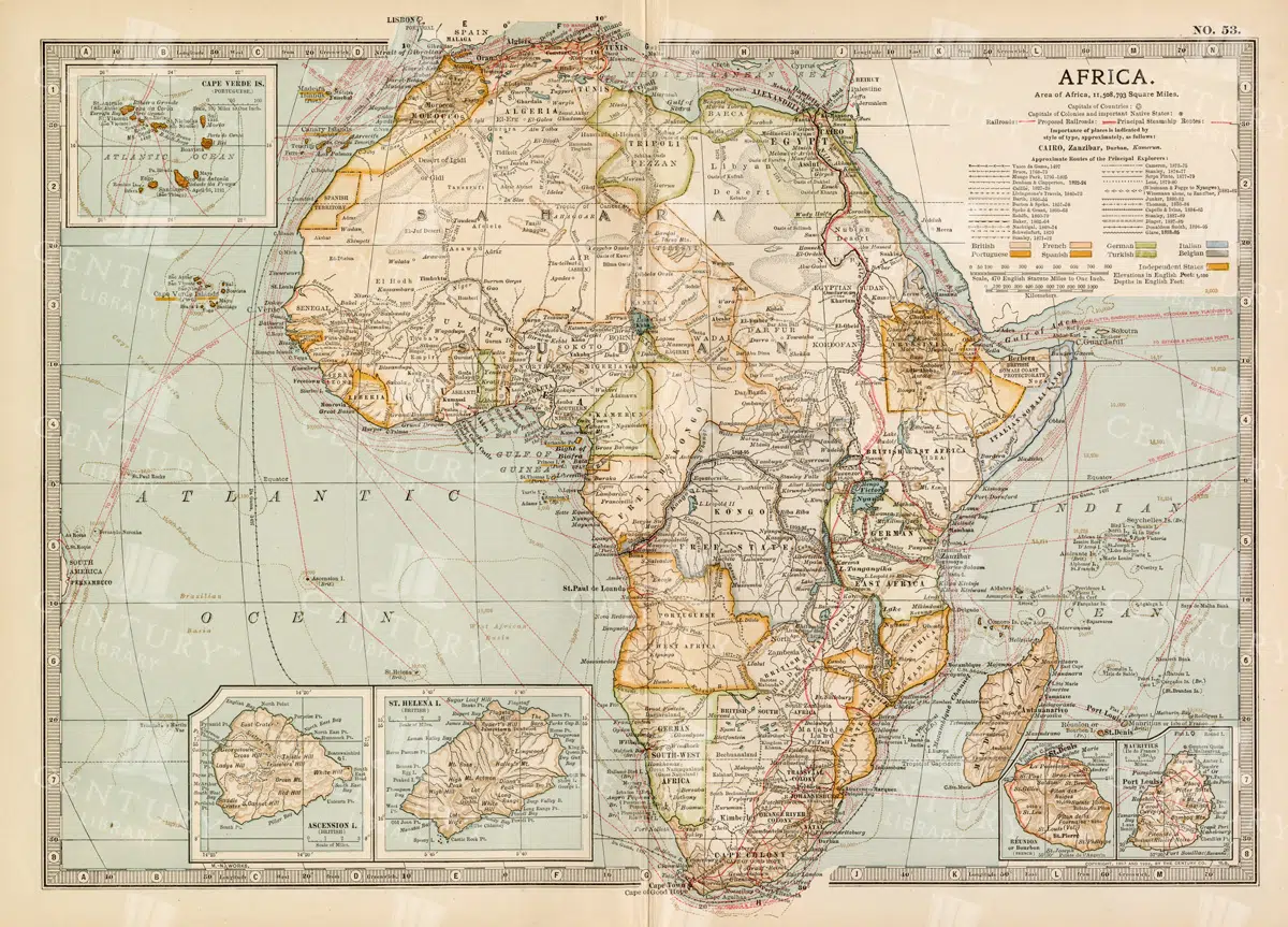
Antique 1800s Map of Africa Showing Entire Continent and Colonial Territories – Vintage Historical Cartography
This comprehensive antique map from the 1800s showcases the entire continent of Africa, highlighting colonial territories and geographical features. The map is a valuable historical document, offering insights into Africa's political and natural landscape during the colonial era. A beautifully detailed piece of vintage cartography.
- Resolution: 7104 x 5100
- Image Type(s): JPG
- 1800s
- Africa
- Africa colonial
- Africa history
- Africa map
- Antique
- antique map
- Atlas
- boundaries
- cartography
- colonial era
- colonial territories
- country
- detailed
- entire continent
- exploration
- Geography
- historical
- historical map
- History
- illustration
- Map
- natural features
- old map
- political map
- preserved
- representation
- retro
- topography
- vintage
- vintage map
- World
From this collection

Vintage 1800s Map of Asia with Emphasis on Siberia and Central Asia – Antique Historical Map
A vintage map from the 1800s featuring Asia, with special emphasis on Siberia and Central Asia. The antique map showcases the vast geography, political boundaries, and natural features of the region, offering a detailed view of Asia during the 19th century. Perfect for those interested in Asian history and vintage cartography.
- Resolution: 7109 x 5100
- Image Type(s): JPG
From this collection

Antique 1800s Map of North-West Africa Highlighting Morocco, Algeria, and Western Sahara – Vintage Historical Map
This antique map from the 1800s highlights North-West Africa, including Morocco, Algeria, and the Western Sahara. It captures the colonial and geographical landscape of the time, showing intricate details of the region’s political boundaries and natural features. A beautifully preserved piece of history in vintage cartography.
- Resolution: 7102 x 5100
- Image Type(s): JPG
- 1800s
- Africa
- Africa colonial
- Africa map
- Algeria
- Antique
- antique map
- Atlas
- cartography
- colonial
- colonial era
- country
- detailed
- exploration
- Geography
- Globe
- historical
- historical map
- History
- Map
- Morocco
- natural features
- Navigation
- North-West Africa
- old
- old map
- political boundaries
- preserved
- representation
- retro
- topography
- Travel
- vintage
- vintage map
- Western Sahara
- World
From this collection

Vintage 1800s Map of Southern Africa Including South Africa, Namibia, and Surrounding Territories – Antique Map
A vintage map from the 1800s depicting Southern Africa, including South Africa, Namibia, and surrounding territories. This antique map highlights the region’s colonial borders, cities, and natural features, offering a detailed view of the area during the colonial period. Perfect for history and cartography enthusiasts.
- Resolution: 7103 x 5100
- Image Type(s): JPG
From this collection
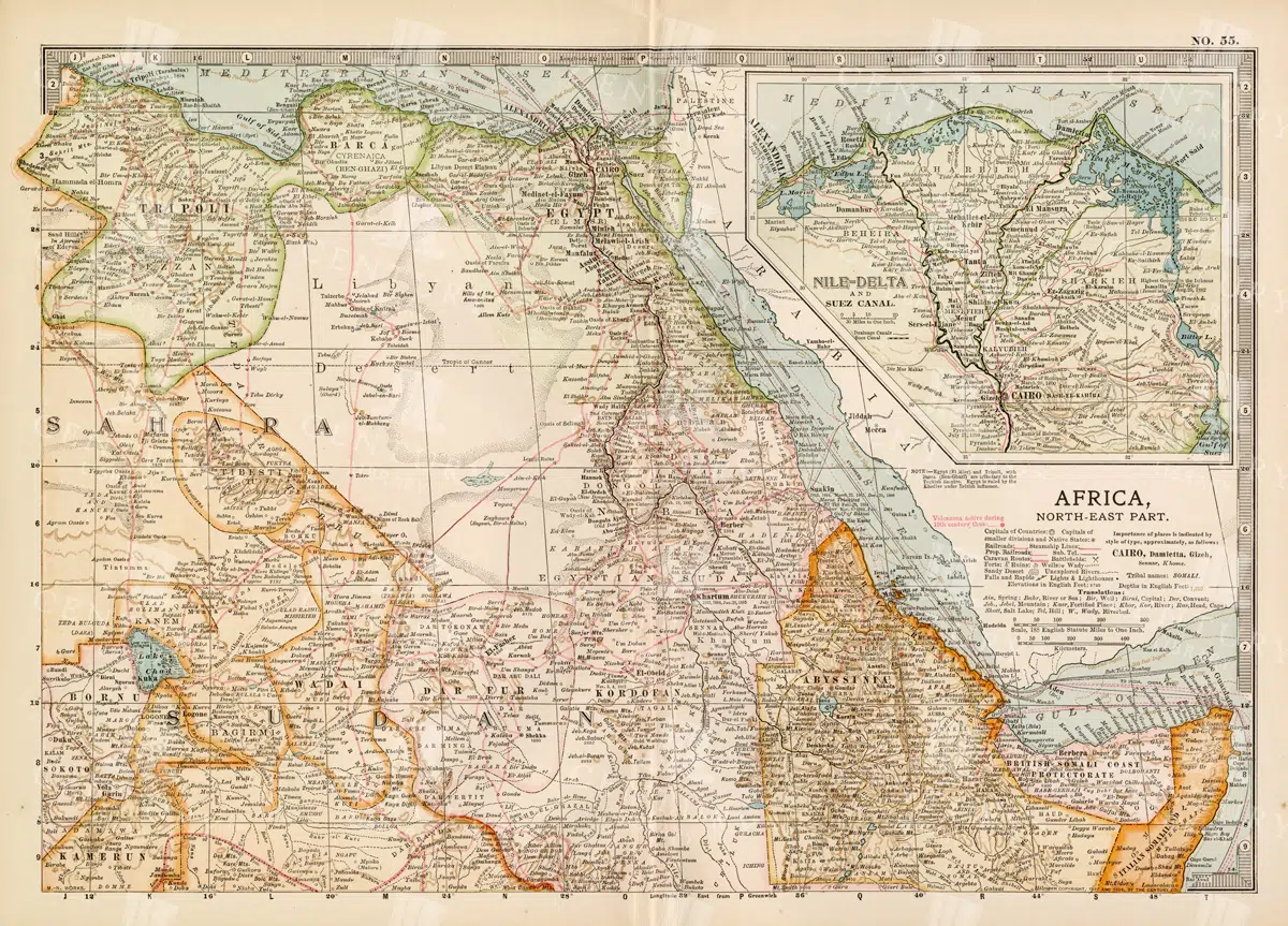
Vintage 1800s Map of North-East Africa Including Egypt, Sudan, and the Nile Delta – Antique Historical Map
This vintage map from the 1800s illustrates North-East Africa, including Egypt, Sudan, and the Nile Delta. The map is a beautiful representation of the region's historical geography, showing important cities, boundaries, and geographical features from the colonial era. A valuable piece for those interested in African history and cartography.
- Resolution: 7101 x 5100
- Image Type(s): JPG
- 1800s
- Africa
- Africa colonial
- Africa map
- Antique
- antique map
- Atlas
- boundaries
- cartography
- cities
- colonial era
- detailed
- Egypt
- exploration
- Geography
- historical
- historical geography
- historical map
- illustration
- Map
- Nile Delta
- North-East Africa
- old map
- preserved
- representation
- retro
- Rivers
- Sudan
- topography
- Travel
- vintage
- vintage map
- World
From this collection

Antique 1800s Map of Arabia, Oman, and Aden Including the Arabian Peninsula – Vintage Historical Map
This antique map from the 1800s illustrates the Arabian Peninsula, including Arabia, Oman, and Aden. The vintage map highlights the region's historical geography, boundaries, and important cities, offering a detailed view of the area during the colonial period. A valuable resource for those interested in Middle Eastern history and cartography.
- Resolution: 7106 x 5100
- Image Type(s): JPG
From this collection

Antique 1800s Map of Arkansas with Detailed County Lines and Natural Features – Vintage Historical Cartography
An antique map from the 1800s showcasing Arkansas, with detailed county lines and natural features. This vintage map provides a historical view of Arkansas’s geography during the 19th century, offering a beautifully preserved piece of the state’s cartographic history.
- Resolution: 7108 x 5100
- Image Type(s): JPG
From this collection

Vintage 1800s Map of Arizona and New Mexico Showing Territorial Boundaries and Natural Features – Antique Map
This vintage map from the 1800s depicts Arizona and New Mexico, highlighting territorial boundaries and natural features. The antique map offers a historical view of the region's geography during a formative period in its history, with intricate details of the landscape and settlements. Ideal for history buffs and map collectors.
- Resolution: 7107 x 5100
- Image Type(s): JPG
- 1800s
- American history
- American West
- Antique
- antique map
- Arizona
- Arizona map
- cartography
- colonial era
- detailed
- exploration
- Geography
- historical
- historical map
- journal
- Map
- natural features
- New Mexico
- New Mexico map
- old map
- political map
- preserved
- regional history
- representation
- retro
- territorial boundaries
- topography
- vintage
- vintage map
From this collection

Support the Library
Our supporters and members help us continue collecting and restoring these wonderful pieces of art for the modern creator
Unlock Everything and Become a Member!
While a lot of the library is available for free, some is kept behind closed dusty doors only to be accessed by our lovely members.