

Globe and Clouds Vector Lineart Illustrations – Vintage World and Cloud Clip Art – PNG, SVG, and EPS Vector Formats Included!
You're looking at a unique set of globe and cloud illustrations discovered in a late 1800s design book. These illustrations were extracted from their original backgrounds and converted to the following image formats: SVG (vector), EPS (vector), and, of course, PNG (300dpi raster image with transparent background).
- Image Type(s): EPS, SVG, PNG
Related Images


19th Century World Map – Chief Countries and Their Colonies
An antique world map from the 19th century showcasing chief countries and their colonies during the period. The map uses Mercator's projection and highlights the global political landscape, including colonial possessions.
- Resolution: 7272 x 5100
- Image Type(s): JPG
From this collection
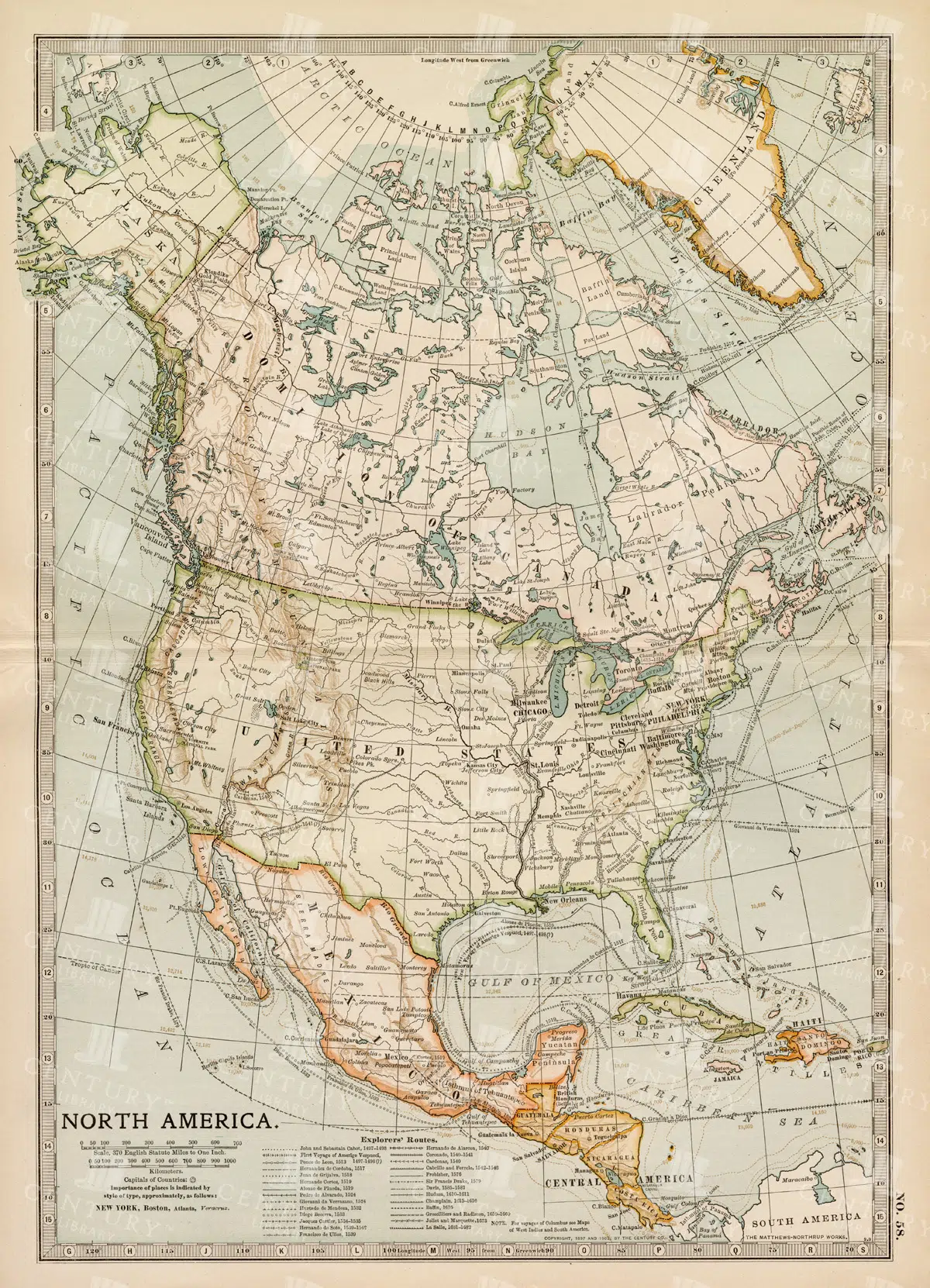
Vintage Map of North America
A historic map of North America, offering a comprehensive view of the continent's geography, including the United States, Canada, and Mexico, from the late 19th century.
- Resolution: 7242 x 5100
- Image Type(s): JPG
From this collection

1897 Map of Italy: Comprehensive View Including Rome and Venice
A detailed 1897 map of Italy, encompassing the entire peninsula including key cities like Rome and Venice. This map highlights the topographical features, transportation networks, and regional boundaries of Italy during the late 19th century. It offers a broad view of Italy's geography and historical development, making it a significant resource for historical studies.
- Resolution: 7153 x 5100
- Image Type(s): JPG
From this collection

Vintage Map of Europe Showing Key Regions and Countries
This vintage map of Europe provides a detailed view of the continent’s countries, regions, and geographical features. The map offers a historical perspective on Europe’s political boundaries and major cities during the time period. Its detailed cartography and vintage aesthetic make it a valuable resource for historians, collectors, and anyone interested in European history. The map includes insets of various regions, adding further detail and context.
- Resolution: 7131 x 5100
- Image Type(s): JPG
- antique europe
- antique map
- Atlas
- countries
- country
- detailed europe map
- detailed map
- Europe
- europe cartography
- europe countries
- europe geography
- europe map
- europe map vintage
- europe regions
- europe vintage
- european cartography
- european cities
- european geography
- european history
- european regions
- Geography
- historical
- historical europe
- historical geography
- historical map
- Map
- old europe map
- old european map
- old map
- regions
- representation
- Travel
- vintage
- vintage cartography
- vintage europe
- World
From this collection

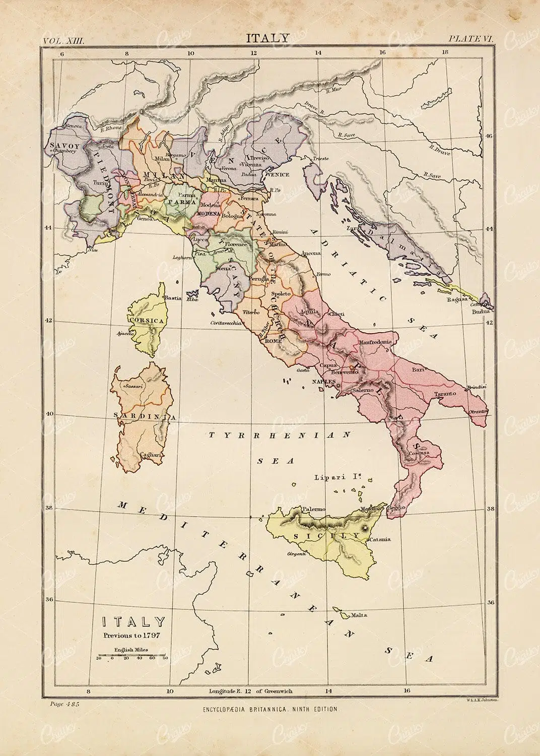
Vintage Map of Italy – Encyclopedia Britannica 1880
- License Info
- Resolution: 6938px x 9452px
- Year of Print: 1880
- Artist: Encyclopedia Britannica
From this collection

1880 Encyclopedia Britannica Vintage Botany Print
- License Info
- Resolution: 6841px x 9579px
- Year of Print: 1880
- Artist: Encyclopedia Britannica
From this collection

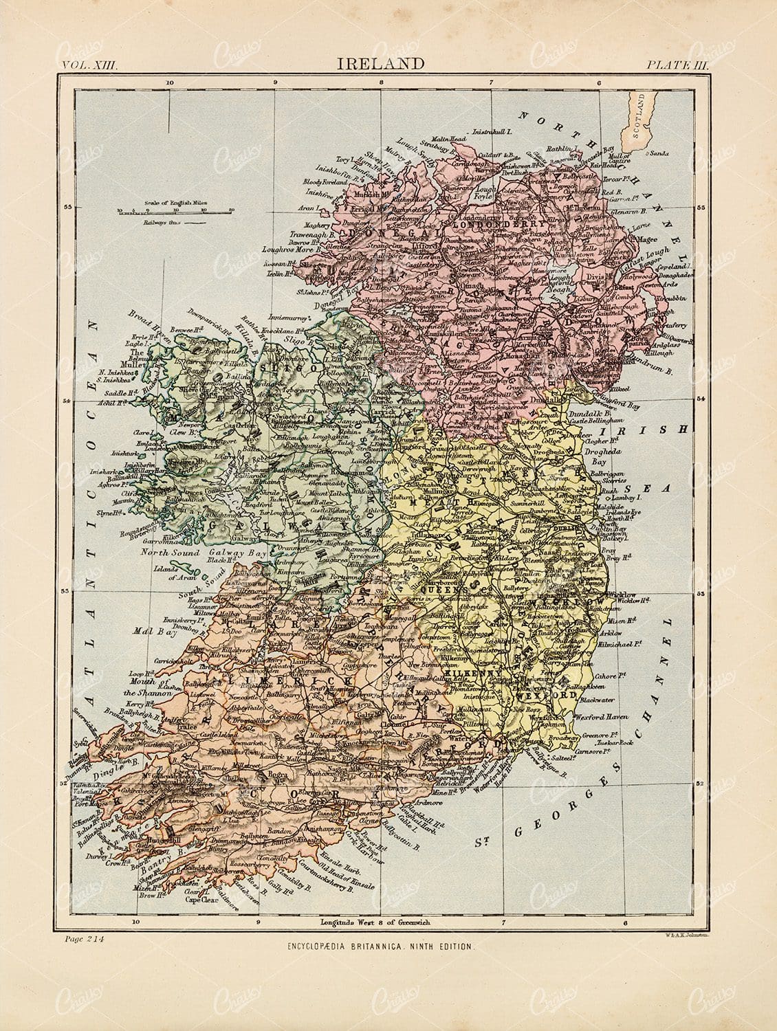
Vintage Map of Ireland Highlighting Political Boundaries and Topographical Features
This vintage map of Ireland highlights the country's political boundaries and key topographical features, including rivers, mountains, and major cities. The map provides a historical overview of Ireland during the late 19th century, offering insight into the geopolitical landscape and cultural heritage of the island. It includes detailed insets of Dublin and its surrounding areas, reflecting Ireland's rich history and complex political past.
- Resolution: 7149 x 5100
- Image Type(s): JPG
- late 19th century
- geopolitical
- Irish history
- Ireland history
- cultural heritage
- topography
- cities
- historical geography
- antique map
- historical map
- exploration
- old map
- cartography
- political boundaries
- Dublin
- vintage
- representation
- Antique
- History
- Island
- Geography
- Atlas
- World
- Landscape
- Ireland
- Rivers
- Mountains
- Map
- United Kingdom
- Europe
From this collection

Vintage Map of Italy – Encyclopedia Britannica 1880
- License Info
- Resolution: 7324px x 9646px
- Year of Print: 1880
- Artist: Encyclopedia Britannica
From this collection
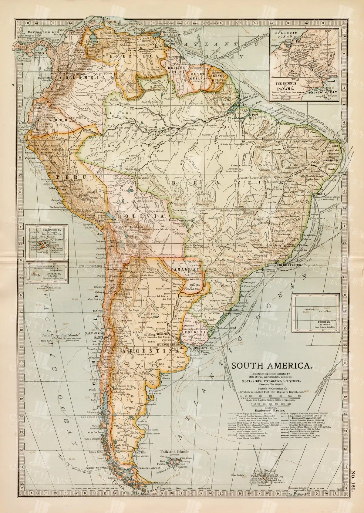
Complete 19th Century Map of South America with Geographical Details
A comprehensive 19th century map of South America, illustrating the continent's countries, cities, and geographical features in great detail. This vintage map provides an overview of the political landscape and natural features of the era.
- Resolution: 7262 x 5100
- Image Type(s): JPG
- 1800s
- 19th-century
- antique cartography
- antique map
- antique paper
- archival
- Atlas
- cartographic history
- cartography
- cities
- complete map
- geographical features
- Geography
- heritage
- historical artifact
- historical document
- historical geography
- historical information
- historical map
- historical records
- history lovers
- Latin America
- Map
- map of South America
- old map
- old South America
- political divisions
- representation
- South America
- South American history
- topography
- vintage
- vintage map
- World
From this collection
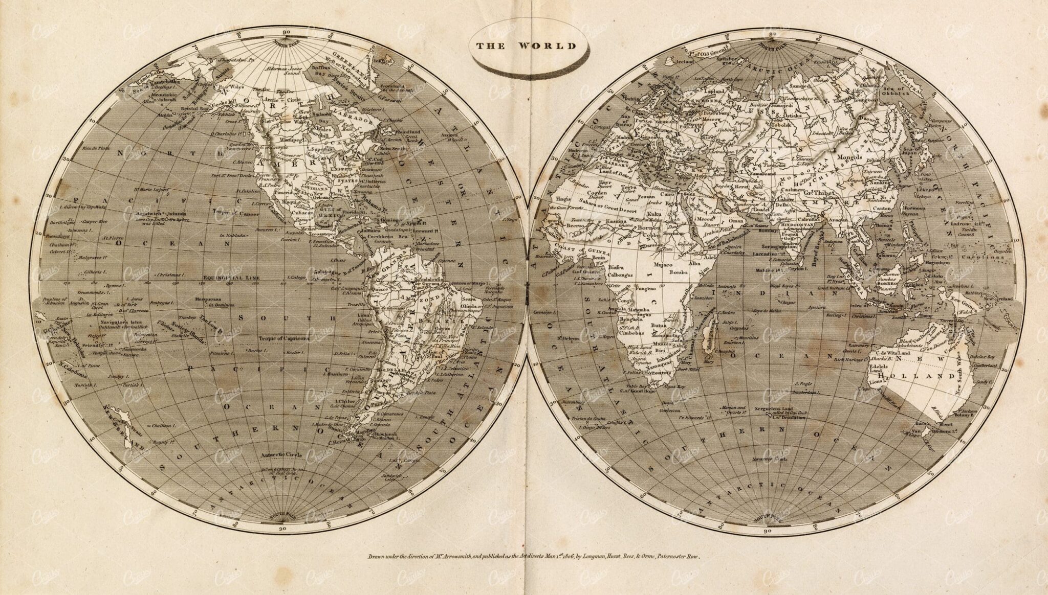
ANTIQUE Map of The World – Rees’ Encyclopedia 1800s
- License Info
- Resolution: 14829px x 8428px
- Year of Print: 1800s
- Artist: Abraham Rees
From this collection
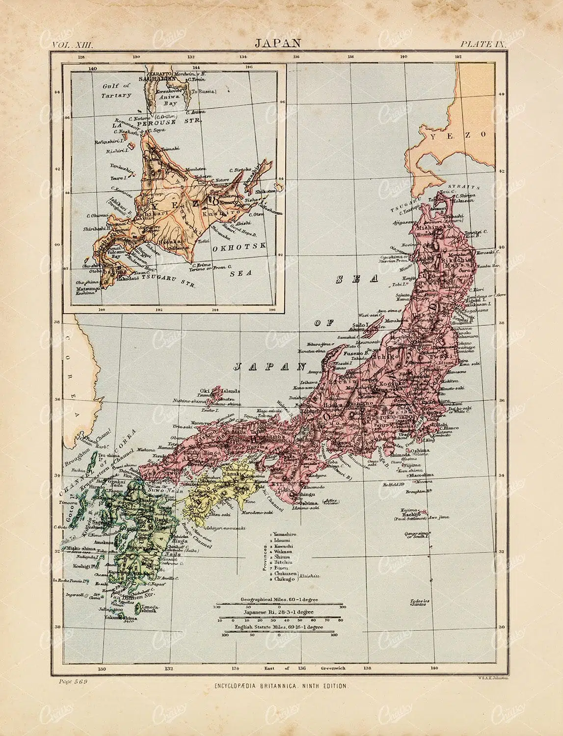
Antique Map of Japan – 1880 Encyclopedia Britannica
- License Info
- Resolution: 7359px x 9623px
- Year of Print: 1880
- Artist: Encyclopedia Britannica
From this collection
Vintage Map of Italy – Encyclopedia Britannica 1880
- License Info
- Resolution: 6890px x 9639px
- Year of Print: 1880
- Artist: Encyclopedia Britannica
From this collection

Antique Map of Florida Highlighting Key Regions and Coastal Areas
This antique map of Florida offers a detailed view of the state’s counties, cities, and coastal regions. The map provides historical insight into Florida’s geography, showcasing key areas such as Jacksonville, Tampa, and Miami. The insets offer additional detail, making this map a valuable resource for collectors and history enthusiasts. Its vintage style and detailed cartography add to its charm and historical significance.
- Resolution: 7132 x 5100
- Image Type(s): JPG
- Antique
- antique geography
- antique map
- Atlas
- cities
- coastal map
- collectible map
- counties
- detailed florida map
- detailed map
- Florida
- florida cartography
- florida coastal map
- florida geography
- florida historical map
- florida history
- florida map
- florida regions
- florida towns
- florida vintage
- Geography
- historical florida map
- historical geography
- historical map
- jacksonville
- Map
- miami
- old florida map
- old map
- regions
- representation
- southern florida
- southern states
- tampa
- vintage
- vintage cartography
- vintage florida
- World
From this collection
Encyclopedia Britannica 1880 – Vintage Map of Ireland
- License Info
- Resolution: 7244px x 9615px
- Year of Print: 1880
- Artist: Encyclopedia Britannica
From this collection

Antique 1880 Print – Vintage Map of Mexico
- License Info
- Resolution: 13544px x 9426px
- Year of Print: 1880
- Artist: Encyclopedia Britannica
From this collection

Detailed 19th Century Map of the Netherlands, Belgium, and Luxembourg
A detailed antique map from the 19th century featuring the Netherlands, Belgium, and Luxembourg. The map showcases the geographical and political landscape of the region, including major cities, rivers, and borders.
- Resolution: 7271 x 5100
- Image Type(s): JPG
From this collection
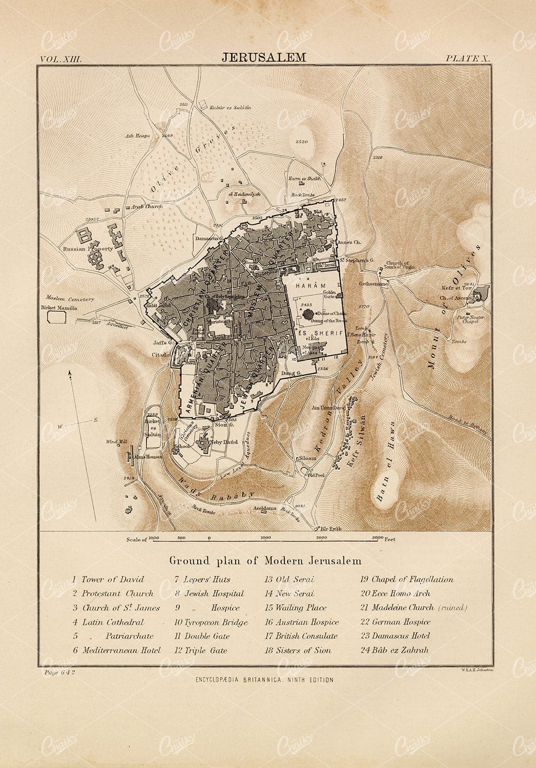
Ground Plan of Modern Jerusalem – 1880 Vintage Print
- License Info
- Resolution: 6675px x 9574px
- Year of Print: 1880
- Artist: Encyclopedia Britannica
From this collection
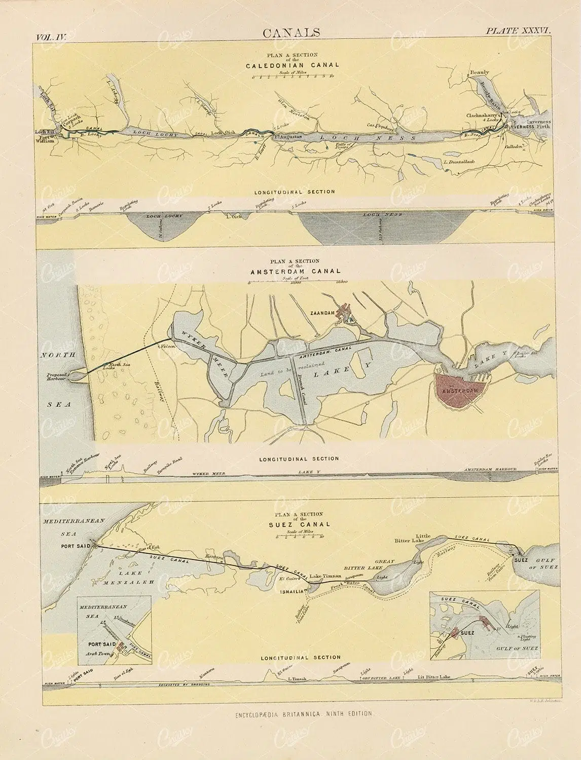
Vintage Print of Various Canals – 1880 Encyclopedia Britannica
- License Info
- Resolution: 7302px x 9558px
- Year of Print: 1880
- Artist: Encyclopedia Britannica
From this collection
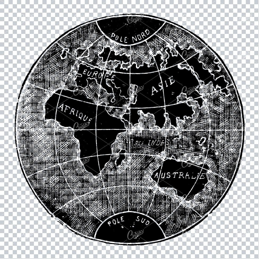
Small Vintage Illustration of the World / Globe Map
- License Info
- Resolution: 1805px x 1780px
Related Images

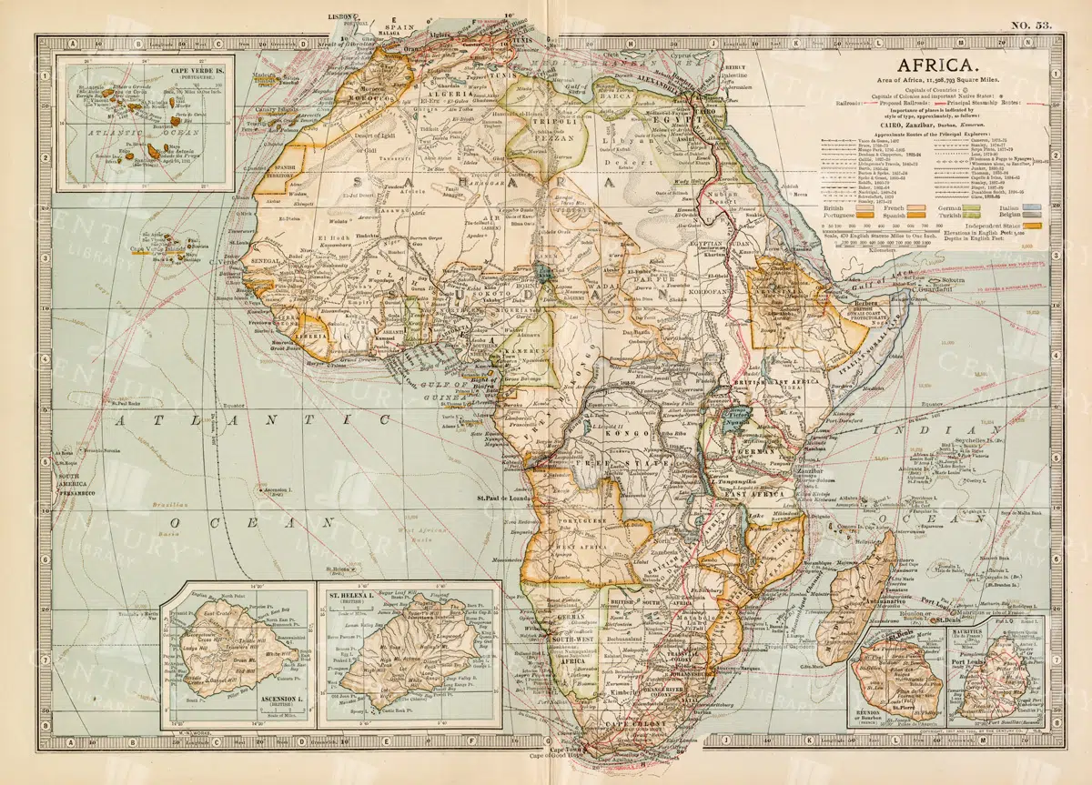
Antique 1800s Map of Africa Showing Entire Continent and Colonial Territories – Vintage Historical Cartography
This comprehensive antique map from the 1800s showcases the entire continent of Africa, highlighting colonial territories and geographical features. The map is a valuable historical document, offering insights into Africa's political and natural landscape during the colonial era. A beautifully detailed piece of vintage cartography.
- Resolution: 7104 x 5100
- Image Type(s): JPG
- 1800s
- Africa
- Africa colonial
- Africa history
- Africa map
- Antique
- antique map
- Atlas
- boundaries
- cartography
- colonial era
- colonial territories
- country
- detailed
- entire continent
- exploration
- Geography
- historical
- historical map
- History
- illustration
- Map
- natural features
- old map
- political map
- preserved
- representation
- retro
- topography
- vintage
- vintage map
- World
From this collection
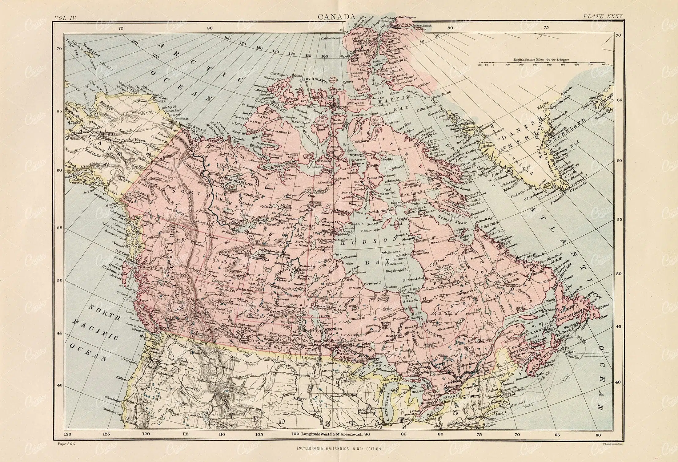
Vintage Map of Canada – 1880 Encyclopedia Britannica
- License Info
- Resolution: 13853px x 9433px
- Year of Print: 1880
- Artist: Encyclopedia Britannica
From this collection
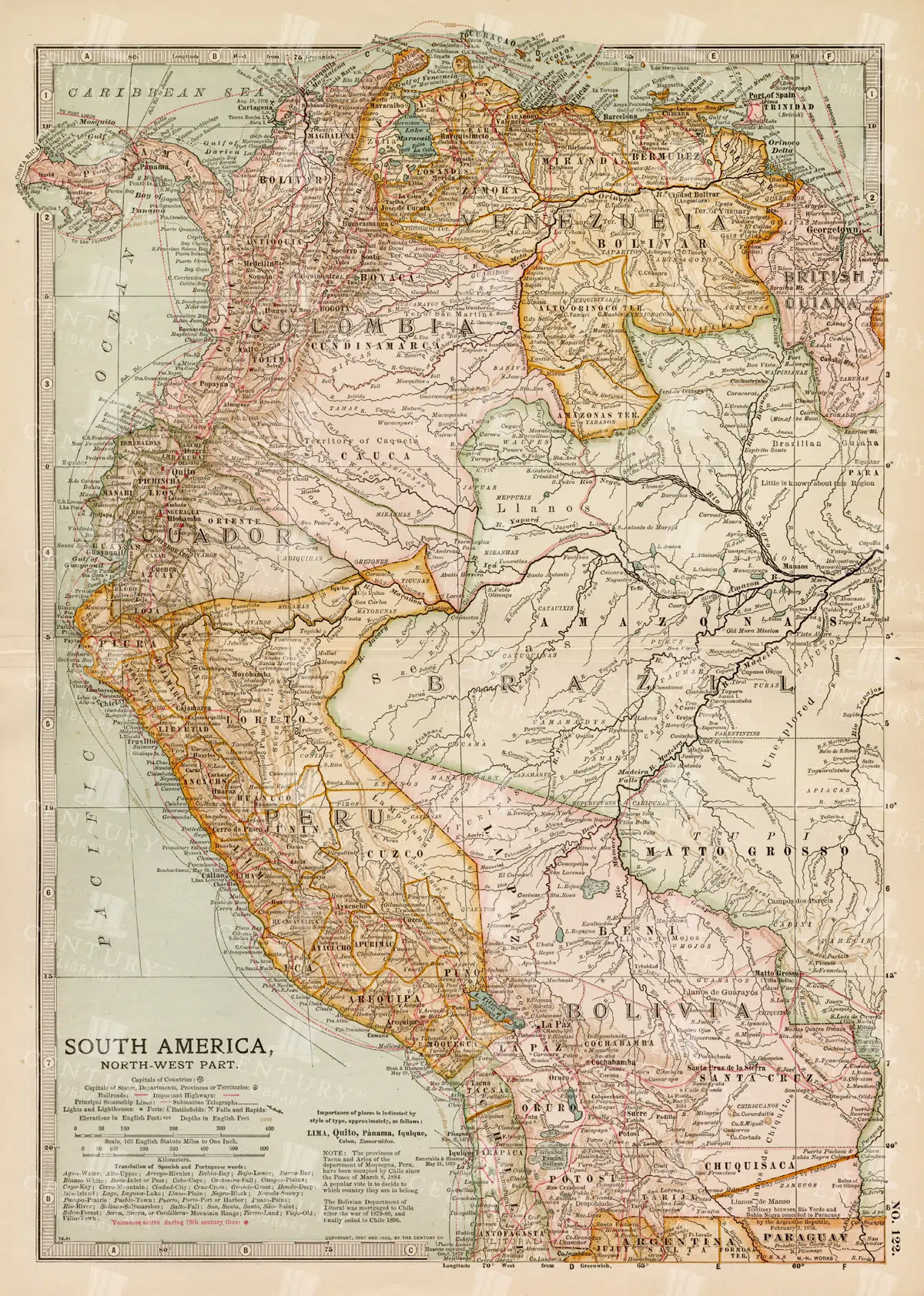
Detailed 19th Century Map of Northwestern South America
A detailed 19th century map illustrating the northwestern part of South America, including countries like Colombia, Venezuela, and Ecuador. This vintage map offers a glimpse into the political and geographical divisions of the era, with detailed insets of major cities and regions.
- Resolution: 7260 x 5100
- Image Type(s): JPG
- 1800s
- 19th-century
- Antique
- antique cartography
- antique map
- antique paper
- archival
- Atlas
- cartographic history
- cartography
- cities
- Colombia
- country
- Ecuador
- geographical features
- Geography
- Globe
- heritage
- historical artifact
- historical document
- historical geography
- historical information
- historical map
- historical records
- history lovers
- Latin America
- Map
- map of Colombia
- Navigation
- Northwestern South America
- old map
- old South America
- political divisions
- representation
- South America
- South American history
- topography
- Travel
- Venezuela
- vintage
- vintage map
- World
From this collection

Antique 19th Century Map of Norway and Sweden with Topographical Details
A beautifully detailed antique map from the 19th century showcasing the countries of Norway and Sweden, with topographical features, major cities, and inset maps of Kristiana and Stockholm.
- Resolution: 7245 x 5100
- Image Type(s): JPG
From this collection
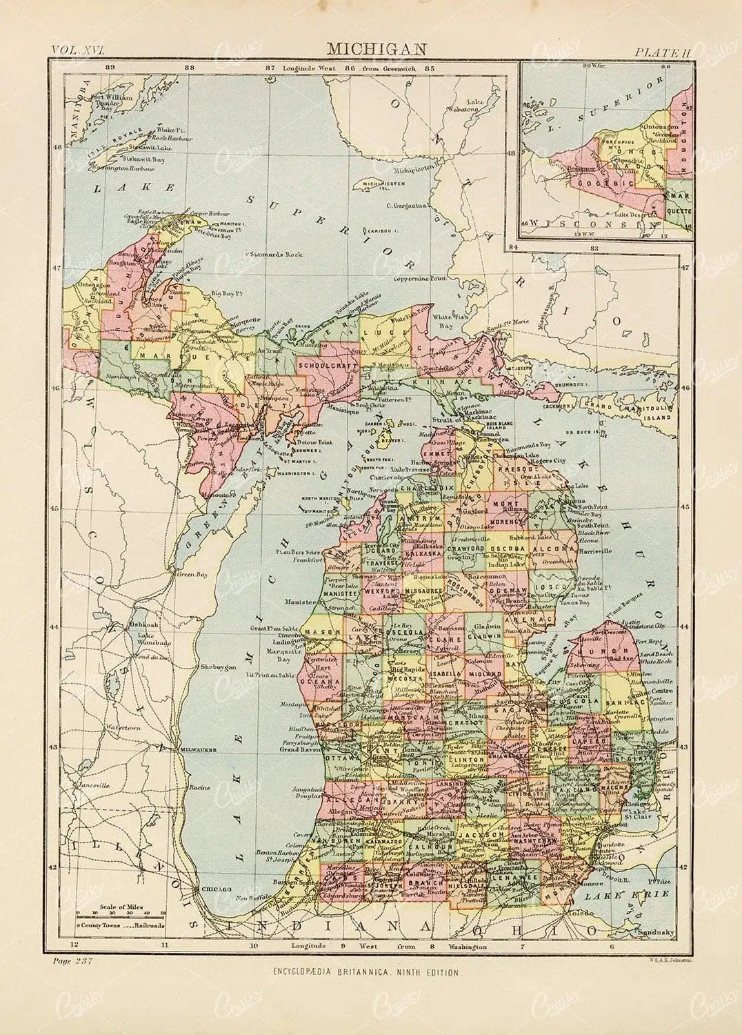
1880 Vintage Map of Michigan – Encyclopedia Britannica
- License Info
- Resolution: 6864px x 9573px
- Year of Print: 1880
- Artist: Encyclopedia Britannica
From this collection

Vintage Map of Southern England and Wales Highlighting Major Cities and Coastal Areas
This vintage map of Southern England and Wales highlights major cities, coastal areas, and important transportation routes. The map provides detailed insights into the region's historical geography and urban development during the period.
- Resolution: 7127 x 5100
- Image Type(s): JPG
From this collection

Antique Map of Brazil – 1880 Encyclopedia Britannica
- License Info
- Resolution: 7007px x 9539px
- Year of Print: 1880
- Artist: Encyclopedia Britannica
From this collection

Antique Map of the West Indies
Historical antique map of the West Indies, showcasing islands like Cuba, Jamaica, and Puerto Rico, with detailed nautical routes, ports, and topography. Includes inset of Bermuda. 19th century cartography.
- Resolution: 7279 x 5100
- Image Type(s): JPG
- 19th-century
- Antique
- archival
- Atlantic Ocean
- Atlas
- bermuda
- bermuda map
- Caribbean
- Caribbean islands
- cartographer
- cartography
- classic
- collectible
- country
- cuba
- detailed map
- exploration
- Geography
- heritage
- historical
- historical map
- History
- island history
- Islands
- islands map
- Jamaica
- Map
- maritime
- Nautical
- nautical routes
- nostalgic
- old map
- ports
- puerto rico
- representation
- sea routes
- topography
- transportation
- vintage
- West Indies
- west indies map
- World
From this collection

Antique Map of Northern France Including the English Channel and Paris
This antique map of Northern France illustrates the region’s towns, roads, and geographical features, including Paris and the English Channel. The map provides a detailed representation of the historical geography of the area, showing the connections between key locations. Its vintage aesthetic adds charm, making it a must-have for history enthusiasts and map collectors. Insets highlight additional regions, enhancing the map's utility and appeal.
- Resolution: 7134 x 5100
- Image Type(s): JPG
- antique map
- Atlas
- detailed map
- english channel
- english channel map
- France
- france cartography
- france history
- france regions
- france towns
- france vintage
- french cartography
- french geography
- french history
- french map
- Geography
- historical
- historical france map
- historical geography
- historical map
- Map
- northern
- northern france
- old france map
- old map
- Paris
- paris geography
- paris map
- representation
- Roads
- towns
- vintage
- vintage cartography
- vintage france
- World
From this collection

VINTAGE Print of a Star Map of the Southern Sky – Antique 1882
- License Info
- Resolution: 8207px x 8732px
- Year of Print: 1882
Related Images

New Guinea and New Caledonia Vintage Map 1880
- License Info
- Resolution: 9489px x 7333px
- Year of Print: 1880
- Artist: Encyclopedia Britannica
From this collection

Central Europe Travel Map Featuring Major Cities Like Paris, Berlin, and Vienna
This travel map of Central Europe highlights major cities such as Paris, Berlin, and Vienna, showcasing detailed routes and geographical features. The map provides a glimpse into the historical and political landscape of Central Europe during the time.
- Resolution: 7117 x 5100
- Image Type(s): JPG
From this collection

19th Century Map of Spain, Portugal, and Andorra
An antique map from the 19th century detailing the countries of Spain, Portugal, and Andorra, along with surrounding regions. The map features important cities, mountain ranges, and bodies of water, offering a glimpse into the historical geography of the Iberian Peninsula.
- Resolution: 7266 x 5100
- Image Type(s): JPG
- 19th-century
- Andorra
- Antique
- archives
- Atlantic
- Atlas
- Borders
- cartography
- cities
- country
- Europe
- exploration
- Geography
- heritage
- historic map
- historical
- History
- Iberian Peninsula
- landmarks
- Landscape
- Map
- Mediterranean
- Mountains
- old map
- Portugal
- Pyrenees
- reference
- representation
- retro
- Rivers
- settlements
- Spain
- topographic
- vintage
- vintage map
- World
From this collection

19th Century Map of Southern South America Featuring Argentina and Chile
A richly detailed 19th century map of Southern South America, highlighting countries like Argentina and Chile, with special insets of Buenos Aires, Montevideo, and Valparaiso. This vintage map showcases the region's political and geographical landscape during the era.
- Resolution: 7261 x 5100
- Image Type(s): JPG
- 1800s
- 19th-century
- antique cartography
- antique map
- antique paper
- archival
- Argentina
- Atlas
- Buenos Aires
- cartographic history
- cartography
- Chile
- cities
- geographical features
- Geography
- heritage
- historical artifact
- historical document
- historical geography
- historical information
- historical map
- historical records
- history lovers
- Latin America
- Map
- map of Argentina
- Montevideo
- old map
- old South America
- political divisions
- representation
- South America
- South American history
- Southern South America
- topography
- Valparaiso
- vintage
- vintage map
- World
From this collection

Detailed Historical Map of the East India Islands Including Malaysia and the Philippines
A detailed historical map of the East India Islands, including regions like Malaysia, the Philippines, and New Guinea. The map highlights important geographical features, cities, and maritime routes, offering a glimpse into the region's colonial history.
- Resolution: 7123 x 5100
- Image Type(s): JPG
From this collection

Antique Map of the Mohammedan Empire – 1880
- License Info
- Resolution: 9499px x 7247px
- Year of Print: 1880
- Artist: Encyclopedia Britannica
From this collection

1880 Vintage Print – Antique Map of Oregon & Washington
- License Info
- Resolution: 7207px x 9581px
- Year of Print: 1880
- Artist: Encyclopedia Britannica
From this collection
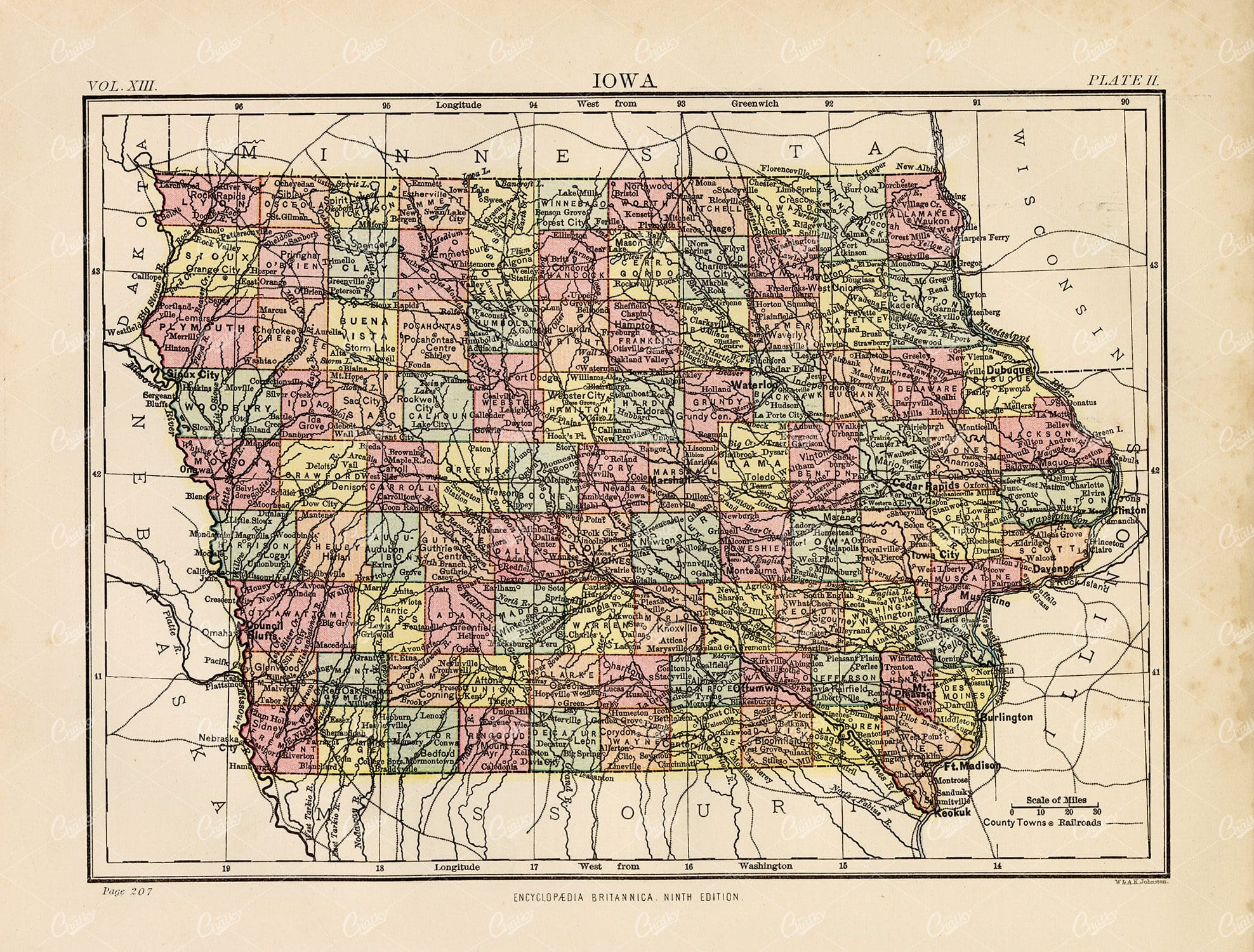
Vintage Print 1880 – Antique Map of Iowa
- License Info
- Resolution: 9570px x 7265px
- Year of Print: 1880
- Artist: Encyclopedia Britannica
From this collection

1880 Encyclopedia Britannica – Antique Map of Mississippi
- License Info
- Resolution: 7008px x 9584px
- Year of Print: 1880
- Artist: Encyclopedia Britannica
From this collection
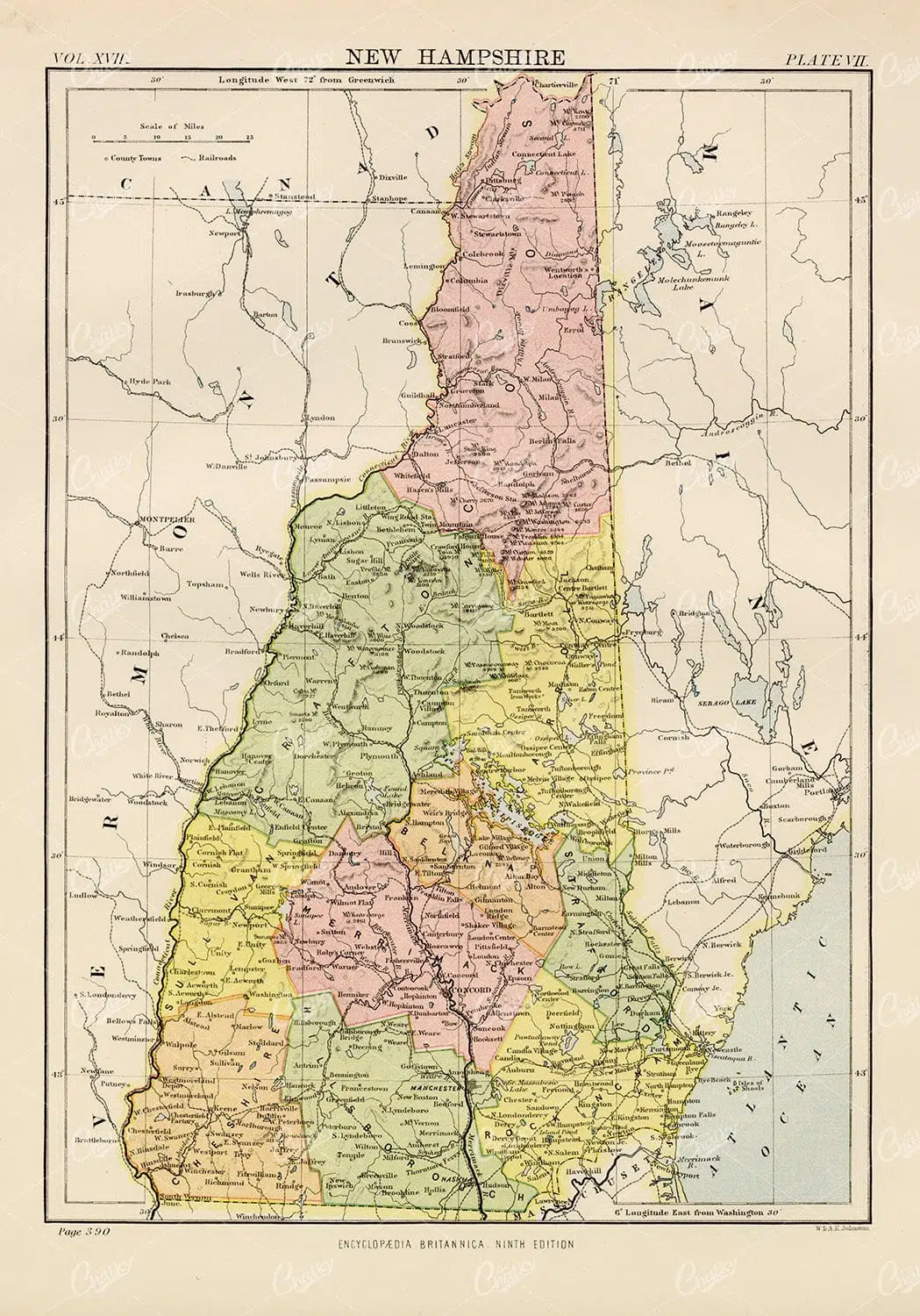
Encyclopedia Britannica 1880 – Vintage Map of New Hampshire
- License Info
- Resolution: 6693px x 9568px
- Year of Print: 1880
- Artist: Encyclopedia Britannica
From this collection

Antique Map of Philippine Islands and Hawaiian Islands with Inset Maps
A detailed 19th-century map showcasing the Philippine Islands and Hawaiian Islands, complete with inset maps of major cities like Manila and Honolulu. This map is ideal for historical and geographical research.
- Resolution: 7254 x 5100
- Image Type(s): JPG
From this collection
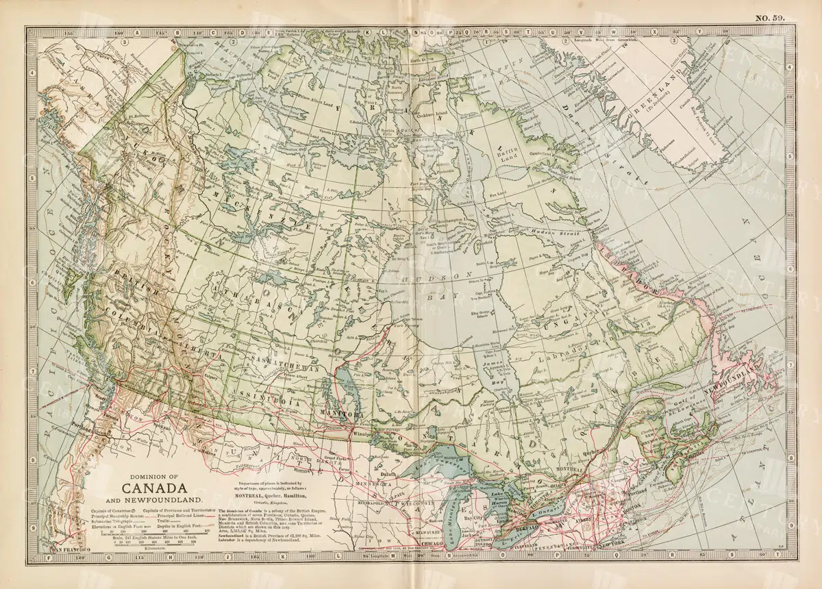
Antique Map of Canada and Newfoundland Highlighting Major Cities and Natural Features
An antique map of Canada and Newfoundland, offering a detailed look at the region's cities, natural landmarks, and geographical features. The map provides insights into the historical significance of the area during the time of its creation.
- Resolution: 7115 x 5100
- Image Type(s): JPG
From this collection
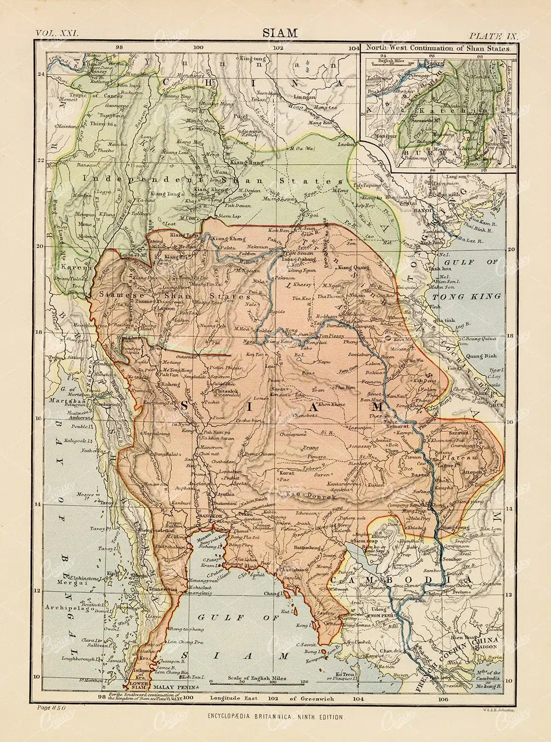
Antique Map of Siam – 1880 Encyclopedia Britannica
- License Info
- Resolution: 7016px x 9455px
- Year of Print: 1880
- Artist: Encyclopedia Britannica
From this collection
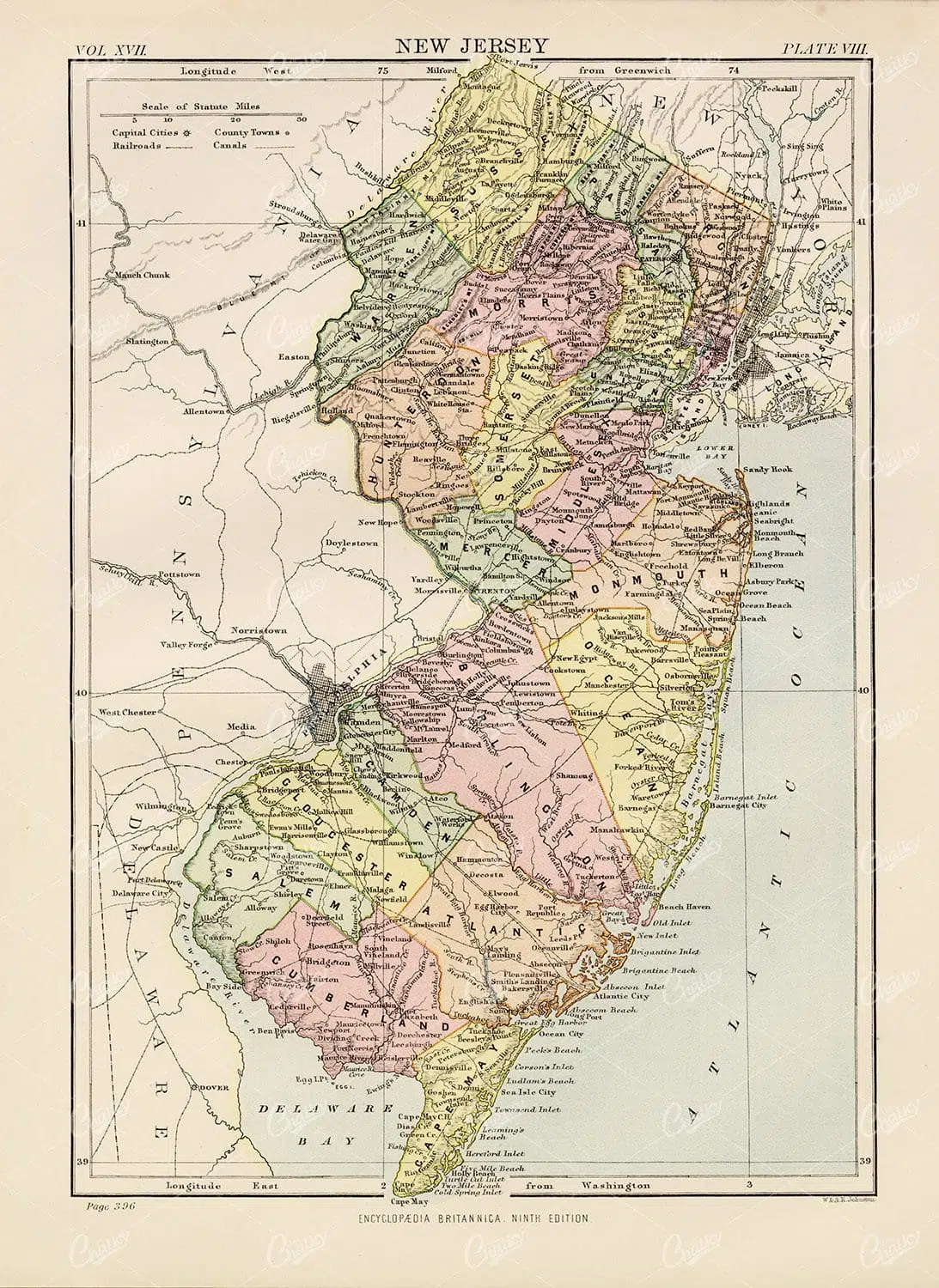
Encyclopedia Britannica 1880 – New Jersey Vintage Map
- License Info
- Resolution: 6996px x 9597px
- Year of Print: 1880
- Artist: Encyclopedia Britannica
From this collection

Antique Map of Missouri – Encyclopedia Britannica 1880
- License Info
- Resolution: 9571px x 7359px
- Year of Print: 1880
- Artist: Encyclopedia Britannica
From this collection

Vintage 1880 Print – Map of Minnesota
- License Info
- Resolution: 6920px x 9572px
- Year of Print: 1880
- Artist: Encyclopedia Britannica
From this collection

Vintage Map of Nebraska – Encyclopedia Britannica 1880
- License Info
- Resolution: 9549px x 7362px
- Year of Print: 1880
- Artist: Encyclopedia Britannica
From this collection
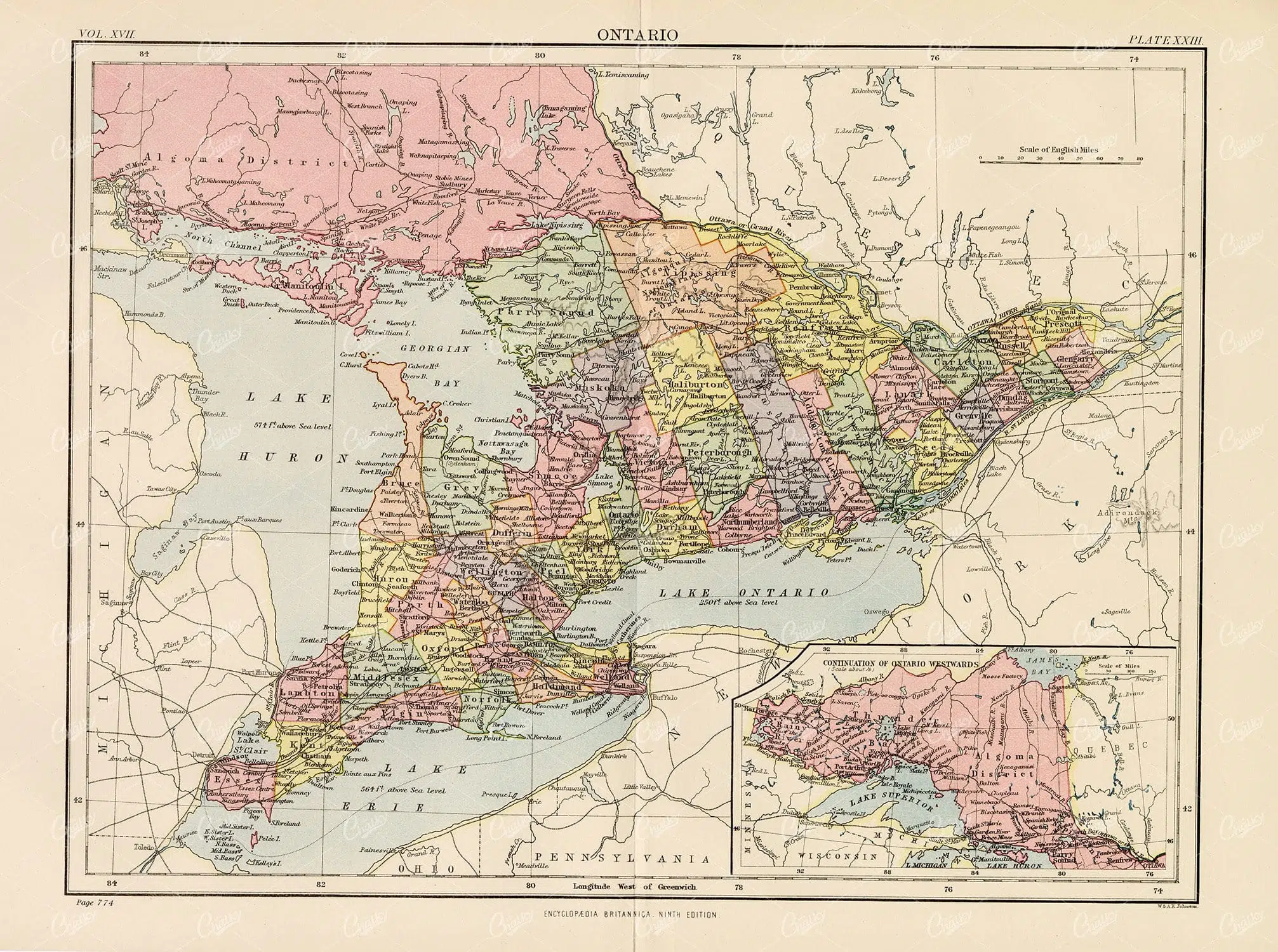
Encyclopedia Britannica 1880 – Vintage Map of Ontario
- License Info
- Resolution: 12700px x 9463px
- Year of Print: 1880
- Artist: Encyclopedia Britannica
From this collection

19th Century Central Scotland Map Featuring Glasgow and Edinburgh
A vintage map from the 19th century depicting central Scotland, highlighting major cities like Glasgow and Edinburgh. This historical map is rich in detail, showcasing the region's topography, transportation routes, and geographical features during the era.
- Resolution: 7258 x 5100
- Image Type(s): JPG
- 1800s
- 19th-century
- antique cartography
- antique map
- antique paper
- archival
- Atlas
- British History
- cartographic history
- cartography
- central Scotland
- cities
- Edinburgh
- geographical features
- Geography
- Glasgow
- heritage
- historical artifact
- historical document
- historical geography
- historical information
- historical map
- historical records
- history lovers
- Lowlands
- Map
- map of Scotland
- old Britain
- old map
- representation
- Scotland
- Scottish Highlands
- Scottish history
- topography
- transportation routes
- United Kingdom
- vintage
- vintage map
- World
From this collection

Antique 1800s Map of North-West Africa Highlighting Morocco, Algeria, and Western Sahara – Vintage Historical Map
This antique map from the 1800s highlights North-West Africa, including Morocco, Algeria, and the Western Sahara. It captures the colonial and geographical landscape of the time, showing intricate details of the region’s political boundaries and natural features. A beautifully preserved piece of history in vintage cartography.
- Resolution: 7102 x 5100
- Image Type(s): JPG
- 1800s
- Africa
- Africa colonial
- Africa map
- Algeria
- Antique
- antique map
- Atlas
- cartography
- colonial
- colonial era
- country
- detailed
- exploration
- Geography
- Globe
- historical
- historical map
- History
- Map
- Morocco
- natural features
- Navigation
- North-West Africa
- old
- old map
- political boundaries
- preserved
- representation
- retro
- topography
- Travel
- vintage
- vintage map
- Western Sahara
- World
From this collection

Support the Library
Our supporters and members help us continue collecting and restoring these wonderful pieces of art for the modern creator
Unlock Everything and Become a Member!
While a lot of the library is available for free, some is kept behind closed dusty doors only to be accessed by our lovely members.