

ANTIQUE Elizabethan No 2 Owen Jones Original Print – Vintage 1865
- License Info
- Resolution: 7478px x 11709px
- Year of Print: 1865
- Artist: Owen Jones
From this collection
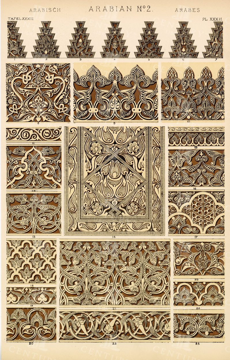
ANTIQUE Decorative Print – ARABIAN No 2 – Original Vintage 1865
- License Info
- Resolution: 7473px x 11701px
- Year of Print: 1865
- Artist: Owen Jones
Related Images

ANTIQUE Furniture – Court Cupboard Buffet – Old 1910 Lithograph Print
You're looking at a perfectly preserved lithographed illustration from the Book of Decorative Furniture, its Form, Colour, & History by Edwin Foley of the institute of designers. The original series documented a wide variety of British Woodwork styles and contemporaries, decorative furnishings, accessories and more. Entirely illustrated by Foley himself.
- License Info
- Resolution: 6653 x 8328 300dpi
- Year of Print: 1910
- Artist: Edwin Foley
Related Images

VINTAGE Decorative Interior Design – Rare 19th Century Print
- License Info
- Resolution: 10977px x 15480px
- Year of Print: 1866
- Artist: Michel Lienard
From this collection


1843 Vintage Map of Ireland – Antique Illustration by Mr and Mrs S. C. Hall
- Resolution: 8501px x 5561px
- Year of Print: 1843
- Artist: MR & MRS. S. C. HALL
Related Images

VINTAGE Map of Mayo, Ireland – 1843 Antique Illustration
- Resolution: 8530px x 5561px
- Year of Print: 1843
- Artist: MR & MRS. S. C. HALL
Related Images

ANTIQUE Map of Europe – Original Vintage 1836 Print
- License Info
- Resolution: 8398px x 7296px
- Year of Print: 1836
- Artist: Charles Taylor
Related Images

MEDIEVAL Decorative Furniture – Carved Oak Dressoir – Louis XII
You're looking at a perfectly preserved lithographed illustration from the Book of Decorative Furniture, its Form, Colour, & History by Edwin Foley of the institute of designers. The original series documented a wide variety of British Woodwork styles and contemporaries, decorative furnishings, accessories and more. Entirely illustrated by Foley himself.
- License Info
- Resolution: 6143 x 8310 300dpi
- Year of Print: 1910
- Artist: Edwin Foley
Related Images

ANTIQUE Furniture Print – Carved, Inlaid Oak Court Cupboard – Edwin Foley
You're looking at a perfectly preserved lithographed illustration from the Book of Decorative Furniture, its Form, Colour, & History by Edwin Foley of the institute of designers. The original series documented a wide variety of British Woodwork styles and contemporaries, decorative furnishings, accessories and more. Entirely illustrated by Foley himself.
- License Info
- Resolution: 6851 x 8384 300dpi
- Year of Print: 1910
- Artist: Edwin Foley
Related Images

ANTIQUE Furniture Print – Carved Bourgouignon Credence – Edwin Foley 1910
You're looking at a perfectly preserved lithographed illustration from the Book of Decorative Furniture, its Form, Colour, & History by Edwin Foley of the institute of designers. The original series documented a wide variety of British Woodwork styles and contemporaries, decorative furnishings, accessories and more. Entirely illustrated by Foley himself.
- License Info
- Resolution: 6734 x 8332 300dpi
- Year of Print: 1910
- Artist: Edwin Foley
Related Images

GOTHIC Schrank – Bavarian National Museum, Munich – Antique Print
You're looking at a perfectly preserved lithographed illustration from the Book of Decorative Furniture, its Form, Colour, & History by Edwin Foley of the institute of designers. The original series documented a wide variety of British Woodwork styles and contemporaries, decorative furnishings, accessories and more. Entirely illustrated by Foley himself.
- License Info
- Resolution: 6736 x 8353 300dpi
- Year of Print: 1910
- Artist: Edwin Foley
Related Images


MIDWIFERY – Anatomical Illustrations – Theory and Practice – 1791 Print
You're looking at a scarce, 229 year old, steel plate engraving from the original "The New Encyclopaedia Or Modern Universal Dictionary Of Arts And Sciences On A New And Improved Plan" by Hall, William Henry, Bedford Row, London, published by C Cooke, London.
- License Info
- Resolution: 8300 x 13800 300dpi
- Year of Print: 1791
- Artist: C. Cooke
Related Images


RARE 19th Century Decorative Arts Print – Louis XVI Style Panel
- License Info
- Resolution: 10977px x 15480px
- Year of Print: 1866
- Artist: Michel Lienard
From this collection
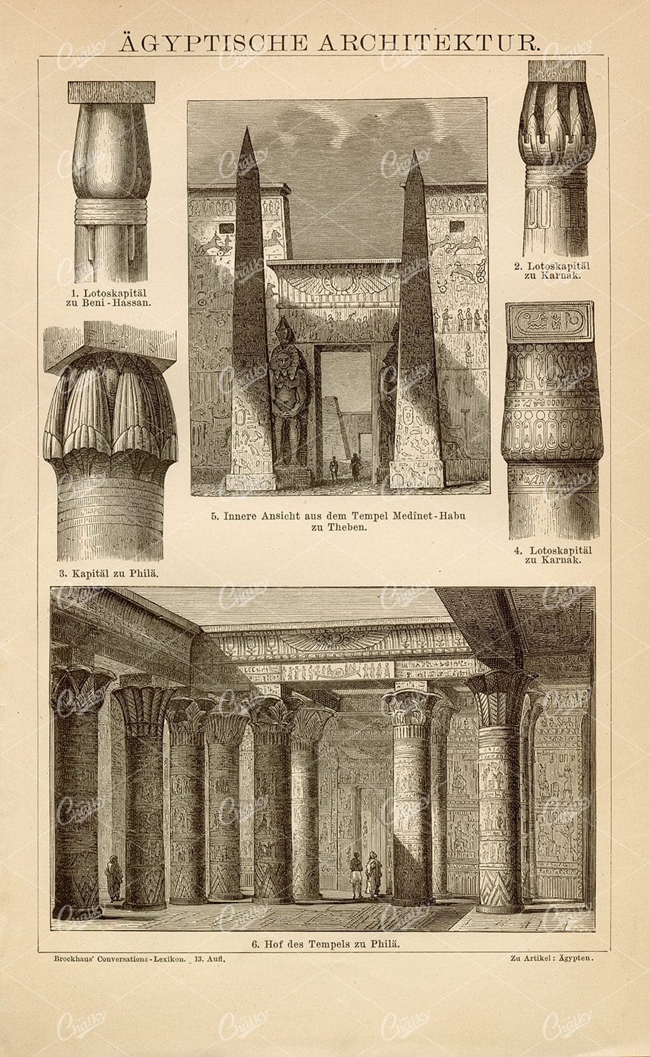
EGYPTIAN Architecture Vintage Print – Antique Encyclopedia Print
- License Info
- Resolution: 5533px x 8818px
- Year of Print: 1882
Related Images

OWEN JONES Elizabethan No 1 – Vintage 1865 Print – Original
- License Info
- Resolution: 7557px x 11698px
- Year of Print: 1865
- Artist: Owen Jones
From this collection

MEDIEVAL Decorative Furniture – Inlaid Muniment Chest 1556 – Antique Print
You're looking at a perfectly preserved lithographed illustration from the Book of Decorative Furniture, its Form, Colour, & History by Edwin Foley of the institute of designers. The original series documented a wide variety of British Woodwork styles and contemporaries, decorative furnishings, accessories and more. Entirely illustrated by Foley himself.
- License Info
- Resolution: 8343 x 6589 300dpi
- Year of Print: 1910
- Artist: Edwin Foley
Related Images

ANTIQUE Furniture – Inlaid Jewel Casket of Walnut Wood
You're looking at a perfectly preserved lithographed illustration from the Book of Decorative Furniture, its Form, Colour, & History by Edwin Foley of the institute of designers. The original series documented a wide variety of British Woodwork styles and contemporaries, decorative furnishings, accessories and more. Entirely illustrated by Foley himself.
- License Info
- Resolution: 8447 x 6756 300dpi
- Year of Print: 1910
- Artist: Edwin Foley
Related Images

VINTAGE 1866 Decorative Arts Print – The Seven deadly Sins
- License Info
- Resolution: 10977px x 15480px
- Year of Print: 1866
- Artist: Michel Lienard
From this collection

ANTIQUE Ornate Border Print Design 1891 Graphic Pattern Exchange
This stunning 19th-century graphic pattern sample was discovered within the ‘Internationaler Graphischer Muster-Austausch des deutschen Buchdrucker-Vereins’ which translates to ‘International graphic pattern exchange of the German book printer association’. Inside was a plethora of gorgeous examples of typography, layout design, printing techniques, and more. A fine display of some of the very best from the print industry of the time and a fantastic source for the modern creator and enthusiast. The demand for beautifully designed printed material spiked during the latter part of the 19th century and with new technical possibilities, demands became more elaborate. To keep up with the times, the best printing companies in Europe and the United States exchanged their finest creations in an attempt to push the industry to new heights. The technologies that would make a faithful reproduction of originals in print possible were still not invented, or deficient. Therefore, professional stakeholders had to exchange their original works among themselves.
- License Info
- Resolution: 7961 x 10390
- Year of Print: 1890
- Artist: Print Association
Related Images

VINTAGE 1843 Map of Tipperary and Waterford – Antique Illustration
- Resolution: 5549px x 8502px
- Year of Print: 1843
- Artist: MR & MRS. S. C. HALL
Related Images

VINTAGE Ornamental Botanical Print – F. Edward Hulme 1874
- License Info
- Resolution: 7923px x 11956px
- Year of Print: 1874
- Artist: F. Edward Hulme
Related Images

ANTIQUE Map of Galway, Ireland – Vintage 1843 Illustration
- Resolution: 8530px x 5604px
- Year of Print: 1843
- Artist: MR & MRS. S. C. HALL
Related Images

VINTAGE Decorative Art Design – Motif for Carving – Antique 1866 Print
- License Info
- Resolution: 10977px x 15480px
- Year of Print: 1866
- Artist: Michel Lienard
From this collection

VINTAGE Map of Kerry, Ireland – Antique 1843 Illustration
- Resolution: 8472px x 5546px
- Year of Print: 1843
- Artist: MR & MRS. S. C. HALL
Related Images

VINTAGE 1843 Map Of Limerick and Clare, Ireland
- Resolution: 8501px x 5589px
- Year of Print: 1843
- Artist: MR & MRS. S. C. HALL
Related Images

VINTAGE Decorative Architecture Print – Examples of Console Fronts
- License Info
- Resolution: 10977px x 15480px
- Year of Print: 1866
- Artist: Michel Lienard
From this collection

RARE Vintage Decorative Arts Print – 19th Century – Crowning Paneling
- License Info
- Resolution: 10977px x 15480px
- Year of Print: 1866
- Artist: Michel Lienard
From this collection

Vintage 1800s Map of Arizona and New Mexico Showing Territorial Boundaries and Natural Features – Antique Map
This vintage map from the 1800s depicts Arizona and New Mexico, highlighting territorial boundaries and natural features. The antique map offers a historical view of the region's geography during a formative period in its history, with intricate details of the landscape and settlements. Ideal for history buffs and map collectors.
- Resolution: 7107 x 5100
- Image Type(s): JPG
- 1800s
- American history
- American West
- Antique
- antique map
- Arizona
- Arizona map
- cartography
- colonial era
- detailed
- exploration
- Geography
- historical
- historical map
- journal
- Map
- natural features
- New Mexico
- New Mexico map
- old map
- political map
- preserved
- regional history
- representation
- retro
- territorial boundaries
- topography
- vintage
- vintage map
From this collection
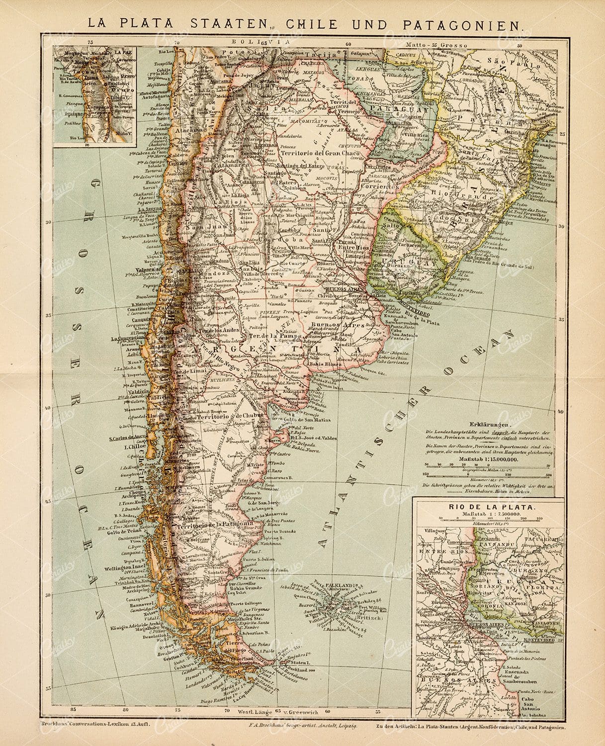
VINTAGE 1882 Map – Chile and Patagonia – Old German Encyclopedia
- License Info
- Resolution: 8691px x 10711px
- Year of Print: 1882
Related Images

VINTAGE 1843 Map – King’s County, Queen’s County and Kilkenny
- Resolution: 5513px x 8526px
- Year of Print: 1843
- Artist: MR & MRS. S. C. HALL
Related Images

RARE 19th Century Decorative Arts Print – Louis XVI Style Panel
- License Info
- Resolution: 10977px x 15480px
- Year of Print: 1866
- Artist: Michel Lienard
From this collection

Vintage Map of Connecticut and Rhode Island Including Major Cities and Coastal Features
A vintage map depicting Connecticut and Rhode Island, highlighting major cities, towns, and coastal features. The map provides detailed insights into the region's transportation routes, geographical features, and historical importance during the period.
- Resolution: 7121 x 5100
- Image Type(s): JPG
From this collection

Antique Map of Southern India and the Straits Settlements with Ceylon
This antique map depicts Southern India and the Straits Settlements, including the island of Ceylon (now Sri Lanka). The map highlights key cities, transportation networks, and topographical features such as rivers and mountain ranges. It provides a historical perspective on the colonial boundaries and geopolitical landscape of the region during the early 20th century, reflecting the connection between Southern India and Southeast Asia.
- Resolution: 7145 x 5100
- Image Type(s): JPG
- early 20th century
- mountain ranges
- British Empire
- colonial boundaries
- Sri Lanka
- Ceylon
- Straits Settlements
- Southern India
- South Asia
- cities
- historical geography
- antique map
- historical map
- exploration
- old map
- cartography
- transportation
- Southeast Asia
- country
- representation
- Indian Ocean
- Antique
- History
- Geography
- Atlas
- World
- Landscape
- Globe
- Rivers
- Map
- Travel
From this collection

VINTAGE Print – A Map of Canaan Showing the Captivities of Israel and Judah
- License Info
- Resolution: 7082px x 9302px
- Year of Print: 1836
- Artist: Charles Taylor
Related Images

ANTIQUE Map of Ireland – Vintage Coloured Print 1800’s
- License Info
- Resolution: 9402px x 11986px
- Year of Print: 1800's
Related Images
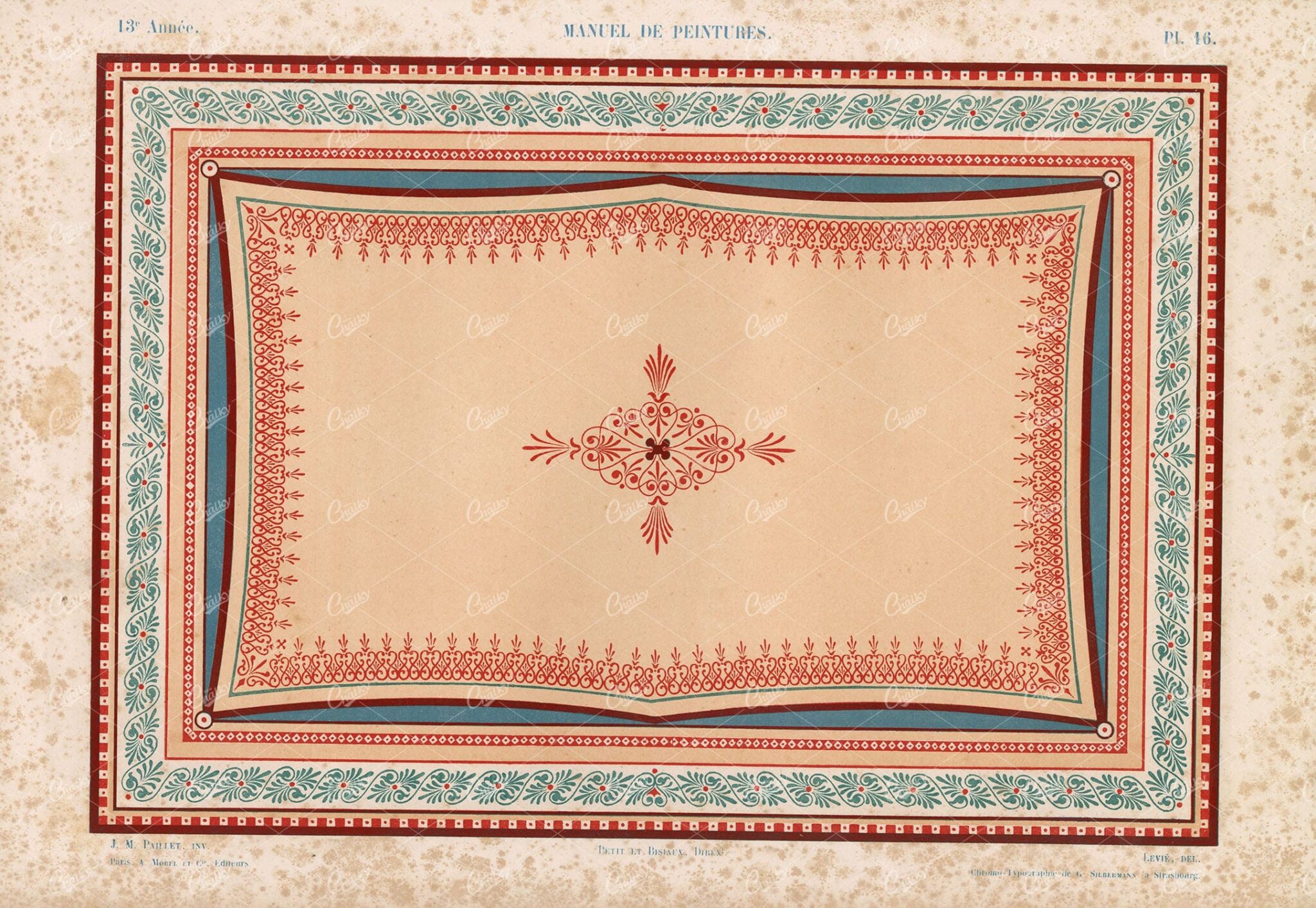
PAINTING – Manuel De Peintures, Decorative Ceiling Mural Lithography
- License Info
- Resolution: 19900 x 13700 300dpi
- Year of Print: 1850
Related Images

Detailed Antique Map of Colorado Highlighting Major Cities and Geographic Features
An antique map of Colorado, showcasing major cities, counties, and detailed geographic features. The map includes railway lines, mountain ranges, and towns, providing a historical perspective on Colorado's development during the time.
- Resolution: 7120 x 5100
- Image Type(s): JPG
From this collection

1843 Vintage Map of the Lakes of Killarney – Antique Illustration
- Resolution: 5680px x 8502px
- Year of Print: 1843
- Artist: MR & MRS. S. C. HALL
Related Images

VINTAGE Biblical Map – Canaan Adapted to the Book of Judges
- License Info
- Resolution: 7010px x 9192px
- Year of Print: 1836
- Artist: Charles Taylor
Related Images

OLD FURNITURE – Henri Deux Carved Coffer and Oak Screen – E. Foley
You're looking at a perfectly preserved lithographed illustration from the Book of Decorative Furniture, its Form, Colour, & History by Edwin Foley of the institute of designers. The original series documented a wide variety of British Woodwork styles and contemporaries, decorative furnishings, accessories and more. Entirely illustrated by Foley himself.
- License Info
- Resolution: 6642 x 8271 300dpi
- Year of Print: 1910
- Artist: Edwin Foley
Related Images

Detailed Antique Map of Iowa with County Boundaries and Transportation Routes
This detailed antique map of Iowa showcases the state's county boundaries, major cities, and transportation routes, including roads and railroads. The map provides a comprehensive view of Iowa's geography during the early 20th century, highlighting the state's agricultural landscape and infrastructure development. It serves as a valuable resource for understanding Iowa's historical growth and its place in the broader Midwest.
- Resolution: 7147 x 5100
- Image Type(s): JPG
From this collection

DECORATIVE Antique Interior – Silver Mirror, Gueridons, and Table – Litho
You're looking at a perfectly preserved lithographed illustration from the Book of Decorative Furniture, its Form, Colour, & History by Edwin Foley of the institute of designers. The original series documented a wide variety of British Woodwork styles and contemporaries, decorative furnishings, accessories and more. Entirely illustrated by Foley himself.
- License Info
- Resolution: 6709 x 8359 300dpi
- Year of Print: 1910
- Artist: Edwin Foley
Related Images

Vintage Map of Missouri, Northern Part with Cities and Roads
A vintage map showing the northern part of Missouri, including cities, roads, and county lines, reflecting the region's infrastructure and geography from the early 20th century.
- Resolution: 7168 x 5100
- Image Type(s): JPG
From this collection

Antique 1800s Map of Central Africa Featuring Colonial Territories and Natural Features – Vintage Historical Map
This detailed antique map from the 1800s depicts Central Africa, highlighting various colonial territories, natural features, and historical locations. It showcases the intricate geography of the region during the colonial period, offering a glimpse into the past through this vintage, beautifully preserved map.
- Resolution: 7100 x 5100
- Image Type(s): JPG
- 1800s
- Africa
- Africa colonial
- Africa map
- Antique
- antique illustration
- Atlas
- Borders
- cartography
- Central Africa
- colonial
- colonialism
- detailed
- exploration
- Geography
- historical
- historical map
- History
- illustration
- Map
- Mountains
- natural features
- old map
- past
- preserved
- regions
- representation
- retro
- Rivers
- territories
- topography
- vintage
- vintage map
- World
From this collection

Support the Library
Our supporters and members help us continue collecting and restoring these wonderful pieces of art for the modern creator
Unlock Everything and Become a Member!
While a lot of the library is available for free, some is kept behind closed dusty doors only to be accessed by our lovely members.