
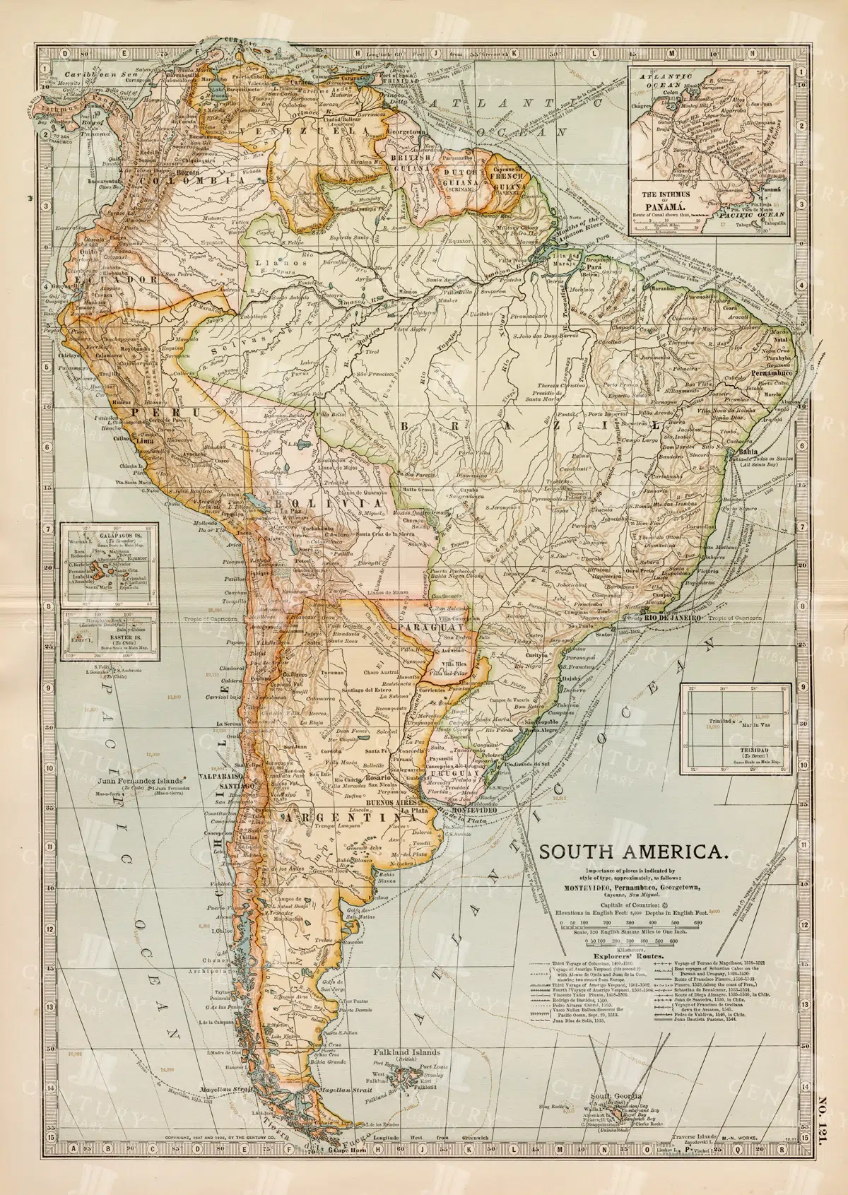
Complete 19th Century Map of South America with Geographical Details
A comprehensive 19th century map of South America, illustrating the continent's countries, cities, and geographical features in great detail. This vintage map provides an overview of the political landscape and natural features of the era.
- Resolution: 7262 x 5100
- Image Type(s): JPG
- complete map
- map of South America
- archival
- historical document
- antique cartography
- historical records
- history lovers
- historical artifact
- historical information
- antique paper
- political divisions
- geographical features
- South American history
- old South America
- Latin America
- topography
- cities
- historical geography
- antique map
- historical map
- old map
- cartography
- vintage map
- cartographic history
- 1800s
- 19th-century
- heritage
- vintage
- representation
- South America
- Geography
- Atlas
- World
- Map
From this collection

Vintage 1800s Map of Alaska Featuring Detailed Geography and Historical Boundaries – Antique Historical Map
An antique map from the 1800s featuring Alaska, highlighting its detailed geography and historical boundaries. This vintage map offers a glimpse into the early cartographic representation of Alaska, with intricate details of its natural features and political divisions. A perfect addition for those interested in Alaskan history and vintage maps.
- Resolution: 7105 x 5100
- Image Type(s): JPG
From this collection
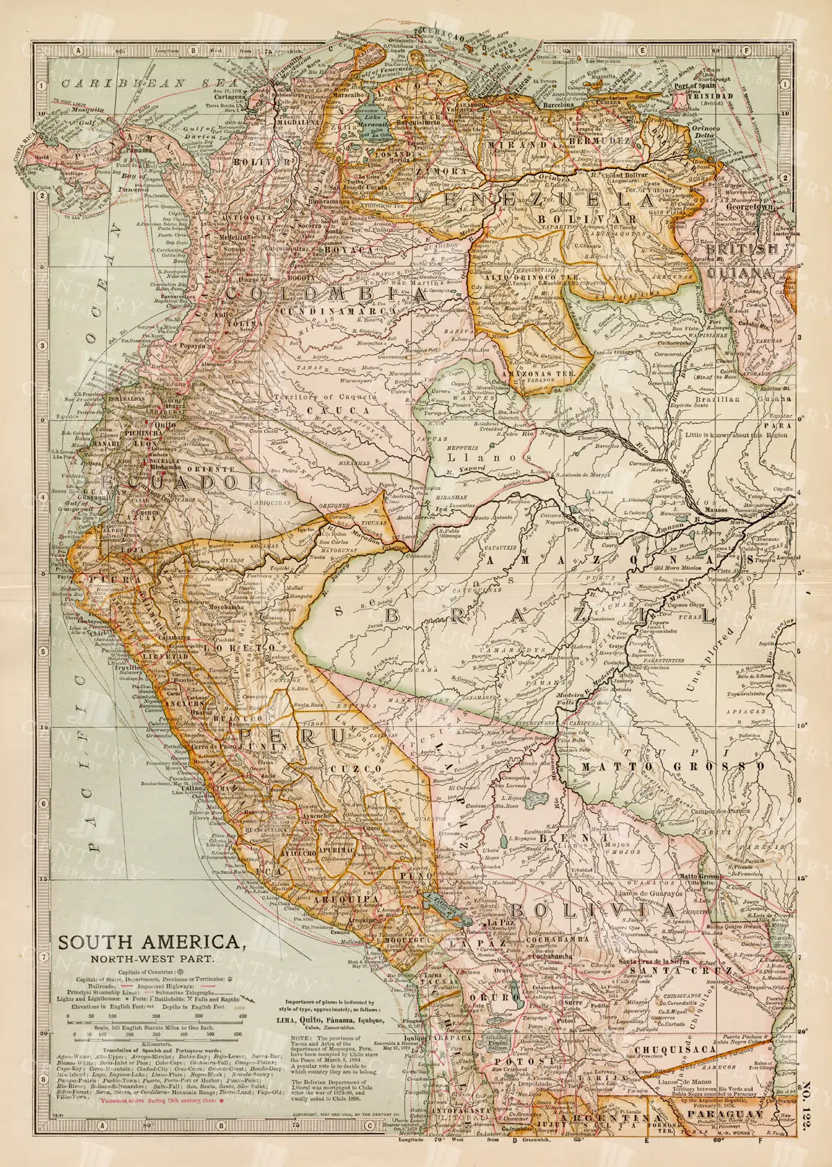
Detailed 19th Century Map of Northwestern South America
A detailed 19th century map illustrating the northwestern part of South America, including countries like Colombia, Venezuela, and Ecuador. This vintage map offers a glimpse into the political and geographical divisions of the era, with detailed insets of major cities and regions.
- Resolution: 7260 x 5100
- Image Type(s): JPG
- archival
- historical document
- antique cartography
- historical records
- history lovers
- historical artifact
- historical information
- antique paper
- political divisions
- geographical features
- South American history
- old South America
- Latin America
- Northwestern South America
- Colombia
- Venezuela
- map of Colombia
- topography
- cities
- historical geography
- antique map
- historical map
- old map
- cartography
- vintage map
- cartographic history
- 1800s
- 19th-century
- heritage
- country
- vintage
- representation
- Antique
- Ecuador
- South America
- Geography
- Atlas
- World
- Globe
- Map
- Travel
- Navigation
From this collection

Vintage 1800s Map of Asia with Emphasis on Siberia and Central Asia – Antique Historical Map
A vintage map from the 1800s featuring Asia, with special emphasis on Siberia and Central Asia. The antique map showcases the vast geography, political boundaries, and natural features of the region, offering a detailed view of Asia during the 19th century. Perfect for those interested in Asian history and vintage cartography.
- Resolution: 7109 x 5100
- Image Type(s): JPG
From this collection

19th Century Map of Southern South America Featuring Argentina and Chile
A richly detailed 19th century map of Southern South America, highlighting countries like Argentina and Chile, with special insets of Buenos Aires, Montevideo, and Valparaiso. This vintage map showcases the region's political and geographical landscape during the era.
- Resolution: 7261 x 5100
- Image Type(s): JPG
- 1800s
- 19th-century
- antique cartography
- antique map
- antique paper
- archival
- Argentina
- Atlas
- Buenos Aires
- cartographic history
- cartography
- Chile
- cities
- geographical features
- Geography
- heritage
- historical artifact
- historical document
- historical geography
- historical information
- historical map
- historical records
- history lovers
- Latin America
- Map
- map of Argentina
- Montevideo
- old map
- old South America
- political divisions
- representation
- South America
- South American history
- Southern South America
- topography
- Valparaiso
- vintage
- vintage map
- World
From this collection

19th Century Central Scotland Map Featuring Glasgow and Edinburgh
A vintage map from the 19th century depicting central Scotland, highlighting major cities like Glasgow and Edinburgh. This historical map is rich in detail, showcasing the region's topography, transportation routes, and geographical features during the era.
- Resolution: 7258 x 5100
- Image Type(s): JPG
- archival
- historical document
- antique cartography
- historical records
- history lovers
- historical artifact
- historical information
- antique paper
- geographical features
- central Scotland
- Glasgow
- map of Scotland
- Scottish history
- old Britain
- Scottish Highlands
- Lowlands
- transportation routes
- topography
- cities
- historical geography
- antique map
- historical map
- old map
- cartography
- vintage map
- cartographic history
- 1800s
- 19th-century
- heritage
- Edinburgh
- vintage
- representation
- British History
- Geography
- Atlas
- World
- Map
- United Kingdom
- Scotland
From this collection
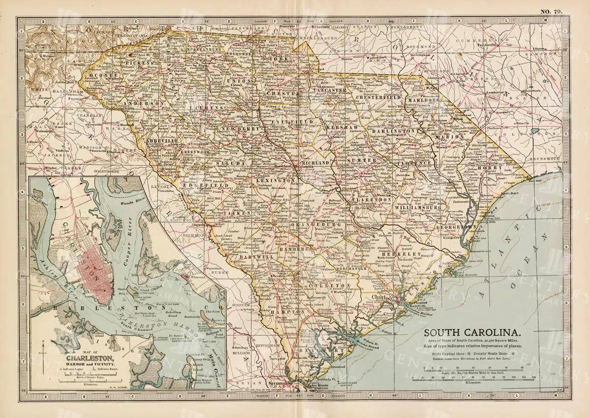
19th Century South Carolina Map with Charleston Harbor Inset
A detailed 19th century map of South Carolina, featuring an inset of Charleston Harbor. This vintage map provides a glimpse into the state's political and geographical landscape during the era, highlighting cities, transportation routes, and natural features.
- Resolution: 7263 x 5100
- Image Type(s): JPG
- South Carolina
- Charleston Harbor
- map of South Carolina
- old South Carolina
- Charleston history
- archival
- historical document
- antique cartography
- historical records
- history lovers
- historical artifact
- historical information
- antique paper
- political divisions
- geographical features
- topography
- cities
- historical geography
- antique map
- historical map
- old map
- cartography
- vintage map
- American history
- cartographic history
- 1800s
- 19th-century
- heritage
- country
- vintage
- representation
- Geography
- Atlas
- World
- United States
- Map
From this collection
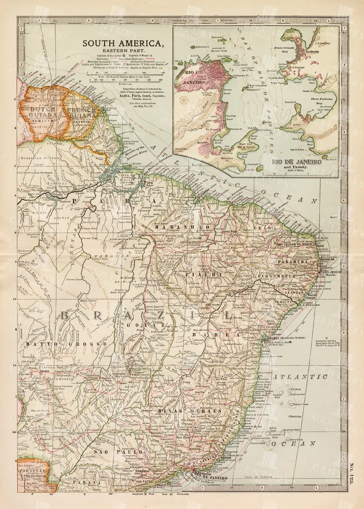
19th Century Map of Eastern South America Including Rio de Janeiro
A detailed 19th century map of Eastern South America, focusing on countries like Brazil, French Guiana, and others, with a special inset of Rio de Janeiro. This vintage map illustrates the political and geographical landscape of the time, with precise details of cities and natural features.
- Resolution: 7259 x 5100
- Image Type(s): JPG
- 1800s
- 19th-century
- antique cartography
- antique map
- antique paper
- archival
- Atlas
- Brazil
- cartographic history
- cartography
- cities
- Eastern South America
- French Guiana
- geographical features
- Geography
- heritage
- historical artifact
- historical document
- historical geography
- historical information
- historical map
- historical records
- history lovers
- Latin America
- Map
- map of Brazil
- old map
- old South America
- political divisions
- representation
- Rio de Janeiro
- South America
- South American history
- topography
- vintage
- vintage map
- World
From this collection
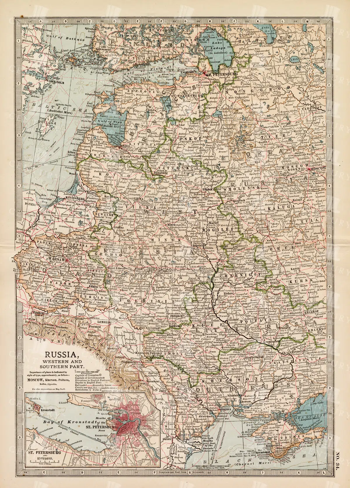
19th Century Map of Russia’s Western and Southern Parts with St. Petersburg
A detailed 19th century map highlighting the western and southern parts of Russia, including the prominent city of St. Petersburg. This vintage map showcases the political and geographical landscape of the era, featuring intricate details of cities, rivers, and borders.
- Resolution: 7257 x 5100
- Image Type(s): JPG
- 1800s
- 19th-century
- Antique
- antique cartography
- antique map
- antique paper
- archival
- Atlas
- Baltic Sea
- cartographic history
- cartography
- cities
- Eastern Europe
- european history
- geographical features
- Geography
- heritage
- historical artifact
- historical document
- historical geography
- historical information
- historical map
- historical records
- history lovers
- Map
- map of Russia
- old
- old Europe
- old map
- political divisions
- representation
- Rivers
- Russia
- Russian Empire
- southern Russia
- St. Petersburg
- St. Petersburg history
- topography
- vintage
- vintage map
- western Russia
From this collection

19th Century Russia in Europe with Poland and Finland Vintage Map
A detailed 19th century map depicting Russia in Europe, including Poland and Finland. This historical artifact provides insight into the territorial boundaries and political divisions of the time, with intricate detailing of cities, rivers, and topographical features.
- Resolution: 7256 x 5100
- Image Type(s): JPG
- 1800s
- 19th-century
- Antique
- antique cartography
- antique map
- antique paper
- archival
- Atlas
- Baltic Sea
- Black Sea
- cartographic history
- cartography
- cities
- Eastern Europe
- european history
- Finland
- Finland history
- Geography
- heritage
- historical artifact
- historical document
- historical geography
- historical information
- historical map
- historical records
- history lovers
- Map
- map of Russia
- old Europe
- old map
- Poland
- Poland history
- political divisions
- representation
- Rivers
- Russia in Europe
- Russian Empire
- territorial boundaries
- topography
- vintage
- vintage map
- World
From this collection

Antique 1800s Map of Arkansas with Detailed County Lines and Natural Features – Vintage Historical Cartography
An antique map from the 1800s showcasing Arkansas, with detailed county lines and natural features. This vintage map provides a historical view of Arkansas’s geography during the 19th century, offering a beautifully preserved piece of the state’s cartographic history.
- Resolution: 7108 x 5100
- Image Type(s): JPG
From this collection

Detailed 19th Century Map of Quebec, Canada with Historical Context
A richly detailed 19th century map of Quebec, Canada, showcasing various regions, cities, and geographical features. This historical map provides a glimpse into the past, reflecting the administrative and territorial divisions of the era. Insets highlight key areas, enhancing the map's informative value.
- Resolution: 7255 x 5100
- Image Type(s): JPG
- historical context
- Canadian history
- territorial divisions
- map insets
- archival
- historical document
- geography of Quebec
- Canadian provinces
- antique cartography
- St. Lawrence River
- historical records
- old Quebec
- history lovers
- historical artifact
- map of Canada
- historical information
- Quebec history
- antique paper
- educational tool
- detailed map
- regions
- topography
- cities
- historical geography
- antique map
- historical map
- old map
- cartography
- vintage map
- cartographic history
- 1800s
- 19th-century
- heritage
- country
- vintage
- representation
- Montreal
- Quebec
- Geography
- Atlas
- World
- Canada
- North America
- Map
From this collection

19th Century Map of South Dakota with County Divisions
A detailed 19th century map of South Dakota, showcasing the state's counties, cities, and geographical features. This vintage map offers insight into the political and territorial divisions of the era, with intricate details of rivers and topography.
- Resolution: 7264 x 5100
- Image Type(s): JPG
- 1800s
- 19th-century
- American history
- antique cartography
- antique map
- antique paper
- archival
- cartographic history
- cartography
- cities
- county divisions
- geographical features
- Geography
- heritage
- historical artifact
- historical document
- historical geography
- historical information
- historical map
- historical records
- history lovers
- Map
- map of South Dakota
- old map
- old South Dakota
- Plan
- political divisions
- representation
- South Dakota
- state map
- territorial divisions
- topography
- United States
- vintage
- vintage map
From this collection

Support the Library
Our supporters and members help us continue collecting and restoring these wonderful pieces of art for the modern creator
Unlock Everything and Become a Member!
While a lot of the library is available for free, some is kept behind closed dusty doors only to be accessed by our lovely members.