

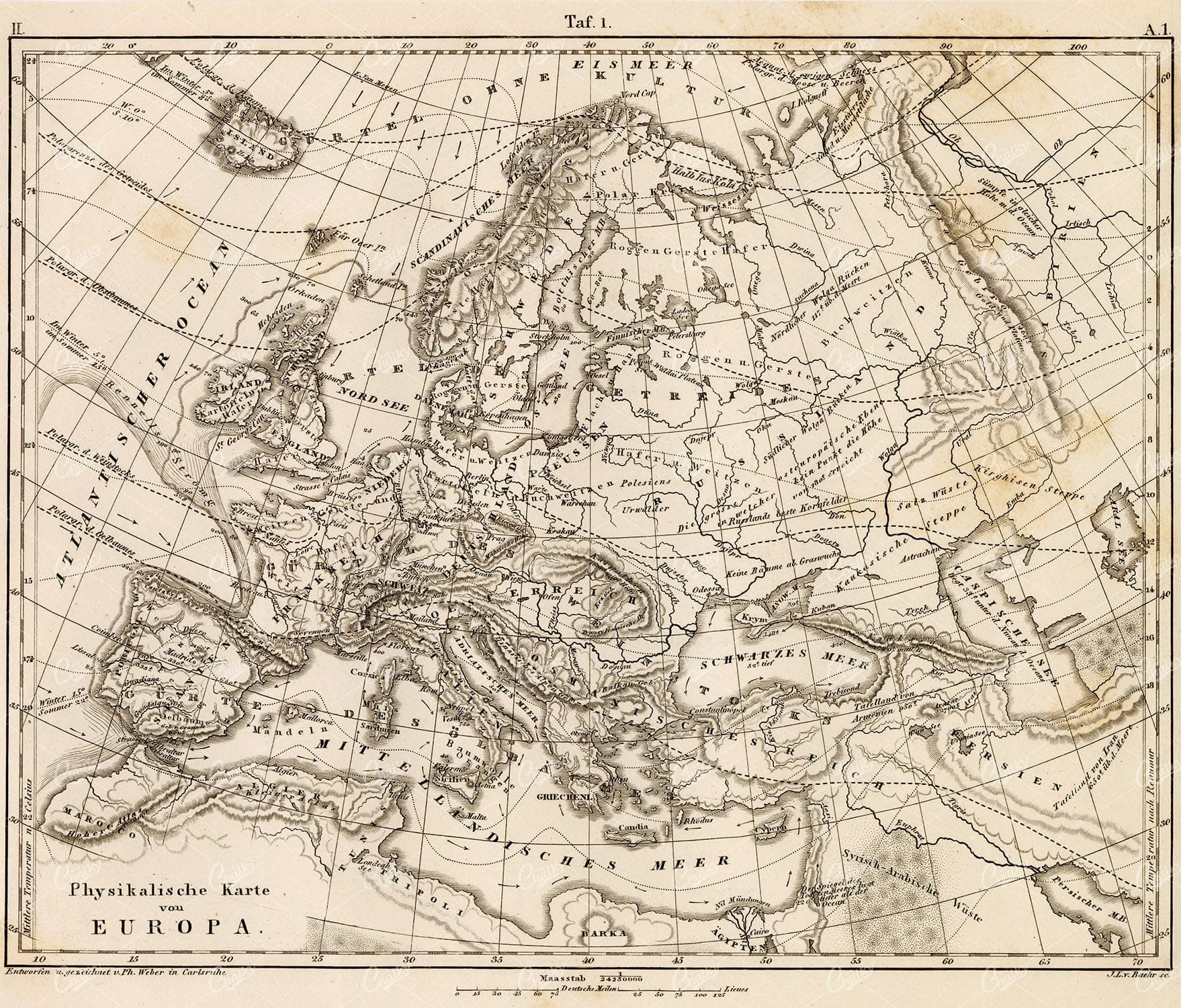
Vintage Map of Europe Showing Key Regions and Countries
This vintage map of Europe provides a detailed view of the continent’s countries, regions, and geographical features. The map offers a historical perspective on Europe’s political boundaries and major cities during the time period. Its detailed cartography and vintage aesthetic make it a valuable resource for historians, collectors, and anyone interested in European history. The map includes insets of various regions, adding further detail and context.
- Resolution: 7131 x 5100
- Image Type(s): JPG
- european history
- detailed map
- europe map
- vintage cartography
- european cartography
- old european map
- detailed europe map
- europe vintage
- historical europe
- old europe map
- europe countries
- european regions
- vintage europe
- european geography
- europe regions
- europe geography
- antique europe
- europe cartography
- europe map vintage
- european cities
- regions
- historical geography
- antique map
- historical map
- old map
- countries
- historical
- country
- vintage
- representation
- Geography
- Atlas
- World
- Map
- Europe
- Travel
From this collection

Vintage Map of Ireland Highlighting Political Boundaries and Topographical Features
This vintage map of Ireland highlights the country's political boundaries and key topographical features, including rivers, mountains, and major cities. The map provides a historical overview of Ireland during the late 19th century, offering insight into the geopolitical landscape and cultural heritage of the island. It includes detailed insets of Dublin and its surrounding areas, reflecting Ireland's rich history and complex political past.
- Resolution: 7149 x 5100
- Image Type(s): JPG
- late 19th century
- geopolitical
- Irish history
- Ireland history
- cultural heritage
- topography
- cities
- historical geography
- antique map
- historical map
- exploration
- old map
- cartography
- political boundaries
- Dublin
- vintage
- representation
- Antique
- History
- Island
- Geography
- Atlas
- World
- Landscape
- Ireland
- Rivers
- Mountains
- Map
- United Kingdom
- Europe
From this collection

Detailed 19th Century Map of the Netherlands, Belgium, and Luxembourg
A detailed antique map from the 19th century featuring the Netherlands, Belgium, and Luxembourg. The map showcases the geographical and political landscape of the region, including major cities, rivers, and borders.
- Resolution: 7271 x 5100
- Image Type(s): JPG
From this collection

Antique 19th Century Map of Norway and Sweden with Topographical Details
A beautifully detailed antique map from the 19th century showcasing the countries of Norway and Sweden, with topographical features, major cities, and inset maps of Kristiana and Stockholm.
- Resolution: 7245 x 5100
- Image Type(s): JPG
From this collection

Central Europe Travel Map Featuring Major Cities Like Paris, Berlin, and Vienna
This travel map of Central Europe highlights major cities such as Paris, Berlin, and Vienna, showcasing detailed routes and geographical features. The map provides a glimpse into the historical and political landscape of Central Europe during the time.
- Resolution: 7117 x 5100
- Image Type(s): JPG
From this collection

19th Century Map of Spain, Portugal, and Andorra
An antique map from the 19th century detailing the countries of Spain, Portugal, and Andorra, along with surrounding regions. The map features important cities, mountain ranges, and bodies of water, offering a glimpse into the historical geography of the Iberian Peninsula.
- Resolution: 7266 x 5100
- Image Type(s): JPG
- 19th-century
- Andorra
- Antique
- archives
- Atlantic
- Atlas
- Borders
- cartography
- cities
- country
- Europe
- exploration
- Geography
- heritage
- historic map
- historical
- History
- Iberian Peninsula
- landmarks
- Landscape
- Map
- Mediterranean
- Mountains
- old map
- Portugal
- Pyrenees
- reference
- representation
- retro
- Rivers
- settlements
- Spain
- topographic
- vintage
- vintage map
- World
From this collection

Antique Historical Map of Western Austria-Hungary Featuring Vienna and Prague
An antique map of the western part of Austria-Hungary, highlighting major cities like Vienna and Prague. The map provides intricate details of regional boundaries, railway networks, and topographical features, reflecting the historical political landscape of the region.
- Resolution: 7111 x 5100
- Image Type(s): JPG
From this collection

Empire of Austria-Hungary Historical Map with Detailed Regional Boundaries and Railways
This historical map of the Austria-Hungary Empire showcases detailed regional boundaries, cities, and extensive railway networks. The map includes significant areas like Budapest and Vienna, providing a comprehensive view of the empire's geographical and political landscape during the period.
- Resolution: 7112 x 5100
- Image Type(s): JPG
From this collection

19th Century Map of Switzerland, Liechtenstein, and Parts of Austria-Hungary
A detailed antique map from the 19th century showcasing Switzerland, Liechtenstein, and parts of Austria-Hungary. The map highlights the mountainous terrain, lakes, and major cities, reflecting the historical borders and settlements of the region.
- Resolution: 7267 x 5100
- Image Type(s): JPG
From this collection

ANTIQUE Map of Europe – Original Vintage 1836 Print
- License Info
- Resolution: 8398px x 7296px
- Year of Print: 1836
- Artist: Charles Taylor
Related Images
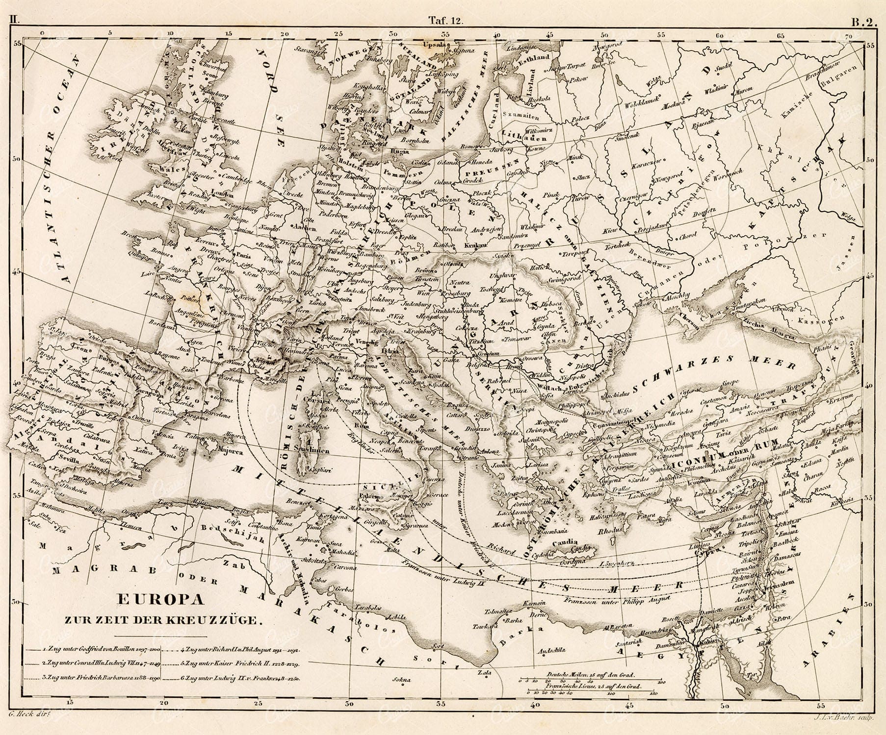
GEOGRAPHY – Europe at the Time of the Crusades – 1851 Antique Print
You’re looking at a well preserved original plate from Johann Georg Heck's “Iconographic Encyclopedia of Sciences, Literature and Art” published in 1851 by Rudolphe Garrigue in New York. We were extremely fortunate to acquire the full collection of illustrative prints from the series, which after many months of looking, proved to be very difficult!
- License Info
- Resolution: 9380 x 7792 300dpi
- Year of Print: 1851
- Artist: Johann Georg Heck
From this collection

EUROPE Map, Antique 1880 Stock Image. William Mackenzie
An original Antique Plate scan from the National Encyclopaedia: A Dictionary of Universal Knowledge. Published by William Mackenzie in 1880. Click on the Artist's name to see the full collection from this series!
- License Info
- Resolution: 7594 x 10009 300dpi
- Year of Print: 1880
- Artist: William Mackenzie
From this collection
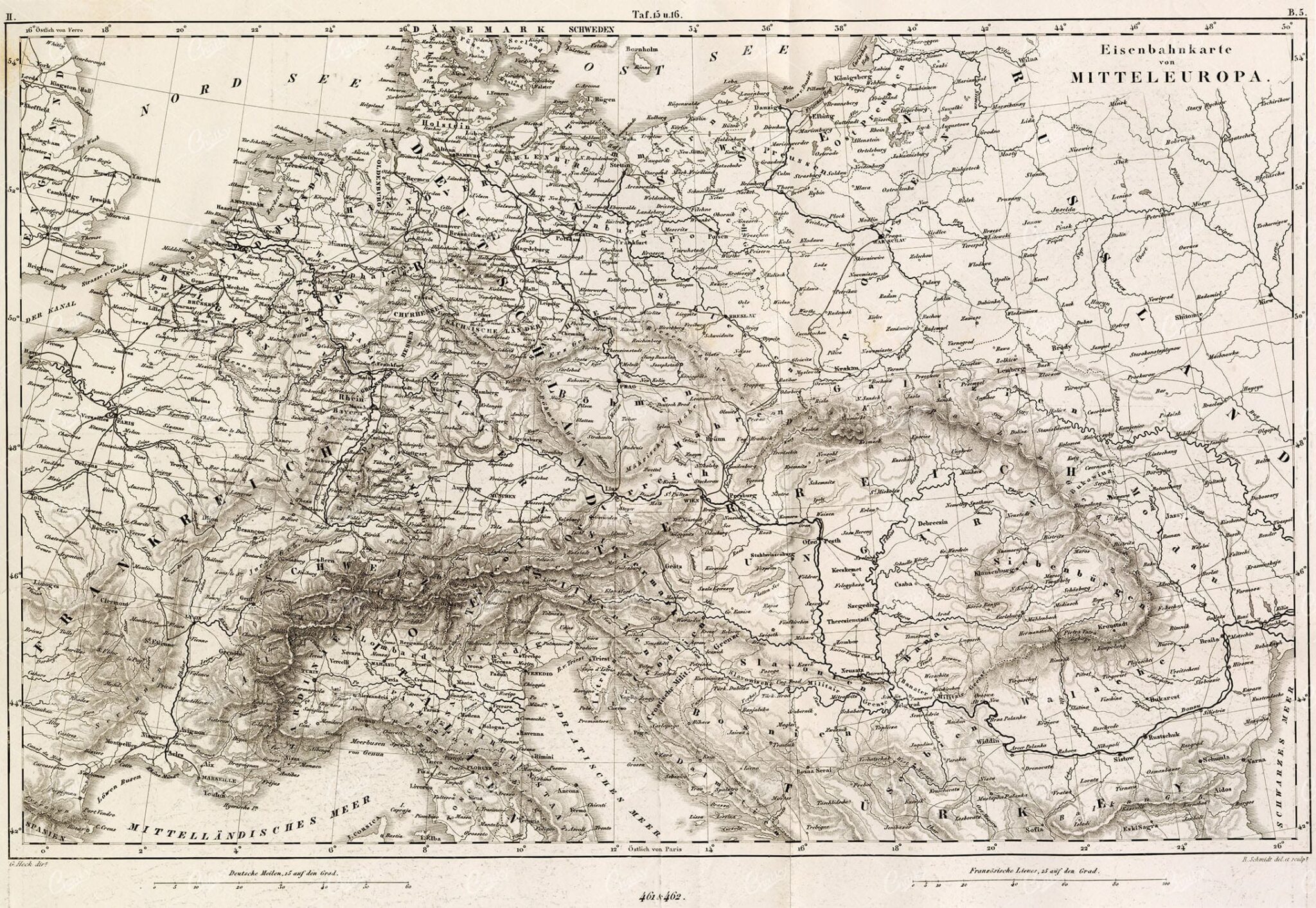
ANTIQUE Map – Railroads of Central Europe – Original 1851 Fold Out Print
You’re looking at a well preserved original plate from Johann Georg Heck's “Iconographic Encyclopedia of Sciences, Literature and Art” published in 1851 by Rudolphe Garrigue in New York. We were extremely fortunate to acquire the full collection of illustrative prints from the series, which after many months of looking, proved to be very difficult!
- License Info
- Resolution: 14512 x 10009 300dpi
- Year of Print: 1851
- Artist: Johann Georg Heck
From this collection
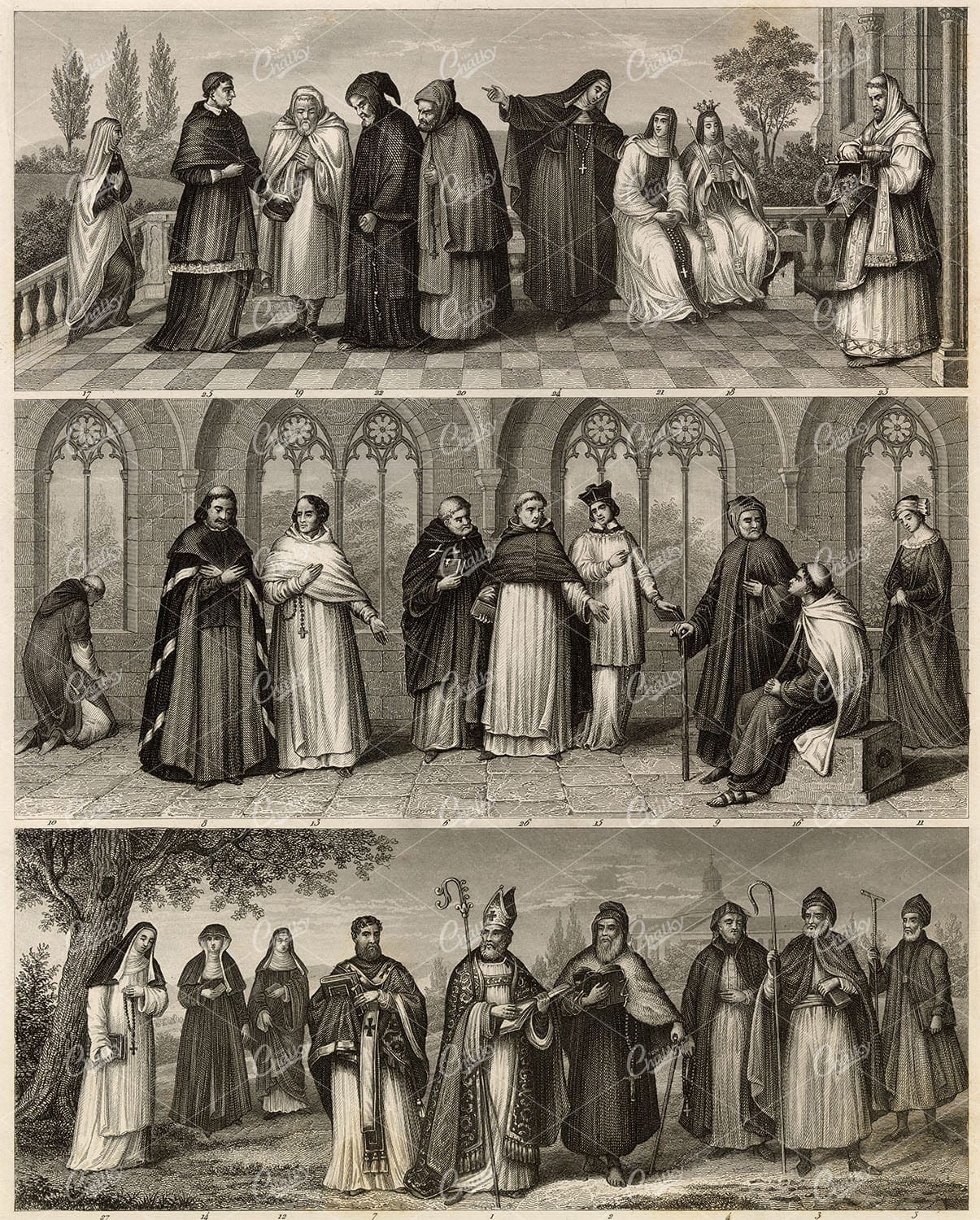
COSTUME of Central Europe – Antique Heck’s Iconography Engraving 1851
You’re looking at a well preserved original plate from Johann Georg Heck's “Iconographic Encyclopedia of Sciences, Literature and Art” published in 1851 by Rudolphe Garrigue in New York. We were extremely fortunate to acquire the full collection of illustrative prints from the series, which after many months of looking, proved to be very difficult!
- License Info
- Resolution: 7280 x 9063 300dpi
- Year of Print: 1851
- Artist: Johann Georg Heck
From this collection
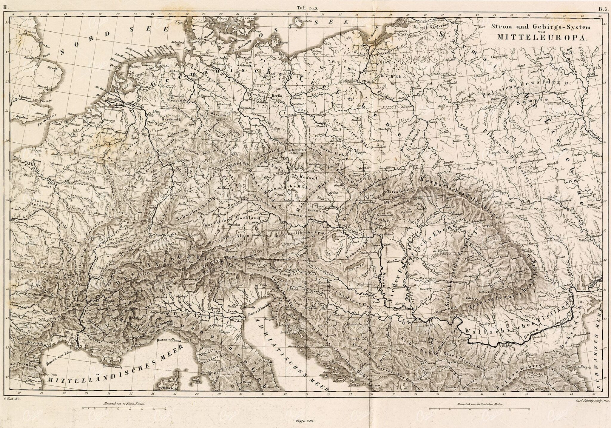
MOUNTAIN and River System of Central Europe – Antique Foldout Map
You’re looking at a well preserved original plate from Johann Georg Heck's “Iconographic Encyclopedia of Sciences, Literature and Art” published in 1851 by Rudolphe Garrigue in New York. We were extremely fortunate to acquire the full collection of illustrative prints from the series, which after many months of looking, proved to be very difficult!
- License Info
- Resolution: 14559 x 10191 300dpi
- Year of Print: 1851
- Artist: Johann Georg Heck
From this collection

ANTIQUE Map – Europe Before the French Revolution 1851 Original Print
You’re looking at a well preserved original plate from Johann Georg Heck's “Iconographic Encyclopedia of Sciences, Literature and Art” published in 1851 by Rudolphe Garrigue in New York. We were extremely fortunate to acquire the full collection of illustrative prints from the series, which after many months of looking, proved to be very difficult!
- License Info
- Resolution: 9316 x 7817 300dpi
- Year of Print: 1851
- Artist: Johann Georg Heck
From this collection
GEOGRAPHY and Planography – Antique Map of Europe 1851 Print
You’re looking at a well preserved original plate from Johann Georg Heck's “Iconographic Encyclopedia of Sciences, Literature and Art” published in 1851 by Rudolphe Garrigue in New York. We were extremely fortunate to acquire the full collection of illustrative prints from the series, which after many months of looking, proved to be very difficult!
- License Info
- Resolution: 9266 x 7906 300dpi
- Year of Print: 1851
- Artist: Johann Georg Heck
From this collection

MAPS – Antique Map of EUROPE from RARE Abraham REES Encyclopaedia 1800s
You're looking at an Original pre-1820's Antique Engraving from a rare copy of Abraham Rees' "The Cyclopaedia; or, UNIVERSAL DICTIONARY OF ARTS, SCIENCES, and LITERATURE" (Published 1820 by Longman, Hurst, Rees, Orme)
- License Info
- Resolution: 9350 x 7400 300dpi
- Year of Print: 1800s
- Artist: Abraham Rees
From this collection

ANTIQUE 1868 Geology Print – Principle Geological Features of Europe Map
Here we have a high resolution scan of a wonderful lithograph print from Oliver Goldsmith's "A History of the Earth and Animated Nature". A celebrated series of books from the 1860's, wherein the most distinguished British and Foreign naturalists collaborated to produce.
- License Info
- Resolution: 5029 x 8548 300dpi
- Year of Print: 1868
- Artist: Oliver Goldsmith
From this collection

EUROPE, France, Alsacian Female – Antique Handcoloured Native Fashion
You're looking at a beautifully handcoloured illustration from the rare 'Moeurs, Usages Et Costumes de tous les Peuples Du Monde' by Auguste Wahlen. Published by Librairie Historique-Artistique in 1843-44 (currently selling for ~£450-500). Our series was ex-library from Huddersfield Technical College Library, as evidenced by the library stamp on the vast majority of the images we have available.
- License Info
- Resolution: 5578 x 8885 300dpi
- Year of Print: 1843
- Artist: Auguste Wahlen
Related Images

ANTIQUE Map of Europe – Johann Heck 1851 Original Geography Print
You’re looking at a well preserved original plate from Johann Georg Heck's “Iconographic Encyclopedia of Sciences, Literature and Art” published in 1851 by Rudolphe Garrigue in New York. We were extremely fortunate to acquire the full collection of illustrative prints from the series, which after many months of looking, proved to be very difficult!
- License Info
- Resolution: 9368 x 7852 300dpi
- Year of Print: 1851
- Artist: Johann Georg Heck
From this collection

EUROPEAN Turkey, Romania, Servia, Montenegro & Bulgaria, 1880 Vintage Map
An original Antique Plate scan from the National Encyclopaedia: A Dictionary of Universal Knowledge. Published by William Mackenzie in 1880. Click on the Artist's name to see the full collection from this series!
- License Info
- Resolution: 7594 x 10009 300dpi
- Year of Print: 1880
- Artist: William Mackenzie
From this collection

GEOGRAPHY – Europe in the Time of Charlemagne – 1851 Antique Print
You’re looking at a well preserved original plate from Johann Georg Heck's “Iconographic Encyclopedia of Sciences, Literature and Art” published in 1851 by Rudolphe Garrigue in New York. We were extremely fortunate to acquire the full collection of illustrative prints from the series, which after many months of looking, proved to be very difficult!
- License Info
- Resolution: 9346 x 7951 300dpi
- Year of Print: 1851
- Artist: Johann Georg Heck
From this collection
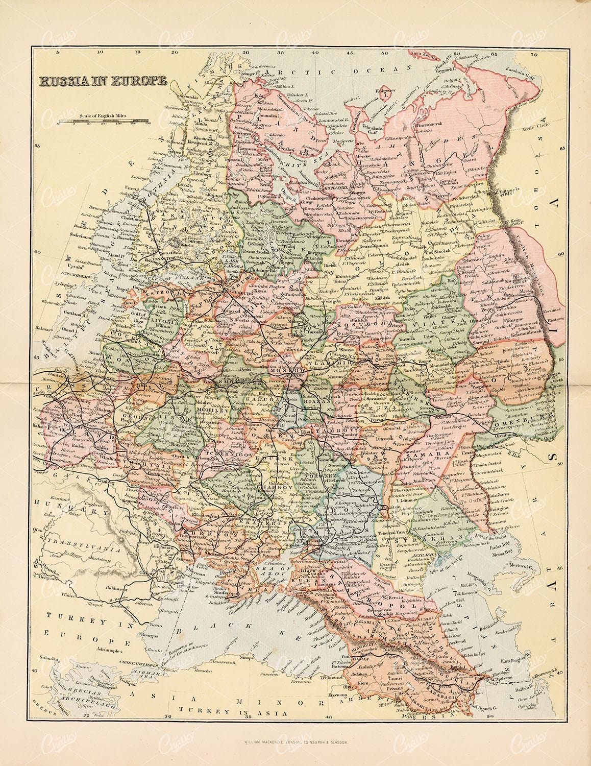
RUSSIA IN EUROPE Vintage 1880 Map Stock Image
An original Antique Plate scan from the National Encyclopaedia: A Dictionary of Universal Knowledge. Published by William Mackenzie in 1880. Click on the Artist's name to see the full collection from this series!
- License Info
- Resolution: 7594 x 10009 300dpi
- Year of Print: 1880
- Artist: William Mackenzie
From this collection

ANTIQUE Map of Europe – Original Vintage 1836 Print
- License Info
- Resolution: 8715px x 7344px
- Year of Print: 1836
- Artist: Charles Taylor
Related Images

EUROPE Map at the Dismemberment of the Carlovingian Empire, 1880
An original Antique Plate scan from the National Encyclopaedia: A Dictionary of Universal Knowledge. Published by William Mackenzie in 1880. Click on the Artist's name to see the full collection from this series!
- License Info
- Resolution: 7594 x 10009 300dpi
- Year of Print: 1880
- Artist: William Mackenzie
From this collection

Support the Library
Our supporters and members help us continue collecting and restoring these wonderful pieces of art for the modern creator
Unlock Everything and Become a Member!
While a lot of the library is available for free, some is kept behind closed dusty doors only to be accessed by our lovely members.