

VINTAGE 1843 Map of Fermanagh, Leitrim and Longford
- Resolution: 5645px x 8538px
- Year of Print: 1843
- Artist: MR & MRS. S. C. HALL
Related Images


GEOGRAPHY – Roman Empire Under Constantine the Great – 1851 Print
You’re looking at a well preserved original plate from Johann Georg Heck's “Iconographic Encyclopedia of Sciences, Literature and Art” published in 1851 by Rudolphe Garrigue in New York. We were extremely fortunate to acquire the full collection of illustrative prints from the series, which after many months of looking, proved to be very difficult!
- License Info
- Resolution: 9346 x 7735 300dpi
- Year of Print: 1851
- Artist: Johann Georg Heck
From this collection

GEOGRAPHY – Vintage Analemma Print – Abraham REES Encyclopaedia
You're looking at an Original pre-1820's Antique Engraving from a rare copy of Abraham Rees' "The Cyclopaedia; or, UNIVERSAL DICTIONARY OF ARTS, SCIENCES, and LITERATURE" (Published 1820 by Longman, Hurst, Rees, Orme)
- License Info
- Resolution: 7400 x 9350 300dpi
- Year of Print: 1800s
- Artist: Abraham Rees
From this collection

Antique Map of Southern India and the Straits Settlements with Ceylon
This antique map depicts Southern India and the Straits Settlements, including the island of Ceylon (now Sri Lanka). The map highlights key cities, transportation networks, and topographical features such as rivers and mountain ranges. It provides a historical perspective on the colonial boundaries and geopolitical landscape of the region during the early 20th century, reflecting the connection between Southern India and Southeast Asia.
- Resolution: 7145 x 5100
- Image Type(s): JPG
- early 20th century
- mountain ranges
- British Empire
- colonial boundaries
- Sri Lanka
- Ceylon
- Straits Settlements
- Southern India
- South Asia
- cities
- historical geography
- antique map
- historical map
- exploration
- old map
- cartography
- transportation
- Southeast Asia
- country
- representation
- Indian Ocean
- Antique
- History
- Geography
- Atlas
- World
- Landscape
- Globe
- Rivers
- Map
- Travel
From this collection

Vintage Map of Connecticut and Rhode Island Including Major Cities and Coastal Features
A vintage map depicting Connecticut and Rhode Island, highlighting major cities, towns, and coastal features. The map provides detailed insights into the region's transportation routes, geographical features, and historical importance during the period.
- Resolution: 7121 x 5100
- Image Type(s): JPG
From this collection
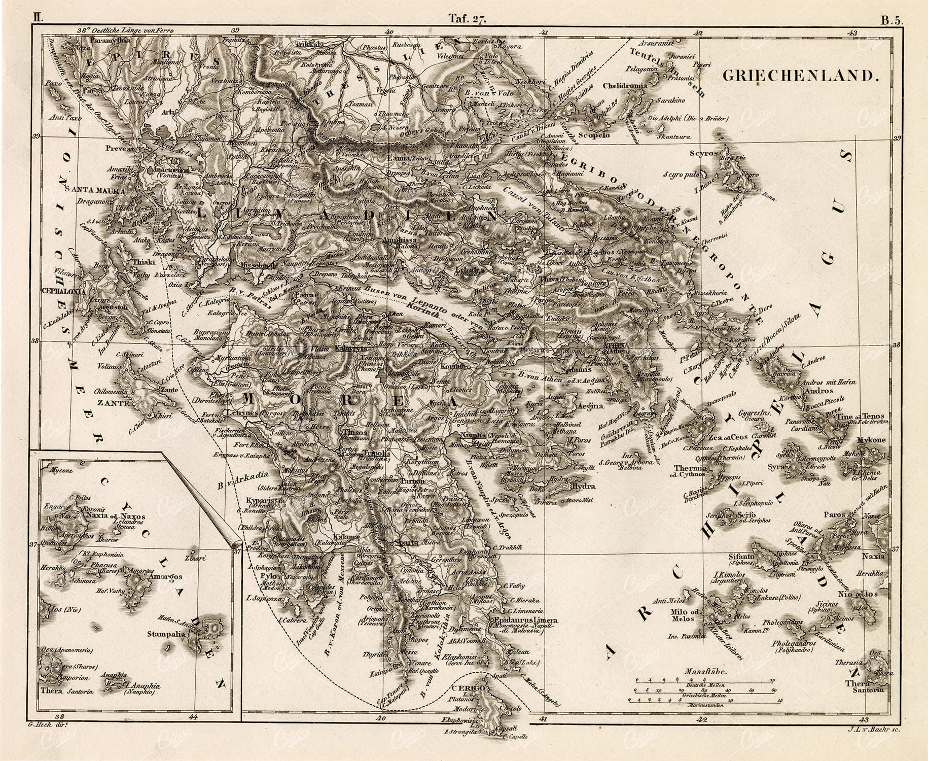
GEOGRAPHY – Map of Greece – Antique 1851 Print by Johann Heck
You’re looking at a well preserved original plate from Johann Georg Heck's “Iconographic Encyclopedia of Sciences, Literature and Art” published in 1851 by Rudolphe Garrigue in New York. We were extremely fortunate to acquire the full collection of illustrative prints from the series, which after many months of looking, proved to be very difficult!
- License Info
- Resolution: 9585 x 7856 300dpi
- Year of Print: 1851
- Artist: Johann Georg Heck
From this collection

Detailed Antique Map of Colorado Highlighting Major Cities and Geographic Features
An antique map of Colorado, showcasing major cities, counties, and detailed geographic features. The map includes railway lines, mountain ranges, and towns, providing a historical perspective on Colorado's development during the time.
- Resolution: 7120 x 5100
- Image Type(s): JPG
From this collection

VINTAGE Print – A Map of Canaan Showing the Captivities of Israel and Judah
- License Info
- Resolution: 7082px x 9302px
- Year of Print: 1836
- Artist: Charles Taylor
Related Images

ANTIQUE Map of Ireland – Vintage Coloured Print 1800’s
- License Info
- Resolution: 9402px x 11986px
- Year of Print: 1800's
Related Images

VINTAGE Map of Donegal in Ireland – Antique 1843 Illustration
- Resolution: 8501px x 5503px
- Year of Print: 1843
- Artist: MR & MRS. S. C. HALL
Related Images

VINTAGE Biblical Map – Canaan Adapted to the Book of Judges
- License Info
- Resolution: 7010px x 9192px
- Year of Print: 1836
- Artist: Charles Taylor
Related Images

GEOGRAPHY and Planography – Antique World Map and Mountains
You’re looking at a well preserved original plate from Johann Georg Heck's “Iconographic Encyclopedia of Sciences, Literature and Art” published in 1851 by Rudolphe Garrigue in New York. We were extremely fortunate to acquire the full collection of illustrative prints from the series, which after many months of looking, proved to be very difficult!
- License Info
- Resolution: 9221 x 7724 300dpi
- Year of Print: 1851
- Artist: Johann Georg Heck
From this collection

Vintage Map of Indiana Highlighting Transportation Networks and County Borders
This vintage map of Indiana highlights the state's transportation networks, including roads and railroads, along with its county borders. The map provides a detailed view of Indiana's geography during the early 20th century, focusing on the development of infrastructure and urban areas. It offers a historical overview of the state's growth and the connections between its cities and rural areas.
- Resolution: 7146 x 5100
- Image Type(s): JPG
From this collection

Detailed Antique Map of Iowa with County Boundaries and Transportation Routes
This detailed antique map of Iowa showcases the state's county boundaries, major cities, and transportation routes, including roads and railroads. The map provides a comprehensive view of Iowa's geography during the early 20th century, highlighting the state's agricultural landscape and infrastructure development. It serves as a valuable resource for understanding Iowa's historical growth and its place in the broader Midwest.
- Resolution: 7147 x 5100
- Image Type(s): JPG
From this collection
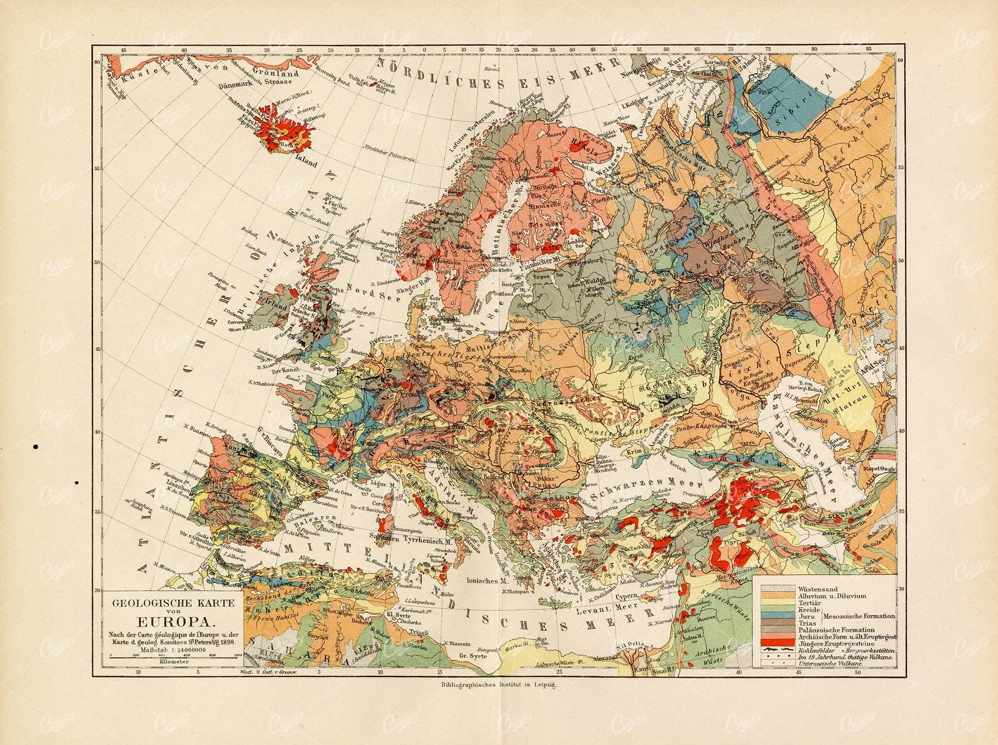
ANTIQUE Geological Map of Europe – Vintage 1800’s Print
- License Info
- Resolution: 11672px x 8718px
- Year of Print: 1800's
Related Images
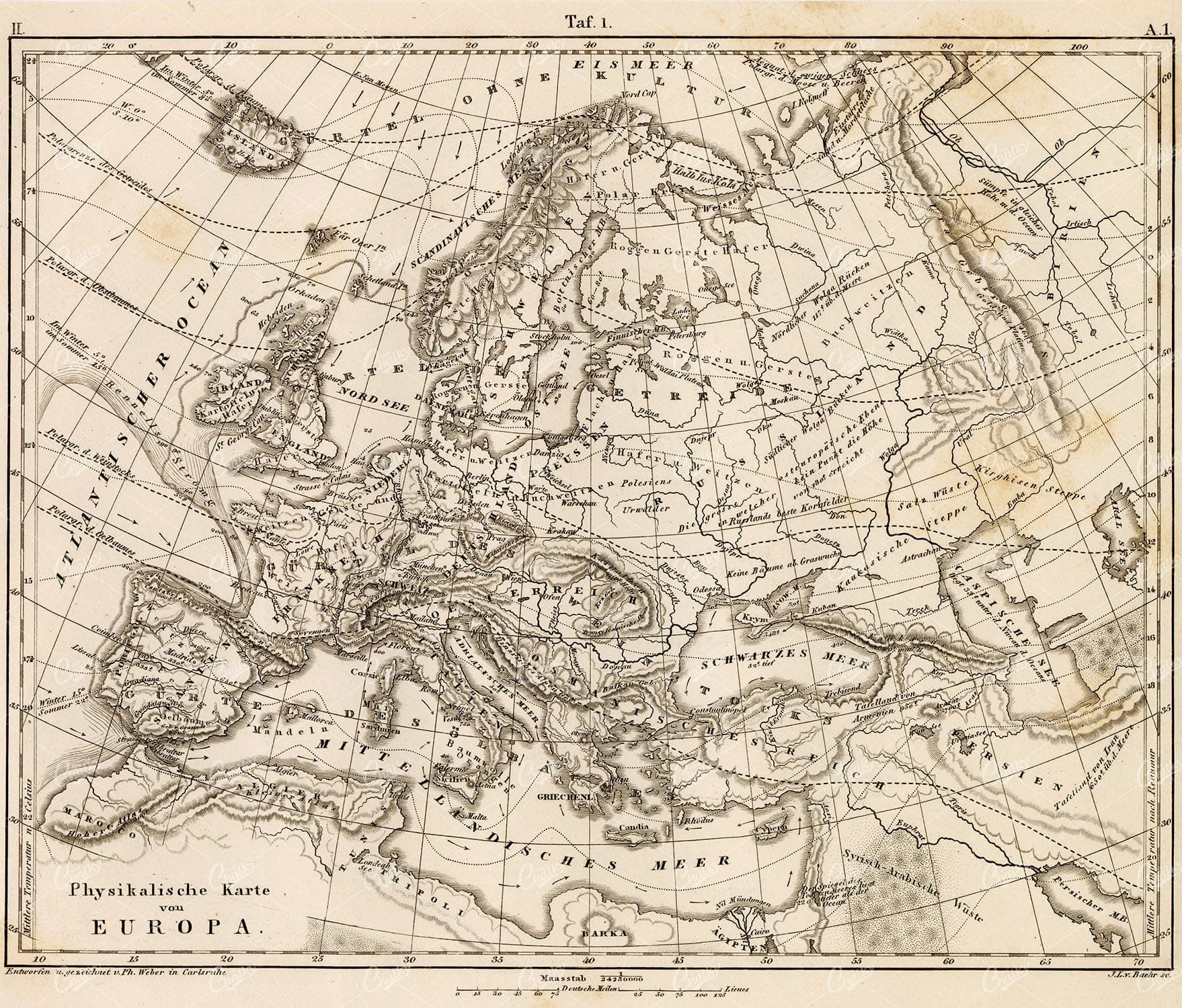
GEOGRAPHY and Planography – Antique Map of Europe 1851 Print
You’re looking at a well preserved original plate from Johann Georg Heck's “Iconographic Encyclopedia of Sciences, Literature and Art” published in 1851 by Rudolphe Garrigue in New York. We were extremely fortunate to acquire the full collection of illustrative prints from the series, which after many months of looking, proved to be very difficult!
- License Info
- Resolution: 9266 x 7906 300dpi
- Year of Print: 1851
- Artist: Johann Georg Heck
From this collection
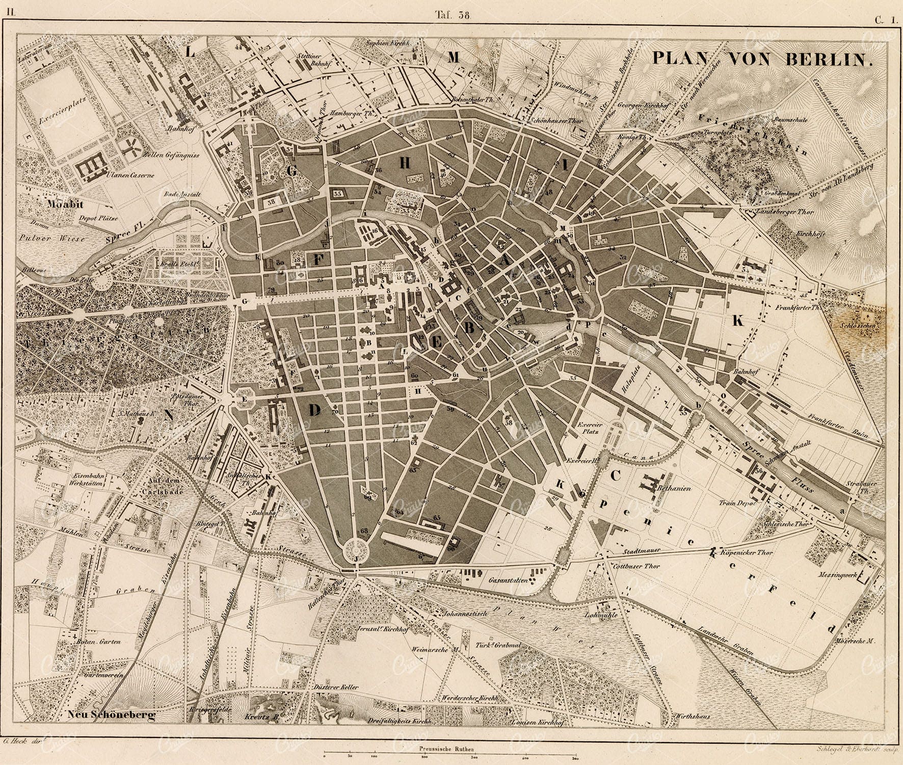
GEOGRAPHY – Berlin – Antique 1851 Map by J. Heck
You’re looking at a well preserved original plate from Johann Georg Heck's “Iconographic Encyclopedia of Sciences, Literature and Art” published in 1851 by Rudolphe Garrigue in New York. We were extremely fortunate to acquire the full collection of illustrative prints from the series, which after many months of looking, proved to be very difficult!
- License Info
- Resolution: 9311 x 7881 300dpi
- Year of Print: 1851
- Artist: Johann Georg Heck
From this collection

ANTIQUE Map of the Isotherms and Isobars of America – Vintage Print
- License Info
- Resolution: 5982px x 8832px
- Year of Print: 1877
Related Images

Vintage Map of Missouri, Northern Part with Cities and Roads
A vintage map showing the northern part of Missouri, including cities, roads, and county lines, reflecting the region's infrastructure and geography from the early 20th century.
- Resolution: 7168 x 5100
- Image Type(s): JPG
From this collection

Antique Map of Mississippi with River and County Details
An antique map of Mississippi focusing on its river systems, county divisions, and major transportation routes, reflecting the state's historical geography from the early 20th century.
- Resolution: 7167 x 5100
- Image Type(s): JPG
From this collection

Antique 1800s Map of Central Africa Featuring Colonial Territories and Natural Features – Vintage Historical Map
This detailed antique map from the 1800s depicts Central Africa, highlighting various colonial territories, natural features, and historical locations. It showcases the intricate geography of the region during the colonial period, offering a glimpse into the past through this vintage, beautifully preserved map.
- Resolution: 7100 x 5100
- Image Type(s): JPG
- 1800s
- Africa
- Africa colonial
- Africa map
- Antique
- antique illustration
- Atlas
- Borders
- cartography
- Central Africa
- colonial
- colonialism
- detailed
- exploration
- Geography
- historical
- historical map
- History
- illustration
- Map
- Mountains
- natural features
- old map
- past
- preserved
- regions
- representation
- retro
- Rivers
- territories
- topography
- vintage
- vintage map
- World
From this collection

GEOGRAPHY – Map of Africa – Antique 1851 Print by Johann Heck
You’re looking at a well preserved original plate from Johann Georg Heck's “Iconographic Encyclopedia of Sciences, Literature and Art” published in 1851 by Rudolphe Garrigue in New York. We were extremely fortunate to acquire the full collection of illustrative prints from the series, which after many months of looking, proved to be very difficult!
- License Info
- Resolution: 9354 x 7782 300dpi
- Year of Print: 1851
- Artist: Johann Georg Heck
From this collection

VINTAGE Map of Tyrone and Down in Ireland – Antique 1843 Illustration
- Resolution: 5633px x 8502px
- Year of Print: 1843
- Artist: MR & MRS. S. C. HALL
Related Images

GEOGRAPHY – The Turkish Empire – Antique 1851 Print by Johann Heck
You’re looking at a well preserved original plate from Johann Georg Heck's “Iconographic Encyclopedia of Sciences, Literature and Art” published in 1851 by Rudolphe Garrigue in New York. We were extremely fortunate to acquire the full collection of illustrative prints from the series, which after many months of looking, proved to be very difficult!
- License Info
- Resolution: 9423 x 7940 300dpi
- Year of Print: 1851
- Artist: Johann Georg Heck
From this collection

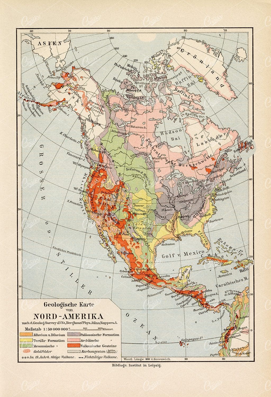
GEOGRAPHY and Planography – Map of North America – Antique 1851 Print
You’re looking at a well preserved original plate from Johann Georg Heck's “Iconographic Encyclopedia of Sciences, Literature and Art” published in 1851 by Rudolphe Garrigue in New York. We were extremely fortunate to acquire the full collection of illustrative prints from the series, which after many months of looking, proved to be very difficult!
- License Info
- Resolution: 9243 x 7883 300dpi
- Year of Print: 1851
- Artist: Johann Georg Heck
From this collection

GEOGRAPHY – Europe in the Time of Charlemagne – 1851 Antique Print
You’re looking at a well preserved original plate from Johann Georg Heck's “Iconographic Encyclopedia of Sciences, Literature and Art” published in 1851 by Rudolphe Garrigue in New York. We were extremely fortunate to acquire the full collection of illustrative prints from the series, which after many months of looking, proved to be very difficult!
- License Info
- Resolution: 9346 x 7951 300dpi
- Year of Print: 1851
- Artist: Johann Georg Heck
From this collection
GEOGRAPHY – Map of North America – Antique 1851 Print by Johann Heck
You’re looking at a well preserved original plate from Johann Georg Heck's “Iconographic Encyclopedia of Sciences, Literature and Art” published in 1851 by Rudolphe Garrigue in New York. We were extremely fortunate to acquire the full collection of illustrative prints from the series, which after many months of looking, proved to be very difficult!
- License Info
- Resolution: 9193 x 7295 300dpi
- Year of Print: 1851
- Artist: Johann Georg Heck
From this collection


GEOGRAPHY – Map of Australia – Antique 1851 Print by Johann Heck
You’re looking at a well preserved original plate from Johann Georg Heck's “Iconographic Encyclopedia of Sciences, Literature and Art” published in 1851 by Rudolphe Garrigue in New York. We were extremely fortunate to acquire the full collection of illustrative prints from the series, which after many months of looking, proved to be very difficult!
- License Info
- Resolution: 9263 x 7832 300dpi
- Year of Print: 1851
- Artist: Johann Georg Heck
From this collection

GEOGRAPHY and Planography – Maps of the World – Antique 1851 Print
You’re looking at a well preserved original plate from Johann Georg Heck's “Iconographic Encyclopedia of Sciences, Literature and Art” published in 1851 by Rudolphe Garrigue in New York. We were extremely fortunate to acquire the full collection of illustrative prints from the series, which after many months of looking, proved to be very difficult!
- License Info
- Resolution: 9226 x 7290 300dpi
- Year of Print: 1851
- Artist: Johann Georg Heck
From this collection
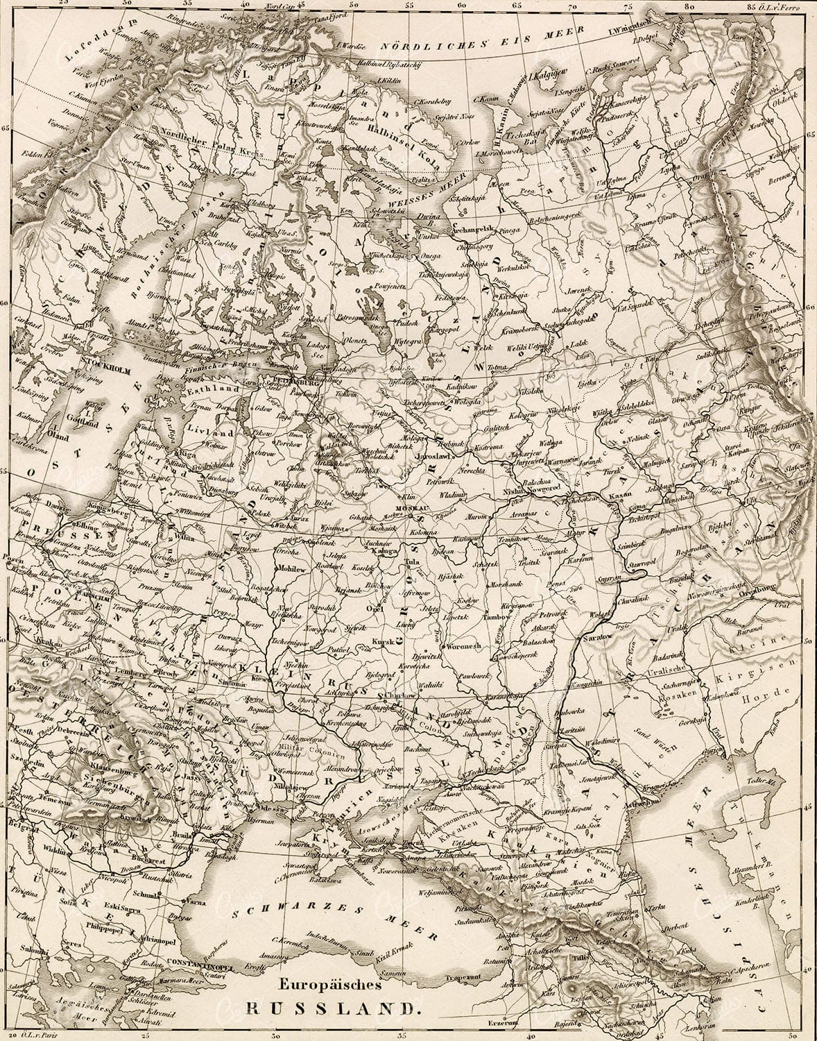
GEOGRAPHY – Map of Russia – Antique 1851 Print by Johann Heck
You’re looking at a well preserved original plate from Johann Georg Heck's “Iconographic Encyclopedia of Sciences, Literature and Art” published in 1851 by Rudolphe Garrigue in New York. We were extremely fortunate to acquire the full collection of illustrative prints from the series, which after many months of looking, proved to be very difficult!
- License Info
- Resolution: 7296 x 9287 300dpi
- Year of Print: 1851
- Artist: Johann Georg Heck
From this collection

ANTIQUE Map 1877 – Ethnographic map of Austria-Hungary
- License Info
- Resolution: 11523px x 8681px
- Year of Print: 1877
Related Images
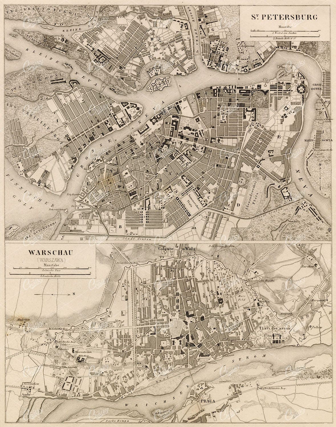
GEOGRAPHY – St. Petersburg, Warsaw – Antique 1851 Print by J. Heck
You’re looking at a well preserved original plate from Johann Georg Heck's “Iconographic Encyclopedia of Sciences, Literature and Art” published in 1851 by Rudolphe Garrigue in New York. We were extremely fortunate to acquire the full collection of illustrative prints from the series, which after many months of looking, proved to be very difficult!
- License Info
- Resolution: 7204 x 9163 300dpi
- Year of Print: 1851
- Artist: Johann Georg Heck
From this collection
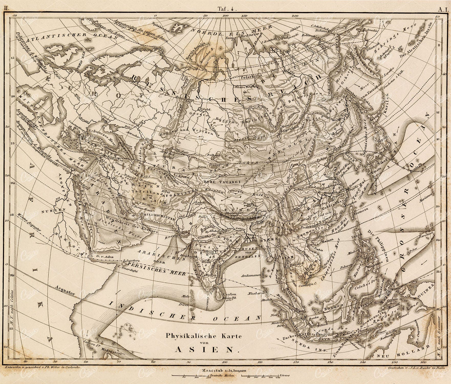
GEOGRAPHY and Planography – Map of Asia – Antique 1851 Print
You’re looking at a well preserved original plate from Johann Georg Heck's “Iconographic Encyclopedia of Sciences, Literature and Art” published in 1851 by Rudolphe Garrigue in New York. We were extremely fortunate to acquire the full collection of illustrative prints from the series, which after many months of looking, proved to be very difficult!
- License Info
- Resolution: 9371 x 7976 300dpi
- Year of Print: 1851
- Artist: Johann Georg Heck
From this collection

VINTAGE 1885 Map Showing the Scottish Highland Clans
- Resolution: 5676px x 8497px
- Year of Print: 1885
- Artist: William Melvin
Related Images


Meteorological Maps of Africa – Vintage German Print
- License Info
- Resolution: 6046px x 8870px
- Year of Print: 1877
Related Images
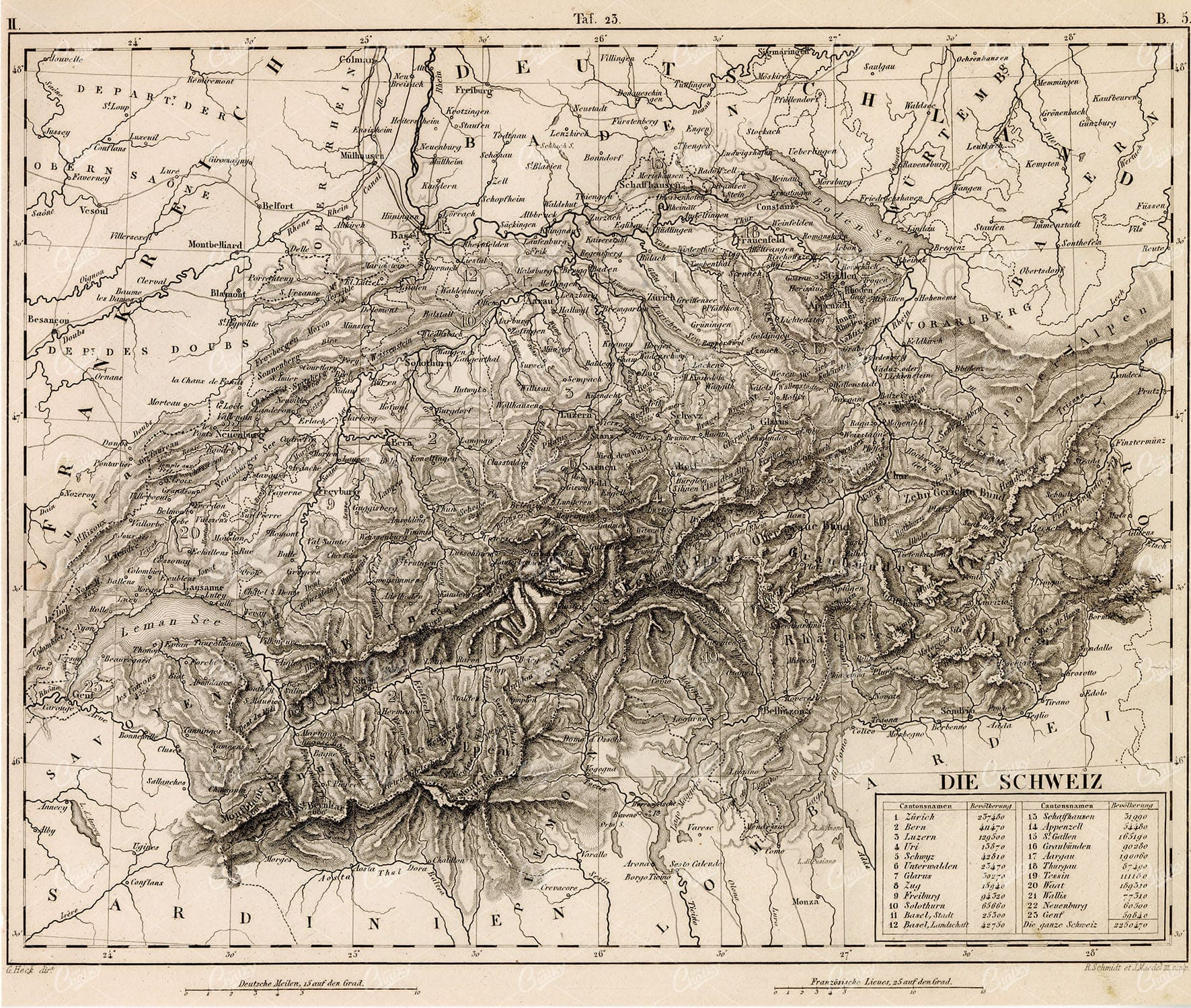
GEOGRAPHY – Map of Switzerland – Antique 1851 Print by Johann Heck
You’re looking at a well preserved original plate from Johann Georg Heck's “Iconographic Encyclopedia of Sciences, Literature and Art” published in 1851 by Rudolphe Garrigue in New York. We were extremely fortunate to acquire the full collection of illustrative prints from the series, which after many months of looking, proved to be very difficult!
- License Info
- Resolution: 9320 x 7893 300dpi
- Year of Print: 1851
- Artist: Johann Georg Heck
From this collection

Antique Map of Denmark Including Copenhagen, Faroe Islands, and Iceland Inset
An antique map of Denmark featuring detailed regional boundaries, major cities like Copenhagen, and insets of the Faroe Islands and Iceland. The map offers a historical view of Denmark's geography, including transportation routes and topographical details.
- Resolution: 7122 x 5100
- Image Type(s): JPG
From this collection

1877 Vintage Map – The Most Important Research Trips In Africa
- License Info
- Resolution: 8822px x 11610px
- Year of Print: 1877
Related Images
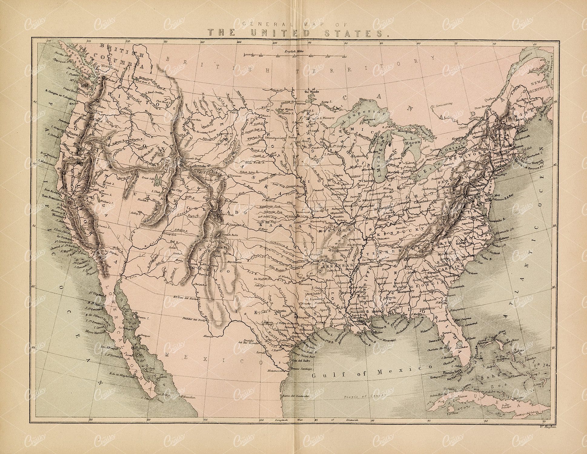
THE UNITED STATES – Antique Map – 1800’s Vintage Print
- License Info
- Resolution: 12037px x 9317px
- Year of Print: 1800's
Related Images

1882 Vintage Map of the Colonies of the European States
- License Info
- Resolution: 10762px x 8754px
- Year of Print: 1882
Related Images

Antique Map of Southern Missouri with Transportation Networks
An antique map of Southern Missouri detailing transportation networks, including railroads and highways, alongside topographical features from the early 20th century.
- Resolution: 7169 x 5100
- Image Type(s): JPG
From this collection

VINTAGE Map 1800’s – Traffic Map of Europe
- License Info
- Resolution: 11661px x 8733px
- Year of Print: 1800's
Related Images
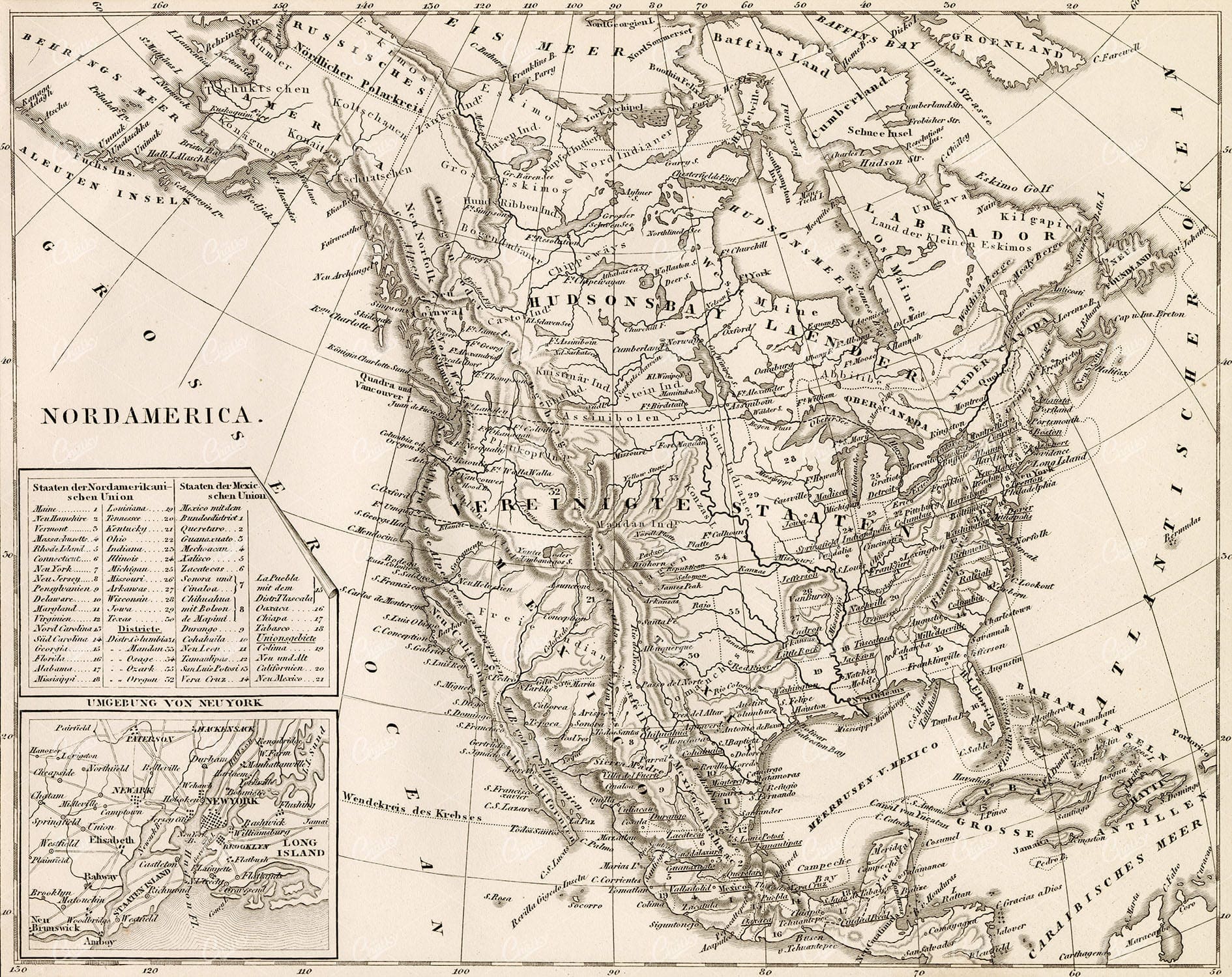
VINTAGE Map of North America – Antique German Print 1877
- License Info
- Resolution: 6016px x 8810px
- Year of Print: 1877
Related Images
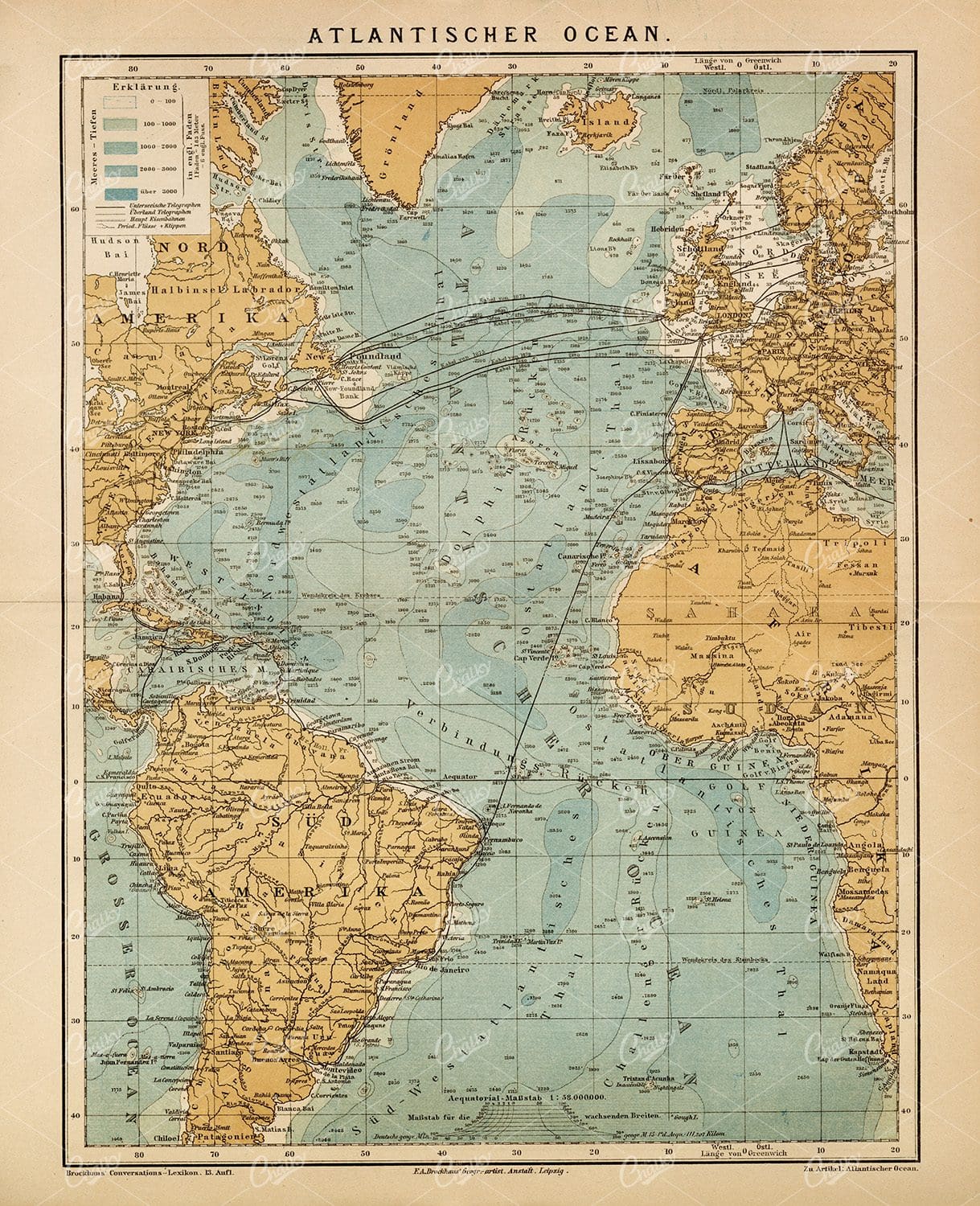
ANTIQUE Map of the Atlantic Ocean – Old 1882 Encyclopedia Print
- License Info
- Resolution: 5533px x 8818px
- Year of Print: 1882
Related Images
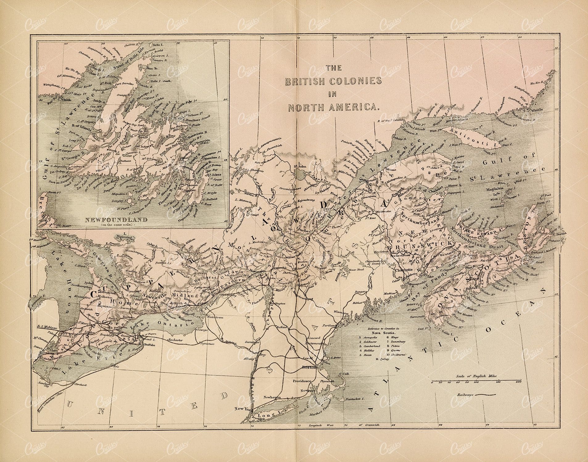
VINTAGE Map of The British Colonies in North America – 1800’s
- License Info
- Resolution: 11951px x 9405px
- Year of Print: 1800's
Related Images
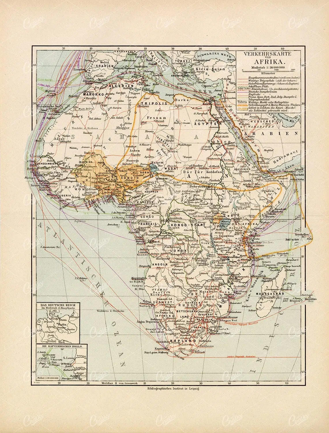
VINTAGE 1877 Print – Traffic Map Of Africa
- License Info
- Resolution: 8865px x 11651px
- Year of Print: 1877
Related Images

VINTAGE Map of Explorations in Australia – Antique print 1877
- License Info
- Resolution: 8789px x 5980px
- Year of Print: 1877
Related Images

Support the Library
Our supporters and members help us continue collecting and restoring these wonderful pieces of art for the modern creator
Unlock Everything and Become a Member!
While a lot of the library is available for free, some is kept behind closed dusty doors only to be accessed by our lovely members.