

Vintage Map of Montana
An antique map showcasing the state of Montana, highlighting counties, cities, and geographical features in fine detail, typical of late 19th to early 20th century cartography.
- Resolution: 7235 x 5100
- Image Type(s): JPG
From this collection
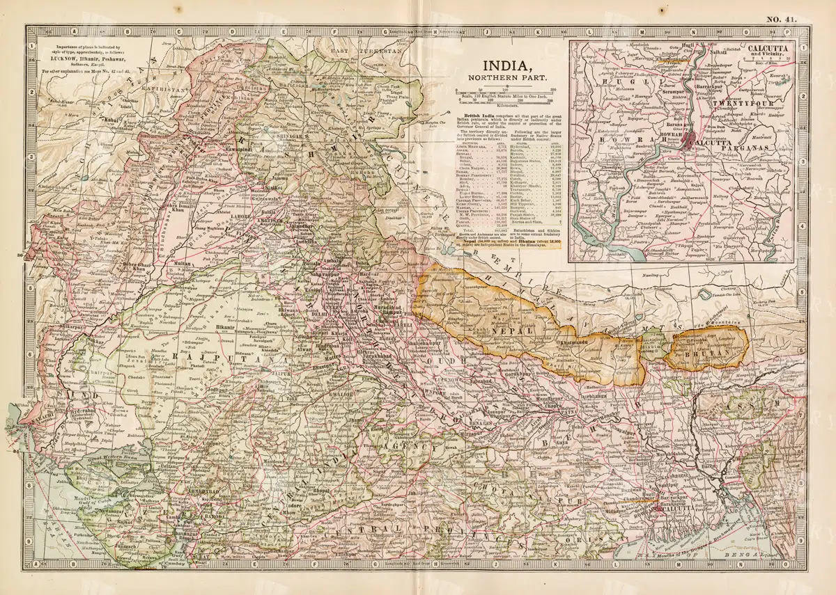
Historical Map of Northern India and Nepal Featuring Mountainous Terrain
Historical Map of Northern India and Nepal Featuring Mountainous Terrain
- Resolution: 7144 x 5100
- Image Type(s): JPG
- Antique
- antique map
- Atlas
- cartography
- cities
- colonial
- early 20th century
- exploration
- Geography
- Globe
- Himalayas
- historical
- historical geography
- historical map
- History
- Landscape
- Map
- mountainous terrain
- Navigation
- Nepal
- Northern India
- old
- old map
- political boundaries
- representation
- Rivers
- South Asia
- South Asian history
- topography
- transportation
- World
From this collection

Historical Map of Idaho and Wyoming Including Yellowstone National Park
This historical map covers the states of Idaho and Wyoming, with a special focus on Yellowstone National Park. The map details the topographical features, including mountains, rivers, and forests, as well as the transportation routes and political boundaries of the early 20th century. It provides a valuable snapshot of the American West during this period, highlighting the natural beauty and geographical diversity of the region.
- Resolution: 7141 x 5100
- Image Type(s): JPG
- American West
- Antique
- antique map
- cartography
- conservation
- early 20th century
- exploration
- forests
- Geography
- historical
- historical geography
- historical map
- History
- Idaho
- Landscape
- Map
- Mountains
- national parks
- old
- old map
- political boundaries
- representation
- Rivers
- topography
- transportation
- United States
- vintage
- Western states
- Wyoming
- Yellowstone National Park
From this collection

Detailed 19th Century Map of Illinois, USA
A richly detailed 19th century map of Illinois, focusing on the southern part of the state, including the area around Chicago and St. Louis. The map is intricately detailed with towns, railways, and geographical features, showcasing the state’s development during the period.
- Resolution: 7265 x 5100
- Image Type(s): JPG
- St. Louis
- southern Illinois
- archives
- reference
- territorial
- topographic
- USA
- development
- settlements
- Midwest
- topography
- antique map
- exploration
- old map
- cartography
- transportation
- railways
- counties
- landmarks
- towns
- historic
- 19th-century
- historical
- heritage
- urban
- country
- vintage
- retro
- representation
- Antique
- Rural
- History
- Chicago
- Illinois
- Geography
- Atlas
- World
- Engineering
- America
- Rivers
- Map
- Borders
From this collection

Antique 19th Century Map of Southern Ohio Featuring Major Cities and Rivers
A detailed 19th-century map showcasing Southern Ohio, highlighting cities like Cincinnati and Cleveland, along with rivers and other key geographical features. Ideal for historical and geographical studies.
- Resolution: 7248 x 5100
- Image Type(s): JPG
From this collection

19th Century Map of South Dakota with County Divisions
A detailed 19th century map of South Dakota, showcasing the state's counties, cities, and geographical features. This vintage map offers insight into the political and territorial divisions of the era, with intricate details of rivers and topography.
- Resolution: 7264 x 5100
- Image Type(s): JPG
- 1800s
- 19th-century
- American history
- antique cartography
- antique map
- antique paper
- archival
- cartographic history
- cartography
- cities
- county divisions
- geographical features
- Geography
- heritage
- historical artifact
- historical document
- historical geography
- historical information
- historical map
- historical records
- history lovers
- Map
- map of South Dakota
- old map
- old South Dakota
- Plan
- political divisions
- representation
- South Dakota
- state map
- territorial divisions
- topography
- United States
- vintage
- vintage map
From this collection
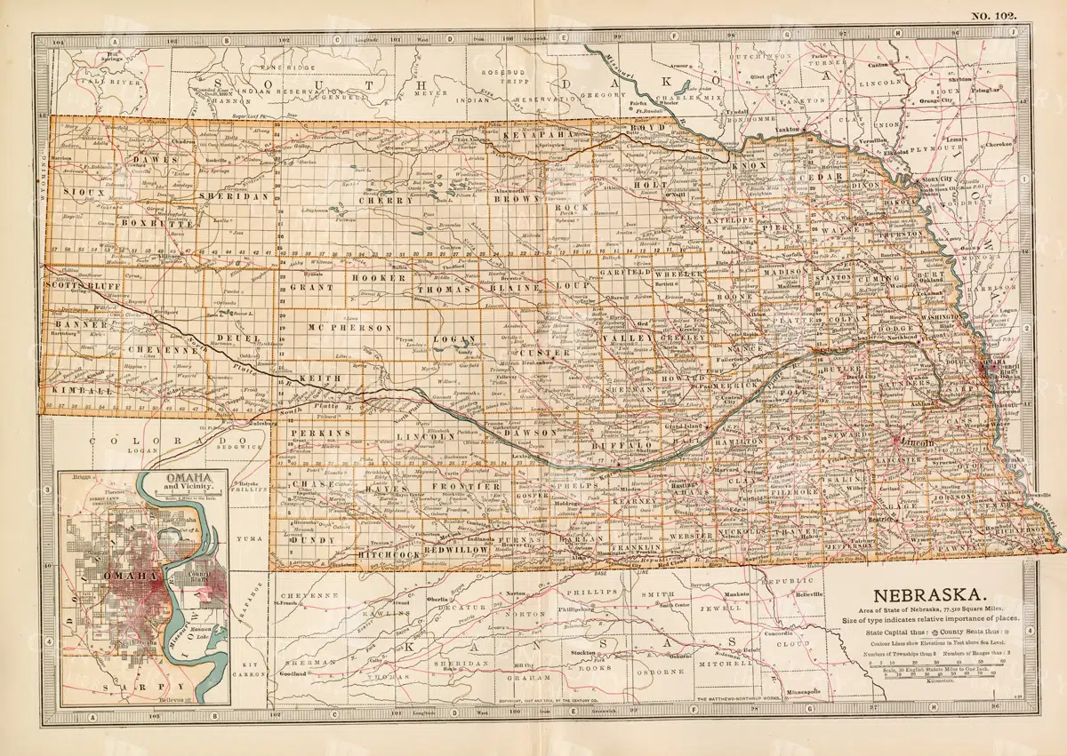
Historic Map of Nebraska
A detailed historic map of Nebraska, illustrating counties, towns, and important routes, reflecting the geography and infrastructure of the state during the late 19th to early 20th century.
- Resolution: 7236 x 5100
- Image Type(s): JPG
From this collection

Antique Map of North Dakota
A historic map of North Dakota from the late 19th century, detailing the state's counties, cities, and major geographical landmarks, reflecting its development and settlement patterns.
- Resolution: 7244 x 5100
- Image Type(s): JPG
From this collection

Vintage 1800s Map of Arizona and New Mexico Showing Territorial Boundaries and Natural Features – Antique Map
This vintage map from the 1800s depicts Arizona and New Mexico, highlighting territorial boundaries and natural features. The antique map offers a historical view of the region's geography during a formative period in its history, with intricate details of the landscape and settlements. Ideal for history buffs and map collectors.
- Resolution: 7107 x 5100
- Image Type(s): JPG
- 1800s
- American history
- American West
- Antique
- antique map
- Arizona
- Arizona map
- cartography
- colonial era
- detailed
- exploration
- Geography
- historical
- historical map
- journal
- Map
- natural features
- New Mexico
- New Mexico map
- old map
- political map
- preserved
- regional history
- representation
- retro
- territorial boundaries
- topography
- vintage
- vintage map
From this collection

Antique 1800s Map of Central Africa Featuring Colonial Territories and Natural Features – Vintage Historical Map
This detailed antique map from the 1800s depicts Central Africa, highlighting various colonial territories, natural features, and historical locations. It showcases the intricate geography of the region during the colonial period, offering a glimpse into the past through this vintage, beautifully preserved map.
- Resolution: 7100 x 5100
- Image Type(s): JPG
- 1800s
- Africa
- Africa colonial
- Africa map
- Antique
- antique illustration
- Atlas
- Borders
- cartography
- Central Africa
- colonial
- colonialism
- detailed
- exploration
- Geography
- historical
- historical map
- History
- illustration
- Map
- Mountains
- natural features
- old map
- past
- preserved
- regions
- representation
- retro
- Rivers
- territories
- topography
- vintage
- vintage map
- World
From this collection

Antique Map of Denmark Including Copenhagen, Faroe Islands, and Iceland Inset
An antique map of Denmark featuring detailed regional boundaries, major cities like Copenhagen, and insets of the Faroe Islands and Iceland. The map offers a historical view of Denmark's geography, including transportation routes and topographical details.
- Resolution: 7122 x 5100
- Image Type(s): JPG
From this collection

Support the Library
Our supporters and members help us continue collecting and restoring these wonderful pieces of art for the modern creator
Unlock Everything and Become a Member!
While a lot of the library is available for free, some is kept behind closed dusty doors only to be accessed by our lovely members.