

Historic Map of Oceanica Including Australia, New Zealand, and Pacific Islands
An extensive historical map of Oceanica, encompassing Australia, New Zealand, and various Pacific Islands. This 19th-century map details major routes, colonial regions, and key geographical features.
- Resolution: 7246 x 5100
- Image Type(s): JPG
From this collection

Eighteenth Century Gentlemen in Conversation with Clerical Figure Illustration
A Charming Mix of Vintage Illustrations – Pastoral Scenes, Mythical Figures & More This image is part of a collection packed with beautifully restored vintage toile de jouy style illustrations. Think peaceful countryside scenes, graceful mythological figures, farm animals, and a good dose of that old-timey charm. Whether you’re into junk journaling, crafting, branding, or just love adding a touch of vintage to your creative projects, there’s loads to play with here. You’ll find everything from shepherd boys and garden goddesses to hot air balloons, dancing villagers, and elegant birds - all cleaned up and ready to use. Perfect for print, digital, or anything in between, this set brings a slice of history into your modern designs with plenty of character and detail.
- Image Type(s): PNG
From this collection

Detailed Historical Map of the East India Islands Including Malaysia and the Philippines
A detailed historical map of the East India Islands, including regions like Malaysia, the Philippines, and New Guinea. The map highlights important geographical features, cities, and maritime routes, offering a glimpse into the region's colonial history.
- Resolution: 7123 x 5100
- Image Type(s): JPG
From this collection

Antique 1800s Map of North-West Africa Highlighting Morocco, Algeria, and Western Sahara – Vintage Historical Map
This antique map from the 1800s highlights North-West Africa, including Morocco, Algeria, and the Western Sahara. It captures the colonial and geographical landscape of the time, showing intricate details of the region’s political boundaries and natural features. A beautifully preserved piece of history in vintage cartography.
- Resolution: 7102 x 5100
- Image Type(s): JPG
- 1800s
- Africa
- Africa colonial
- Africa map
- Algeria
- Antique
- antique map
- Atlas
- cartography
- colonial
- colonial era
- country
- detailed
- exploration
- Geography
- Globe
- historical
- historical map
- History
- Map
- Morocco
- natural features
- Navigation
- North-West Africa
- old
- old map
- political boundaries
- preserved
- representation
- retro
- topography
- Travel
- vintage
- vintage map
- Western Sahara
- World
From this collection

Antique Map of Eastern India, Burma, Siam, and French Indo-China
This antique map showcases Eastern India, Burma (now Myanmar), Siam (now Thailand), and French Indo-China (Vietnam, Laos, Cambodia), with a focus on the geopolitical boundaries and major cities of the early 20th century. The map provides a detailed view of the region's topographical features, including rivers, mountain ranges, and coastlines, reflecting the historical context of Southeast Asia during this period.
- Resolution: 7143 x 5100
- Image Type(s): JPG
- Antique
- antique map
- Asia
- Atlas
- Burma
- cartography
- cities
- coastlines
- colonial
- country
- cultural heritage
- early 20th century
- Eastern India
- exploration
- French Indo-China
- Geography
- geopolitical boundaries
- historical geography
- historical map
- History
- Landscape
- Map
- mountain ranges
- old map
- representation
- Rivers
- Siam
- Southeast Asia
- topography
- World
From this collection

Vintage Map of Minnesota Featuring Lakes and Urban Areas
A vintage map of Minnesota highlighting its numerous lakes, urban areas, and transportation routes, showcasing the state's geographical diversity from the early 20th century.
- Resolution: 7166 x 5100
- Image Type(s): JPG
From this collection

Antique Map of Mexico Showing Topography and Major Cities
An antique map of Mexico displaying the topography, major cities, and transportation routes, with a focus on the geographical diversity and historical boundaries from the early 20th century.
- Resolution: 7163 x 5100
- Image Type(s): JPG
From this collection

Vintage Map of Massachusetts and Surrounding Regions
A vintage map of Massachusetts showing detailed topography, cities, and transportation networks, including an inset of the Boston metropolitan area from the early 20th century.
- Resolution: 7162 x 5100
- Image Type(s): JPG
From this collection

Antique Map of New Brunswick, Nova Scotia, and Prince Edward Island
A historic map from the late 19th century illustrating the Canadian provinces of New Brunswick, Nova Scotia, and Prince Edward Island, featuring key cities, towns, and geographical landmarks.
- Resolution: 7238 x 5100
- Image Type(s): JPG
- 19th-century
- Antique
- Atlantic
- Atlas
- Borders
- Canada
- cartography
- cities
- classic
- coastline
- colonial
- country
- Geography
- Globe
- heritage
- History
- illustration
- Landscape
- Map
- maritime
- new brunswick
- novascotia
- Ocean
- princeed ward island
- provinces
- regions
- representation
- Rivers
- Road
- settlements
- territory
- topography
- tourism
- towns
- Travel
- vintage
- World
From this collection

Vintage 1800s Map of Southern Africa Including South Africa, Namibia, and Surrounding Territories – Antique Map
A vintage map from the 1800s depicting Southern Africa, including South Africa, Namibia, and surrounding territories. This antique map highlights the region’s colonial borders, cities, and natural features, offering a detailed view of the area during the colonial period. Perfect for history and cartography enthusiasts.
- Resolution: 7103 x 5100
- Image Type(s): JPG
From this collection

Antique Map of Southern Michigan and Urban Development
An antique map of Southern Michigan detailing urban development, major cities, and transportation networks, including Detroit, from the early 20th century.
- Resolution: 7165 x 5100
- Image Type(s): JPG
From this collection

Historical Map of Manitoba, British Columbia, and the Northwest Territories
A detailed historical map depicting the regions of Manitoba, British Columbia, and the Northwest Territories, showcasing topographical features, settlements, and boundaries in the early 20th century.
- Resolution: 7160 x 5100
- Image Type(s): JPG
- 20th
- Antique
- Atlas
- Borders
- boundaries
- British
- Canada
- cartography
- century
- climate
- coastline
- colonial
- columbia
- demographics
- division
- early
- exploration
- Geography
- Globe
- historical
- History
- infrastructure
- Landscape
- manitoba
- Map
- natural
- northwest
- provincial
- regions
- representation
- resources
- River
- settlement
- settlements
- territories
- topographical
- transportation
- Travel
- vintage
- World
From this collection

Historical Map of Northern Michigan and Surrounding Great Lakes
A historical map of Northern Michigan, including surrounding areas of the Great Lakes, highlighting major towns, transportation routes, and natural features from the early 20th century.
- Resolution: 7164 x 5100
- Image Type(s): JPG
From this collection

Antique Map of Maryland and Delaware with Washington D.C.
An antique map highlighting Maryland and Delaware, including insets of Washington D.C. and Baltimore, featuring roads, rivers, and county lines from the late 19th to early 20th century.
- Resolution: 7161 x 5100
- Image Type(s): JPG
- 19th
- 20th
- administrative
- American
- Antique
- Atlas
- Baltimore
- boundaries
- Capital
- cartography
- century
- City
- colonial
- county
- dc
- Delaware
- development
- early
- Geography
- heritage
- historic
- History
- infrastructure
- landmarks
- late
- Lines
- Map
- Maryland
- political
- regional
- representation
- Rivers
- Roads
- transportation
- urban
- urbanization
- vintage
- Washington
- World
From this collection
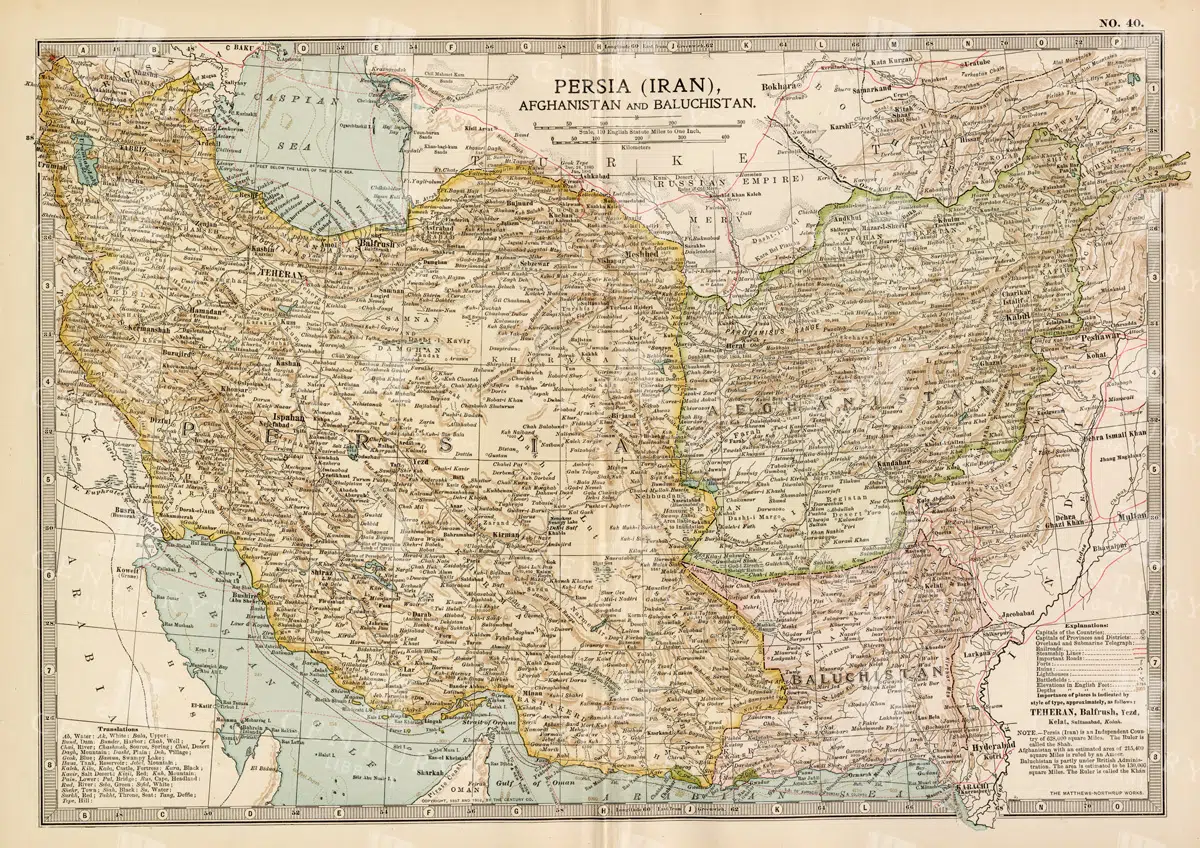
Antique Map of Persia, Afghanistan, and Baluchistan with Geopolitical Borders
This antique map of Persia (modern-day Iran), Afghanistan, and Baluchistan highlights the geopolitical borders and key cities of the early 20th century. The map details the region's topographical features, including mountain ranges, rivers, and deserts, offering a comprehensive view of the landscape. It provides a historical perspective on the political and geographical divisions in this part of the Middle East and South Asia during the period.
- Resolution: 7148 x 5100
- Image Type(s): JPG
- Afghanistan
- Afghanistan history
- Antique
- antique map
- Atlas
- Baluchistan
- cartography
- cities
- colonial
- country
- deserts
- early 20th century
- exploration
- Geography
- geopolitical borders
- historical geography
- historical map
- History
- Iran
- Landscape
- Map
- Middle East
- mountain ranges
- old map
- Persia
- Persia history
- representation
- Rivers
- South Asia
- topography
- World
From this collection

Antique 1800s Map of Arabia, Oman, and Aden Including the Arabian Peninsula – Vintage Historical Map
This antique map from the 1800s illustrates the Arabian Peninsula, including Arabia, Oman, and Aden. The vintage map highlights the region's historical geography, boundaries, and important cities, offering a detailed view of the area during the colonial period. A valuable resource for those interested in Middle Eastern history and cartography.
- Resolution: 7106 x 5100
- Image Type(s): JPG
From this collection
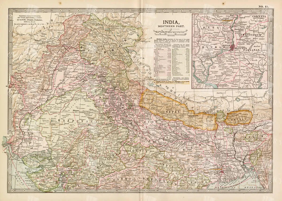
Historical Map of Northern India and Nepal Featuring Mountainous Terrain
Historical Map of Northern India and Nepal Featuring Mountainous Terrain
- Resolution: 7144 x 5100
- Image Type(s): JPG
- Antique
- antique map
- Atlas
- cartography
- cities
- colonial
- early 20th century
- exploration
- Geography
- Globe
- Himalayas
- historical
- historical geography
- historical map
- History
- Landscape
- Map
- mountainous terrain
- Navigation
- Nepal
- Northern India
- old
- old map
- political boundaries
- representation
- Rivers
- South Asia
- South Asian history
- topography
- transportation
- World
From this collection

East India Company Vintage Heraldry Naval Flag
A vintage line art illustration of the East India Company naval flag, depicting historical heraldry elements associated with maritime trade and colonial history.
- Image Type(s): PNG
Related Images

Vintage Map of Missouri, Northern Part with Cities and Roads
A vintage map showing the northern part of Missouri, including cities, roads, and county lines, reflecting the region's infrastructure and geography from the early 20th century.
- Resolution: 7168 x 5100
- Image Type(s): JPG
From this collection

Antique 1800s Map of Central Africa Featuring Colonial Territories and Natural Features – Vintage Historical Map
This detailed antique map from the 1800s depicts Central Africa, highlighting various colonial territories, natural features, and historical locations. It showcases the intricate geography of the region during the colonial period, offering a glimpse into the past through this vintage, beautifully preserved map.
- Resolution: 7100 x 5100
- Image Type(s): JPG
- 1800s
- Africa
- Africa colonial
- Africa map
- Antique
- antique illustration
- Atlas
- Borders
- cartography
- Central Africa
- colonial
- colonialism
- detailed
- exploration
- Geography
- historical
- historical map
- History
- illustration
- Map
- Mountains
- natural features
- old map
- past
- preserved
- regions
- representation
- retro
- Rivers
- territories
- topography
- vintage
- vintage map
- World
From this collection

Antique Map of Mississippi with River and County Details
An antique map of Mississippi focusing on its river systems, county divisions, and major transportation routes, reflecting the state's historical geography from the early 20th century.
- Resolution: 7167 x 5100
- Image Type(s): JPG
From this collection

Support the Library
Our supporters and members help us continue collecting and restoring these wonderful pieces of art for the modern creator
Unlock Everything and Become a Member!
While a lot of the library is available for free, some is kept behind closed dusty doors only to be accessed by our lovely members.