

Vintage Map of Southern England and Wales Highlighting Major Cities and Coastal Areas
This vintage map of Southern England and Wales highlights major cities, coastal areas, and important transportation routes. The map provides detailed insights into the region's historical geography and urban development during the period.
- Resolution: 7127 x 5100
- Image Type(s): JPG
From this collection

Central Europe Travel Map Featuring Major Cities Like Paris, Berlin, and Vienna
This travel map of Central Europe highlights major cities such as Paris, Berlin, and Vienna, showcasing detailed routes and geographical features. The map provides a glimpse into the historical and political landscape of Central Europe during the time.
- Resolution: 7117 x 5100
- Image Type(s): JPG
From this collection

Detailed Historical Map of the East India Islands Including Malaysia and the Philippines
A detailed historical map of the East India Islands, including regions like Malaysia, the Philippines, and New Guinea. The map highlights important geographical features, cities, and maritime routes, offering a glimpse into the region's colonial history.
- Resolution: 7123 x 5100
- Image Type(s): JPG
From this collection
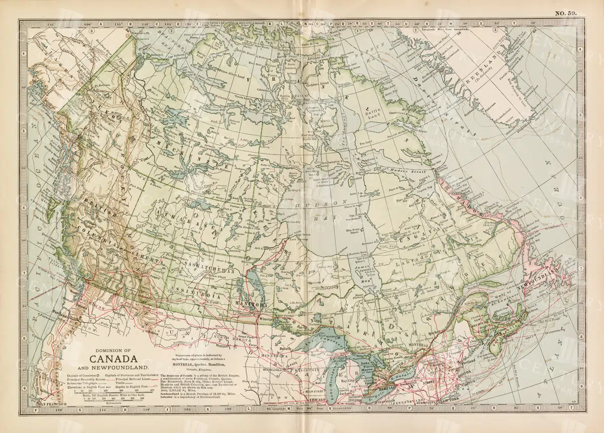
Antique Map of Canada and Newfoundland Highlighting Major Cities and Natural Features
An antique map of Canada and Newfoundland, offering a detailed look at the region's cities, natural landmarks, and geographical features. The map provides insights into the historical significance of the area during the time of its creation.
- Resolution: 7115 x 5100
- Image Type(s): JPG
From this collection

Antique Line Art of a Sivathere Skull with Distinct Features
A line art illustration of a Sivathere skull, showcasing its unique prehistoric features with fine details and traditional engraving style
- Resolution: 3139px x 2191px
- Image Type(s): PNG
From this collection

Vintage Map of Southern England Including London, Brighton, and Major Coastal Cities
A vintage map of Southern England, highlighting major cities like London and Brighton, as well as coastal areas. The map provides detailed insights into the region's historical geography, transportation routes, and urban development.
- Resolution: 7129 x 5100
- Image Type(s): JPG
From this collection

Antique Map of Western England and Wales Including Detailed Regional Boundaries
An antique map of Western England and Wales, showcasing detailed regional boundaries and cities like Liverpool and Manchester. The map highlights important geographical features, transportation routes, and historical landmarks in the area.
- Resolution: 7126 x 5100
- Image Type(s): JPG
From this collection

Detailed Vintage Map of Central America Including Guatemala and Nicaragua
A detailed vintage map of Central America, featuring countries like Guatemala and Nicaragua. The map highlights important geographical features, cities, and transportation routes, providing a historical perspective on the region.
- Resolution: 7116 x 5100
- Image Type(s): JPG
From this collection

Vintage Map of Northern England and Wales Highlighting Major Cities and Geographic Features
A vintage map of Northern England and Wales, detailing major cities, towns, and geographical features. The map includes important transportation routes and provides a historical overview of the region during the period.
- Resolution: 7125 x 5100
- Image Type(s): JPG
From this collection

Vintage Map of Eastern China with Detailed Regions and Cities like Beijing and Shanghai
A vintage map of Eastern China, detailing major cities such as Beijing and Shanghai. The map provides insights into the region's geography, transportation networks, and historical context, offering a comprehensive view of Eastern China's layout.
- Resolution: 7118 x 5100
- Image Type(s): JPG
From this collection

Historical Map of Northern Michigan and Surrounding Great Lakes
A historical map of Northern Michigan, including surrounding areas of the Great Lakes, highlighting major towns, transportation routes, and natural features from the early 20th century.
- Resolution: 7164 x 5100
- Image Type(s): JPG
From this collection

Antique Historical Map of Western Austria-Hungary Featuring Vienna and Prague
An antique map of the western part of Austria-Hungary, highlighting major cities like Vienna and Prague. The map provides intricate details of regional boundaries, railway networks, and topographical features, reflecting the historical political landscape of the region.
- Resolution: 7111 x 5100
- Image Type(s): JPG
From this collection

Antique Map of the Chinese Empire Highlighting Major Regions and Cities
This antique map of the Chinese Empire highlights the major regions and cities, offering a detailed view of the empire's geographical and political structure. The map also includes insets of significant areas like Hong Kong and Peking, providing historical context.
- Resolution: 7119 x 5100
- Image Type(s): JPG
From this collection

Antique Illustration of a Bornean Whip-Scorpion with Detailed Body Features from the 1800s
This vintage illustration from the 1800s showcases a Bornean whip-scorpion with detailed body features, highlighting its unique pincers and elongated tail.
- Resolution: 2738px x 4173px
- Image Type(s): PNG
Related Images

Side Profile of a Chimpanzee
A side profile illustration of a chimpanzee, highlighting its distinctive facial features and fur texture. This vintage style artwork showcases the chimp's thoughtful expression and the intricate details of its anatomy.
- Resolution: 4081px x 3629px
- Image Type(s): PNG
Related Images

Front View of a Chimpanzee
A detailed illustration of a chimpanzee's face, showcasing its expressive features and textured fur in a classic etching style. The artwork captures the intelligence and emotion often associated with these primates.
- Resolution: 4549px x 3585px
- Image Type(s): PNG
Related Images
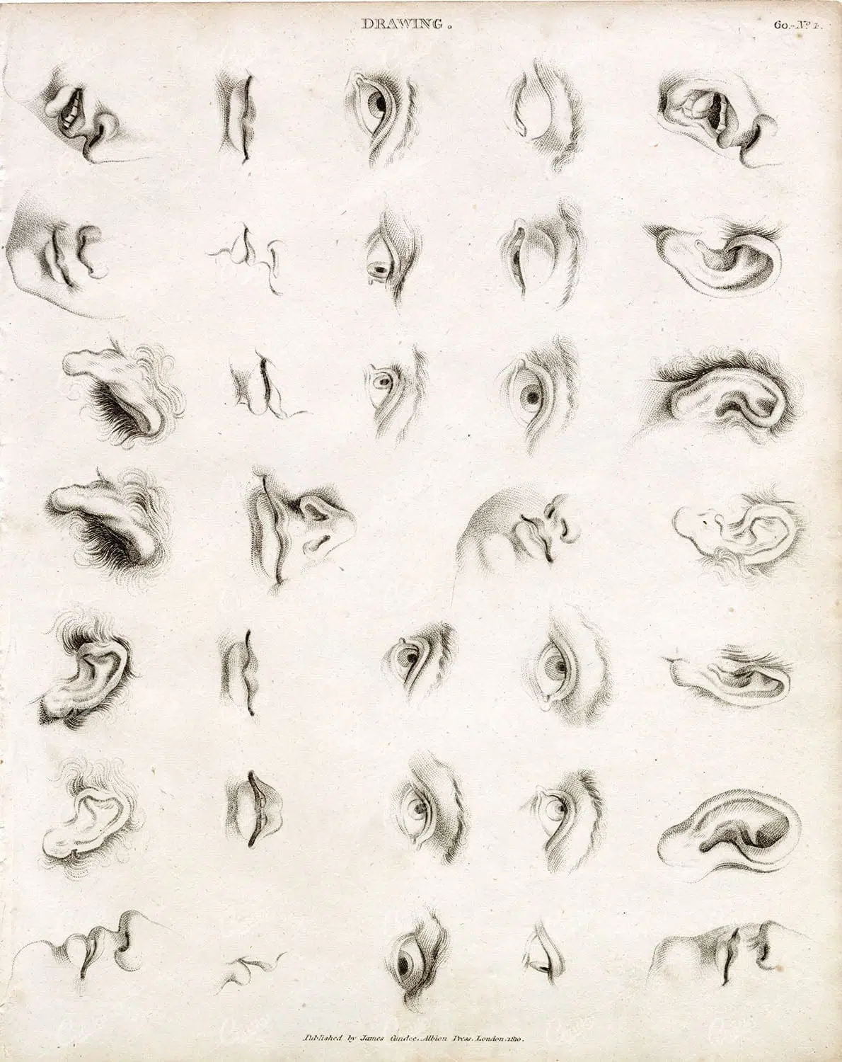
ANTIQUE Guide to Drawing Facial Features – Abraham REES 1800s Plate
You're looking at an Original pre-1820's Antique Engraving from a rare copy of Abraham Rees' "The Cyclopaedia; or, UNIVERSAL DICTIONARY OF ARTS, SCIENCES, and LITERATURE" (Published 1820 by Longman, Hurst, Rees, Orme)
- License Info
- Resolution: 7400 x 9350 300dpi
- Year of Print: 1800s
- Artist: Abraham Rees
From this collection

Detailed Antique Map of Colorado Highlighting Major Cities and Geographic Features
An antique map of Colorado, showcasing major cities, counties, and detailed geographic features. The map includes railway lines, mountain ranges, and towns, providing a historical perspective on Colorado's development during the time.
- Resolution: 7120 x 5100
- Image Type(s): JPG
From this collection

Vintage Map of Connecticut and Rhode Island Including Major Cities and Coastal Features
A vintage map depicting Connecticut and Rhode Island, highlighting major cities, towns, and coastal features. The map provides detailed insights into the region's transportation routes, geographical features, and historical importance during the period.
- Resolution: 7121 x 5100
- Image Type(s): JPG
From this collection

Antique Map of Southern Missouri with Transportation Networks
An antique map of Southern Missouri detailing transportation networks, including railroads and highways, alongside topographical features from the early 20th century.
- Resolution: 7169 x 5100
- Image Type(s): JPG
From this collection

Support the Library
Our supporters and members help us continue collecting and restoring these wonderful pieces of art for the modern creator
Unlock Everything and Become a Member!
While a lot of the library is available for free, some is kept behind closed dusty doors only to be accessed by our lovely members.