
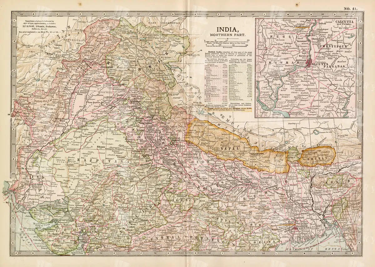
Historical Map of Northern India and Nepal Featuring Mountainous Terrain
Historical Map of Northern India and Nepal Featuring Mountainous Terrain
- Resolution: 7144 x 5100
- Image Type(s): JPG
- Antique
- antique map
- Atlas
- cartography
- cities
- colonial
- early 20th century
- exploration
- Geography
- Globe
- Himalayas
- historical
- historical geography
- historical map
- History
- Landscape
- Map
- mountainous terrain
- Navigation
- Nepal
- Northern India
- old
- old map
- political boundaries
- representation
- Rivers
- South Asia
- South Asian history
- topography
- transportation
- World
From this collection
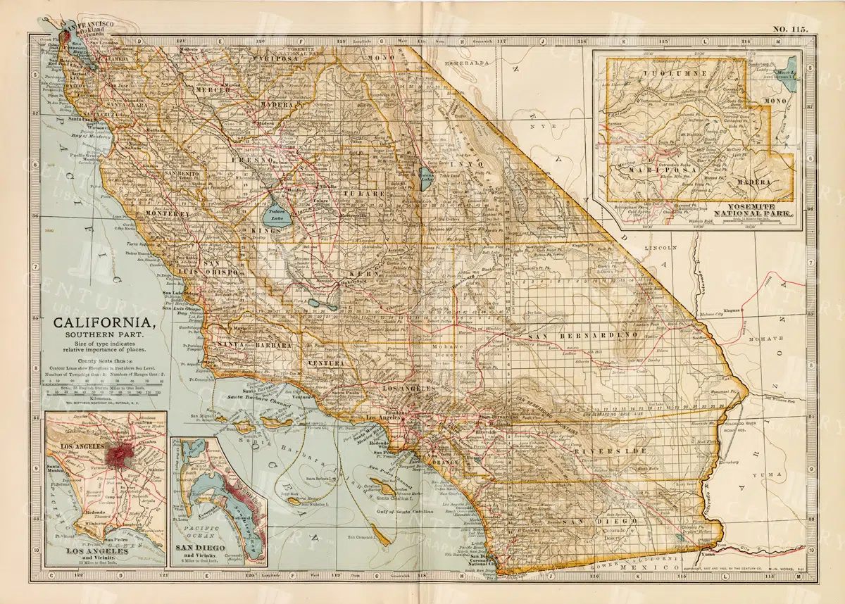
Vintage Map of Southern California Featuring Los Angeles and San Diego
This vintage map showcases the southern part of California, including major cities like Los Angeles and San Diego. The map highlights important transportation routes, natural landmarks, and the region's historical and geographical features.
- Resolution: 7114 x 5100
- Image Type(s): JPG
From this collection

Antique 1800s Map of Arkansas with Detailed County Lines and Natural Features – Vintage Historical Cartography
An antique map from the 1800s showcasing Arkansas, with detailed county lines and natural features. This vintage map provides a historical view of Arkansas’s geography during the 19th century, offering a beautifully preserved piece of the state’s cartographic history.
- Resolution: 7108 x 5100
- Image Type(s): JPG
From this collection

Detailed 19th Century Map of Illinois, USA
A richly detailed 19th century map of Illinois, focusing on the southern part of the state, including the area around Chicago and St. Louis. The map is intricately detailed with towns, railways, and geographical features, showcasing the state’s development during the period.
- Resolution: 7265 x 5100
- Image Type(s): JPG
- 19th-century
- America
- Antique
- antique map
- archives
- Atlas
- Borders
- cartography
- Chicago
- counties
- country
- development
- Engineering
- exploration
- Geography
- heritage
- historic
- historical
- History
- Illinois
- landmarks
- Map
- Midwest
- old map
- railways
- reference
- representation
- retro
- Rivers
- Rural
- settlements
- southern Illinois
- St. Louis
- territorial
- topographic
- topography
- towns
- transportation
- urban
- USA
- vintage
- World
From this collection

Antique 19th Century Map of Southern Ohio Featuring Major Cities and Rivers
A detailed 19th-century map showcasing Southern Ohio, highlighting cities like Cincinnati and Cleveland, along with rivers and other key geographical features. Ideal for historical and geographical studies.
- Resolution: 7248 x 5100
- Image Type(s): JPG
From this collection

Heraldic Salamander in Flames Vintage Illustration
An isolated PNG image of a salamander engulfed in flames, rendered in a vintage heraldic style. This mythical creature is often associated with fire, transformation, and resilience in heraldic traditions. Perfect for use in designs that explore mythological or alchemical themes.
- Resolution: 1022 x 795
- Image Type(s): PNG
Related Images

Heraldic Swan in Vintage Medieval Style
An isolated PNG image of a swan, rendered in a vintage medieval style. The swan is detailed with elegant plumage and a regal posture, often representing purity, grace, and nobility in heraldic traditions. This illustration is perfect for adding a touch of classic elegance to any design project.
- Resolution: 1428 x 1799
- Image Type(s): PNG
Related Images

Historical Map of Idaho and Wyoming Including Yellowstone National Park
This historical map covers the states of Idaho and Wyoming, with a special focus on Yellowstone National Park. The map details the topographical features, including mountains, rivers, and forests, as well as the transportation routes and political boundaries of the early 20th century. It provides a valuable snapshot of the American West during this period, highlighting the natural beauty and geographical diversity of the region.
- Resolution: 7141 x 5100
- Image Type(s): JPG
- American West
- Antique
- antique map
- cartography
- conservation
- early 20th century
- exploration
- forests
- Geography
- historical
- historical geography
- historical map
- History
- Idaho
- Landscape
- Map
- Mountains
- national parks
- old
- old map
- political boundaries
- representation
- Rivers
- topography
- transportation
- United States
- vintage
- Western states
- Wyoming
- Yellowstone National Park
From this collection

Antique Map of the Chinese Empire Highlighting Major Regions and Cities
This antique map of the Chinese Empire highlights the major regions and cities, offering a detailed view of the empire's geographical and political structure. The map also includes insets of significant areas like Hong Kong and Peking, providing historical context.
- Resolution: 7119 x 5100
- Image Type(s): JPG
From this collection

Archangel Michael Defeating the Devil Vintage Heraldry
A dramatic isolated PNG image of Archangel Michael defeating the devil, rendered in a vintage heraldic style. This powerful image is rich in symbolism, often representing the triumph of good over evil. Ideal for use in religious, historical, or mythological design projects.
- Resolution: 944 x 1231
- Image Type(s): PNG
Related Images
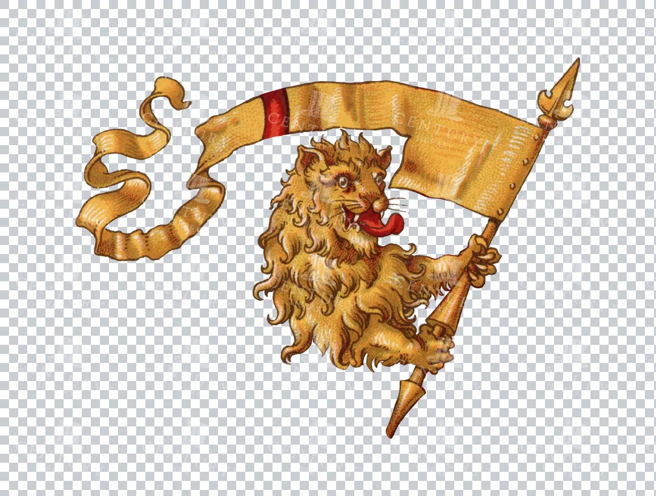
Vintage Heraldic Lion Holding a Banner Illustration
An isolated PNG image of a vintage heraldic lion holding a decorative banner. The lion is drawn in a classic style, often seen in traditional coats of arms. The banner flows gracefully, adding a sense of motion to the image. Perfect for historical, fantasy, or medieval-themed designs.
- Resolution: 2318 x 1754
- Image Type(s): PNG
Related Images

Ancient Greek or Persian Messenger Holding a Caduceus
This image is part of our Extensive Collection of 135 Greek, Roman, and Mythology Vintage Line Art Illustrations. Each piece hand-selected from a variety of 19th-century books and ephemera found within our private library.
- Image Type(s): PNG
From this collection

Decorative Floral Angel Banner with Floral Wreath Draped Below and Cherubs Sat on Top with Oak Leaf Background within Banner Frame
A vintage decorative banner illustration featuring cherubs sitting atop, with a floral wreath below and an oak leaf background, perfect for romantic designs.
- Image Type(s): PNG
Related Images

Decorative Square Motif with Circular Centre Containing an Angel Holding Holy Water within a Vase on a Dish
A decorative vintage square motif with a circular center showing an angel holding holy water within a vase on a dish, ideal for religious or spiritual themes.
- Image Type(s): PNG
Related Images

Baroque Grotesque Ornate Decorative Isolated Vintage Frame Line Art Illustration with Botanical Flourishes
A baroque grotesque vintage frame with intricate botanical flourishes and ornate motifs, perfect for decorative purposes or adding a historical touch.
- Image Type(s): PNG
Related Images

Decorative Botanical Architectural Vintage Isolated Rectangular Frame
This vintage line art illustration features a decorative rectangular frame with architectural and botanical elements, perfect for classic design projects.
- Image Type(s): PNG
Related Images

Striking Yellow Heraldic Boar’s Head with Blue Tongue from 1800s
A detailed illustration of a yellow heraldic boar's head, featuring a distinctive blue tongue and bold black outlines. This stunning restored graphic from the 1800s illustrates the intricate artistry of historical heraldry, perfect for vintage and decorative purposes.
- Resolution: 1592 x 1344
- Image Type(s): PNG
- 1800s
- animal emblem
- animal symbol
- Antique
- Artwork
- beast
- blue tongue
- boar illustration
- boar's head
- classic
- clipart
- Coat of Arms
- Crest
- Decorative
- Design
- digital asset
- Emblem
- Graphic
- heraldic boar
- Heraldry
- historical
- historical illustration
- illustration
- Insignia
- medieval
- medieval art
- Mythical
- PNG
- restored
- traditional
- vintage
- Wild Boar
- Wildlife
- yellow boar
Related Images

Decorative Motif Illustration of a Chalice with a Grape Vine Wreath
An isolated vintage illustration of a chalice adorned with a grape vine wreath arching below, evoking classical and religious themes, ideal for historic projects.
- Image Type(s): PNG
Related Images

Hermes Greek Figure Standing on Globe Holding Caduceus with Wings on Ankles and Helmet
An illustration of Hermes, the Greek figure, standing on a globe, holding a caduceus, with wings on his ankles and helmet, perfect for mythological and historical designs.
- Image Type(s): PNG
Related Images

Stylized Patriotic American Flag Illustrations in Vintage Woodcut Style
This striking collection features highly stylized American flag illustrations rendered in a bold vintage woodcut aesthetic. With swirling ribbons, stars, and stripes, these dramatic black-and-white images are rich in texture and movement. Perfect for patriotic-themed designs, historical projects, or printables with a classic Americana feel.
- Image Type(s): SVG, PNG
From this collection

Roman Statue Wearing Robes Holding Sword and Shield
A vintage illustration of a Roman statue wearing robes and holding a sword and shield, capturing the essence of ancient Roman mythology and history.
- Image Type(s): PNG
Related Images

Antique Transportation Car Vehicle Line Art Isolated Illustration
A vintage line art illustration of an antique transportation car, isolated and detailed, suitable for historical and automotive-themed projects.
- Image Type(s): PNG
Related Images

Bull’s Head Heraldic Emblem Vintage Illustration
An isolated PNG image of a bull's head, rendered in a vintage heraldic style. The bull is a symbol of strength, determination, and leadership in many heraldic traditions. This bold design element is ideal for use in projects that need a strong and authoritative emblem.
- Resolution: 738 x 866
- Image Type(s): PNG
- Animal
- Antique
- Armor
- Art
- Artwork
- Bull
- classic
- coatofarms
- covering
- Crest
- culture
- Decorative
- Design
- determination
- Emblem
- Graphic
- Head
- Heraldry
- historical
- History
- iconography
- identity
- illustration
- isolated
- leadership
- legacy
- medieval
- nobility
- noble
- PNG
- protective covering
- Royalty
- Shield
- strength
- strong
- style
- symbol
- tradition
- traditional
- vintage
Related Images

Jesus on a Cross Isolated Illustration
A vintage line art illustration of Jesus on the cross, captured in an isolated format, suitable for religious and spiritual themes in art and design.
- Image Type(s): PNG
Related Images

Vintage 1800s Heraldic Knight in Full Plate Armor Illustration
This restored illustration from the 1800s features a knight in full plate armor.
- Resolution: 633 x 1321
- Image Type(s): PNG
- restored
- clipart
- digital asset
- historical artwork
- historical illustration
- protector
- armored knight
- full plate armor
- medieval soldier
- knight illustration
- templar
- knight figure
- historical figure
- metal suit
- 1800s
- classical
- historical
- traditional
- PNG
- illustration
- amulet
- charm
- medieval
- vintage
- Emblem
- Crest
- Insignia
- Artwork
- Design
- Armor
- Warrior
- Knight
- Sculpture
- Coat of Arms
- Graphic
- Heraldry
- Decoration
From this collection

Vintage 1800s Map of Arizona and New Mexico Showing Territorial Boundaries and Natural Features – Antique Map
This vintage map from the 1800s depicts Arizona and New Mexico, highlighting territorial boundaries and natural features. The antique map offers a historical view of the region's geography during a formative period in its history, with intricate details of the landscape and settlements. Ideal for history buffs and map collectors.
- Resolution: 7107 x 5100
- Image Type(s): JPG
- 1800s
- American history
- American West
- Antique
- antique map
- Arizona
- Arizona map
- cartography
- colonial era
- detailed
- exploration
- Geography
- historical
- historical map
- journal
- Map
- natural features
- New Mexico
- New Mexico map
- old map
- political map
- preserved
- regional history
- representation
- retro
- territorial boundaries
- topography
- vintage
- vintage map
From this collection

Vintage Map of Connecticut and Rhode Island Including Major Cities and Coastal Features
A vintage map depicting Connecticut and Rhode Island, highlighting major cities, towns, and coastal features. The map provides detailed insights into the region's transportation routes, geographical features, and historical importance during the period.
- Resolution: 7121 x 5100
- Image Type(s): JPG
From this collection

Detailed Antique Map of Colorado Highlighting Major Cities and Geographic Features
An antique map of Colorado, showcasing major cities, counties, and detailed geographic features. The map includes railway lines, mountain ranges, and towns, providing a historical perspective on Colorado's development during the time.
- Resolution: 7120 x 5100
- Image Type(s): JPG
From this collection

Antique Map of Mississippi with River and County Details
An antique map of Mississippi focusing on its river systems, county divisions, and major transportation routes, reflecting the state's historical geography from the early 20th century.
- Resolution: 7167 x 5100
- Image Type(s): JPG
From this collection

Antique 1800s Map of Central Africa Featuring Colonial Territories and Natural Features – Vintage Historical Map
This detailed antique map from the 1800s depicts Central Africa, highlighting various colonial territories, natural features, and historical locations. It showcases the intricate geography of the region during the colonial period, offering a glimpse into the past through this vintage, beautifully preserved map.
- Resolution: 7100 x 5100
- Image Type(s): JPG
- 1800s
- Africa
- Africa colonial
- Africa map
- Antique
- antique illustration
- Atlas
- Borders
- cartography
- Central Africa
- colonial
- colonialism
- detailed
- exploration
- Geography
- historical
- historical map
- History
- illustration
- Map
- Mountains
- natural features
- old map
- past
- preserved
- regions
- representation
- retro
- Rivers
- territories
- topography
- vintage
- vintage map
- World
From this collection

Antique Map of Denmark Including Copenhagen, Faroe Islands, and Iceland Inset
An antique map of Denmark featuring detailed regional boundaries, major cities like Copenhagen, and insets of the Faroe Islands and Iceland. The map offers a historical view of Denmark's geography, including transportation routes and topographical details.
- Resolution: 7122 x 5100
- Image Type(s): JPG
From this collection

Support the Library
Our supporters and members help us continue collecting and restoring these wonderful pieces of art for the modern creator
Unlock Everything and Become a Member!
While a lot of the library is available for free, some is kept behind closed dusty doors only to be accessed by our lovely members.