
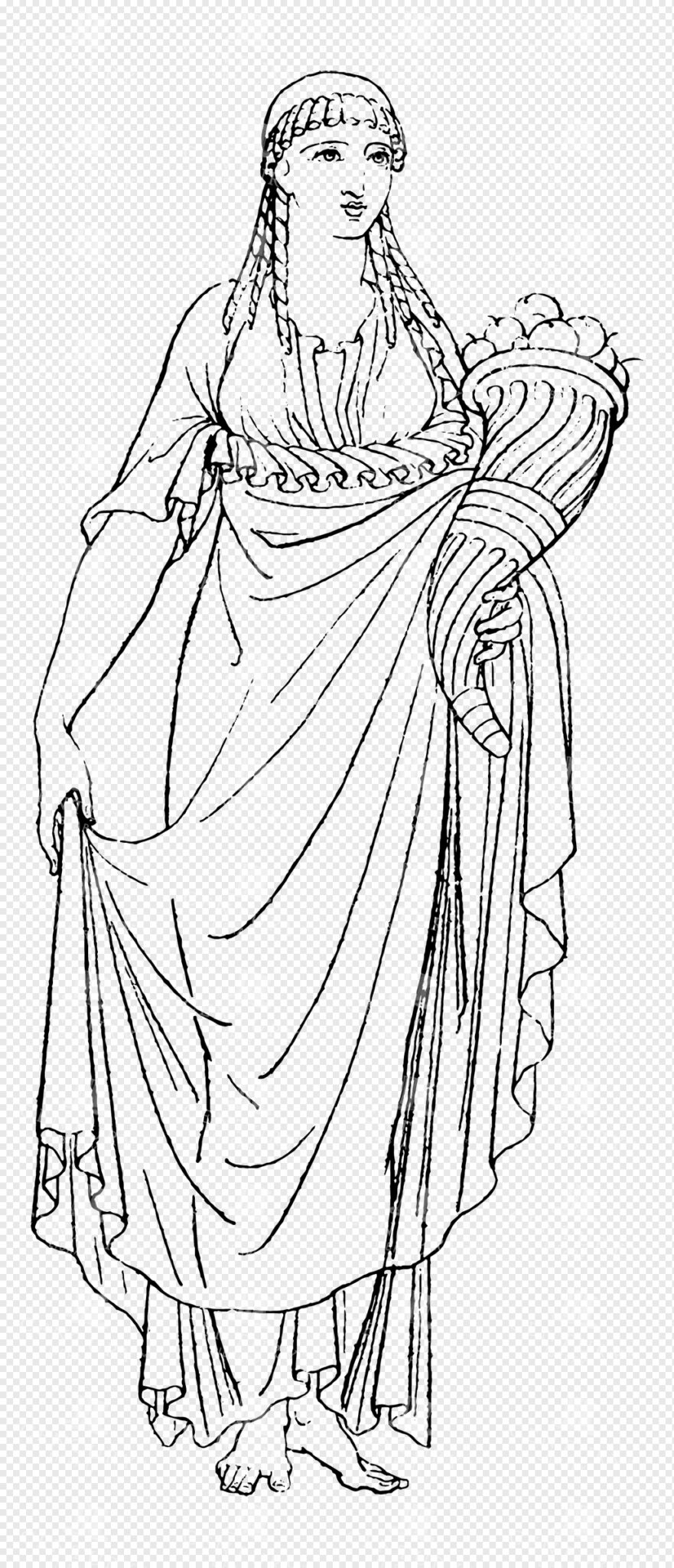
Ancient Greek or Roman Goddess Holding a Cornucopia
This image is part of our Extensive Collection of 135 Greek, Roman, and Mythology Vintage Line Art Illustrations. Each piece hand-selected from a variety of 19th-century books and ephemera found within our private library.
- Image Type(s): PNG
From this collection

Faded Decorative Calligraphy Sample from Vintage Envelope (Transparent Background)
This image is part of a curated collection that showcases a diverse range of vintage document designs and typographic art, featuring intricate letterhead logos, ornate receipts, and decorative printed overlays. Each piece captures the elegance of historical print styles—from German heraldic flourishes and British typographic traditions to antique invoices and lottery tickets. Perfect for design enthusiasts, crafters, and historians alike, these images offer a nostalgic glimpse into the artistry of printed communication, blending handwritten and printed text with ornamental details and transparent overlays.
- Resolution: 3395px x 1707px
- Image Type(s): PNG
From this collection

Vintage Map of Southern England Including London, Brighton, and Major Coastal Cities
A vintage map of Southern England, highlighting major cities like London and Brighton, as well as coastal areas. The map provides detailed insights into the region's historical geography, transportation routes, and urban development.
- Resolution: 7129 x 5100
- Image Type(s): JPG
From this collection

Antique 1800s Map of North-West Africa Highlighting Morocco, Algeria, and Western Sahara – Vintage Historical Map
This antique map from the 1800s highlights North-West Africa, including Morocco, Algeria, and the Western Sahara. It captures the colonial and geographical landscape of the time, showing intricate details of the region’s political boundaries and natural features. A beautifully preserved piece of history in vintage cartography.
- Resolution: 7102 x 5100
- Image Type(s): JPG
- 1800s
- Africa
- Africa colonial
- Africa map
- Algeria
- Antique
- antique map
- Atlas
- cartography
- colonial
- colonial era
- country
- detailed
- exploration
- Geography
- Globe
- historical
- historical map
- History
- Map
- Morocco
- natural features
- Navigation
- North-West Africa
- old
- old map
- political boundaries
- preserved
- representation
- retro
- topography
- Travel
- vintage
- vintage map
- Western Sahara
- World
From this collection

Vintage Engraving of Pangolin on Transparent Background
Detailed vintage engraving of a pangolin, presented on a transparent background. Ideal for educational content or creative projects.
- Resolution: 5461 × 2823
- Image Type(s): PNG
From this collection
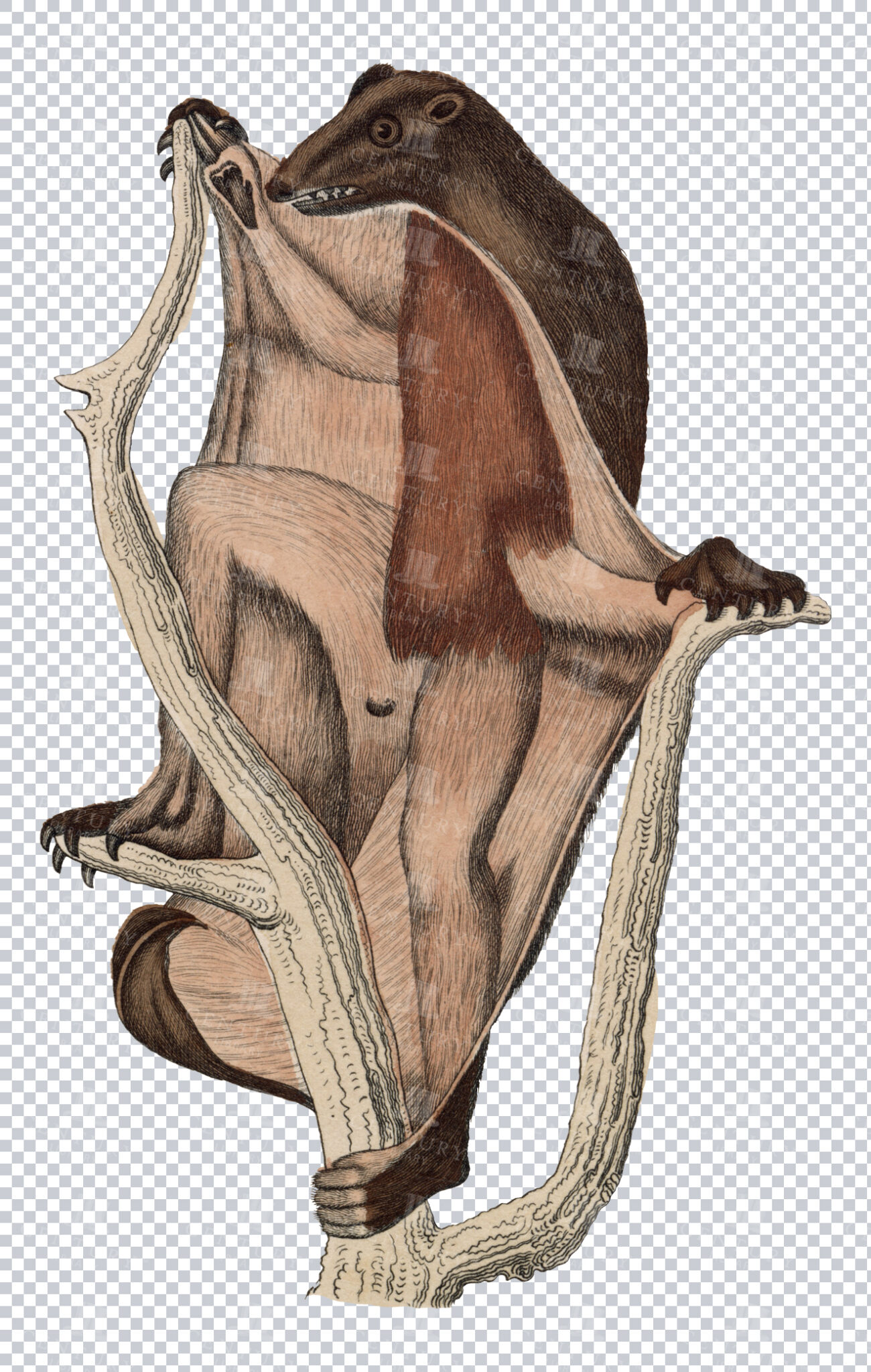
Vintage Engraving of Flying Lemur on Transparent Background
Detailed vintage illustration of a flying lemur, showing its gliding membrane on a transparent background. Ideal for educational resources, design projects, or zoological studies.
- Resolution: 2908 × 4578
- Image Type(s): PNG
- 19th-century
- Animal
- Antique
- Art
- artistic
- Background
- biology
- Black and white
- collectible
- Design
- detailed
- Drawing
- education
- Engraving
- Etching
- exotic
- fauna
- Flying
- gliding
- Harp
- historical
- History
- illustration
- isolated
- Lemur
- Mammal
- membrane
- monochrome
- natural
- Nature
- old-fashioned
- retro
- scientific
- Texture
- traditional
- transparent
- unique
- vintage
- Wildlife
- Zoology
From this collection

Vintage Engraving of Platypus on Transparent Background
Detailed vintage illustration of a platypus, showcasing intricate features and texture on a transparent background. Perfect for educational content, design, or wildlife projects.
- Resolution: 4723 × 2500
- Image Type(s): PNG
- 19th-century
- Animal
- Antique
- aquatic
- Art
- artistic
- Australia
- Background
- biology
- Black and white
- collectible
- Design
- detailed
- Drawing
- duck-billed
- education
- Engraving
- Etching
- exotic
- fauna
- historical
- History
- illustration
- isolated
- Mammal
- monochrome
- natural
- Nature
- old-fashioned
- Platypus
- retro
- scabbard
- scientific
- sheath
- Texture
- traditional
- transparent
- unique
- vintage
- Wildlife
- Zoology
From this collection

Historical Map of Cornwall, Devonshire, Dorset, and the Channel Islands
This historical map showcases the regions of Cornwall, Devonshire, Dorset, and the Channel Islands, detailing their towns, roads, and coastal features. The map is an essential resource for those interested in the historical geography of southern England. The vintage style and detailed cartography offer a unique insight into the area’s past, making it a valuable piece for collectors and history enthusiasts alike.
- Resolution: 7130 x 5100
- Image Type(s): JPG
- vintage england
- british geography
- england history
- dorset map
- devonshire map
- cornwall map
- southern england
- channel islands
- dorset
- devonshire
- english cartography
- detailed map
- english geography
- channel islands map
- vintage british map
- southern england map
- british vintage
- old england map
- coastal map
- england regions
- vintage cartography
- cornwall
- historical geography
- antique map
- historical map
- old map
- towns
- historical
- Roads
- vintage
- representation
- British History
- Geography
- Atlas
- World
- Map
From this collection

Ancient Greek or Persian Noble Holding Scepter and Scroll
This image is part of our Extensive Collection of 135 Greek, Roman, and Mythology Vintage Line Art Illustrations. Each piece hand-selected from a variety of 19th-century books and ephemera found within our private library.
- Image Type(s): PNG
From this collection
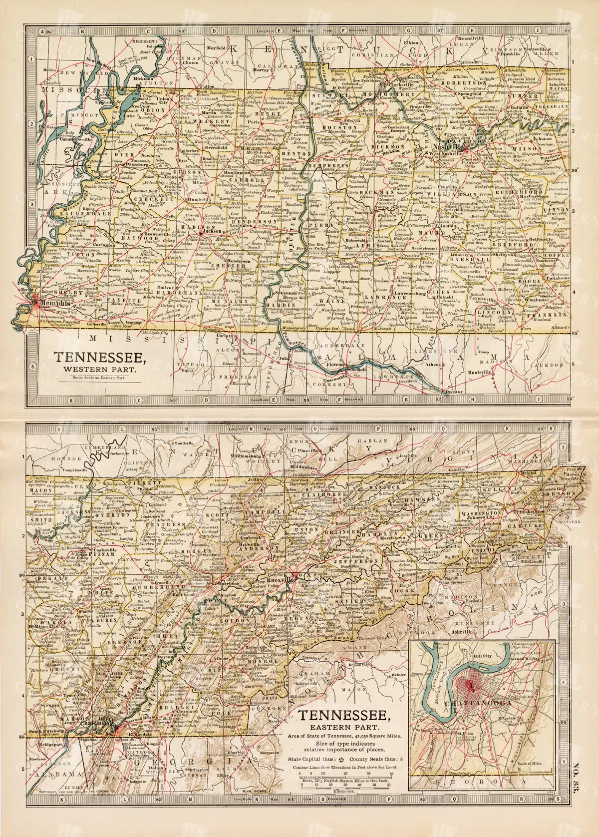
Antique Map of Tennessee, USA – Eastern and Western Parts
An antique map from the 19th century depicting both the eastern and western parts of Tennessee, USA. The map shows various towns, railways, and natural features, providing a comprehensive view of the state’s geography and development during the period.
- Resolution: 7268 x 5100
- Image Type(s): JPG
From this collection

Antique Map of Western England and Wales Including Detailed Regional Boundaries
An antique map of Western England and Wales, showcasing detailed regional boundaries and cities like Liverpool and Manchester. The map highlights important geographical features, transportation routes, and historical landmarks in the area.
- Resolution: 7126 x 5100
- Image Type(s): JPG
From this collection

Antique Map of West Virginia
Detailed antique map of West Virginia, showing counties, towns, railroads, and geographical features. Historical 19th century cartography with insets of surrounding areas. An educational and collectible piece.
- Resolution: 7280 x 5100
- Image Type(s): JPG
- 19th-century
- American history
- Antique
- archival
- Atlas
- cartographer
- cartography
- classic
- collectible
- counties
- detailed map
- education
- exploration
- geographical features
- Geography
- Globe
- heritage
- heritage map
- historical
- historical map
- historical regions
- History
- Map
- nostalgic
- old
- old map
- railroads
- reference
- representation
- state boundaries
- state map
- surrounding areas
- topography
- towns
- transportation
- USA
- vintage
- vintage west virginia
- West Virginia
- west virginia counties
- west virginia map
- World
From this collection
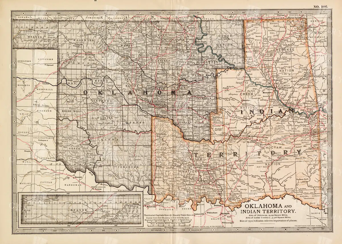
Antique Map of Oklahoma and Indian Territory from the 19th Century
This antique map from the 19th century illustrates Oklahoma and Indian Territory, showcasing the regions before statehood. It details the counties, settlements, and major transportation routes of the time.
- Resolution: 7249 x 5100
- Image Type(s): JPG
From this collection

Antique Map of Northern Ohio with Detailed City and County Lines
A historic map from the late 19th century detailing Northern Ohio, including major cities, counties, and transportation routes. This antique map highlights the region's development and infrastructure.
- Resolution: 7247 x 5100
- Image Type(s): JPG
From this collection

Jesus on the Cross Isolated PNG Illustration
An isolated PNG illustration of Jesus on the cross, rendered in vintage line art style, ideal for religious, spiritual, and artistic designs.
- Image Type(s): PNG
Related Images

Antique Map of Mexico Showing Topography and Major Cities
An antique map of Mexico displaying the topography, major cities, and transportation routes, with a focus on the geographical diversity and historical boundaries from the early 20th century.
- Resolution: 7163 x 5100
- Image Type(s): JPG
From this collection

Antique Map of Northern England Including Northumberland, Durham, and Isle of Man
An antique map of Northern England, showcasing regions like Northumberland and Durham, as well as the Isle of Man inset. The map provides detailed insights into the region's historical geography, including towns, transportation routes, and coastal features.
- Resolution: 7124 x 5100
- Image Type(s): JPG
From this collection

Detailed Vintage Map of Central America Including Guatemala and Nicaragua
A detailed vintage map of Central America, featuring countries like Guatemala and Nicaragua. The map highlights important geographical features, cities, and transportation routes, providing a historical perspective on the region.
- Resolution: 7116 x 5100
- Image Type(s): JPG
From this collection

Antique Map of Turkey in Asia with Russian Trans-Caucasia
A richly detailed antique map from the 19th century depicting Turkey in Asia, including regions like Anatolia, Armenia, Kurdistan, Mesopotamia, and Syria, along with parts of Russian Trans-Caucasia. The map highlights historical borders and settlements.
- Resolution: 7273 x 5100
- Image Type(s): JPG
From this collection
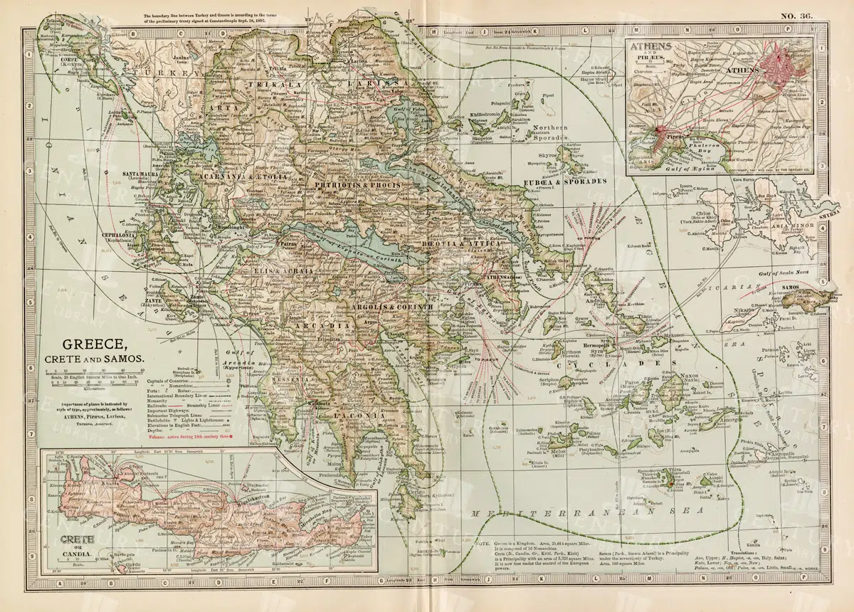
Antique Map of Greece Highlighting Crete and Samos with Detailed Topography
This antique map of Greece highlights the regions of Crete and Samos, showing detailed topographical features such as mountains, rivers, and coastlines. The map provides a historical overview of the geopolitical boundaries, major cities, and maritime routes in the Aegean Sea during the late 19th century. It offers a valuable perspective on the landscape and political divisions of Greece and its islands at the time.
- Resolution: 7140 x 5100
- Image Type(s): JPG
From this collection

Vintage Map of Northern England and Wales Highlighting Major Cities and Geographic Features
A vintage map of Northern England and Wales, detailing major cities, towns, and geographical features. The map includes important transportation routes and provides a historical overview of the region during the period.
- Resolution: 7125 x 5100
- Image Type(s): JPG
From this collection

Vintage 1800s Map of Southern Africa Including South Africa, Namibia, and Surrounding Territories – Antique Map
A vintage map from the 1800s depicting Southern Africa, including South Africa, Namibia, and surrounding territories. This antique map highlights the region’s colonial borders, cities, and natural features, offering a detailed view of the area during the colonial period. Perfect for history and cartography enthusiasts.
- Resolution: 7103 x 5100
- Image Type(s): JPG
From this collection

Greek Lady in Robes Sitting Among Botanical Vintages and Florals
An illustration of a Greek lady dressed in robes, surrounded by vintage botanical and floral motifs, perfect for classical or historical themed designs.
- Image Type(s): PNG
Related Images

Antique Map of Western Pennsylvania from the 19th Century with Pittsburgh Inset
This antique map highlights Western Pennsylvania from the 19th century, featuring cities, counties, and transportation routes. Includes an inset of Pittsburgh and its vicinity, showcasing urban growth.
- Resolution: 7252 x 5100
- Image Type(s): JPG
From this collection

Historical Map of Manitoba, British Columbia, and the Northwest Territories
A detailed historical map depicting the regions of Manitoba, British Columbia, and the Northwest Territories, showcasing topographical features, settlements, and boundaries in the early 20th century.
- Resolution: 7160 x 5100
- Image Type(s): JPG
- topographical
- northwest
- columbia
- manitoba
- settlements
- early
- 20th
- demographics
- century
- provincial
- division
- resources
- settlement
- climate
- infrastructure
- regions
- boundaries
- colonial
- territories
- exploration
- cartography
- transportation
- coastline
- historical
- natural
- vintage
- representation
- Antique
- History
- River
- Geography
- Atlas
- British
- World
- Landscape
- Canada
- Globe
- Map
- Travel
- Borders
From this collection

Antique Map of Central and Eastern England Including Nottingham and Cambridge
An antique map of Central and Eastern England, featuring detailed views of cities like Nottingham and Cambridge. The map highlights important transportation networks, geographical features, and regional boundaries, offering historical context for the area.
- Resolution: 7128 x 5100
- Image Type(s): JPG
From this collection

Ancient Roman Emperor in Profile with Ornate Headpiece, Braided Beard, and Regal Adornments
This image is part of our Extensive Collection of 135 Greek, Roman, and Mythology Vintage Line Art Illustrations. Each piece hand-selected from a variety of 19th-century books and ephemera found within our private library.
- Image Type(s): PNG
From this collection

Vintage Eight-Pointed Heraldic Star Illustration
An isolated PNG image of a vintage eight-pointed star, often used in heraldic designs. The star is colored in alternating shades of gold and blue, symbolizing guidance, protection, and the heavens. This classic design element is ideal for use in projects that require historical or celestial themes.
- Resolution: 1255 x 1928
- Image Type(s): PNG
- Ancient
- Antique
- Art
- Artwork
- blue
- celestial
- classic
- coatofarms
- Compass
- Crest
- culture
- Decorative
- Design
- eightpointed
- Emblem
- five-spot
- Gold
- Graphic
- Heraldry
- historical
- History
- iconography
- identity
- illustration
- isolated
- legacy
- Machine
- mechanical device
- medieval
- Navigation
- nobility
- noble
- pinwheel
- PNG
- Royalty
- Shield
- Star
- style
- symbol
- tradition
- traditional
- vintage
- Wheel
Related Images

Antique Map of Wisconsin
Historical antique map of Wisconsin, showing counties, towns, railroads, rivers, and other geographical features. A 19th century map that illustrates the development and infrastructure of the state.
- Resolution: 7281 x 5100
- Image Type(s): JPG
- 19th-century
- American history
- Antique
- Atlas
- cartographer
- cartography
- classic
- collectible
- counties
- detailed map
- education
- exploration
- geographical features
- Geography
- heritage
- heritage map
- historical
- historical development
- historical map
- historical regions
- History
- infrastructure
- Map
- nostalgic
- old map
- railroads
- reference
- representation
- Rivers
- state boundaries
- state map
- topography
- towns
- transportation
- USA
- vintage
- vintage wisconsin
- Wisconsin
- wisconsin counties
- wisconsin map
- World
From this collection

Detailed 19th Century Map of Ontario with Inset of Toronto and Vicinity
A richly detailed map of Ontario from the late 19th century, featuring county divisions, cities, and a prominent inset of Toronto and its surrounding areas, highlighting important transportation routes.
- Resolution: 7250 x 5100
- Image Type(s): JPG
From this collection

Vintage Map of the Southwestern Part of the German Empire with Regional Details
This vintage map of the southwestern part of the German Empire details the region’s cities, roads, and geographical features. The map provides a historical overview of the area, including key locations like Munich and Stuttgart. The vintage style and precise detailing make it an essential resource for those interested in the history and geography of this region. The map also includes insets of specific cities, offering additional insight into the urban development of the time.
- Resolution: 7139 x 5100
- Image Type(s): JPG
- historical german map
- detailed german map
- old germany map
- german vintage
- german towns
- german regions
- historical germany map
- german cities
- vintage germany
- german geography
- southwestern
- munich
- southwestern german map
- southwestern germany
- stuttgart map
- munich map
- stuttgart
- german empire map
- german cartography
- german history
- german empire
- detailed map
- vintage cartography
- antique geography
- historical geography
- antique map
- historical map
- old map
- towns
- historical
- Roads
- vintage
- old
- representation
- Antique
- Geography
- Atlas
- World
- Map
From this collection

Historical Map of the Eastern Part of the German Empire
This historical map of the eastern part of the German Empire showcases its towns, roads, and geographical features in great detail. The map offers a glimpse into the region’s past, highlighting key cities like Berlin and Hamburg. Insets provide additional details about these major cities, making the map an essential resource for historians and collectors interested in German history and cartography.
- Resolution: 7137 x 5100
- Image Type(s): JPG
- historical german map
- eastern german map
- detailed german map
- old germany map
- german vintage
- german towns
- german regions
- historical germany map
- german cities
- eastern germany
- vintage germany
- german geography
- hamburg map
- berlin map
- german empire map
- german cartography
- german history
- hamburg
- german empire
- detailed map
- vintage cartography
- antique geography
- historical geography
- antique map
- historical map
- old map
- towns
- historical
- Roads
- vintage
- representation
- Eastern
- Antique
- Berlin
- Geography
- Atlas
- World
- Map
From this collection

Vintage Map of Eastern China with Detailed Regions and Cities like Beijing and Shanghai
A vintage map of Eastern China, detailing major cities such as Beijing and Shanghai. The map provides insights into the region's geography, transportation networks, and historical context, offering a comprehensive view of Eastern China's layout.
- Resolution: 7118 x 5100
- Image Type(s): JPG
From this collection

Antique Historical Map of Western Austria-Hungary Featuring Vienna and Prague
An antique map of the western part of Austria-Hungary, highlighting major cities like Vienna and Prague. The map provides intricate details of regional boundaries, railway networks, and topographical features, reflecting the historical political landscape of the region.
- Resolution: 7111 x 5100
- Image Type(s): JPG
From this collection

Red Heraldic Lion in Vintage Style Illustration
A striking isolated PNG image of a red lion, rendered in a vintage heraldic style. The lion is depicted in a rearing posture, symbolizing strength, courage, and nobility. This traditional design element is ideal for use in projects that require a bold and historic emblem.
- Resolution: 967 x 1899
- Image Type(s): PNG
Related Images

Antique 19th Century Map of Oregon Featuring Detailed Topographical Features
A detailed antique map from the 19th century showcasing the state of Oregon, including its mountains, rivers, and settlements. This map highlights the state's topography and early infrastructure development.
- Resolution: 7251 x 5100
- Image Type(s): JPG
From this collection

Historical Map of Northern Michigan and Surrounding Great Lakes
A historical map of Northern Michigan, including surrounding areas of the Great Lakes, highlighting major towns, transportation routes, and natural features from the early 20th century.
- Resolution: 7164 x 5100
- Image Type(s): JPG
From this collection

Ancient Warrior or God Holding Bow and Spear with Crown
This image is part of our Extensive Collection of 135 Greek, Roman, and Mythology Vintage Line Art Illustrations. Each piece hand-selected from a variety of 19th-century books and ephemera found within our private library.
- Image Type(s): PNG
From this collection

Detailed 19th Century Map of Eastern Pennsylvania with Philadelphia Inset
A historic map from the 19th century depicting Eastern Pennsylvania, including detailed county lines, cities, and an inset of Philadelphia. This map captures the region's development and growth.
- Resolution: 7253 x 5100
- Image Type(s): JPG
From this collection

Detailed Map of the Northern Part of the German Empire with Key Cities
This detailed map of the northern part of the German Empire highlights key cities such as Hamburg and Berlin, along with roads and geographical features. The map offers a historical perspective on the region's landscape and its urban development during the time period. Its vintage style and detailed cartography make it an invaluable resource for collectors and history enthusiasts. The map’s detailed depiction of the area’s geography is a window into the past.
- Resolution: 7138 x 5100
- Image Type(s): JPG
- Antique
- antique geography
- antique map
- Atlas
- Berlin
- berlin map
- detailed german map
- detailed map
- Geography
- german cartography
- german cities
- german empire
- german empire map
- german geography
- german history
- german regions
- german towns
- german vintage
- hamburg
- hamburg map
- historical
- historical geography
- historical german map
- historical germany map
- historical map
- Map
- northern
- northern german map
- northern germany
- old germany map
- old map
- representation
- Roads
- towns
- vintage
- vintage cartography
- vintage germany
- World
From this collection

Vintage Map of Southern France Featuring Marseille and the Mediterranean Coast
This vintage map of Southern France details the region’s towns, roads, and geographical features, with a particular focus on Marseille and the Mediterranean coast. The map provides a comprehensive look at the area’s historical geography, making it a valuable addition for collectors and history enthusiasts. The insets offer additional details about Marseille and surrounding areas, enhancing the map's appeal and utility.
- Resolution: 7135 x 5100
- Image Type(s): JPG
- marseille geography
- mediterranean map
- mediterranean coast
- marseille map
- southern france
- marseille
- old france map
- france vintage
- france towns
- france regions
- french history
- detailed map
- vintage cartography
- french geography
- historical france map
- vintage france
- france cartography
- french map
- france history
- historical geography
- antique map
- historical map
- old map
- southern
- towns
- historical
- Roads
- country
- vintage
- representation
- Mediterranean
- Antique
- Geography
- Atlas
- World
- Globe
- France
- Map
- Travel
From this collection

Vintage Map of Northern California Including San Francisco and Yosemite Valley
A vintage map depicting the northern part of California, highlighting major cities like San Francisco and natural landmarks such as Yosemite Valley. The map provides detailed insights into the region's geographical features, transportation routes, and historical importance.
- Resolution: 7113 x 5100
- Image Type(s): JPG
From this collection

Empire of Austria-Hungary Historical Map with Detailed Regional Boundaries and Railways
This historical map of the Austria-Hungary Empire showcases detailed regional boundaries, cities, and extensive railway networks. The map includes significant areas like Budapest and Vienna, providing a comprehensive view of the empire's geographical and political landscape during the period.
- Resolution: 7112 x 5100
- Image Type(s): JPG
From this collection

Detailed Vintage Map of Southeast Australia Including Victoria, New South Wales, and South Australia
A detailed vintage map showing the southeast part of Australia, including Victoria, New South Wales, and parts of South Australia and Queensland. The map highlights major cities, railways, and geographical features, offering a historical perspective on the region's layout during the period.
- Resolution: 7110 x 5100
- Image Type(s): JPG
From this collection

Antique 1800s Map of Arabia, Oman, and Aden Including the Arabian Peninsula – Vintage Historical Map
This antique map from the 1800s illustrates the Arabian Peninsula, including Arabia, Oman, and Aden. The vintage map highlights the region's historical geography, boundaries, and important cities, offering a detailed view of the area during the colonial period. A valuable resource for those interested in Middle Eastern history and cartography.
- Resolution: 7106 x 5100
- Image Type(s): JPG
From this collection
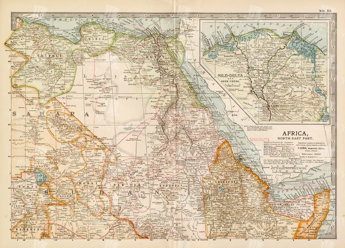
Vintage 1800s Map of North-East Africa Including Egypt, Sudan, and the Nile Delta – Antique Historical Map
This vintage map from the 1800s illustrates North-East Africa, including Egypt, Sudan, and the Nile Delta. The map is a beautiful representation of the region's historical geography, showing important cities, boundaries, and geographical features from the colonial era. A valuable piece for those interested in African history and cartography.
- Resolution: 7101 x 5100
- Image Type(s): JPG
- 1800s
- Africa
- Africa colonial
- Africa map
- Antique
- antique map
- Atlas
- boundaries
- cartography
- cities
- colonial era
- detailed
- Egypt
- exploration
- Geography
- historical
- historical geography
- historical map
- illustration
- Map
- Nile Delta
- North-East Africa
- old map
- preserved
- representation
- retro
- Rivers
- Sudan
- topography
- Travel
- vintage
- vintage map
- World
From this collection

Vintage Yellow Heraldic Flower Emblem with Detailed Petal Design from 1800s
This beautifully restored heraldic flower emblem from the 1800s showcases vibrant yellow petals arranged in a circular pattern, accented with bold outlines. An exquisite piece of vintage heraldry, perfect for historical and emblematic design projects.
- Resolution: 588 x 588
- Image Type(s): PNG
- 1800s
- artistic
- Artwork
- classic
- clipart
- Coat of Arms
- Crest
- Decoration
- Decorative
- Design
- digital asset
- Emblem
- Floral
- flower emblem
- flower illustration
- Garden
- Graphic
- heraldic flower
- Heraldry
- historical
- historical artwork
- historical illustration
- illustration
- Insignia
- medieval
- Nature
- Ornamental
- PNG
- restored
- symbol
- traditional
- vintage
- yellow flower
Related Images

Antique Map of Washington State
Antique map of Washington State, featuring towns, counties, railroads, and geographical features such as rivers and mountains. 19th century cartography highlighting the development and infrastructure of the state.
- Resolution: 7278 x 5100
- Image Type(s): JPG
- 19th-century
- American history
- Antique
- archival
- Atlas
- cartographer
- cartography
- classic
- collectible
- counties
- detailed map
- education
- exploration
- geographical features
- Geography
- heritage
- historical
- historical map
- historical washington
- History
- infrastructure
- Map
- Mountains
- northwest history
- nostalgic
- old map
- pacific northwest
- railroads
- reference
- representation
- Rivers
- state boundaries
- state development
- towns
- transportation
- USA
- vintage
- Washington
- washington geography
- washington map
- washington state
- World
From this collection

19th Century Map of Switzerland, Liechtenstein, and Parts of Austria-Hungary
A detailed antique map from the 19th century showcasing Switzerland, Liechtenstein, and parts of Austria-Hungary. The map highlights the mountainous terrain, lakes, and major cities, reflecting the historical borders and settlements of the region.
- Resolution: 7267 x 5100
- Image Type(s): JPG
From this collection

Vintage Map of Montana
An antique map showcasing the state of Montana, highlighting counties, cities, and geographical features in fine detail, typical of late 19th to early 20th century cartography.
- Resolution: 7235 x 5100
- Image Type(s): JPG
From this collection

Support the Library
Our supporters and members help us continue collecting and restoring these wonderful pieces of art for the modern creator
Unlock Everything and Become a Member!
While a lot of the library is available for free, some is kept behind closed dusty doors only to be accessed by our lovely members.