

Antique Map of the United States
Detailed antique map of the United States showing states, territories, railroads, and cities, with inset of Alaska. Includes topographical features, rivers, and mountain ranges.
- Resolution: 7275 x 5100
- Image Type(s): JPG
- state lines
- united states map
- nostalgic
- america map
- cartographer
- reference
- archival
- USA
- topographical
- mountain ranges
- railroads
- cities
- antique map
- historical map
- territories
- exploration
- old map
- cartography
- vintage map
- American history
- transportation
- states
- historic
- education
- 19th-century
- collectible
- historical
- detailed
- heritage
- illustration
- vintage
- Atlantic Ocean
- Antique
- History
- Alaska
- Pacific Ocean
- Geography
- United States
- America
- Rivers
- Map
- Borders
From this collection

Vintage Map of Southern England and Wales Highlighting Major Cities and Coastal Areas
This vintage map of Southern England and Wales highlights major cities, coastal areas, and important transportation routes. The map provides detailed insights into the region's historical geography and urban development during the period.
- Resolution: 7127 x 5100
- Image Type(s): JPG
From this collection
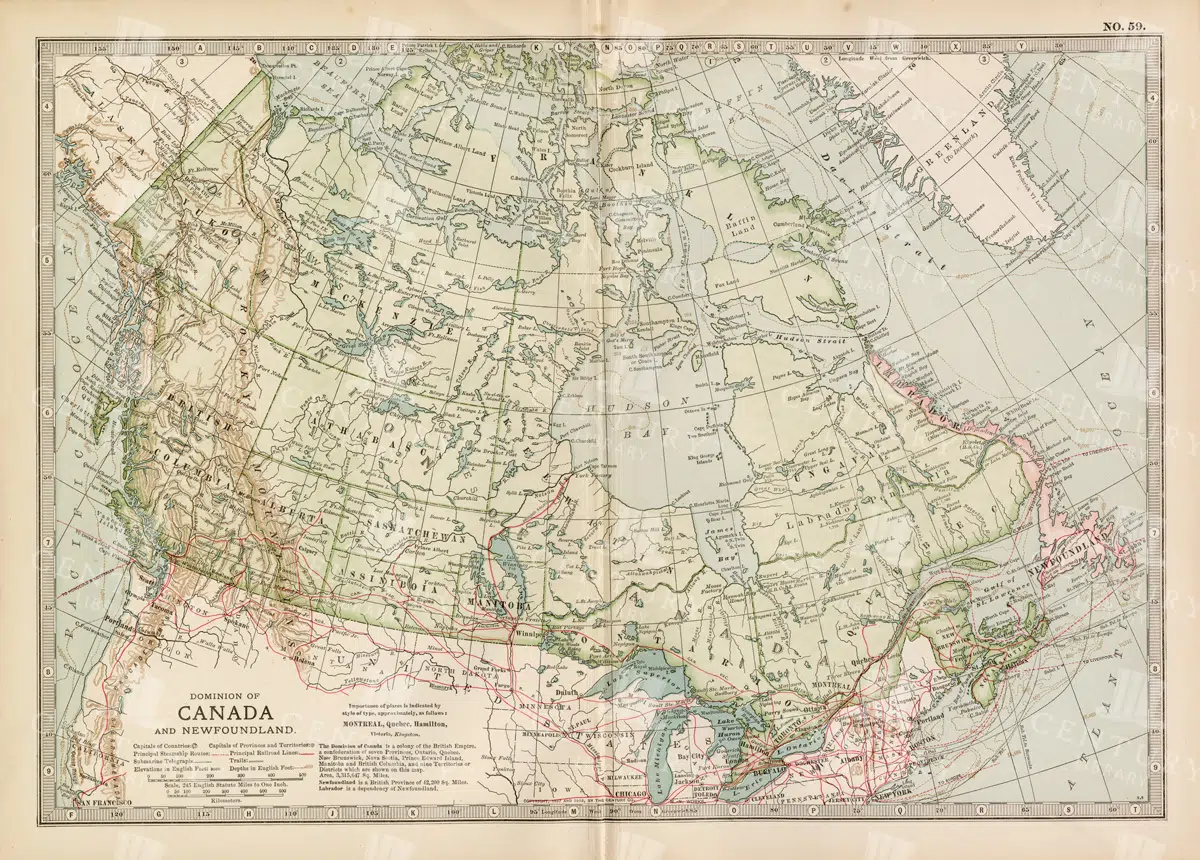
Antique Map of Canada and Newfoundland Highlighting Major Cities and Natural Features
An antique map of Canada and Newfoundland, offering a detailed look at the region's cities, natural landmarks, and geographical features. The map provides insights into the historical significance of the area during the time of its creation.
- Resolution: 7115 x 5100
- Image Type(s): JPG
From this collection

Antique Map of Vermont and New Hampshire
Detailed antique map showing the states of Vermont and New Hampshire with towns, railroads, rivers, and geographical features. Historical cartography showcasing 19th century state boundaries and infrastructures.
- Resolution: 7276 x 5100
- Image Type(s): JPG
- 19th-century
- American history
- Antique
- archival
- Atlantic Ocean
- Atlas
- Borders
- cartographer
- cartography
- classic
- collectible
- detailed map
- education
- exploration
- geographical features
- Geography
- heritage
- historic
- historical
- historical map
- History
- infrastructures
- Map
- New England
- New Hampshire
- new hampshire map
- nostalgic
- old map
- railroads
- reference
- representation
- Rivers
- state boundaries
- state lines
- states
- towns
- transportation
- USA
- Vermont
- vermont map
- vintage
- vintage map
From this collection

Vintage Map of Southern England Including London, Brighton, and Major Coastal Cities
A vintage map of Southern England, highlighting major cities like London and Brighton, as well as coastal areas. The map provides detailed insights into the region's historical geography, transportation routes, and urban development.
- Resolution: 7129 x 5100
- Image Type(s): JPG
From this collection

Detailed Vintage Map of Central America Including Guatemala and Nicaragua
A detailed vintage map of Central America, featuring countries like Guatemala and Nicaragua. The map highlights important geographical features, cities, and transportation routes, providing a historical perspective on the region.
- Resolution: 7116 x 5100
- Image Type(s): JPG
From this collection

Vintage Map of Northern England and Wales Highlighting Major Cities and Geographic Features
A vintage map of Northern England and Wales, detailing major cities, towns, and geographical features. The map includes important transportation routes and provides a historical overview of the region during the period.
- Resolution: 7125 x 5100
- Image Type(s): JPG
From this collection

Vintage Map of Northern California Including San Francisco and Yosemite Valley
A vintage map depicting the northern part of California, highlighting major cities like San Francisco and natural landmarks such as Yosemite Valley. The map provides detailed insights into the region's geographical features, transportation routes, and historical importance.
- Resolution: 7113 x 5100
- Image Type(s): JPG
From this collection

Detailed Vintage Map of Southeast Australia Including Victoria, New South Wales, and South Australia
A detailed vintage map showing the southeast part of Australia, including Victoria, New South Wales, and parts of South Australia and Queensland. The map highlights major cities, railways, and geographical features, offering a historical perspective on the region's layout during the period.
- Resolution: 7110 x 5100
- Image Type(s): JPG
From this collection
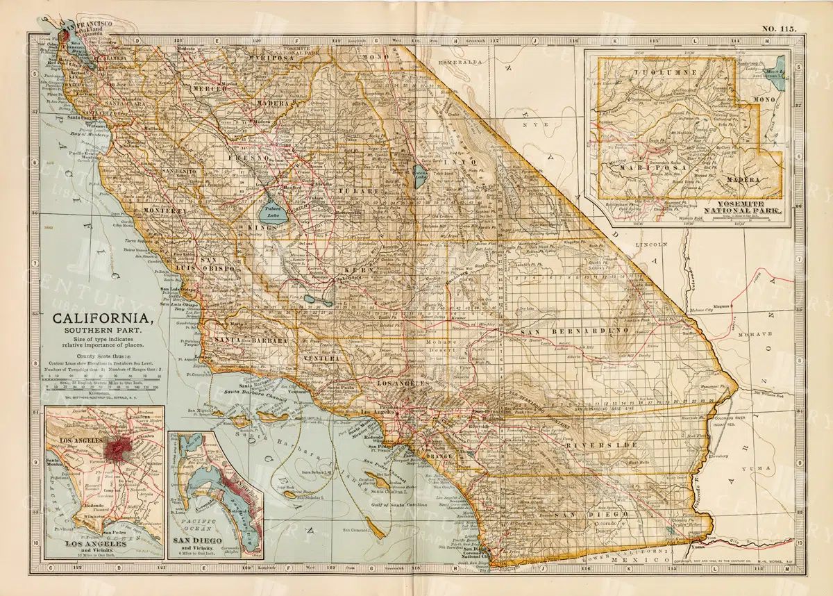
Vintage Map of Southern California Featuring Los Angeles and San Diego
This vintage map showcases the southern part of California, including major cities like Los Angeles and San Diego. The map highlights important transportation routes, natural landmarks, and the region's historical and geographical features.
- Resolution: 7114 x 5100
- Image Type(s): JPG
From this collection

Vintage Map of Connecticut and Rhode Island Including Major Cities and Coastal Features
A vintage map depicting Connecticut and Rhode Island, highlighting major cities, towns, and coastal features. The map provides detailed insights into the region's transportation routes, geographical features, and historical importance during the period.
- Resolution: 7121 x 5100
- Image Type(s): JPG
From this collection

Support the Library
Our supporters and members help us continue collecting and restoring these wonderful pieces of art for the modern creator
Unlock Everything and Become a Member!
While a lot of the library is available for free, some is kept behind closed dusty doors only to be accessed by our lovely members.