

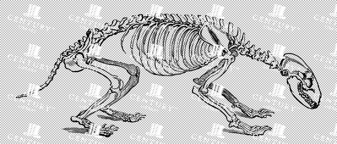
Vintage Illustration of Lariosaur Skeleton with Detailed Bone Structure as Transparent PNG
A vintage illustration of a Lariosaur skeleton, showcasing its detailed bone structure. This transparent PNG is perfect for paleontology and educational-themed projects, emphasizing the ancient reptile's anatomy.
- Resolution: 3906px x 1528px
- Image Type(s): PNG
From this collection

Detailed Decorative Certificate Border in Green with Text Space and Ornate Seals
A detailed decorative border in green, designed for certificates with text space and multiple ornate seals, perfect for diplomas or awards.
- Image Type(s): PNG
From this collection

Historical Map of Cornwall, Devonshire, Dorset, and the Channel Islands
This historical map showcases the regions of Cornwall, Devonshire, Dorset, and the Channel Islands, detailing their towns, roads, and coastal features. The map is an essential resource for those interested in the historical geography of southern England. The vintage style and detailed cartography offer a unique insight into the area’s past, making it a valuable piece for collectors and history enthusiasts alike.
- Resolution: 7130 x 5100
- Image Type(s): JPG
- vintage england
- british geography
- england history
- dorset map
- devonshire map
- cornwall map
- southern england
- channel islands
- dorset
- devonshire
- english cartography
- detailed map
- english geography
- channel islands map
- vintage british map
- southern england map
- british vintage
- old england map
- coastal map
- england regions
- vintage cartography
- cornwall
- historical geography
- antique map
- historical map
- old map
- towns
- historical
- Roads
- vintage
- representation
- British History
- Geography
- Atlas
- World
- Map
From this collection

Vintage Map of Southern England Including London, Brighton, and Major Coastal Cities
A vintage map of Southern England, highlighting major cities like London and Brighton, as well as coastal areas. The map provides detailed insights into the region's historical geography, transportation routes, and urban development.
- Resolution: 7129 x 5100
- Image Type(s): JPG
From this collection
Elegant Baroque Frame Line Art with Ornate Flourishes
A Baroque-style line art frame featuring elegant flourishes and ornate detailing, perfect for enhancing formal invitations, certificates, and decorative projects.
- Resolution: 3609px x 5379px
- Image Type(s): PNG
From this collection

Aged with Beautiful Petina – Antique Handwritten Book Scan No.13
- License Info
- Resolution: 9649px x 7934px
From this collection

Aged with Beautiful Petina – Antique Handwritten Book Scan No.2
- License Info
- Resolution: 4545px x 3838px
From this collection

Vintage Gold and Blue Frame / Border with Decorative Design Elements
- License Info
- Resolution: 2843px x 4826px
From this collection

Cream Moth With Crimson-Banded Wing Detail
- License Info
- Image Type(s): PNG
From this collection

Toile De Jouy Seamless Pattern – Black and White Vintage Countryside Design
This image is part of our Seamless Toile De Jouy Patterns collection; A collection that brings together a charming series of seamless Toile de Jouy patterns, each one lovingly restored and designed for repeat use. Featuring scenic countryside landscapes, pastoral figures, elegant florals, and classic French-inspired detailing, these patterns are ideal for anyone looking to add a vintage touch to their work. You’ll find multiple color variants—including warm sepia tones, timeless black and white, and classic French blue - all available as flat JPGs and transparent PNGs for easy layering and customisation. Perfect for scrapbooking, product packaging, surface design, fabric printing, stationery, or digital backdrops - these seamless vintage patterns are ready to tile and flow effortlessly across your designs.
- Image Type(s): PNG
From this collection

Handwritten Note with Transparent Background
This image is part of a curated collection that showcases a diverse range of vintage document designs and typographic art, featuring intricate letterhead logos, ornate receipts, and decorative printed overlays. Each piece captures the elegance of historical print styles—from German heraldic flourishes and British typographic traditions to antique invoices and lottery tickets. Perfect for design enthusiasts, crafters, and historians alike, these images offer a nostalgic glimpse into the artistry of printed communication, blending handwritten and printed text with ornamental details and transparent overlays.
- Resolution: 2794px x 3539px
- Image Type(s): PNG
From this collection
Vintage Illustration of a Badger Skeleton with Robust Bone Structure as Transparent PNG
A vintage illustration of a badger skeleton, displaying its robust bone structure. This transparent PNG is perfect for nature and educational-themed projects, focusing on the anatomy of small mammals.
- Resolution: 3140px x 1350px
- Image Type(s): PNG
From this collection

Antique Illustration of a Bee with Detailed Wing and Body Structure from the 1800s
This 1800s vintage illustration depicts a bee with highly detailed wings and body, exemplifying the insect's anatomy in historical natural history art.
- Resolution: 1079px x 1251px
- Image Type(s): PNG
Related Images

Green Intricate Square Frame with Ornate Border Patterns for Decorative Use
A detailed square frame with an intricate green border design, featuring complex patterns and ornamental details, ideal for certificates or decorative projects.
- Image Type(s): PNG
From this collection
Brown Certificate Border with Blank Center
A brown certificate border featuring wavy patterns and a blank center, suitable for awards, diplomas, and official documents.
- Image Type(s): PNG
- Antique
- arabesque
- Art
- artistic
- Award
- blank
- Border
- Brown
- center
- certificate
- classic
- decor
- Decoration
- Decorative
- delicate
- Design
- diploma
- document
- elegant
- embellished
- Engraving
- fine
- formal
- Frame
- Graphic
- heritage
- illustration
- illustrative
- lined
- official
- officialborder
- old
- old-fashioned
- Ornate
- Outline
- Pattern
- Patterned
- Photograph
- representation
- retro
- stylish
- symmetrical
- traditional
- vintage
- wavy
From this collection

Elegant Ornate Border / Letterhead Design with Subtle Beige Background for Vintage Themes
This elegant ornate border design features intricate linework on a subtle beige background. The delicate details include floral and scroll motifs, perfect for vintage-inspired projects such as invitations, certificates, or artistic presentations. The layout is sophisticated and versatile, making it ideal for classic and decorative themes.
- License Info
- Image Type(s): JPG
From this collection

Antique Map of West Virginia
Detailed antique map of West Virginia, showing counties, towns, railroads, and geographical features. Historical 19th century cartography with insets of surrounding areas. An educational and collectible piece.
- Resolution: 7280 x 5100
- Image Type(s): JPG
- nostalgic
- cartographer
- state boundaries
- historical regions
- west virginia map
- west virginia counties
- surrounding areas
- heritage map
- vintage west virginia
- state map
- reference
- archival
- geographical features
- USA
- railroads
- detailed map
- topography
- historical map
- exploration
- old map
- cartography
- American history
- transportation
- counties
- towns
- education
- 19th-century
- collectible
- historical
- heritage
- classic
- vintage
- old
- representation
- Antique
- History
- West Virginia
- Geography
- Atlas
- World
- Globe
- Map
From this collection

Antique Map of Northern Ohio with Detailed City and County Lines
A historic map from the late 19th century detailing Northern Ohio, including major cities, counties, and transportation routes. This antique map highlights the region's development and infrastructure.
- Resolution: 7247 x 5100
- Image Type(s): JPG
From this collection

Antique Map of Western England and Wales Including Detailed Regional Boundaries
An antique map of Western England and Wales, showcasing detailed regional boundaries and cities like Liverpool and Manchester. The map highlights important geographical features, transportation routes, and historical landmarks in the area.
- Resolution: 7126 x 5100
- Image Type(s): JPG
From this collection

Detailed Vintage Map of Central America Including Guatemala and Nicaragua
A detailed vintage map of Central America, featuring countries like Guatemala and Nicaragua. The map highlights important geographical features, cities, and transportation routes, providing a historical perspective on the region.
- Resolution: 7116 x 5100
- Image Type(s): JPG
From this collection

Aged with Beautiful Petina – Antique Handwritten Book Scan No.3
- License Info
- Resolution: 9257px x 7861px
From this collection

High Quality Scan of Front of Anitque Music Sheet Booklet with Worn Label
- License Info
- Resolution: 6900px x 10000px
From this collection

Decorative and Detailed Antique Frame / Border – Perfect for Invitations and Packaging No.4
- License Info
- Resolution: 3982px x 5362px
From this collection
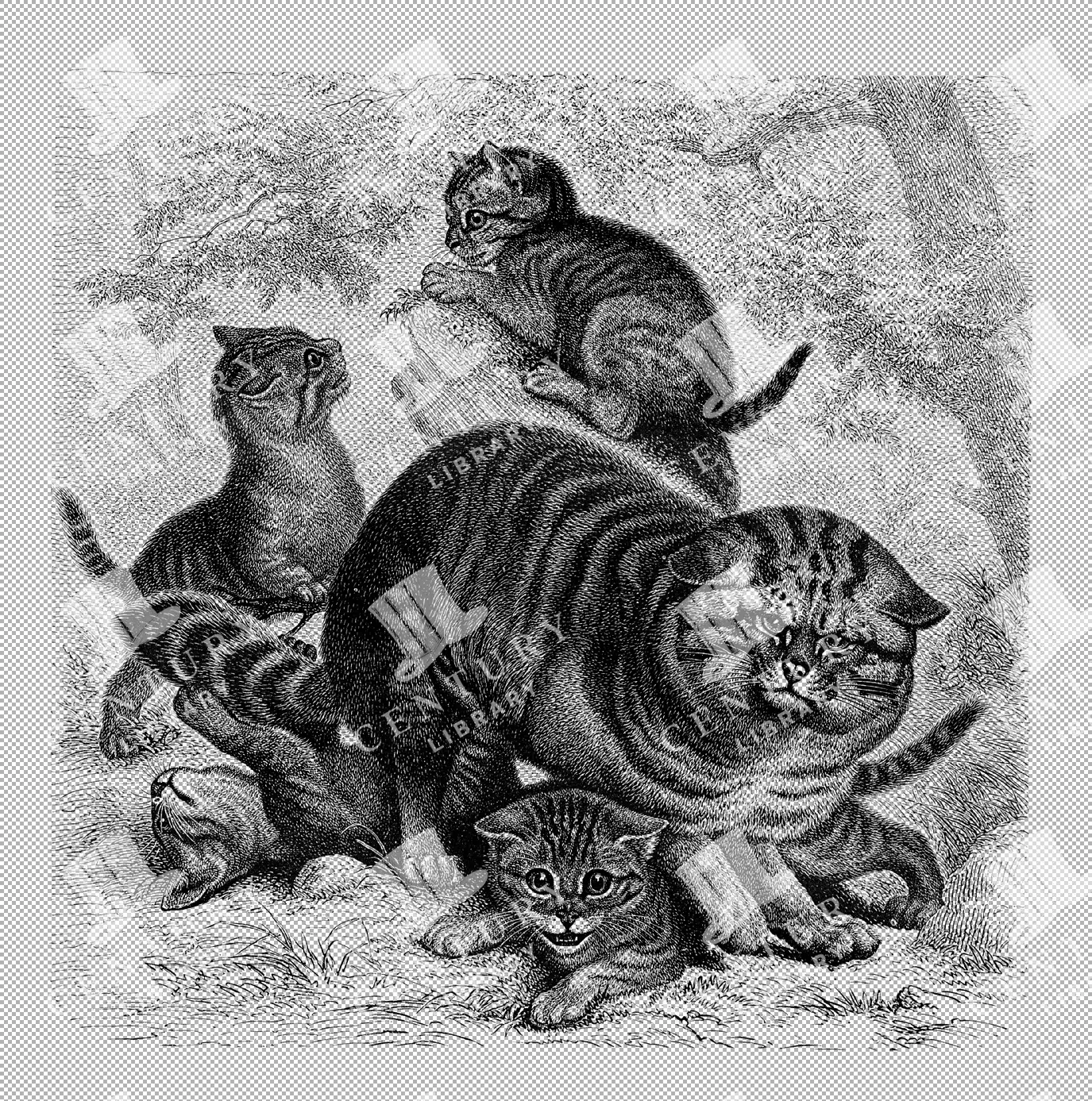
Wildcat Family with Kittens and Mother Line Art Illustration
Line art illustration of a family of wildcats, including kittens and a mother, showcasing their playful interaction and natural setting
- Resolution: 4760px x 4801px
- Image Type(s): PNG
Related Images

Virginian Uhu Perched on Branch Line Art Illustration
Illustration of a Virginian Uhu perched on a branch in line art, showcasing its distinctive ear tufts and powerful build in a natural setting
- Resolution: 3668px x 4553px
- Image Type(s): PNG
Related Images

Antique 1800s Illustration of a Bat in Flight with Detailed Wing Structure
This vintage illustration from the 1800s showcases a bat in mid-flight, highlighting its detailed wing structure and nocturnal features, typical of historical art.
- Resolution: 4609px x 2799px
- Image Type(s): PNG
Related Images

Antique Map of Turkey in Asia with Russian Trans-Caucasia
A richly detailed antique map from the 19th century depicting Turkey in Asia, including regions like Anatolia, Armenia, Kurdistan, Mesopotamia, and Syria, along with parts of Russian Trans-Caucasia. The map highlights historical borders and settlements.
- Resolution: 7273 x 5100
- Image Type(s): JPG
From this collection
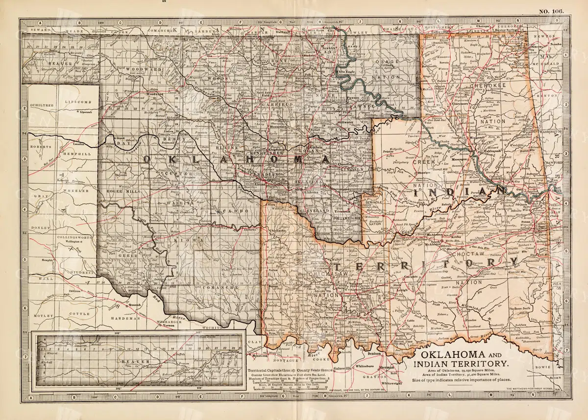
Antique Map of Oklahoma and Indian Territory from the 19th Century
This antique map from the 19th century illustrates Oklahoma and Indian Territory, showcasing the regions before statehood. It details the counties, settlements, and major transportation routes of the time.
- Resolution: 7249 x 5100
- Image Type(s): JPG
From this collection

Historic Map of New Jersey
A detailed antique map of New Jersey, highlighting its counties, cities, and significant landmarks, reflecting the state's geography and development during the late 19th century.
- Resolution: 7239 x 5100
- Image Type(s): JPG
From this collection

Vintage Map of Minnesota Featuring Lakes and Urban Areas
A vintage map of Minnesota highlighting its numerous lakes, urban areas, and transportation routes, showcasing the state's geographical diversity from the early 20th century.
- Resolution: 7166 x 5100
- Image Type(s): JPG
From this collection

Antique Map of Northern England Including Northumberland, Durham, and Isle of Man
An antique map of Northern England, showcasing regions like Northumberland and Durham, as well as the Isle of Man inset. The map provides detailed insights into the region's historical geography, including towns, transportation routes, and coastal features.
- Resolution: 7124 x 5100
- Image Type(s): JPG
From this collection

Vintage 1800s Map of Southern Africa Including South Africa, Namibia, and Surrounding Territories – Antique Map
A vintage map from the 1800s depicting Southern Africa, including South Africa, Namibia, and surrounding territories. This antique map highlights the region’s colonial borders, cities, and natural features, offering a detailed view of the area during the colonial period. Perfect for history and cartography enthusiasts.
- Resolution: 7103 x 5100
- Image Type(s): JPG
From this collection

Inside Rear Book Cover Scan – Tan Card Stock Texture
- License Info
- Resolution: 3500px x 4951px
From this collection

Blank Antique Folded and Worn Receipt Book Open Page
- License Info
- Resolution: 9746px x 7987px
From this collection

Decorative and Detailed Antique Frame / Border – Perfect for Invitations and Packaging No.18
- License Info
- Resolution: 7223px x 9189px
From this collection

Decorative and Detailed Antique Frame / Border – Perfect for Invitations and Packaging No.17
- License Info
- Resolution: 6623px x 8997px
From this collection

Decorative and Detailed Antique Frame / Border – Perfect for Invitations and Packaging No.16
- License Info
- Resolution: 6623px x 9065px
From this collection

Decorative and Detailed Antique Frame / Border – Perfect for Invitations and Packaging No.7
- License Info
- Resolution: 4553px x 6781px
From this collection


Golden Moth Watercolor: Asymmetrical Wings With Delicate Amber Hues
- Image Type(s): PNG
From this collection

West Indian Tree Frog Isolated PNG Line Art Illustration
Isolated PNG line art illustration of a West Indian tree frog, capturing its small size and unique features in a realistic and detailed style
- Resolution: 1908px x 1214px
- Image Type(s): PNG
Related Images

Vintage Illustration of Polecat Skeleton with Slender Build as Transparent PNG
A vintage illustration of a polecat skeleton, characterized by its slender build and intricate bone structure. This transparent PNG is ideal for zoological and anatomical projects.
- Resolution: 3714px x 1203px
- Image Type(s): PNG
From this collection

Green Certificate Frame with Leafy Corners and Decorative Elements
This green certificate frame features leafy corners and decorative elements, offering a refined and professional look for certificates, awards, and special documents.
- Image Type(s): PNG
- Antique
- Art
- Award
- Border
- card
- certificate
- classic
- container
- corners
- Decorative
- document
- editable
- elegant
- elements
- Embellishment
- Engraving
- Envelope
- Floral
- Frame
- Graphic
- Green
- grunge
- guilloche
- illustration
- Layout
- leafy
- old-fashioned
- Ornament
- Ornate
- Paper
- Pattern
- PNG
- printable
- professional
- refined
- retro
- scrollwork
- Stationery
- stylish
- Template
- transparent
- vintage
From this collection
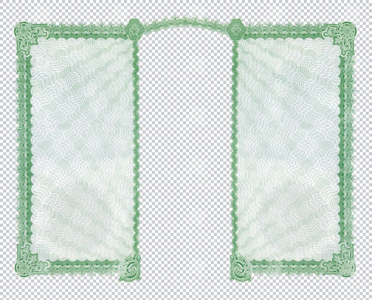
Transparent Green Dual Panel Certificate Border
An intricate green dual-panel certificate border with transparent backgrounds, designed for diplomas, awards, and high-end certificates. Elegant and sophisticated.
- Image Type(s): PNG
From this collection
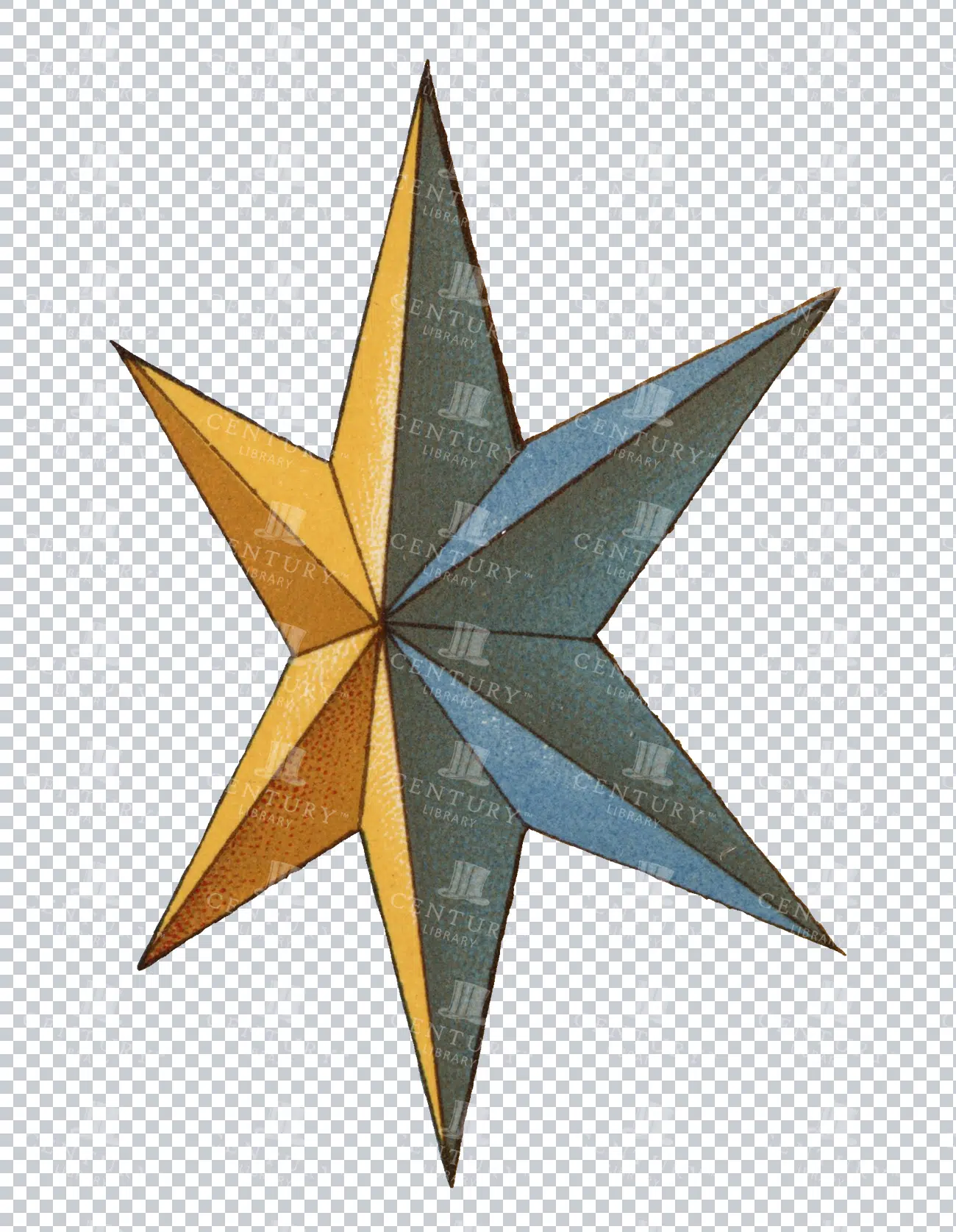
Vintage Eight-Pointed Heraldic Star Illustration
An isolated PNG image of a vintage eight-pointed star, often used in heraldic designs. The star is colored in alternating shades of gold and blue, symbolizing guidance, protection, and the heavens. This classic design element is ideal for use in projects that require historical or celestial themes.
- Resolution: 1255 x 1928
- Image Type(s): PNG
- Ancient
- Antique
- Art
- Artwork
- blue
- celestial
- classic
- coatofarms
- Compass
- Crest
- culture
- Decorative
- Design
- eightpointed
- Emblem
- five-spot
- Gold
- Graphic
- Heraldry
- historical
- History
- iconography
- identity
- illustration
- isolated
- legacy
- Machine
- mechanical device
- medieval
- Navigation
- nobility
- noble
- pinwheel
- PNG
- Royalty
- Shield
- Star
- style
- symbol
- tradition
- traditional
- vintage
- Wheel
Related Images
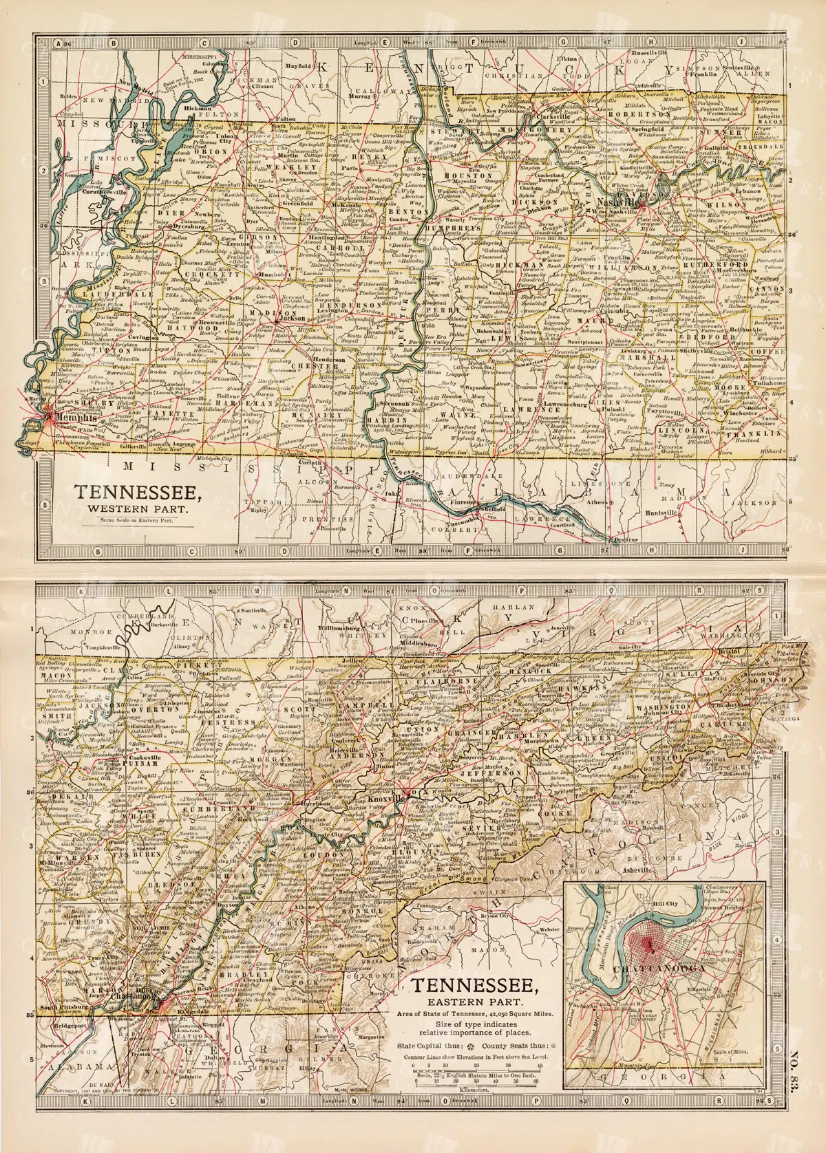
Antique Map of Tennessee, USA – Eastern and Western Parts
An antique map from the 19th century depicting both the eastern and western parts of Tennessee, USA. The map shows various towns, railways, and natural features, providing a comprehensive view of the state’s geography and development during the period.
- Resolution: 7268 x 5100
- Image Type(s): JPG
From this collection
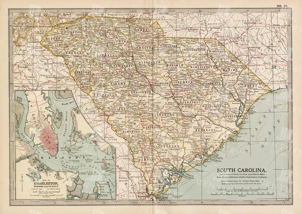
19th Century South Carolina Map with Charleston Harbor Inset
A detailed 19th century map of South Carolina, featuring an inset of Charleston Harbor. This vintage map provides a glimpse into the state's political and geographical landscape during the era, highlighting cities, transportation routes, and natural features.
- Resolution: 7263 x 5100
- Image Type(s): JPG
- 1800s
- 19th-century
- American history
- antique cartography
- antique map
- antique paper
- archival
- Atlas
- cartographic history
- cartography
- Charleston Harbor
- Charleston history
- cities
- country
- geographical features
- Geography
- heritage
- historical artifact
- historical document
- historical geography
- historical information
- historical map
- historical records
- history lovers
- Map
- map of South Carolina
- old map
- old South Carolina
- political divisions
- representation
- South Carolina
- topography
- United States
- vintage
- vintage map
- World
From this collection
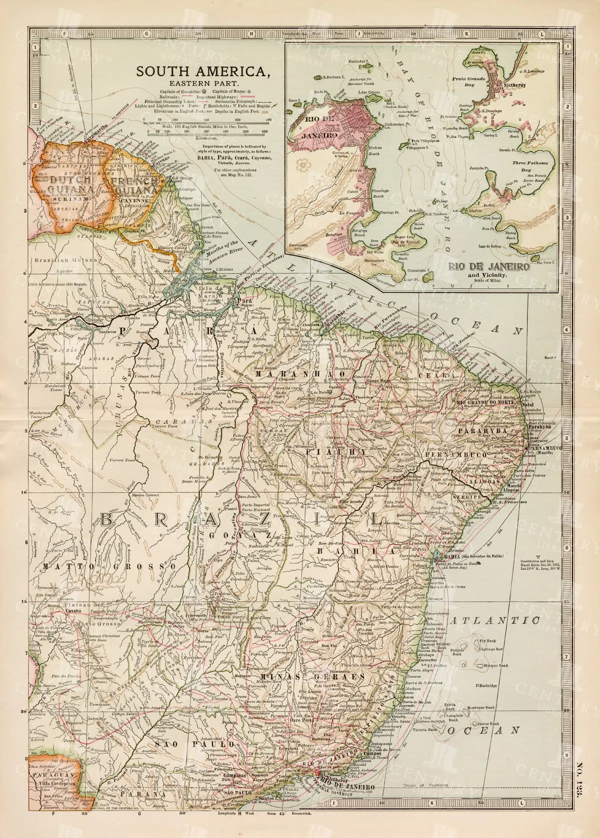
19th Century Map of Eastern South America Including Rio de Janeiro
A detailed 19th century map of Eastern South America, focusing on countries like Brazil, French Guiana, and others, with a special inset of Rio de Janeiro. This vintage map illustrates the political and geographical landscape of the time, with precise details of cities and natural features.
- Resolution: 7259 x 5100
- Image Type(s): JPG
- 1800s
- 19th-century
- antique cartography
- antique map
- antique paper
- archival
- Atlas
- Brazil
- cartographic history
- cartography
- cities
- Eastern South America
- French Guiana
- geographical features
- Geography
- heritage
- historical artifact
- historical document
- historical geography
- historical information
- historical map
- historical records
- history lovers
- Latin America
- Map
- map of Brazil
- old map
- old South America
- political divisions
- representation
- Rio de Janeiro
- South America
- South American history
- topography
- vintage
- vintage map
- World
From this collection
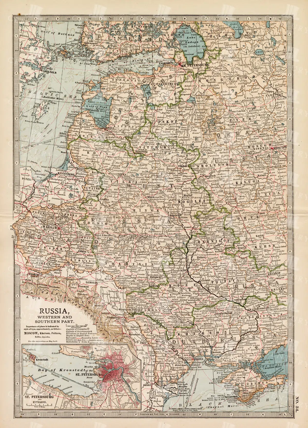
19th Century Map of Russia’s Western and Southern Parts with St. Petersburg
A detailed 19th century map highlighting the western and southern parts of Russia, including the prominent city of St. Petersburg. This vintage map showcases the political and geographical landscape of the era, featuring intricate details of cities, rivers, and borders.
- Resolution: 7257 x 5100
- Image Type(s): JPG
- 1800s
- 19th-century
- Antique
- antique cartography
- antique map
- antique paper
- archival
- Atlas
- Baltic Sea
- cartographic history
- cartography
- cities
- Eastern Europe
- european history
- geographical features
- Geography
- heritage
- historical artifact
- historical document
- historical geography
- historical information
- historical map
- historical records
- history lovers
- Map
- map of Russia
- old
- old Europe
- old map
- political divisions
- representation
- Rivers
- Russia
- Russian Empire
- southern Russia
- St. Petersburg
- St. Petersburg history
- topography
- vintage
- vintage map
- western Russia
From this collection

Vintage Map of Nevada and Utah
An antique map detailing the states of Nevada and Utah, showcasing the topography, settlements, and infrastructure from the late 19th to early 20th century, with insets of major cities.
- Resolution: 7237 x 5100
- Image Type(s): JPG
From this collection

Support the Library
Our supporters and members help us continue collecting and restoring these wonderful pieces of art for the modern creator
Unlock Everything and Become a Member!
While a lot of the library is available for free, some is kept behind closed dusty doors only to be accessed by our lovely members.