

Vintage Map of the Southwestern Part of the German Empire with Regional Details
This vintage map of the southwestern part of the German Empire details the region’s cities, roads, and geographical features. The map provides a historical overview of the area, including key locations like Munich and Stuttgart. The vintage style and precise detailing make it an essential resource for those interested in the history and geography of this region. The map also includes insets of specific cities, offering additional insight into the urban development of the time.
- Resolution: 7139 x 5100
- Image Type(s): JPG
- historical german map
- detailed german map
- old germany map
- german vintage
- german towns
- german regions
- historical germany map
- german cities
- vintage germany
- german geography
- southwestern
- munich
- southwestern german map
- southwestern germany
- stuttgart map
- munich map
- stuttgart
- german empire map
- german cartography
- german history
- german empire
- detailed map
- vintage cartography
- antique geography
- historical geography
- antique map
- historical map
- old map
- towns
- historical
- Roads
- vintage
- old
- representation
- Antique
- Geography
- Atlas
- World
- Map
From this collection

Historical Map of the Eastern Part of the German Empire
This historical map of the eastern part of the German Empire showcases its towns, roads, and geographical features in great detail. The map offers a glimpse into the region’s past, highlighting key cities like Berlin and Hamburg. Insets provide additional details about these major cities, making the map an essential resource for historians and collectors interested in German history and cartography.
- Resolution: 7137 x 5100
- Image Type(s): JPG
- historical german map
- eastern german map
- detailed german map
- old germany map
- german vintage
- german towns
- german regions
- historical germany map
- german cities
- eastern germany
- vintage germany
- german geography
- hamburg map
- berlin map
- german empire map
- german cartography
- german history
- hamburg
- german empire
- detailed map
- vintage cartography
- antique geography
- historical geography
- antique map
- historical map
- old map
- towns
- historical
- Roads
- vintage
- representation
- Eastern
- Antique
- Berlin
- Geography
- Atlas
- World
- Map
From this collection

Vintage Map of Eastern China with Detailed Regions and Cities like Beijing and Shanghai
A vintage map of Eastern China, detailing major cities such as Beijing and Shanghai. The map provides insights into the region's geography, transportation networks, and historical context, offering a comprehensive view of Eastern China's layout.
- Resolution: 7118 x 5100
- Image Type(s): JPG
From this collection

Antique Historical Map of Western Austria-Hungary Featuring Vienna and Prague
An antique map of the western part of Austria-Hungary, highlighting major cities like Vienna and Prague. The map provides intricate details of regional boundaries, railway networks, and topographical features, reflecting the historical political landscape of the region.
- Resolution: 7111 x 5100
- Image Type(s): JPG
From this collection

Antique 1800s Illustration of a Bat in Flight with Detailed Wing Structure
This vintage illustration from the 1800s showcases a bat in mid-flight, highlighting its detailed wing structure and nocturnal features, typical of historical art.
- Resolution: 4609px x 2799px
- Image Type(s): PNG
Related Images

Red Heraldic Lion in Vintage Style Illustration
A striking isolated PNG image of a red lion, rendered in a vintage heraldic style. The lion is depicted in a rearing posture, symbolizing strength, courage, and nobility. This traditional design element is ideal for use in projects that require a bold and historic emblem.
- Resolution: 967 x 1899
- Image Type(s): PNG
Related Images

19th Century Russia in Europe with Poland and Finland Vintage Map
A detailed 19th century map depicting Russia in Europe, including Poland and Finland. This historical artifact provides insight into the territorial boundaries and political divisions of the time, with intricate detailing of cities, rivers, and topographical features.
- Resolution: 7256 x 5100
- Image Type(s): JPG
- 1800s
- 19th-century
- Antique
- antique cartography
- antique map
- antique paper
- archival
- Atlas
- Baltic Sea
- Black Sea
- cartographic history
- cartography
- cities
- Eastern Europe
- european history
- Finland
- Finland history
- Geography
- heritage
- historical artifact
- historical document
- historical geography
- historical information
- historical map
- historical records
- history lovers
- Map
- map of Russia
- old Europe
- old map
- Poland
- Poland history
- political divisions
- representation
- Rivers
- Russia in Europe
- Russian Empire
- territorial boundaries
- topography
- vintage
- vintage map
- World
From this collection

Antique 19th Century Map of Oregon Featuring Detailed Topographical Features
A detailed antique map from the 19th century showcasing the state of Oregon, including its mountains, rivers, and settlements. This map highlights the state's topography and early infrastructure development.
- Resolution: 7251 x 5100
- Image Type(s): JPG
From this collection

Antique Map of Western New York
A detailed historic map showcasing the western part of New York, highlighting counties, cities, and geographical features, including insets of major urban areas like Buffalo and Rochester.
- Resolution: 7241 x 5100
- Image Type(s): JPG
From this collection

Antique Map of Maryland and Delaware with Washington D.C.
An antique map highlighting Maryland and Delaware, including insets of Washington D.C. and Baltimore, featuring roads, rivers, and county lines from the late 19th to early 20th century.
- Resolution: 7161 x 5100
- Image Type(s): JPG
- 19th
- 20th
- administrative
- American
- Antique
- Atlas
- Baltimore
- boundaries
- Capital
- cartography
- century
- City
- colonial
- county
- dc
- Delaware
- development
- early
- Geography
- heritage
- historic
- History
- infrastructure
- landmarks
- late
- Lines
- Map
- Maryland
- political
- regional
- representation
- Rivers
- Roads
- transportation
- urban
- urbanization
- vintage
- Washington
- World
From this collection

Detailed 19th Century Map of Eastern Pennsylvania with Philadelphia Inset
A historic map from the 19th century depicting Eastern Pennsylvania, including detailed county lines, cities, and an inset of Philadelphia. This map captures the region's development and growth.
- Resolution: 7253 x 5100
- Image Type(s): JPG
From this collection
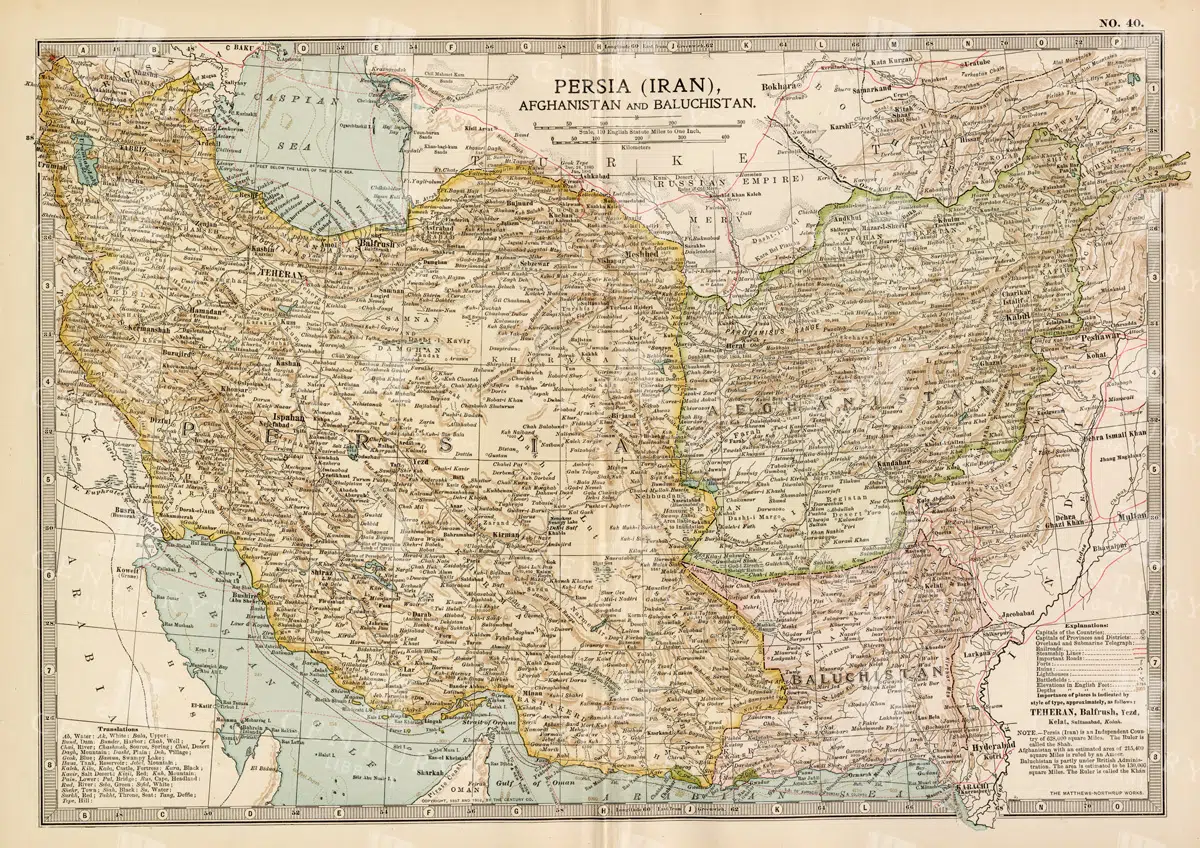
Antique Map of Persia, Afghanistan, and Baluchistan with Geopolitical Borders
This antique map of Persia (modern-day Iran), Afghanistan, and Baluchistan highlights the geopolitical borders and key cities of the early 20th century. The map details the region's topographical features, including mountain ranges, rivers, and deserts, offering a comprehensive view of the landscape. It provides a historical perspective on the political and geographical divisions in this part of the Middle East and South Asia during the period.
- Resolution: 7148 x 5100
- Image Type(s): JPG
- early 20th century
- Afghanistan history
- Persia history
- deserts
- Baluchistan
- mountain ranges
- Afghanistan
- Iran
- South Asia
- geopolitical borders
- topography
- cities
- historical geography
- antique map
- historical map
- colonial
- exploration
- old map
- cartography
- Middle East
- country
- representation
- Antique
- Persia
- History
- Geography
- Atlas
- World
- Landscape
- Rivers
- Map
From this collection

Detailed Map of the Northern Part of the German Empire with Key Cities
This detailed map of the northern part of the German Empire highlights key cities such as Hamburg and Berlin, along with roads and geographical features. The map offers a historical perspective on the region's landscape and its urban development during the time period. Its vintage style and detailed cartography make it an invaluable resource for collectors and history enthusiasts. The map’s detailed depiction of the area’s geography is a window into the past.
- Resolution: 7138 x 5100
- Image Type(s): JPG
- Antique
- antique geography
- antique map
- Atlas
- Berlin
- berlin map
- detailed german map
- detailed map
- Geography
- german cartography
- german cities
- german empire
- german empire map
- german geography
- german history
- german regions
- german towns
- german vintage
- hamburg
- hamburg map
- historical
- historical geography
- historical german map
- historical germany map
- historical map
- Map
- northern
- northern german map
- northern germany
- old germany map
- old map
- representation
- Roads
- towns
- vintage
- vintage cartography
- vintage germany
- World
From this collection

Vintage Map of Southern France Featuring Marseille and the Mediterranean Coast
This vintage map of Southern France details the region’s towns, roads, and geographical features, with a particular focus on Marseille and the Mediterranean coast. The map provides a comprehensive look at the area’s historical geography, making it a valuable addition for collectors and history enthusiasts. The insets offer additional details about Marseille and surrounding areas, enhancing the map's appeal and utility.
- Resolution: 7135 x 5100
- Image Type(s): JPG
- marseille geography
- mediterranean map
- mediterranean coast
- marseille map
- southern france
- marseille
- old france map
- france vintage
- france towns
- france regions
- french history
- detailed map
- vintage cartography
- french geography
- historical france map
- vintage france
- france cartography
- french map
- france history
- historical geography
- antique map
- historical map
- old map
- southern
- towns
- historical
- Roads
- country
- vintage
- representation
- Mediterranean
- Antique
- Geography
- Atlas
- World
- Globe
- France
- Map
- Travel
From this collection

Vintage Map of Northern California Including San Francisco and Yosemite Valley
A vintage map depicting the northern part of California, highlighting major cities like San Francisco and natural landmarks such as Yosemite Valley. The map provides detailed insights into the region's geographical features, transportation routes, and historical importance.
- Resolution: 7113 x 5100
- Image Type(s): JPG
From this collection

Empire of Austria-Hungary Historical Map with Detailed Regional Boundaries and Railways
This historical map of the Austria-Hungary Empire showcases detailed regional boundaries, cities, and extensive railway networks. The map includes significant areas like Budapest and Vienna, providing a comprehensive view of the empire's geographical and political landscape during the period.
- Resolution: 7112 x 5100
- Image Type(s): JPG
From this collection

Detailed Vintage Map of Southeast Australia Including Victoria, New South Wales, and South Australia
A detailed vintage map showing the southeast part of Australia, including Victoria, New South Wales, and parts of South Australia and Queensland. The map highlights major cities, railways, and geographical features, offering a historical perspective on the region's layout during the period.
- Resolution: 7110 x 5100
- Image Type(s): JPG
From this collection

Antique 1800s Map of Arabia, Oman, and Aden Including the Arabian Peninsula – Vintage Historical Map
This antique map from the 1800s illustrates the Arabian Peninsula, including Arabia, Oman, and Aden. The vintage map highlights the region's historical geography, boundaries, and important cities, offering a detailed view of the area during the colonial period. A valuable resource for those interested in Middle Eastern history and cartography.
- Resolution: 7106 x 5100
- Image Type(s): JPG
From this collection
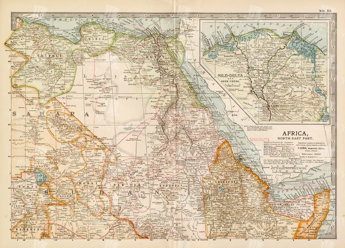
Vintage 1800s Map of North-East Africa Including Egypt, Sudan, and the Nile Delta – Antique Historical Map
This vintage map from the 1800s illustrates North-East Africa, including Egypt, Sudan, and the Nile Delta. The map is a beautiful representation of the region's historical geography, showing important cities, boundaries, and geographical features from the colonial era. A valuable piece for those interested in African history and cartography.
- Resolution: 7101 x 5100
- Image Type(s): JPG
- 1800s
- Africa
- Africa colonial
- Africa map
- Antique
- antique map
- Atlas
- boundaries
- cartography
- cities
- colonial era
- detailed
- Egypt
- exploration
- Geography
- historical
- historical geography
- historical map
- illustration
- Map
- Nile Delta
- North-East Africa
- old map
- preserved
- representation
- retro
- Rivers
- Sudan
- topography
- Travel
- vintage
- vintage map
- World
From this collection


Antique Illustration of a Bee with Detailed Wing and Body Structure from the 1800s
This 1800s vintage illustration depicts a bee with highly detailed wings and body, exemplifying the insect's anatomy in historical natural history art.
- Resolution: 1079px x 1251px
- Image Type(s): PNG
Related Images

Antique Map of Washington State
Antique map of Washington State, featuring towns, counties, railroads, and geographical features such as rivers and mountains. 19th century cartography highlighting the development and infrastructure of the state.
- Resolution: 7278 x 5100
- Image Type(s): JPG
- 19th-century
- American history
- Antique
- archival
- Atlas
- cartographer
- cartography
- classic
- collectible
- counties
- detailed map
- education
- exploration
- geographical features
- Geography
- heritage
- historical
- historical map
- historical washington
- History
- infrastructure
- Map
- Mountains
- northwest history
- nostalgic
- old map
- pacific northwest
- railroads
- reference
- representation
- Rivers
- state boundaries
- state development
- towns
- transportation
- USA
- vintage
- Washington
- washington geography
- washington map
- washington state
- World
From this collection

19th Century Map of Switzerland, Liechtenstein, and Parts of Austria-Hungary
A detailed antique map from the 19th century showcasing Switzerland, Liechtenstein, and parts of Austria-Hungary. The map highlights the mountainous terrain, lakes, and major cities, reflecting the historical borders and settlements of the region.
- Resolution: 7267 x 5100
- Image Type(s): JPG
From this collection

Antique Tan Paper Texture Scan No.1
- License Info
- Resolution: 5745px x 5745px
From this collection

Detailed Line Art Illustration of an Old Locomotive
A detailed vintage line art illustration of an old locomotive, showcasing the intricate design and mechanical components of historic trains.
- Image Type(s): PNG
Related Images

Vintage Map of Montana
An antique map showcasing the state of Montana, highlighting counties, cities, and geographical features in fine detail, typical of late 19th to early 20th century cartography.
- Resolution: 7235 x 5100
- Image Type(s): JPG
From this collection
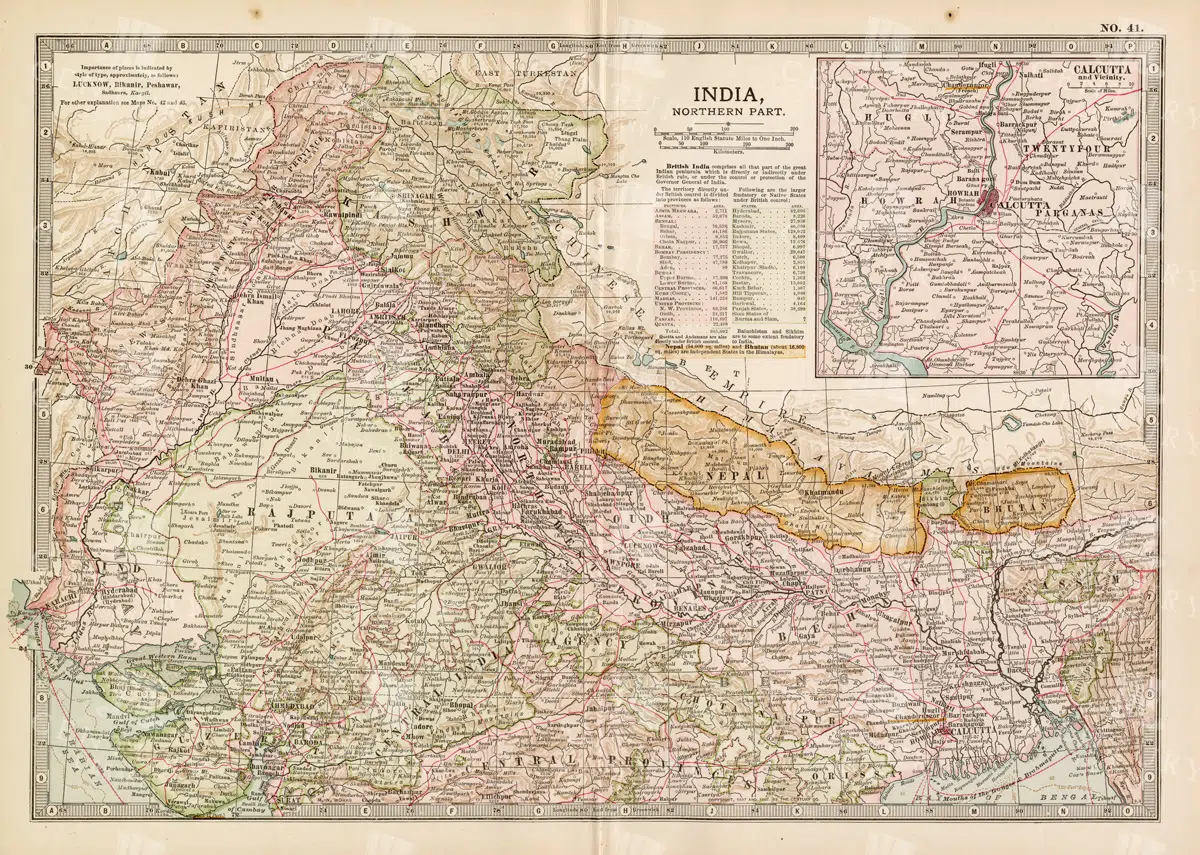
Historical Map of Northern India and Nepal Featuring Mountainous Terrain
Historical Map of Northern India and Nepal Featuring Mountainous Terrain
- Resolution: 7144 x 5100
- Image Type(s): JPG
- Antique
- antique map
- Atlas
- cartography
- cities
- colonial
- early 20th century
- exploration
- Geography
- Globe
- Himalayas
- historical
- historical geography
- historical map
- History
- Landscape
- Map
- mountainous terrain
- Navigation
- Nepal
- Northern India
- old
- old map
- political boundaries
- representation
- Rivers
- South Asia
- South Asian history
- topography
- transportation
- World
From this collection
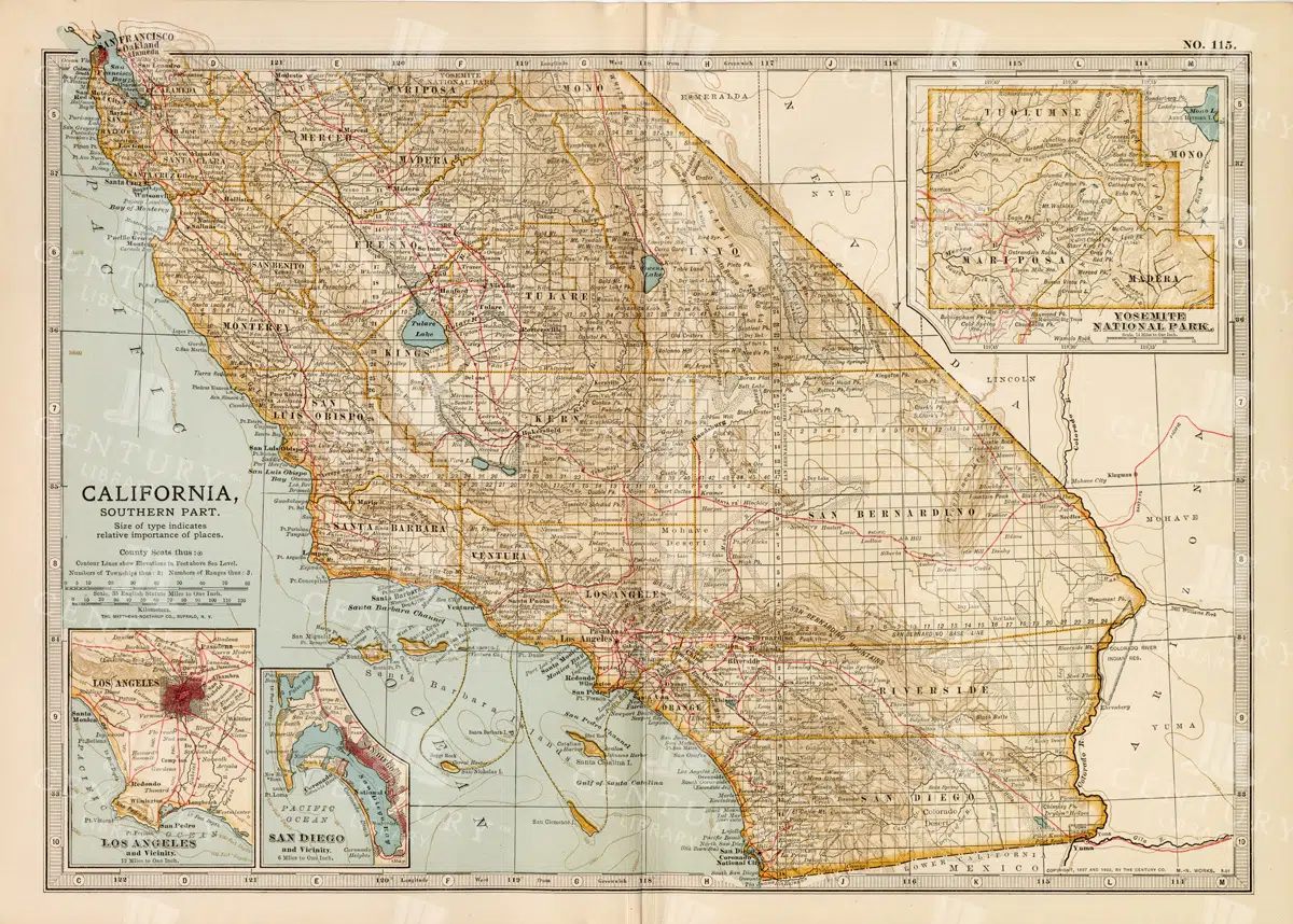
Vintage Map of Southern California Featuring Los Angeles and San Diego
This vintage map showcases the southern part of California, including major cities like Los Angeles and San Diego. The map highlights important transportation routes, natural landmarks, and the region's historical and geographical features.
- Resolution: 7114 x 5100
- Image Type(s): JPG
From this collection

Antique 1800s Map of Arkansas with Detailed County Lines and Natural Features – Vintage Historical Cartography
An antique map from the 1800s showcasing Arkansas, with detailed county lines and natural features. This vintage map provides a historical view of Arkansas’s geography during the 19th century, offering a beautifully preserved piece of the state’s cartographic history.
- Resolution: 7108 x 5100
- Image Type(s): JPG
From this collection

RARE 19th Century Decorative Art print – Vegetable Subject Friezes
- License Info
- Resolution: 10977px x 15480px
- Year of Print: 1866
- Artist: Michel Lienard
From this collection

Antique Royal Badge / Shield Illustration with Crown No.1
- License Info
- Resolution: 1848px x 2165px
Related Images

Detailed 19th Century Map of Illinois, USA
A richly detailed 19th century map of Illinois, focusing on the southern part of the state, including the area around Chicago and St. Louis. The map is intricately detailed with towns, railways, and geographical features, showcasing the state’s development during the period.
- Resolution: 7265 x 5100
- Image Type(s): JPG
- 19th-century
- America
- Antique
- antique map
- archives
- Atlas
- Borders
- cartography
- Chicago
- counties
- country
- development
- Engineering
- exploration
- Geography
- heritage
- historic
- historical
- History
- Illinois
- landmarks
- Map
- Midwest
- old map
- railways
- reference
- representation
- retro
- Rivers
- Rural
- settlements
- southern Illinois
- St. Louis
- territorial
- topographic
- topography
- towns
- transportation
- urban
- USA
- vintage
- World
From this collection

Antique 19th Century Map of Southern Ohio Featuring Major Cities and Rivers
A detailed 19th-century map showcasing Southern Ohio, highlighting cities like Cincinnati and Cleveland, along with rivers and other key geographical features. Ideal for historical and geographical studies.
- Resolution: 7248 x 5100
- Image Type(s): JPG
From this collection

Aged with Beautiful Petina – Antique Handwritten Book Scan No.5
- License Info
- Resolution: 9365px x 7707px
From this collection

Heraldic Salamander in Flames Vintage Illustration
An isolated PNG image of a salamander engulfed in flames, rendered in a vintage heraldic style. This mythical creature is often associated with fire, transformation, and resilience in heraldic traditions. Perfect for use in designs that explore mythological or alchemical themes.
- Resolution: 1022 x 795
- Image Type(s): PNG
Related Images

Heraldic Swan in Vintage Medieval Style
An isolated PNG image of a swan, rendered in a vintage medieval style. The swan is detailed with elegant plumage and a regal posture, often representing purity, grace, and nobility in heraldic traditions. This illustration is perfect for adding a touch of classic elegance to any design project.
- Resolution: 1428 x 1799
- Image Type(s): PNG
Related Images

1897 Map of Kentucky Featuring Counties, Railways, and Rivers
This 1897 map of Kentucky highlights the state's counties, railways, and rivers, offering a detailed look at the region's geography and infrastructure during the late 19th century. The map serves as a valuable resource for understanding Kentucky's development, with a focus on transportation and regional divisions. The vintage cartography style enhances its historical significance.
- Resolution: 7157 x 5100
- Image Type(s): JPG
From this collection

Historical Map of Idaho and Wyoming Including Yellowstone National Park
This historical map covers the states of Idaho and Wyoming, with a special focus on Yellowstone National Park. The map details the topographical features, including mountains, rivers, and forests, as well as the transportation routes and political boundaries of the early 20th century. It provides a valuable snapshot of the American West during this period, highlighting the natural beauty and geographical diversity of the region.
- Resolution: 7141 x 5100
- Image Type(s): JPG
- American West
- Antique
- antique map
- cartography
- conservation
- early 20th century
- exploration
- forests
- Geography
- historical
- historical geography
- historical map
- History
- Idaho
- Landscape
- Map
- Mountains
- national parks
- old
- old map
- political boundaries
- representation
- Rivers
- topography
- transportation
- United States
- vintage
- Western states
- Wyoming
- Yellowstone National Park
From this collection

Antique Map of the Chinese Empire Highlighting Major Regions and Cities
This antique map of the Chinese Empire highlights the major regions and cities, offering a detailed view of the empire's geographical and political structure. The map also includes insets of significant areas like Hong Kong and Peking, providing historical context.
- Resolution: 7119 x 5100
- Image Type(s): JPG
From this collection

Archangel Michael Defeating the Devil Vintage Heraldry
A dramatic isolated PNG image of Archangel Michael defeating the devil, rendered in a vintage heraldic style. This powerful image is rich in symbolism, often representing the triumph of good over evil. Ideal for use in religious, historical, or mythological design projects.
- Resolution: 944 x 1231
- Image Type(s): PNG
Related Images

Vintage Decorative Line Art Illustration – Floral – Border – Frame – Pattern No.66
- License Info
- Resolution: 5541px x 8883px
Related Images

Aged with Beautiful Petina – Antique Handwritten Book Scan No.10
- License Info
- Resolution: 9574px x 7785px
From this collection

Penny Farthing Line Art Illustration
A vintage line art illustration of a penny farthing bicycle, showcasing its iconic large front wheel design. Ideal for transportation and historical-themed projects.
- Image Type(s): PNG
Related Images

A Detailed Vintage Line Art Illustration of a Horned Viper Snake
A detailed vintage line art illustration of a horned viper snake, captured in an isolated format. Ideal for nature and wildlife-themed designs.
- Image Type(s): PNG
Related Images

Vintage Illustration of Bats Flying in the Night Sky from the 1800s
An antique illustration depicting bats flying against a night sky, highlighting their silhouettes and nocturnal behavior, common in 1800s natural history art.
- Resolution: 3143px x 3645px
- Image Type(s): PNG
Related Images
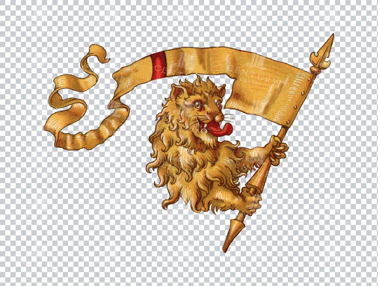
Vintage Heraldic Lion Holding a Banner Illustration
An isolated PNG image of a vintage heraldic lion holding a decorative banner. The lion is drawn in a classic style, often seen in traditional coats of arms. The banner flows gracefully, adding a sense of motion to the image. Perfect for historical, fantasy, or medieval-themed designs.
- Resolution: 2318 x 1754
- Image Type(s): PNG
Related Images

Antique Map of North Dakota
A historic map of North Dakota from the late 19th century, detailing the state's counties, cities, and major geographical landmarks, reflecting its development and settlement patterns.
- Resolution: 7244 x 5100
- Image Type(s): JPG
From this collection

Decorative Rectangular Tile Design with Oval Centre Containing Lady Justice Holding a Sword and Scales
A vintage line art tile design featuring Lady Justice with a sword and scales in an oval center, symbolizing law and fairness, perfect for legal-themed visuals.
- Image Type(s): PNG
Related Images

Detailed 1800s Illustration of Deer Antlers from Natural History Book
An antique illustration showing detailed and labeled deer antlers, typical of educational content found in 1800s natural history books, emphasizing anatomical details.
- Resolution: 2686px x 3221px
- Image Type(s): PNG
Related Images
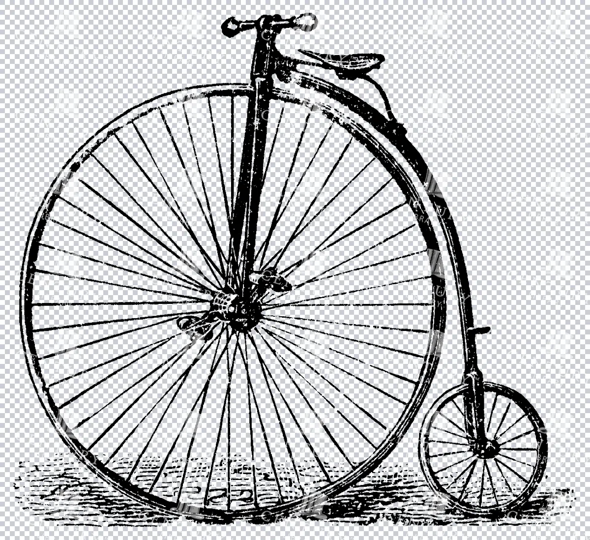
Antique Line Art Illustration of a Penny Farthing Bicycle
A vintage line art illustration of a penny farthing bicycle, showcasing its iconic large front wheel design. Ideal for transportation and historical-themed projects.
- Image Type(s): PNG
Related Images

Support the Library
Our supporters and members help us continue collecting and restoring these wonderful pieces of art for the modern creator
Unlock Everything and Become a Member!
While a lot of the library is available for free, some is kept behind closed dusty doors only to be accessed by our lovely members.