
STUNNING Owen Jones Original Print – Persian No 4b – Antique 1865
- License Info
- Resolution: 7530px x 11691px
- Year of Print: 1865
- Artist: Owen Jones
From this collection
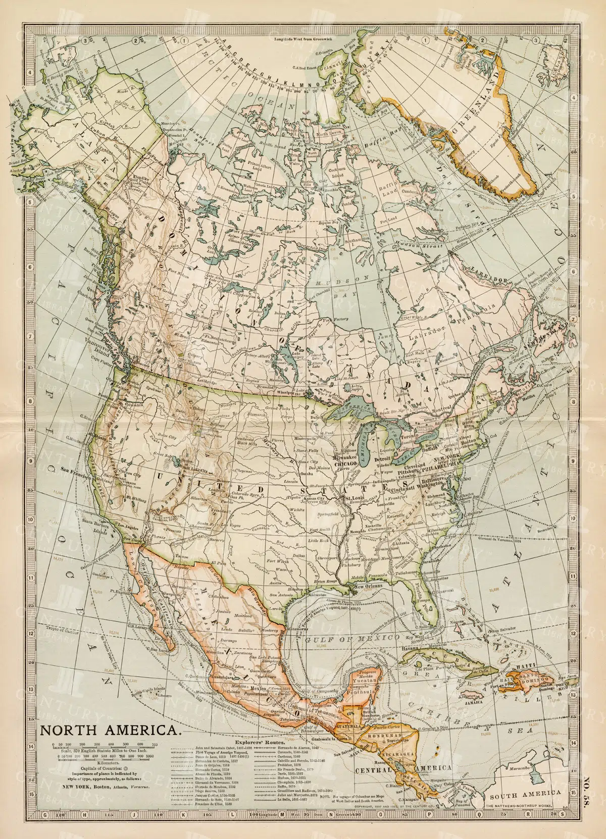
Vintage Map of North America
A historic map of North America, offering a comprehensive view of the continent's geography, including the United States, Canada, and Mexico, from the late 19th century.
- Resolution: 7242 x 5100
- Image Type(s): JPG
From this collection

BEAUTIFUL Owen Jones Antique Print – Indian No 6 – Vintage 1865
- License Info
- Resolution: 7486px x 11709px
- Year of Print: 1865
- Artist: Owen Jones
From this collection

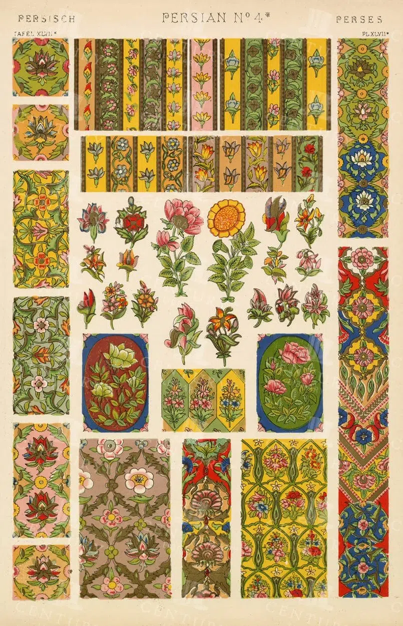
STUNNING Owen Jones Original Print – Persian No 4 – Antique 1865
- License Info
- Resolution: 7647px x 11702px
- Year of Print: 1865
- Artist: Owen Jones
From this collection

Elegant Ornate Frames and Borders Collection with 19th Century Designs
This set includes beautifully restored 19th-century frames and borders, perfect for adding a touch of vintage elegance to your projects. Each frame showcases intricate designs with floral and decorative motifs, crafted with precision and offered in a high-resolution PNG format with transparent backgrounds. Great for use in invitations, certificates, digital art, or as design elements for vintage-inspired works.
- Image Type(s): PNG
- decorative motifs
- ornate borders
- high resolution
- invitations
- restoration
- repurposed
- classic style
- certificates
- design elements
- frame collection
- restored
- 19th-century
- historical
- traditional
- detailed
- elegant
- transparent
- PNG
- heritage
- classic
- old-fashioned
- baroque
- art deco
- card
- vintage
- retro
- Antique
- Layout
- Design
- Rococo
- Ornate
- Frames
- Intricate
- Borders
- Floral
- Decorative
From this collection

Antique Map of the United States
Detailed antique map of the United States showing states, territories, railroads, and cities, with inset of Alaska. Includes topographical features, rivers, and mountain ranges.
- Resolution: 7275 x 5100
- Image Type(s): JPG
- state lines
- united states map
- nostalgic
- america map
- cartographer
- reference
- archival
- USA
- topographical
- mountain ranges
- railroads
- cities
- antique map
- historical map
- territories
- exploration
- old map
- cartography
- vintage map
- American history
- transportation
- states
- historic
- education
- 19th-century
- collectible
- historical
- detailed
- heritage
- illustration
- vintage
- Atlantic Ocean
- Antique
- History
- Alaska
- Pacific Ocean
- Geography
- United States
- America
- Rivers
- Map
- Borders
From this collection

Green Ornate Frame with Wide Borders
A green ornate frame with wide borders and detailed decorations, suitable for certificates, invitations, or decorative use.
- Image Type(s): PNG
- illustrative
- decorativeart
- fine
- official
- wide
- ornateart
- decorations
- embellished
- symmetrical
- traditional
- detailed
- artistic
- certificate
- elegant
- heritage
- classic
- old-fashioned
- formal
- Green
- creation
- vintage
- retro
- representation
- Patterned
- Photograph
- Invitation
- Engraving
- Art
- Design
- Graphic
- Outline
- Decoration
- Ornate
- Geometric
- Borders
- Border
- Floral
- Frame
- Decorative
From this collection


Historic Map of Oceanica Including Australia, New Zealand, and Pacific Islands
An extensive historical map of Oceanica, encompassing Australia, New Zealand, and various Pacific Islands. This 19th-century map details major routes, colonial regions, and key geographical features.
- Resolution: 7246 x 5100
- Image Type(s): JPG
From this collection

RUSSIAN Ornamental Border and Frame Art RACINET Vintage Stock Art
Here we have an original vintage print from the Auguste Racinet L'ornement Polycrome (1870) series. One of the finest collections of decorative arts from the 19th century, refered to for inspiration by many modern creators. Many interesting and useful design elements are waiting to be explored in this one piece! The purpose of the fantastic reproductions in L'Ornement polychrome were to inspire an improvement of the decorative arts of its time.
- License Info
- Resolution: 12433 x 17740 300dpi
- Year of Print: Estimated 1873
- Artist: Auguste Racinet
From this collection

Detailed 19th Century Map of the Netherlands, Belgium, and Luxembourg
A detailed antique map from the 19th century featuring the Netherlands, Belgium, and Luxembourg. The map showcases the geographical and political landscape of the region, including major cities, rivers, and borders.
- Resolution: 7271 x 5100
- Image Type(s): JPG
From this collection

Antique 19th Century Map of Norway and Sweden with Topographical Details
A beautifully detailed antique map from the 19th century showcasing the countries of Norway and Sweden, with topographical features, major cities, and inset maps of Kristiana and Stockholm.
- Resolution: 7245 x 5100
- Image Type(s): JPG
From this collection

Vintage Map of Southern England and Wales Highlighting Major Cities and Coastal Areas
This vintage map of Southern England and Wales highlights major cities, coastal areas, and important transportation routes. The map provides detailed insights into the region's historical geography and urban development during the period.
- Resolution: 7127 x 5100
- Image Type(s): JPG
From this collection

Vintage Styled Decorative Frame with Delicate Circular and Linear Patterns
This vintage styled decorative frame combines delicate circular and linear patterns with ornate corner details, set on a light beige textured background. The elegant and intricate design elements make this frame ideal for vintage projects, adding a classic touch to invitations, documents, or artistic displays. Its understated elegance and refined detailing offer a timeless appeal.
- License Info
- Image Type(s): JPG
From this collection
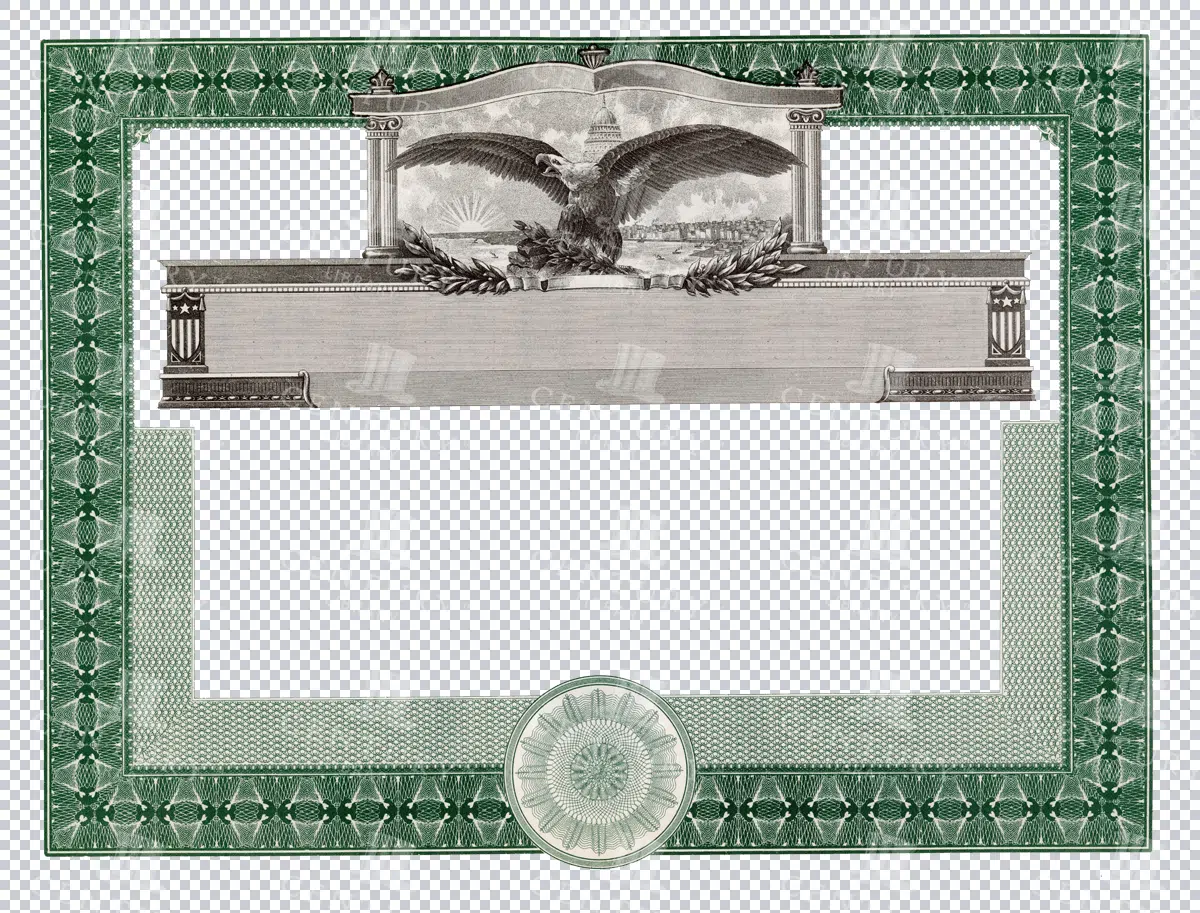
Eagle Motif Certificate Frame with Decorative Borders
A green certificate frame featuring an eagle motif at the top, surrounded by intricate decorative borders. Perfect for creating classic certificates or awards with a touch of grandeur and elegance.
- Image Type(s): PNG
From this collection

MIDDLE AGES Decorative Illumination Art RACINET Imp.Firmin Dedot Stock Art
Here we have an original vintage print from the Auguste Racinet L'ornement Polycrome (1870) series. One of the finest collections of decorative arts from the 19th century, refered to for inspiration by many modern creators. Many interesting and useful design elements are waiting to be explored in this one piece! The purpose of the fantastic reproductions in L'Ornement polychrome were to inspire an improvement of the decorative arts of its time.
- License Info
- Resolution: 11634 x 16420 300dpi
- Year of Print: Estimated 1873
- Artist: Auguste Racinet
From this collection

Detailed 19th Century Map of Texas, Eastern Part
A detailed map from the 19th century illustrating the eastern part of Texas, USA. The map features various towns, railroads, and natural landmarks, providing a glimpse into the state’s historical geography and development.
- Resolution: 7269 x 5100
- Image Type(s): JPG
From this collection

Antique Map of Vermont and New Hampshire
Detailed antique map showing the states of Vermont and New Hampshire with towns, railroads, rivers, and geographical features. Historical cartography showcasing 19th century state boundaries and infrastructures.
- Resolution: 7276 x 5100
- Image Type(s): JPG
- state lines
- nostalgic
- cartographer
- state boundaries
- infrastructures
- vermont map
- new hampshire map
- reference
- archival
- geographical features
- USA
- railroads
- detailed map
- historical map
- exploration
- old map
- cartography
- vintage map
- American history
- transportation
- states
- towns
- historic
- education
- 19th-century
- collectible
- historical
- heritage
- classic
- vintage
- representation
- Atlantic Ocean
- Antique
- History
- New England
- Vermont
- New Hampshire
- Geography
- Atlas
- Rivers
- Map
- Borders
From this collection

19th Century Map of Spain, Portugal, and Andorra
An antique map from the 19th century detailing the countries of Spain, Portugal, and Andorra, along with surrounding regions. The map features important cities, mountain ranges, and bodies of water, offering a glimpse into the historical geography of the Iberian Peninsula.
- Resolution: 7266 x 5100
- Image Type(s): JPG
- 19th-century
- Andorra
- Antique
- archives
- Atlantic
- Atlas
- Borders
- cartography
- cities
- country
- Europe
- exploration
- Geography
- heritage
- historic map
- historical
- History
- Iberian Peninsula
- landmarks
- Landscape
- Map
- Mediterranean
- Mountains
- old map
- Portugal
- Pyrenees
- reference
- representation
- retro
- Rivers
- settlements
- Spain
- topographic
- vintage
- vintage map
- World
From this collection

Antique Map of Philippine Islands and Hawaiian Islands with Inset Maps
A detailed 19th-century map showcasing the Philippine Islands and Hawaiian Islands, complete with inset maps of major cities like Manila and Honolulu. This map is ideal for historical and geographical research.
- Resolution: 7254 x 5100
- Image Type(s): JPG
From this collection
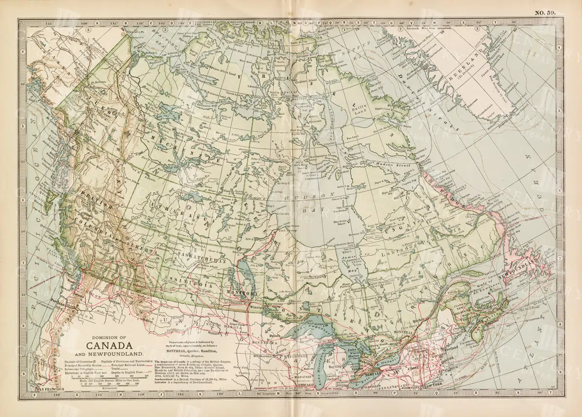
Antique Map of Canada and Newfoundland Highlighting Major Cities and Natural Features
An antique map of Canada and Newfoundland, offering a detailed look at the region's cities, natural landmarks, and geographical features. The map provides insights into the historical significance of the area during the time of its creation.
- Resolution: 7115 x 5100
- Image Type(s): JPG
From this collection

RUSSIAN Border and Frame Embellishment Design RACINET Vintage Plate
Here we have an original vintage print from the Auguste Racinet L'ornement Polycrome (1870) series. One of the finest collections of decorative arts from the 19th century, refered to for inspiration by many modern creators. Many interesting and useful design elements are waiting to be explored in this one piece! The purpose of the fantastic reproductions in L'Ornement polychrome were to inspire an improvement of the decorative arts of its time.
- License Info
- Resolution: 12433 x 17740 300dpi
- Year of Print: Estimated 1873
- Artist: Auguste Racinet
From this collection

19th Century Map of the Balkan Peninsula and Turkey in Europe
An antique map from the 19th century illustrating the Balkan Peninsula and Turkey in Europe, including regions like Bulgaria, Romania, Serbia, and Montenegro. The map offers a detailed view of the historical geography of Southeastern Europe.
- Resolution: 7274 x 5100
- Image Type(s): JPG
From this collection

RUSSIAN Border and Frame Embellishment Design RACINET Vintage Artwork
Here we have an original vintage print from the Auguste Racinet L'ornement Polycrome (1870) series. One of the finest collections of decorative arts from the 19th century, refered to for inspiration by many modern creators. Many interesting and useful design elements are waiting to be explored in this one piece! The purpose of the fantastic reproductions in L'Ornement polychrome were to inspire an improvement of the decorative arts of its time.
- License Info
- Resolution: 13087 x 18674 300dpi
- Year of Print: Estimated 1873
- Artist: Auguste Racinet
From this collection

Vintage Map of Southern England Including London, Brighton, and Major Coastal Cities
A vintage map of Southern England, highlighting major cities like London and Brighton, as well as coastal areas. The map provides detailed insights into the region's historical geography, transportation routes, and urban development.
- Resolution: 7129 x 5100
- Image Type(s): JPG
From this collection

Antique Map of Northern Ohio with Detailed City and County Lines
A historic map from the late 19th century detailing Northern Ohio, including major cities, counties, and transportation routes. This antique map highlights the region's development and infrastructure.
- Resolution: 7247 x 5100
- Image Type(s): JPG
From this collection

Antique Map of Mexico Showing Topography and Major Cities
An antique map of Mexico displaying the topography, major cities, and transportation routes, with a focus on the geographical diversity and historical boundaries from the early 20th century.
- Resolution: 7163 x 5100
- Image Type(s): JPG
From this collection

Antique Map of Turkey in Asia with Russian Trans-Caucasia
A richly detailed antique map from the 19th century depicting Turkey in Asia, including regions like Anatolia, Armenia, Kurdistan, Mesopotamia, and Syria, along with parts of Russian Trans-Caucasia. The map highlights historical borders and settlements.
- Resolution: 7273 x 5100
- Image Type(s): JPG
From this collection
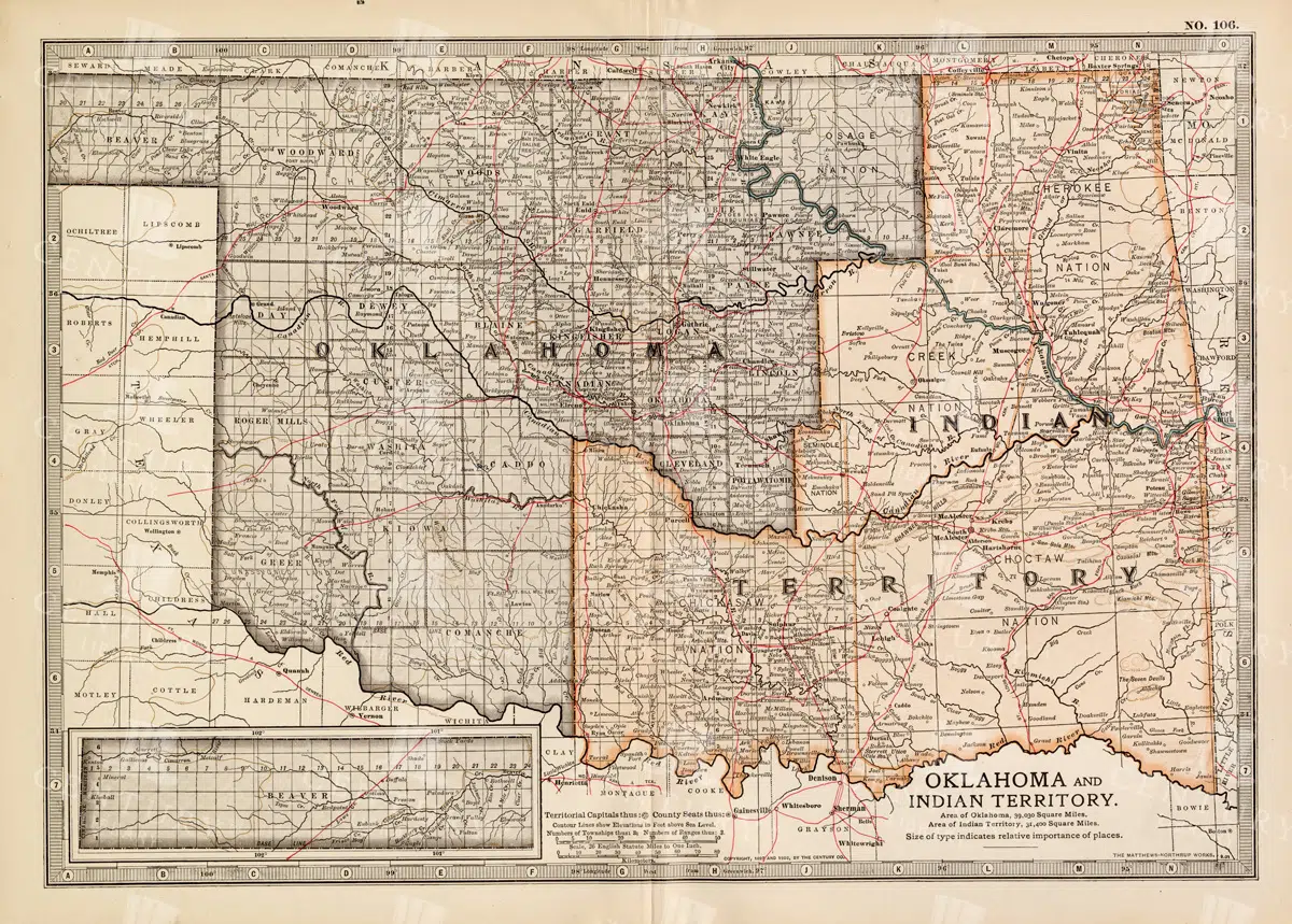
Antique Map of Oklahoma and Indian Territory from the 19th Century
This antique map from the 19th century illustrates Oklahoma and Indian Territory, showcasing the regions before statehood. It details the counties, settlements, and major transportation routes of the time.
- Resolution: 7249 x 5100
- Image Type(s): JPG
From this collection

Historic Map of New Jersey
A detailed antique map of New Jersey, highlighting its counties, cities, and significant landmarks, reflecting the state's geography and development during the late 19th century.
- Resolution: 7239 x 5100
- Image Type(s): JPG
From this collection
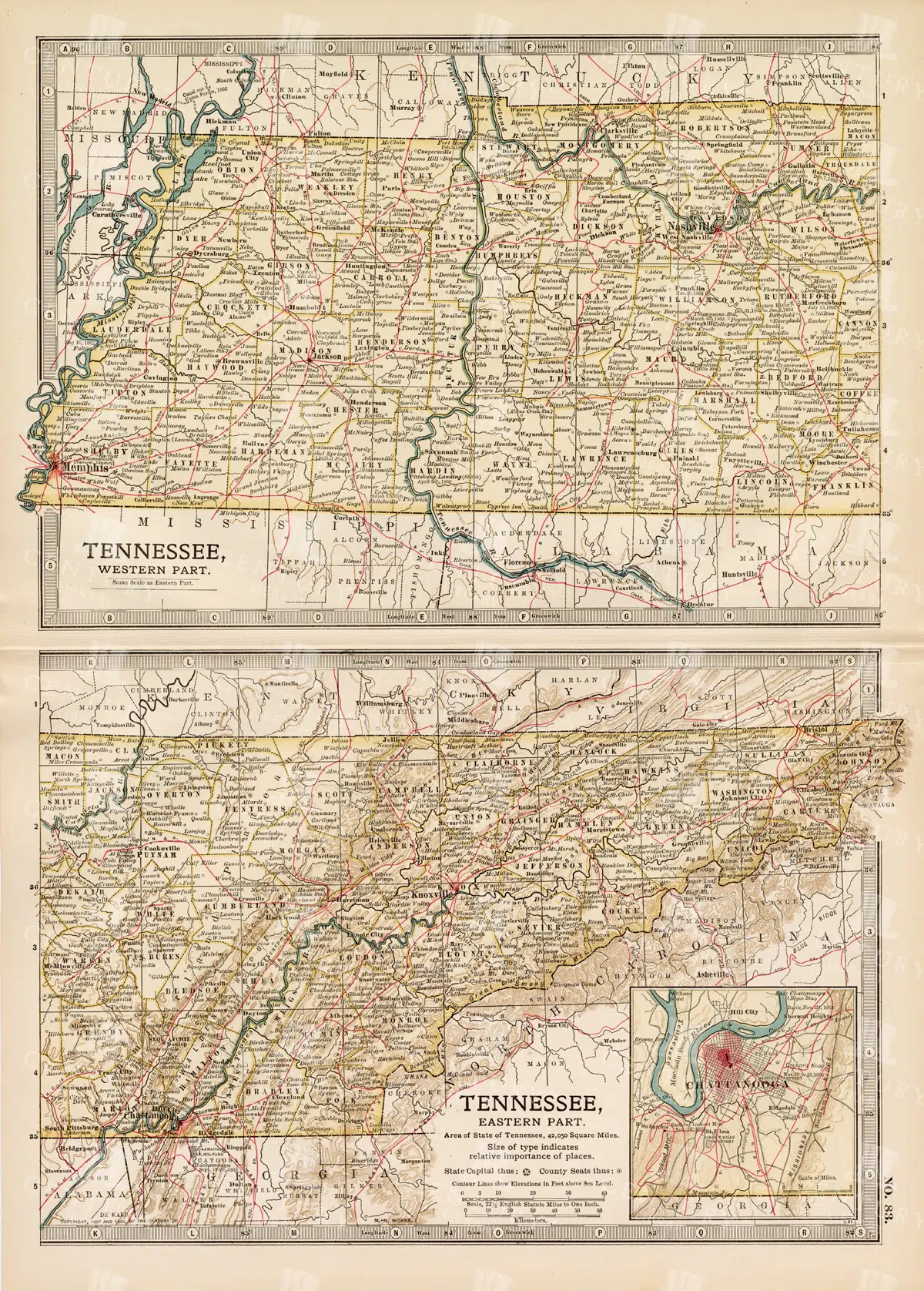
Antique Map of Tennessee, USA – Eastern and Western Parts
An antique map from the 19th century depicting both the eastern and western parts of Tennessee, USA. The map shows various towns, railways, and natural features, providing a comprehensive view of the state’s geography and development during the period.
- Resolution: 7268 x 5100
- Image Type(s): JPG
From this collection

Vintage Map of Nevada and Utah
An antique map detailing the states of Nevada and Utah, showcasing the topography, settlements, and infrastructure from the late 19th to early 20th century, with insets of major cities.
- Resolution: 7237 x 5100
- Image Type(s): JPG
From this collection

Detailed 19th Century Map of Ontario with Inset of Toronto and Vicinity
A richly detailed map of Ontario from the late 19th century, featuring county divisions, cities, and a prominent inset of Toronto and its surrounding areas, highlighting important transportation routes.
- Resolution: 7250 x 5100
- Image Type(s): JPG
From this collection

Antique Map of New Brunswick, Nova Scotia, and Prince Edward Island
A historic map from the late 19th century illustrating the Canadian provinces of New Brunswick, Nova Scotia, and Prince Edward Island, featuring key cities, towns, and geographical landmarks.
- Resolution: 7238 x 5100
- Image Type(s): JPG
- 19th-century
- Antique
- Atlantic
- Atlas
- Borders
- Canada
- cartography
- cities
- classic
- coastline
- colonial
- country
- Geography
- Globe
- heritage
- History
- illustration
- Landscape
- Map
- maritime
- new brunswick
- novascotia
- Ocean
- princeed ward island
- provinces
- regions
- representation
- Rivers
- Road
- settlements
- territory
- topography
- tourism
- towns
- Travel
- vintage
- World
From this collection

Historical Map of Manitoba, British Columbia, and the Northwest Territories
A detailed historical map depicting the regions of Manitoba, British Columbia, and the Northwest Territories, showcasing topographical features, settlements, and boundaries in the early 20th century.
- Resolution: 7160 x 5100
- Image Type(s): JPG
- topographical
- northwest
- columbia
- manitoba
- settlements
- early
- 20th
- demographics
- century
- provincial
- division
- resources
- settlement
- climate
- infrastructure
- regions
- boundaries
- colonial
- territories
- exploration
- cartography
- transportation
- coastline
- historical
- natural
- vintage
- representation
- Antique
- History
- River
- Geography
- Atlas
- British
- World
- Landscape
- Canada
- Globe
- Map
- Travel
- Borders
From this collection

Vintage Map of Northern England and Wales Highlighting Major Cities and Geographic Features
A vintage map of Northern England and Wales, detailing major cities, towns, and geographical features. The map includes important transportation routes and provides a historical overview of the region during the period.
- Resolution: 7125 x 5100
- Image Type(s): JPG
From this collection

Antique Map of Western Pennsylvania from the 19th Century with Pittsburgh Inset
This antique map highlights Western Pennsylvania from the 19th century, featuring cities, counties, and transportation routes. Includes an inset of Pittsburgh and its vicinity, showcasing urban growth.
- Resolution: 7252 x 5100
- Image Type(s): JPG
From this collection

Historic Map of North Carolina
A detailed antique map of North Carolina, highlighting its counties, cities, and key geographical features, showcasing the state's landscape during the late 19th century.
- Resolution: 7243 x 5100
- Image Type(s): JPG
From this collection

Antique Map of Western New York
A detailed historic map showcasing the western part of New York, highlighting counties, cities, and geographical features, including insets of major urban areas like Buffalo and Rochester.
- Resolution: 7241 x 5100
- Image Type(s): JPG
From this collection

Vintage Map of Northern New York
An antique map focusing on the northern and eastern parts of New York, showing the state's counties, cities, and significant natural features, typical of late 19th-century cartography.
- Resolution: 7240 x 5100
- Image Type(s): JPG
From this collection

Empire of Austria-Hungary Historical Map with Detailed Regional Boundaries and Railways
This historical map of the Austria-Hungary Empire showcases detailed regional boundaries, cities, and extensive railway networks. The map includes significant areas like Budapest and Vienna, providing a comprehensive view of the empire's geographical and political landscape during the period.
- Resolution: 7112 x 5100
- Image Type(s): JPG
From this collection

Antique Historical Map of Western Austria-Hungary Featuring Vienna and Prague
An antique map of the western part of Austria-Hungary, highlighting major cities like Vienna and Prague. The map provides intricate details of regional boundaries, railway networks, and topographical features, reflecting the historical political landscape of the region.
- Resolution: 7111 x 5100
- Image Type(s): JPG
From this collection

Detailed 19th Century Map of Eastern Pennsylvania with Philadelphia Inset
A historic map from the 19th century depicting Eastern Pennsylvania, including detailed county lines, cities, and an inset of Philadelphia. This map captures the region's development and growth.
- Resolution: 7253 x 5100
- Image Type(s): JPG
From this collection

Antique 19th Century Map of Oregon Featuring Detailed Topographical Features
A detailed antique map from the 19th century showcasing the state of Oregon, including its mountains, rivers, and settlements. This map highlights the state's topography and early infrastructure development.
- Resolution: 7251 x 5100
- Image Type(s): JPG
From this collection

19th Century Map of Switzerland, Liechtenstein, and Parts of Austria-Hungary
A detailed antique map from the 19th century showcasing Switzerland, Liechtenstein, and parts of Austria-Hungary. The map highlights the mountainous terrain, lakes, and major cities, reflecting the historical borders and settlements of the region.
- Resolution: 7267 x 5100
- Image Type(s): JPG
From this collection

Detailed 19th Century Map of Illinois, USA
A richly detailed 19th century map of Illinois, focusing on the southern part of the state, including the area around Chicago and St. Louis. The map is intricately detailed with towns, railways, and geographical features, showcasing the state’s development during the period.
- Resolution: 7265 x 5100
- Image Type(s): JPG
- St. Louis
- southern Illinois
- archives
- reference
- territorial
- topographic
- USA
- development
- settlements
- Midwest
- topography
- antique map
- exploration
- old map
- cartography
- transportation
- railways
- counties
- landmarks
- towns
- historic
- 19th-century
- historical
- heritage
- urban
- country
- vintage
- retro
- representation
- Antique
- Rural
- History
- Chicago
- Illinois
- Geography
- Atlas
- World
- Engineering
- America
- Rivers
- Map
- Borders
From this collection

Antique 19th Century Map of Southern Ohio Featuring Major Cities and Rivers
A detailed 19th-century map showcasing Southern Ohio, highlighting cities like Cincinnati and Cleveland, along with rivers and other key geographical features. Ideal for historical and geographical studies.
- Resolution: 7248 x 5100
- Image Type(s): JPG
From this collection

Vintage Map of Montana
An antique map showcasing the state of Montana, highlighting counties, cities, and geographical features in fine detail, typical of late 19th to early 20th century cartography.
- Resolution: 7235 x 5100
- Image Type(s): JPG
From this collection
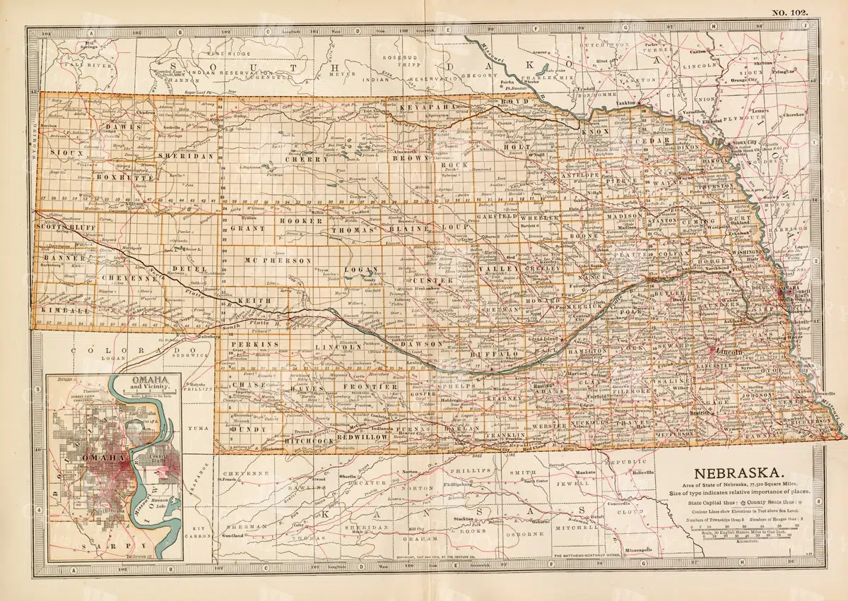
Historic Map of Nebraska
A detailed historic map of Nebraska, illustrating counties, towns, and important routes, reflecting the geography and infrastructure of the state during the late 19th to early 20th century.
- Resolution: 7236 x 5100
- Image Type(s): JPG
From this collection

Antique Map of North Dakota
A historic map of North Dakota from the late 19th century, detailing the state's counties, cities, and major geographical landmarks, reflecting its development and settlement patterns.
- Resolution: 7244 x 5100
- Image Type(s): JPG
From this collection

Support the Library
Our supporters and members help us continue collecting and restoring these wonderful pieces of art for the modern creator
Unlock Everything and Become a Member!
While a lot of the library is available for free, some is kept behind closed dusty doors only to be accessed by our lovely members.