

19th Century World Map – Chief Countries and Their Colonies
An antique world map from the 19th century showcasing chief countries and their colonies during the period. The map uses Mercator's projection and highlights the global political landscape, including colonial possessions.
- Resolution: 7272 x 5100
- Image Type(s): JPG
From this collection
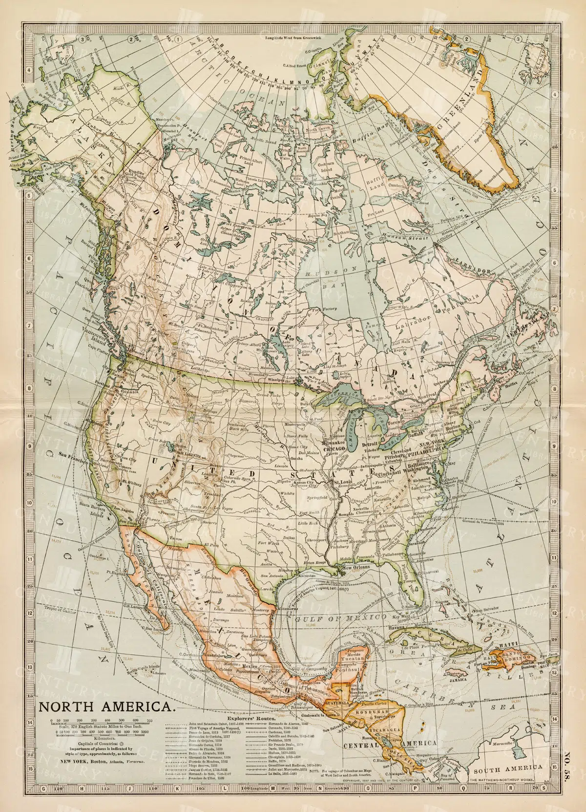
Vintage Map of North America
A historic map of North America, offering a comprehensive view of the continent's geography, including the United States, Canada, and Mexico, from the late 19th century.
- Resolution: 7242 x 5100
- Image Type(s): JPG
From this collection

Vintage Hot Air Balloon Flight with Aristocrats Over Countryside
A Charming Mix of Vintage Illustrations – Pastoral Scenes, Mythical Figures & More This image is part of a collection packed with beautifully restored vintage toile de jouy style illustrations. Think peaceful countryside scenes, graceful mythological figures, farm animals, and a good dose of that old-timey charm. Whether you’re into junk journaling, crafting, branding, or just love adding a touch of vintage to your creative projects, there’s loads to play with here. You’ll find everything from shepherd boys and garden goddesses to hot air balloons, dancing villagers, and elegant birds - all cleaned up and ready to use. Perfect for print, digital, or anything in between, this set brings a slice of history into your modern designs with plenty of character and detail.
- Image Type(s): PNG
From this collection

Antique Map of the United States
Detailed antique map of the United States showing states, territories, railroads, and cities, with inset of Alaska. Includes topographical features, rivers, and mountain ranges.
- Resolution: 7275 x 5100
- Image Type(s): JPG
- 19th-century
- Alaska
- America
- america map
- American history
- Antique
- antique map
- archival
- Atlantic Ocean
- Borders
- cartographer
- cartography
- cities
- collectible
- detailed
- education
- exploration
- Geography
- heritage
- historic
- historical
- historical map
- History
- illustration
- Map
- mountain ranges
- nostalgic
- old map
- Pacific Ocean
- railroads
- reference
- Rivers
- state lines
- states
- territories
- topographical
- transportation
- United States
- united states map
- USA
- vintage
- vintage map
From this collection

Vintage Map of Ireland Highlighting Political Boundaries and Topographical Features
This vintage map of Ireland highlights the country's political boundaries and key topographical features, including rivers, mountains, and major cities. The map provides a historical overview of Ireland during the late 19th century, offering insight into the geopolitical landscape and cultural heritage of the island. It includes detailed insets of Dublin and its surrounding areas, reflecting Ireland's rich history and complex political past.
- Resolution: 7149 x 5100
- Image Type(s): JPG
- late 19th century
- geopolitical
- Irish history
- Ireland history
- cultural heritage
- topography
- cities
- historical geography
- antique map
- historical map
- exploration
- old map
- cartography
- political boundaries
- Dublin
- vintage
- representation
- Antique
- History
- Island
- Geography
- Atlas
- World
- Landscape
- Ireland
- Rivers
- Mountains
- Map
- United Kingdom
- Europe
From this collection

Historic Map of Oceanica Including Australia, New Zealand, and Pacific Islands
An extensive historical map of Oceanica, encompassing Australia, New Zealand, and various Pacific Islands. This 19th-century map details major routes, colonial regions, and key geographical features.
- Resolution: 7246 x 5100
- Image Type(s): JPG
From this collection

Detailed 19th Century Map of the Netherlands, Belgium, and Luxembourg
A detailed antique map from the 19th century featuring the Netherlands, Belgium, and Luxembourg. The map showcases the geographical and political landscape of the region, including major cities, rivers, and borders.
- Resolution: 7271 x 5100
- Image Type(s): JPG
From this collection

Vintage 1800s Map of Alaska Featuring Detailed Geography and Historical Boundaries – Antique Historical Map
An antique map from the 1800s featuring Alaska, highlighting its detailed geography and historical boundaries. This vintage map offers a glimpse into the early cartographic representation of Alaska, with intricate details of its natural features and political divisions. A perfect addition for those interested in Alaskan history and vintage maps.
- Resolution: 7105 x 5100
- Image Type(s): JPG
From this collection

Toile De Jouy Chinoiserie PNG Illustration with Ornamental Ruins, Astronomical Instruments, and Aristocrats
The image is 1 of 59 from the following collection: 'Discover Toile De Jouy’s gorgeous style within this meticulously edited collection of 59 isolated PNG illustrations. Inside, you'll discover a wonderfully detailed set of vintage illustrations with a subtle texture applied, making the illustration look like it has been printed with dark blue ink! It’s super effective and looks fantastic on light backgrounds.
- Image Type(s): PNG
From this collection

Antique 19th Century Map of Norway and Sweden with Topographical Details
A beautifully detailed antique map from the 19th century showcasing the countries of Norway and Sweden, with topographical features, major cities, and inset maps of Kristiana and Stockholm.
- Resolution: 7245 x 5100
- Image Type(s): JPG
From this collection
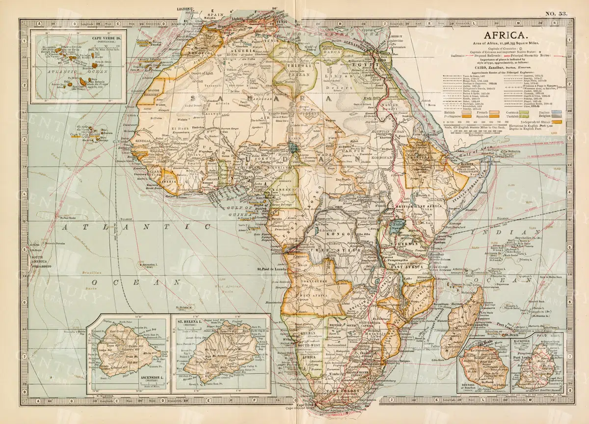
Antique 1800s Map of Africa Showing Entire Continent and Colonial Territories – Vintage Historical Cartography
This comprehensive antique map from the 1800s showcases the entire continent of Africa, highlighting colonial territories and geographical features. The map is a valuable historical document, offering insights into Africa's political and natural landscape during the colonial era. A beautifully detailed piece of vintage cartography.
- Resolution: 7104 x 5100
- Image Type(s): JPG
- 1800s
- Africa
- Africa colonial
- Africa history
- Africa map
- Antique
- antique map
- Atlas
- boundaries
- cartography
- colonial era
- colonial territories
- country
- detailed
- entire continent
- exploration
- Geography
- historical
- historical map
- History
- illustration
- Map
- natural features
- old map
- political map
- preserved
- representation
- retro
- topography
- vintage
- vintage map
- World
From this collection

Antique Map of the West Indies
Historical antique map of the West Indies, showcasing islands like Cuba, Jamaica, and Puerto Rico, with detailed nautical routes, ports, and topography. Includes inset of Bermuda. 19th century cartography.
- Resolution: 7279 x 5100
- Image Type(s): JPG
- nostalgic
- cartographer
- cuba
- puerto rico
- nautical routes
- ports
- bermuda
- islands map
- sea routes
- bermuda map
- west indies map
- island history
- archival
- Caribbean islands
- Caribbean
- detailed map
- maritime
- topography
- historical map
- exploration
- old map
- cartography
- transportation
- 19th-century
- collectible
- historical
- heritage
- classic
- Islands
- country
- vintage
- representation
- Atlantic Ocean
- Antique
- History
- Jamaica
- West Indies
- Geography
- Atlas
- World
- Map
- Nautical
From this collection

Vintage 1800s Map of Asia with Emphasis on Siberia and Central Asia – Antique Historical Map
A vintage map from the 1800s featuring Asia, with special emphasis on Siberia and Central Asia. The antique map showcases the vast geography, political boundaries, and natural features of the region, offering a detailed view of Asia during the 19th century. Perfect for those interested in Asian history and vintage cartography.
- Resolution: 7109 x 5100
- Image Type(s): JPG
From this collection

19th Century Map of the Balkan Peninsula and Turkey in Europe
An antique map from the 19th century illustrating the Balkan Peninsula and Turkey in Europe, including regions like Bulgaria, Romania, Serbia, and Montenegro. The map offers a detailed view of the historical geography of Southeastern Europe.
- Resolution: 7274 x 5100
- Image Type(s): JPG
From this collection

Detailed 19th Century Map of Texas, Eastern Part
A detailed map from the 19th century illustrating the eastern part of Texas, USA. The map features various towns, railroads, and natural landmarks, providing a glimpse into the state’s historical geography and development.
- Resolution: 7269 x 5100
- Image Type(s): JPG
From this collection

Klingert’s Diving Machine Diving Suit Antique Vintage Isolated PNG Lineart
A vintage line art illustration of Klingert's diving machine diving suit, captured in an isolated PNG format, perfect for historical and industrial-themed designs.
- Image Type(s): PNG
Related Images

Antique Map of Vermont and New Hampshire
Detailed antique map showing the states of Vermont and New Hampshire with towns, railroads, rivers, and geographical features. Historical cartography showcasing 19th century state boundaries and infrastructures.
- Resolution: 7276 x 5100
- Image Type(s): JPG
- 19th-century
- American history
- Antique
- archival
- Atlantic Ocean
- Atlas
- Borders
- cartographer
- cartography
- classic
- collectible
- detailed map
- education
- exploration
- geographical features
- Geography
- heritage
- historic
- historical
- historical map
- History
- infrastructures
- Map
- New England
- New Hampshire
- new hampshire map
- nostalgic
- old map
- railroads
- reference
- representation
- Rivers
- state boundaries
- state lines
- states
- towns
- transportation
- USA
- Vermont
- vermont map
- vintage
- vintage map
From this collection

Antique Map of Texas, Western Part with Galveston Bay
A vintage 19th century map depicting the western part of Texas along with a detailed inset of Galveston Bay, Houston, and surrounding areas. The map highlights the state’s development, including railroads, towns, and natural features.
- Resolution: 7270 x 5100
- Image Type(s): JPG
From this collection

19th Century Map of Spain, Portugal, and Andorra
An antique map from the 19th century detailing the countries of Spain, Portugal, and Andorra, along with surrounding regions. The map features important cities, mountain ranges, and bodies of water, offering a glimpse into the historical geography of the Iberian Peninsula.
- Resolution: 7266 x 5100
- Image Type(s): JPG
- 19th-century
- Andorra
- Antique
- archives
- Atlantic
- Atlas
- Borders
- cartography
- cities
- country
- Europe
- exploration
- Geography
- heritage
- historic map
- historical
- History
- Iberian Peninsula
- landmarks
- Landscape
- Map
- Mediterranean
- Mountains
- old map
- Portugal
- Pyrenees
- reference
- representation
- retro
- Rivers
- settlements
- Spain
- topographic
- vintage
- vintage map
- World
From this collection

Antique Map of Virginia
Historical antique map of Virginia, showing counties, towns, railroads, rivers, and geographical details. Includes insets of the western part of Virginia and the Norfolk vicinity. 19th century cartography.
- Resolution: 7277 x 5100
- Image Type(s): JPG
- 19th-century
- American history
- Antique
- archival
- Atlantic Ocean
- Atlas
- cartographer
- cartography
- classic
- collectible
- counties
- detailed map
- education
- exploration
- geographical details
- Geography
- heritage
- historic
- historical
- historical map
- historical regions
- History
- Map
- norfolk
- nostalgic
- old
- old map
- railroads
- reference
- representation
- Rivers
- state boundaries
- towns
- transportation
- USA
- vintage
- Virginia
- virginia counties
- virginia map
- western virginia
From this collection

Antique 1800s Map of North-West Africa Highlighting Morocco, Algeria, and Western Sahara – Vintage Historical Map
This antique map from the 1800s highlights North-West Africa, including Morocco, Algeria, and the Western Sahara. It captures the colonial and geographical landscape of the time, showing intricate details of the region’s political boundaries and natural features. A beautifully preserved piece of history in vintage cartography.
- Resolution: 7102 x 5100
- Image Type(s): JPG
- 1800s
- Africa
- Africa colonial
- Africa map
- Algeria
- Antique
- antique map
- Atlas
- cartography
- colonial
- colonial era
- country
- detailed
- exploration
- Geography
- Globe
- historical
- historical map
- History
- Map
- Morocco
- natural features
- Navigation
- North-West Africa
- old
- old map
- political boundaries
- preserved
- representation
- retro
- topography
- Travel
- vintage
- vintage map
- Western Sahara
- World
From this collection

1897 Map of New Zealand and Pacific Islands
This vintage 1897 map provides a detailed view of New Zealand and surrounding Pacific islands, including Samoa, Fiji, Tonga, and others. It illustrates the geographical and political boundaries of the region during the late 19th century, offering insight into the exploration and colonization of the Pacific. The map's historical significance is enhanced by its detailed cartography and the representation of various island groups.
- Resolution: 7150 x 5100
- Image Type(s): JPG
From this collection

Antique Map of Eastern India, Burma, Siam, and French Indo-China
This antique map showcases Eastern India, Burma (now Myanmar), Siam (now Thailand), and French Indo-China (Vietnam, Laos, Cambodia), with a focus on the geopolitical boundaries and major cities of the early 20th century. The map provides a detailed view of the region's topographical features, including rivers, mountain ranges, and coastlines, reflecting the historical context of Southeast Asia during this period.
- Resolution: 7143 x 5100
- Image Type(s): JPG
- Antique
- antique map
- Asia
- Atlas
- Burma
- cartography
- cities
- coastlines
- colonial
- country
- cultural heritage
- early 20th century
- Eastern India
- exploration
- French Indo-China
- Geography
- geopolitical boundaries
- historical geography
- historical map
- History
- Landscape
- Map
- mountain ranges
- old map
- representation
- Rivers
- Siam
- Southeast Asia
- topography
- World
From this collection
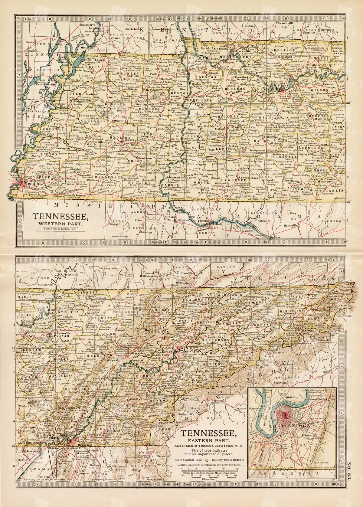
Antique Map of Tennessee, USA – Eastern and Western Parts
An antique map from the 19th century depicting both the eastern and western parts of Tennessee, USA. The map shows various towns, railways, and natural features, providing a comprehensive view of the state’s geography and development during the period.
- Resolution: 7268 x 5100
- Image Type(s): JPG
From this collection

Antique Map of West Virginia
Detailed antique map of West Virginia, showing counties, towns, railroads, and geographical features. Historical 19th century cartography with insets of surrounding areas. An educational and collectible piece.
- Resolution: 7280 x 5100
- Image Type(s): JPG
- 19th-century
- American history
- Antique
- archival
- Atlas
- cartographer
- cartography
- classic
- collectible
- counties
- detailed map
- education
- exploration
- geographical features
- Geography
- Globe
- heritage
- heritage map
- historical
- historical map
- historical regions
- History
- Map
- nostalgic
- old
- old map
- railroads
- reference
- representation
- state boundaries
- state map
- surrounding areas
- topography
- towns
- transportation
- USA
- vintage
- vintage west virginia
- West Virginia
- west virginia counties
- west virginia map
- World
From this collection
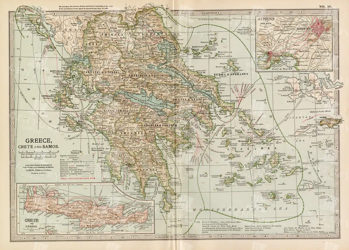
Antique Map of Greece Highlighting Crete and Samos with Detailed Topography
This antique map of Greece highlights the regions of Crete and Samos, showing detailed topographical features such as mountains, rivers, and coastlines. The map provides a historical overview of the geopolitical boundaries, major cities, and maritime routes in the Aegean Sea during the late 19th century. It offers a valuable perspective on the landscape and political divisions of Greece and its islands at the time.
- Resolution: 7140 x 5100
- Image Type(s): JPG
From this collection

Vintage 1800s Map of Southern Africa Including South Africa, Namibia, and Surrounding Territories – Antique Map
A vintage map from the 1800s depicting Southern Africa, including South Africa, Namibia, and surrounding territories. This antique map highlights the region’s colonial borders, cities, and natural features, offering a detailed view of the area during the colonial period. Perfect for history and cartography enthusiasts.
- Resolution: 7103 x 5100
- Image Type(s): JPG
From this collection

Antique Map of Turkey in Asia with Russian Trans-Caucasia
A richly detailed antique map from the 19th century depicting Turkey in Asia, including regions like Anatolia, Armenia, Kurdistan, Mesopotamia, and Syria, along with parts of Russian Trans-Caucasia. The map highlights historical borders and settlements.
- Resolution: 7273 x 5100
- Image Type(s): JPG
From this collection

Historical Map of Manitoba, British Columbia, and the Northwest Territories
A detailed historical map depicting the regions of Manitoba, British Columbia, and the Northwest Territories, showcasing topographical features, settlements, and boundaries in the early 20th century.
- Resolution: 7160 x 5100
- Image Type(s): JPG
- 20th
- Antique
- Atlas
- Borders
- boundaries
- British
- Canada
- cartography
- century
- climate
- coastline
- colonial
- columbia
- demographics
- division
- early
- exploration
- Geography
- Globe
- historical
- History
- infrastructure
- Landscape
- manitoba
- Map
- natural
- northwest
- provincial
- regions
- representation
- resources
- River
- settlement
- settlements
- territories
- topographical
- transportation
- Travel
- vintage
- World
From this collection

Antique Map of Wisconsin
Historical antique map of Wisconsin, showing counties, towns, railroads, rivers, and other geographical features. A 19th century map that illustrates the development and infrastructure of the state.
- Resolution: 7281 x 5100
- Image Type(s): JPG
- nostalgic
- cartographer
- state boundaries
- historical regions
- heritage map
- wisconsin map
- wisconsin counties
- vintage wisconsin
- historical development
- state map
- reference
- geographical features
- USA
- infrastructure
- railroads
- detailed map
- topography
- historical map
- exploration
- old map
- cartography
- American history
- transportation
- counties
- towns
- education
- 19th-century
- collectible
- historical
- heritage
- classic
- vintage
- representation
- Antique
- History
- Wisconsin
- Geography
- Atlas
- World
- Rivers
- Map
From this collection
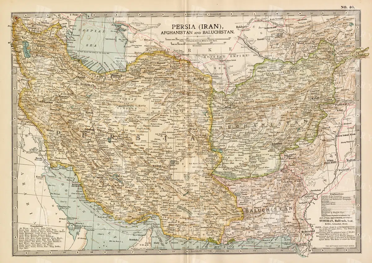
Antique Map of Persia, Afghanistan, and Baluchistan with Geopolitical Borders
This antique map of Persia (modern-day Iran), Afghanistan, and Baluchistan highlights the geopolitical borders and key cities of the early 20th century. The map details the region's topographical features, including mountain ranges, rivers, and deserts, offering a comprehensive view of the landscape. It provides a historical perspective on the political and geographical divisions in this part of the Middle East and South Asia during the period.
- Resolution: 7148 x 5100
- Image Type(s): JPG
- Afghanistan
- Afghanistan history
- Antique
- antique map
- Atlas
- Baluchistan
- cartography
- cities
- colonial
- country
- deserts
- early 20th century
- exploration
- Geography
- geopolitical borders
- historical geography
- historical map
- History
- Iran
- Landscape
- Map
- Middle East
- mountain ranges
- old map
- Persia
- Persia history
- representation
- Rivers
- South Asia
- topography
- World
From this collection

Antique 1800s Map of Arabia, Oman, and Aden Including the Arabian Peninsula – Vintage Historical Map
This antique map from the 1800s illustrates the Arabian Peninsula, including Arabia, Oman, and Aden. The vintage map highlights the region's historical geography, boundaries, and important cities, offering a detailed view of the area during the colonial period. A valuable resource for those interested in Middle Eastern history and cartography.
- Resolution: 7106 x 5100
- Image Type(s): JPG
From this collection
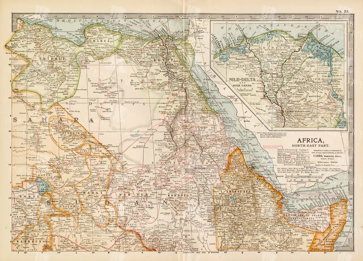
Vintage 1800s Map of North-East Africa Including Egypt, Sudan, and the Nile Delta – Antique Historical Map
This vintage map from the 1800s illustrates North-East Africa, including Egypt, Sudan, and the Nile Delta. The map is a beautiful representation of the region's historical geography, showing important cities, boundaries, and geographical features from the colonial era. A valuable piece for those interested in African history and cartography.
- Resolution: 7101 x 5100
- Image Type(s): JPG
- 1800s
- Africa
- Africa colonial
- Africa map
- Antique
- antique map
- Atlas
- boundaries
- cartography
- cities
- colonial era
- detailed
- Egypt
- exploration
- Geography
- historical
- historical geography
- historical map
- illustration
- Map
- Nile Delta
- North-East Africa
- old map
- preserved
- representation
- retro
- Rivers
- Sudan
- topography
- Travel
- vintage
- vintage map
- World
From this collection

Antique Map of Washington State
Antique map of Washington State, featuring towns, counties, railroads, and geographical features such as rivers and mountains. 19th century cartography highlighting the development and infrastructure of the state.
- Resolution: 7278 x 5100
- Image Type(s): JPG
- 19th-century
- American history
- Antique
- archival
- Atlas
- cartographer
- cartography
- classic
- collectible
- counties
- detailed map
- education
- exploration
- geographical features
- Geography
- heritage
- historical
- historical map
- historical washington
- History
- infrastructure
- Map
- Mountains
- northwest history
- nostalgic
- old map
- pacific northwest
- railroads
- reference
- representation
- Rivers
- state boundaries
- state development
- towns
- transportation
- USA
- vintage
- Washington
- washington geography
- washington map
- washington state
- World
From this collection

19th Century Map of Switzerland, Liechtenstein, and Parts of Austria-Hungary
A detailed antique map from the 19th century showcasing Switzerland, Liechtenstein, and parts of Austria-Hungary. The map highlights the mountainous terrain, lakes, and major cities, reflecting the historical borders and settlements of the region.
- Resolution: 7267 x 5100
- Image Type(s): JPG
From this collection
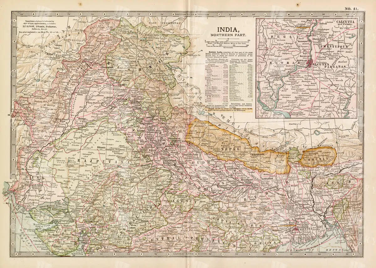
Historical Map of Northern India and Nepal Featuring Mountainous Terrain
Historical Map of Northern India and Nepal Featuring Mountainous Terrain
- Resolution: 7144 x 5100
- Image Type(s): JPG
- Antique
- antique map
- Atlas
- cartography
- cities
- colonial
- early 20th century
- exploration
- Geography
- Globe
- Himalayas
- historical
- historical geography
- historical map
- History
- Landscape
- Map
- mountainous terrain
- Navigation
- Nepal
- Northern India
- old
- old map
- political boundaries
- representation
- Rivers
- South Asia
- South Asian history
- topography
- transportation
- World
From this collection

Antique 1800s Map of Arkansas with Detailed County Lines and Natural Features – Vintage Historical Cartography
An antique map from the 1800s showcasing Arkansas, with detailed county lines and natural features. This vintage map provides a historical view of Arkansas’s geography during the 19th century, offering a beautifully preserved piece of the state’s cartographic history.
- Resolution: 7108 x 5100
- Image Type(s): JPG
From this collection

Vintage Map of Northern Illinois Featuring Chicago and Surrounding Areas
This vintage map of Northern Illinois features Chicago and its surrounding areas, highlighting major transportation routes, rivers, and urban centers. The map provides a detailed overview of the region's geography during the early 20th century, showcasing the development and expansion of Chicago as a key American city. It offers a historical perspective on the infrastructure and urban planning of the time.
- Resolution: 7142 x 5100
- Image Type(s): JPG
From this collection

Historical Map of Idaho and Wyoming Including Yellowstone National Park
This historical map covers the states of Idaho and Wyoming, with a special focus on Yellowstone National Park. The map details the topographical features, including mountains, rivers, and forests, as well as the transportation routes and political boundaries of the early 20th century. It provides a valuable snapshot of the American West during this period, highlighting the natural beauty and geographical diversity of the region.
- Resolution: 7141 x 5100
- Image Type(s): JPG
- American West
- Antique
- antique map
- cartography
- conservation
- early 20th century
- exploration
- forests
- Geography
- historical
- historical geography
- historical map
- History
- Idaho
- Landscape
- Map
- Mountains
- national parks
- old
- old map
- political boundaries
- representation
- Rivers
- topography
- transportation
- United States
- vintage
- Western states
- Wyoming
- Yellowstone National Park
From this collection

Detailed 19th Century Map of Illinois, USA
A richly detailed 19th century map of Illinois, focusing on the southern part of the state, including the area around Chicago and St. Louis. The map is intricately detailed with towns, railways, and geographical features, showcasing the state’s development during the period.
- Resolution: 7265 x 5100
- Image Type(s): JPG
- 19th-century
- America
- Antique
- antique map
- archives
- Atlas
- Borders
- cartography
- Chicago
- counties
- country
- development
- Engineering
- exploration
- Geography
- heritage
- historic
- historical
- History
- Illinois
- landmarks
- Map
- Midwest
- old map
- railways
- reference
- representation
- retro
- Rivers
- Rural
- settlements
- southern Illinois
- St. Louis
- territorial
- topographic
- topography
- towns
- transportation
- urban
- USA
- vintage
- World
From this collection

Diving Bell Line Art Illustration Industrial Isolated PNG
A vintage isolated line art illustration of a diving bell, showcasing its industrial design for underwater exploration, suitable for maritime-themed projects.
- Image Type(s): PNG
Related Images

Diving Bell Line Art Illustration Industrial Artwork
A vintage line art illustration of a diving bell, depicting the industrial design used in historical underwater exploration. Perfect for educational and maritime themes.
- Image Type(s): PNG
Related Images

Vintage 1800s Map of Arizona and New Mexico Showing Territorial Boundaries and Natural Features – Antique Map
This vintage map from the 1800s depicts Arizona and New Mexico, highlighting territorial boundaries and natural features. The antique map offers a historical view of the region's geography during a formative period in its history, with intricate details of the landscape and settlements. Ideal for history buffs and map collectors.
- Resolution: 7107 x 5100
- Image Type(s): JPG
- 1800s
- American history
- American West
- Antique
- antique map
- Arizona
- Arizona map
- cartography
- colonial era
- detailed
- exploration
- Geography
- historical
- historical map
- journal
- Map
- natural features
- New Mexico
- New Mexico map
- old map
- political map
- preserved
- regional history
- representation
- retro
- territorial boundaries
- topography
- vintage
- vintage map
From this collection

Antique Map of Southern India and the Straits Settlements with Ceylon
This antique map depicts Southern India and the Straits Settlements, including the island of Ceylon (now Sri Lanka). The map highlights key cities, transportation networks, and topographical features such as rivers and mountain ranges. It provides a historical perspective on the colonial boundaries and geopolitical landscape of the region during the early 20th century, reflecting the connection between Southern India and Southeast Asia.
- Resolution: 7145 x 5100
- Image Type(s): JPG
- Antique
- antique map
- Atlas
- British Empire
- cartography
- Ceylon
- cities
- colonial boundaries
- country
- early 20th century
- exploration
- Geography
- Globe
- historical geography
- historical map
- History
- Indian Ocean
- Landscape
- Map
- mountain ranges
- old map
- representation
- Rivers
- South Asia
- Southeast Asia
- Southern India
- Sri Lanka
- Straits Settlements
- transportation
- Travel
- World
From this collection

Vintage Map of Indiana Highlighting Transportation Networks and County Borders
This vintage map of Indiana highlights the state's transportation networks, including roads and railroads, along with its county borders. The map provides a detailed view of Indiana's geography during the early 20th century, focusing on the development of infrastructure and urban areas. It offers a historical overview of the state's growth and the connections between its cities and rural areas.
- Resolution: 7146 x 5100
- Image Type(s): JPG
From this collection

Detailed Antique Map of Iowa with County Boundaries and Transportation Routes
This detailed antique map of Iowa showcases the state's county boundaries, major cities, and transportation routes, including roads and railroads. The map provides a comprehensive view of Iowa's geography during the early 20th century, highlighting the state's agricultural landscape and infrastructure development. It serves as a valuable resource for understanding Iowa's historical growth and its place in the broader Midwest.
- Resolution: 7147 x 5100
- Image Type(s): JPG
From this collection

Antique 1800s Map of Central Africa Featuring Colonial Territories and Natural Features – Vintage Historical Map
This detailed antique map from the 1800s depicts Central Africa, highlighting various colonial territories, natural features, and historical locations. It showcases the intricate geography of the region during the colonial period, offering a glimpse into the past through this vintage, beautifully preserved map.
- Resolution: 7100 x 5100
- Image Type(s): JPG
- 1800s
- Africa
- Africa colonial
- Africa map
- Antique
- antique illustration
- Atlas
- Borders
- cartography
- Central Africa
- colonial
- colonialism
- detailed
- exploration
- Geography
- historical
- historical map
- History
- illustration
- Map
- Mountains
- natural features
- old map
- past
- preserved
- regions
- representation
- retro
- Rivers
- territories
- topography
- vintage
- vintage map
- World
From this collection

Support the Library
Our supporters and members help us continue collecting and restoring these wonderful pieces of art for the modern creator
Unlock Everything and Become a Member!
While a lot of the library is available for free, some is kept behind closed dusty doors only to be accessed by our lovely members.