

Globe and Clouds Vector Lineart Illustrations – Vintage World and Cloud Clip Art – PNG, SVG, and EPS Vector Formats Included!
You're looking at a unique set of globe and cloud illustrations discovered in a late 1800s design book. These illustrations were extracted from their original backgrounds and converted to the following image formats: SVG (vector), EPS (vector), and, of course, PNG (300dpi raster image with transparent background).
- Image Type(s): EPS, SVG, PNG
Related Images


Vintage Heraldry Vector Illustration Collection Featuring Hands, Shield, Eagle, Trumpet, Foliage, and Globe
A meticulously crafted vector sheet showcasing a vintage collection of heraldry illustrations. This design features symbolic elements like hands grasping a sickle, shield, trumpet, and a globe, alongside an eagle, grapevine, and various ornate foliage. Rendered in a classic engraving style, each element embodies historical and cultural significance in heraldic art. Ideal for vintage-themed design projects, historical presentations, and decorative art pieces, this collection captures the essence of traditional armory symbols and emblems.
- Image Type(s): EPS, SVG, PNG
- armory
- Artwork
- Black and white
- classic
- Coat of Arms
- cultural
- Decorative
- Design
- detailed
- Eagle
- Emblem
- Engraving
- engraving style
- Foliage
- Globe
- grapevine
- Hands
- heraldic elements
- Heraldry
- historical
- historical art
- illustration
- Insignia
- medieval
- Ornate
- ornate design
- Shield
- sickle
- symbolic elements
- symbolic imagery
- traditional
- traditional design
- traditional symbols
- Trumpet
- vector
- vector art
- vintage
- vintage collection
From this collection

WORLD MAP – Rare Antique Print – J. Robins & Co. Albion Press London 1800s
You're looking at an Original pre-1820's Antique Engraving from a rare copy of Abraham Rees' "The Cyclopaedia; or, UNIVERSAL DICTIONARY OF ARTS, SCIENCES, and LITERATURE" (Published 1820 by Longman, Hurst, Rees, Orme)
- License Info
- Resolution: 15400 x 9200 300dpi
- Year of Print: 1800s
- Artist: Abraham Rees
From this collection

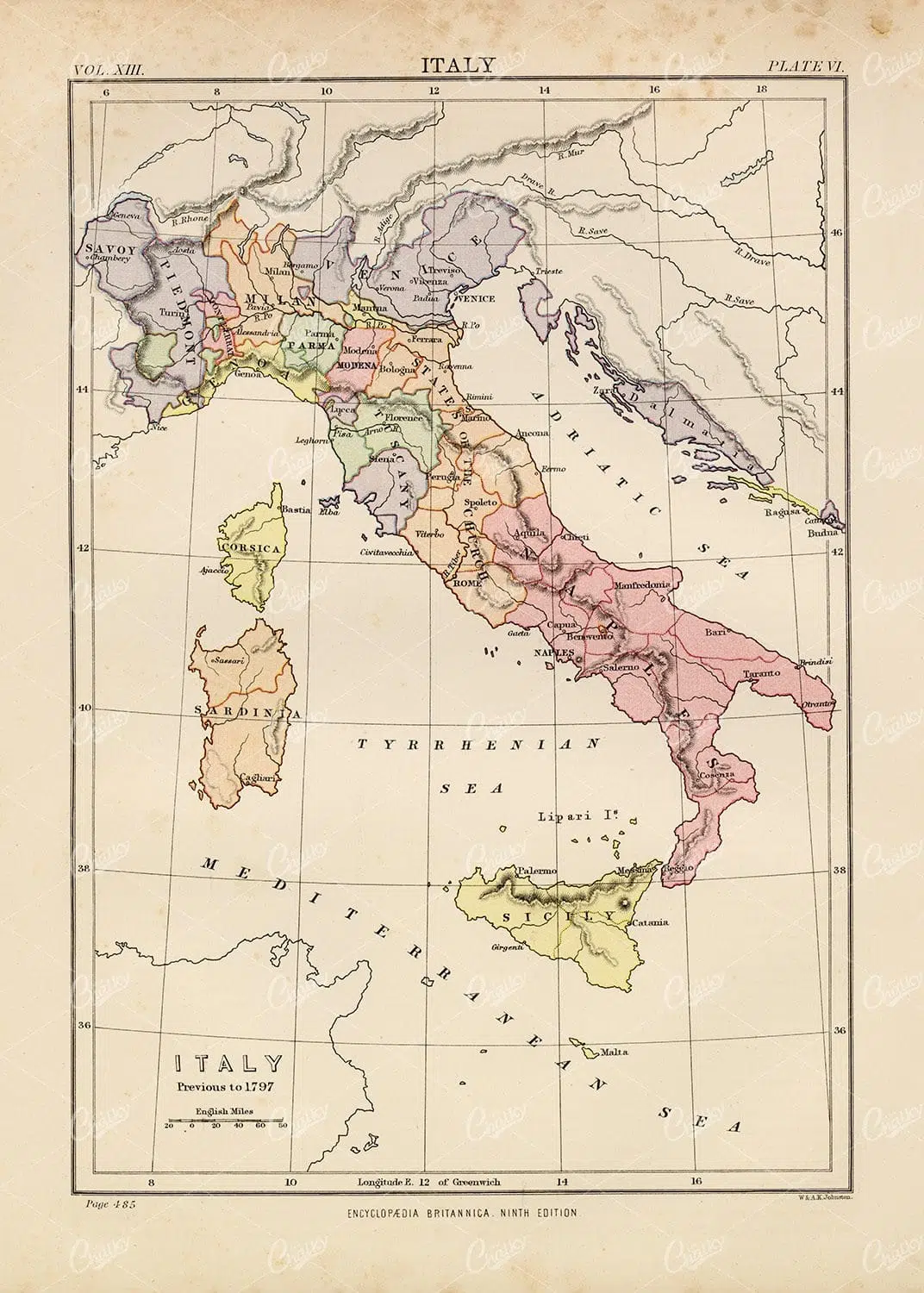
Vintage Map of Italy – Encyclopedia Britannica 1880
- License Info
- Resolution: 6938px x 9452px
- Year of Print: 1880
- Artist: Encyclopedia Britannica
From this collection

1880 Encyclopedia Britannica Vintage Botany Print
- License Info
- Resolution: 6841px x 9579px
- Year of Print: 1880
- Artist: Encyclopedia Britannica
From this collection

2 Botanical Butterfly Coaster Designs with Vintage Handwriting
These two round designs feature pretty butterflies, leafy plants, and a hint of antique handwriting for a charming, vintage-inspired look. They’re perfect for DIY coasters, scrapbook embellishments, or any creative project that could use a soft, nature-themed accent. If you love blending old-school style with a modern twist, these designs are a great pick.
- Resolution: 2057 x 2057
- Image Type(s): .ZIP (Pngs)
From this collection

Vintage Map of Italy – Encyclopedia Britannica 1880
- License Info
- Resolution: 7324px x 9646px
- Year of Print: 1880
- Artist: Encyclopedia Britannica
From this collection
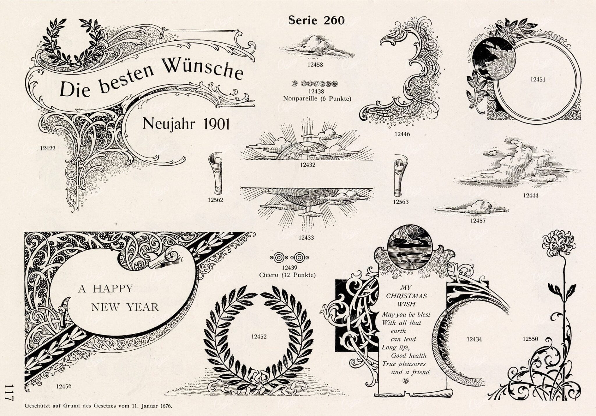
VINTAGE Decorative Design Elements – Ornamental Banners For Type
The type foundry and print shop of old would create books, like the one this image was discovered within, to help customers and clients with their design choices. Naturally, these books were jam packed with useful illustrative elements that could be combined to create a final piece. Today, these books are extremely difficult to get a hold of. Especially those that were published in the late 1800s. They were not mainstream publications, they simply served as 'catalogs' and thus were only produced in small numbers. Fortunately, we were introduced to a collector who had precisely what we had been searching for for so long. After some costly negotiations, we're very excited to be able to share the wonderful gems within.
- License Info
- Resolution: 7494 x 5383
- Year of Print: Late 1800s
- Artist: Schelter & Giesecke Type Foundry
From this collection
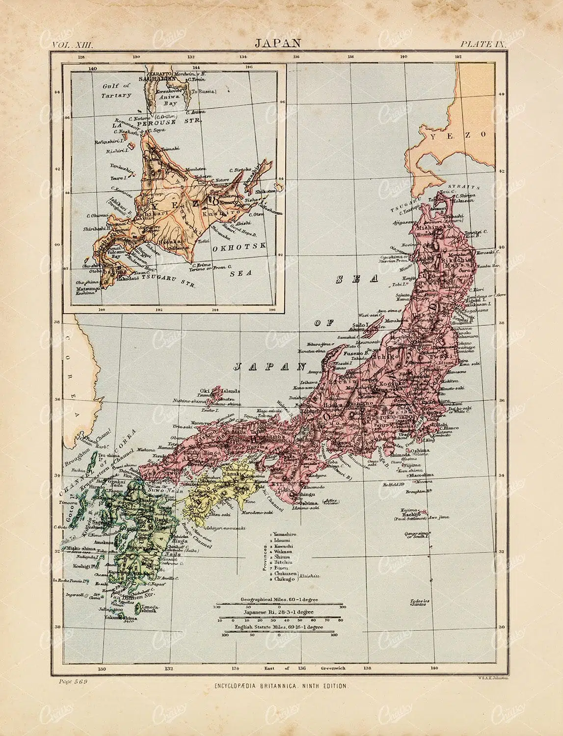
Antique Map of Japan – 1880 Encyclopedia Britannica
- License Info
- Resolution: 7359px x 9623px
- Year of Print: 1880
- Artist: Encyclopedia Britannica
From this collection

WORLD MAP Physical Map of Mountain-Chains and River Systems. 1880 Stock Image
An original Antique Plate scan from the National Encyclopaedia: A Dictionary of Universal Knowledge. Published by William Mackenzie in 1880. Click on the Artist's name to see the full collection from this series!
- License Info
- Resolution: 7594 x 10009 300dpi
- Year of Print: 1880
- Artist: William Mackenzie
From this collection
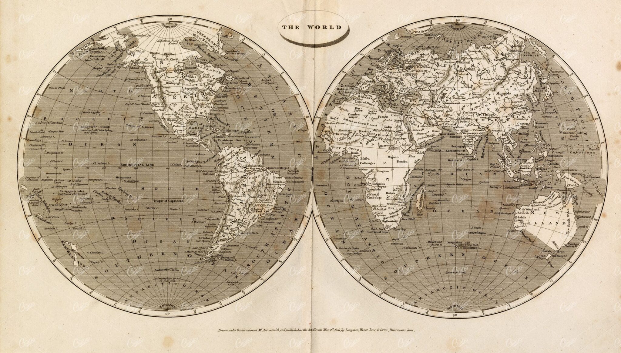
ANTIQUE Map of The World – Rees’ Encyclopedia 1800s
- License Info
- Resolution: 14829px x 8428px
- Year of Print: 1800s
- Artist: Abraham Rees
From this collection
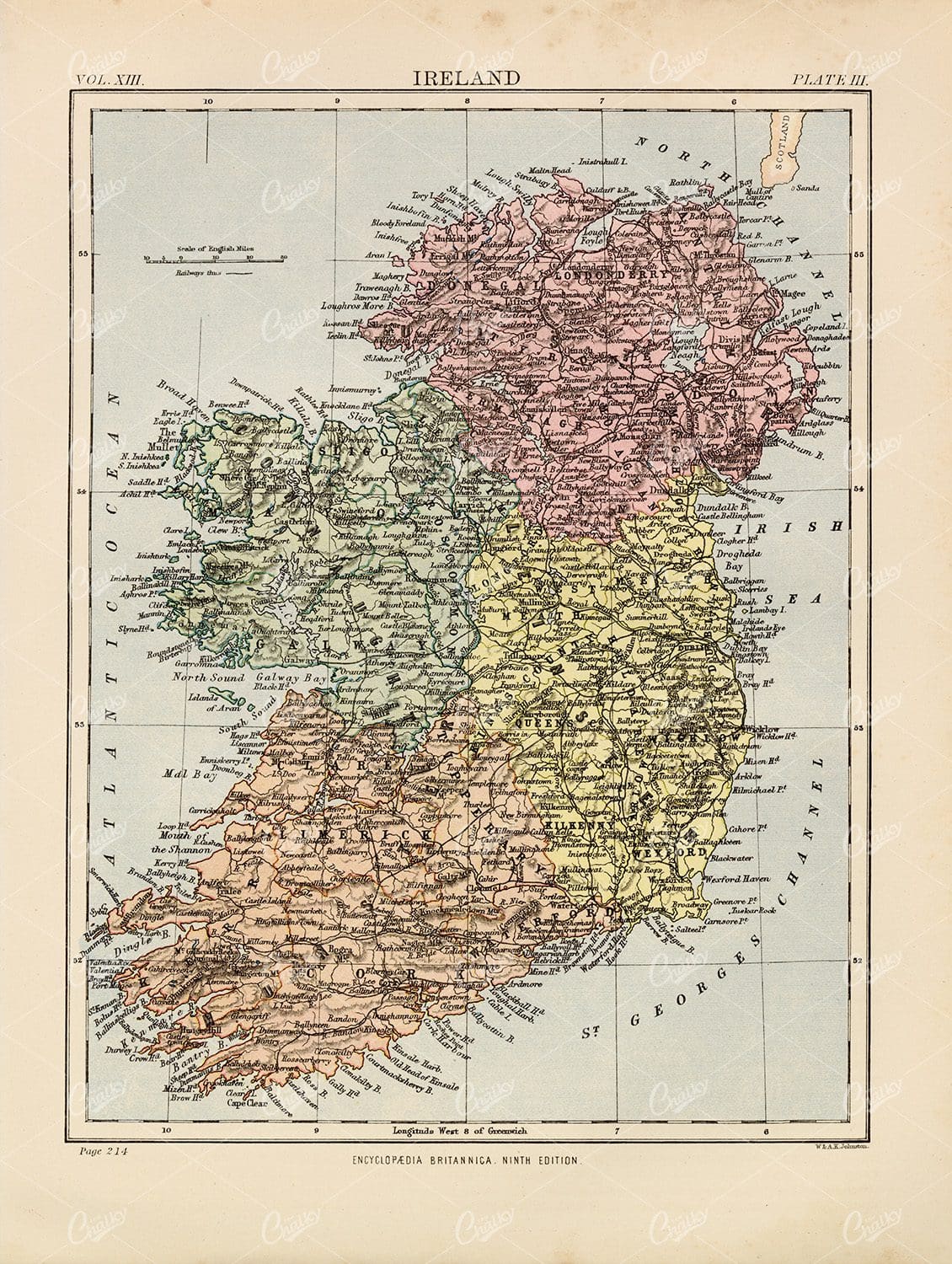
Encyclopedia Britannica 1880 – Vintage Map of Ireland
- License Info
- Resolution: 7244px x 9615px
- Year of Print: 1880
- Artist: Encyclopedia Britannica
From this collection
Vintage Map of Italy – Encyclopedia Britannica 1880
- License Info
- Resolution: 6890px x 9639px
- Year of Print: 1880
- Artist: Encyclopedia Britannica
From this collection

Antique 1880 Print – Vintage Map of Mexico
- License Info
- Resolution: 13544px x 9426px
- Year of Print: 1880
- Artist: Encyclopedia Britannica
From this collection
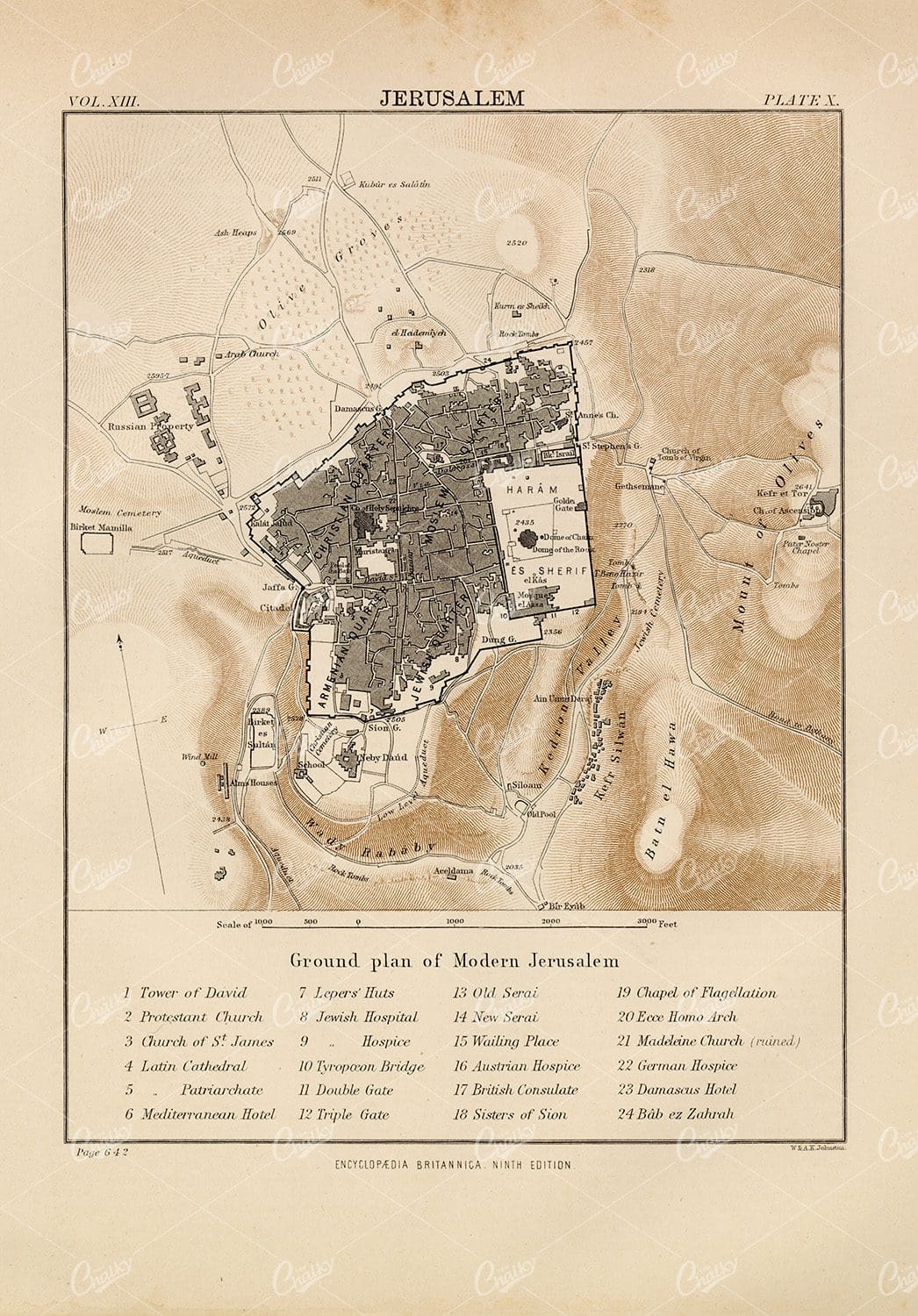
Ground Plan of Modern Jerusalem – 1880 Vintage Print
- License Info
- Resolution: 6675px x 9574px
- Year of Print: 1880
- Artist: Encyclopedia Britannica
From this collection
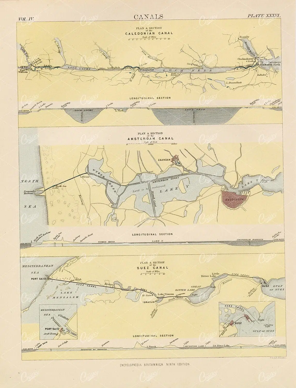
Vintage Print of Various Canals – 1880 Encyclopedia Britannica
- License Info
- Resolution: 7302px x 9558px
- Year of Print: 1880
- Artist: Encyclopedia Britannica
From this collection
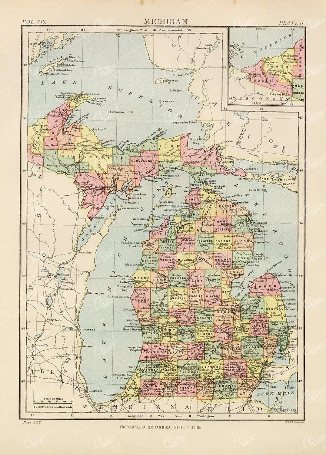
1880 Vintage Map of Michigan – Encyclopedia Britannica
- License Info
- Resolution: 6864px x 9573px
- Year of Print: 1880
- Artist: Encyclopedia Britannica
From this collection
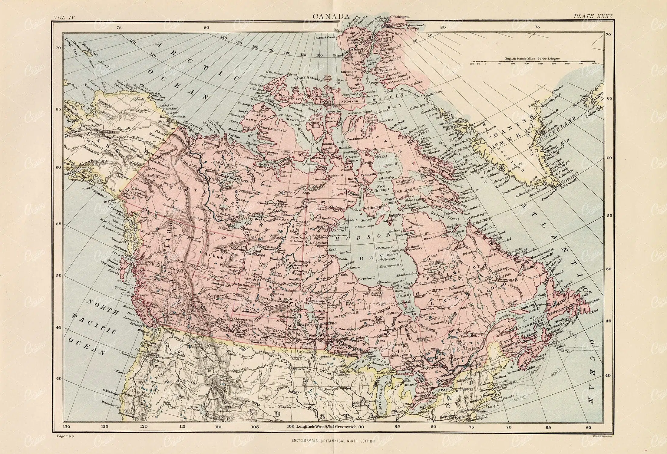
Vintage Map of Canada – 1880 Encyclopedia Britannica
- License Info
- Resolution: 13853px x 9433px
- Year of Print: 1880
- Artist: Encyclopedia Britannica
From this collection

Antique Map of Brazil – 1880 Encyclopedia Britannica
- License Info
- Resolution: 7007px x 9539px
- Year of Print: 1880
- Artist: Encyclopedia Britannica
From this collection

ORIGINAL Old Antique Print – Plate Heraldry Crests c1900s Globes Birds
- License Info
- Resolution: 7644 x 10338 300dpi
- Year of Print: 1900
- Artist: Knight & Rumley
From this collection
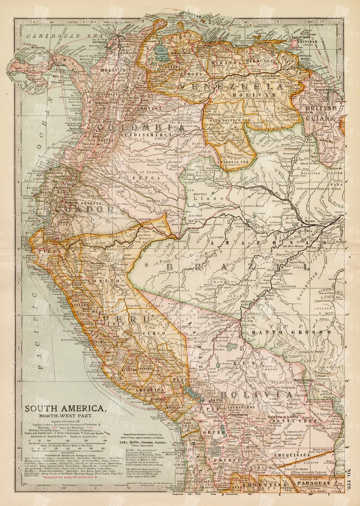
Detailed 19th Century Map of Northwestern South America
A detailed 19th century map illustrating the northwestern part of South America, including countries like Colombia, Venezuela, and Ecuador. This vintage map offers a glimpse into the political and geographical divisions of the era, with detailed insets of major cities and regions.
- Resolution: 7260 x 5100
- Image Type(s): JPG
- 1800s
- 19th-century
- Antique
- antique cartography
- antique map
- antique paper
- archival
- Atlas
- cartographic history
- cartography
- cities
- Colombia
- country
- Ecuador
- geographical features
- Geography
- Globe
- heritage
- historical artifact
- historical document
- historical geography
- historical information
- historical map
- historical records
- history lovers
- Latin America
- Map
- map of Colombia
- Navigation
- Northwestern South America
- old map
- old South America
- political divisions
- representation
- South America
- South American history
- topography
- Travel
- Venezuela
- vintage
- vintage map
- World
From this collection
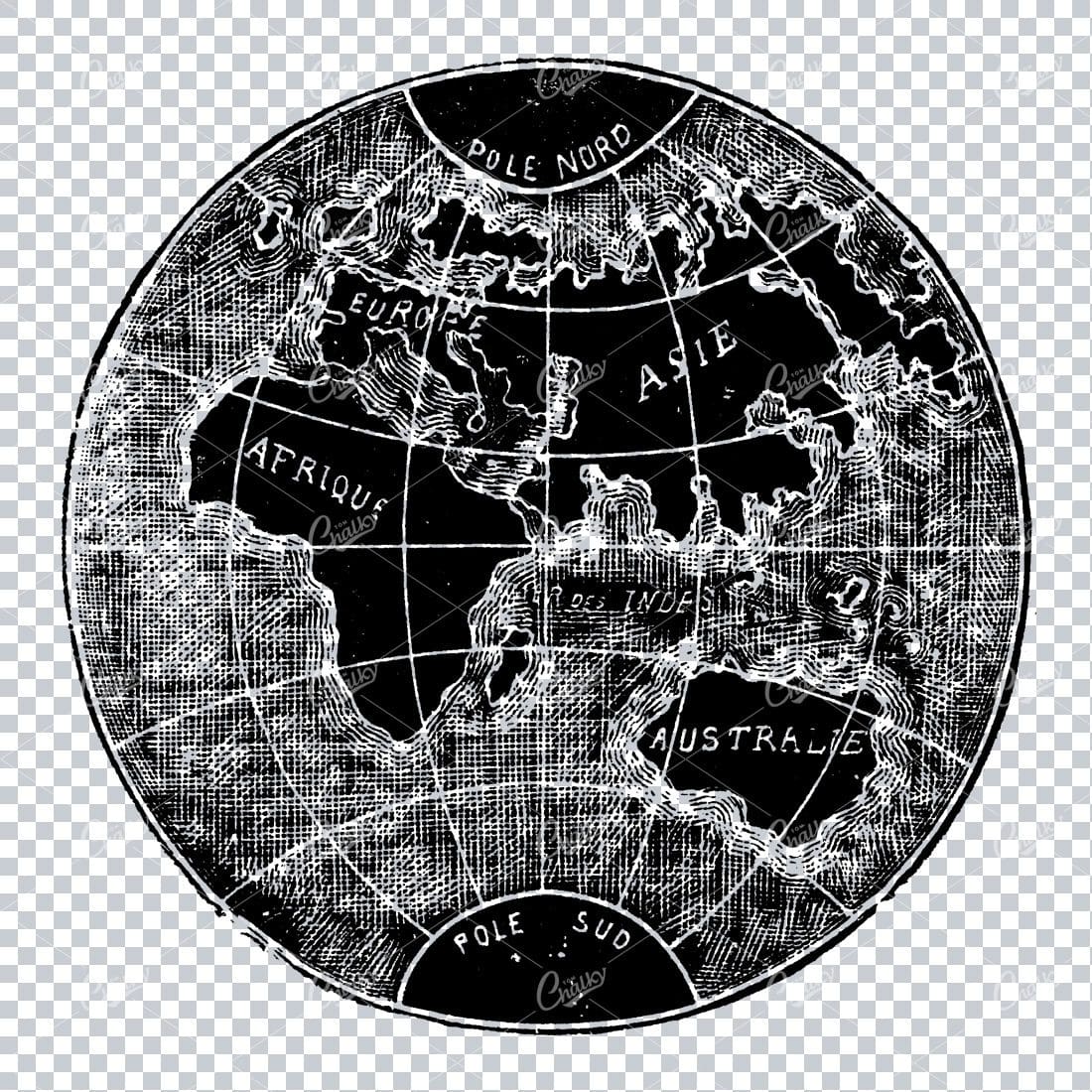
Small Vintage Illustration of the World / Globe Map
- License Info
- Resolution: 1805px x 1780px
Related Images


1880 Encyclopedia Britannica – Antique Map of Mississippi
- License Info
- Resolution: 7008px x 9584px
- Year of Print: 1880
- Artist: Encyclopedia Britannica
From this collection

New Guinea and New Caledonia Vintage Map 1880
- License Info
- Resolution: 9489px x 7333px
- Year of Print: 1880
- Artist: Encyclopedia Britannica
From this collection

Central Europe Travel Map Featuring Major Cities Like Paris, Berlin, and Vienna
This travel map of Central Europe highlights major cities such as Paris, Berlin, and Vienna, showcasing detailed routes and geographical features. The map provides a glimpse into the historical and political landscape of Central Europe during the time.
- Resolution: 7117 x 5100
- Image Type(s): JPG
From this collection
Encyclopedia Britannica 1880 – New Jersey Vintage Map
- License Info
- Resolution: 6996px x 9597px
- Year of Print: 1880
- Artist: Encyclopedia Britannica
From this collection

Antique Map of the Mohammedan Empire – 1880
- License Info
- Resolution: 9499px x 7247px
- Year of Print: 1880
- Artist: Encyclopedia Britannica
From this collection

Vintage 1880 Print – Map of Minnesota
- License Info
- Resolution: 6920px x 9572px
- Year of Print: 1880
- Artist: Encyclopedia Britannica
From this collection
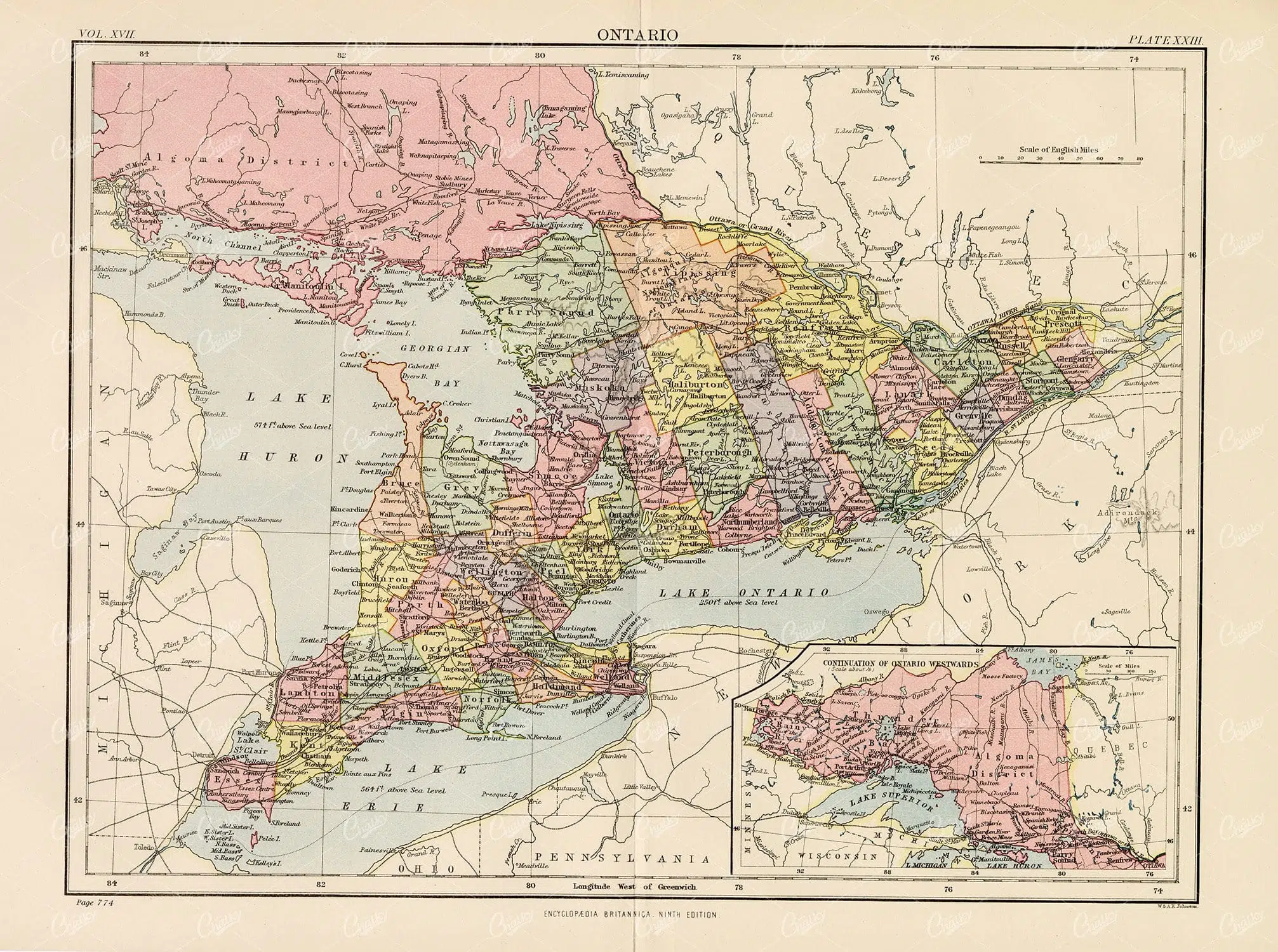
Encyclopedia Britannica 1880 – Vintage Map of Ontario
- License Info
- Resolution: 12700px x 9463px
- Year of Print: 1880
- Artist: Encyclopedia Britannica
From this collection
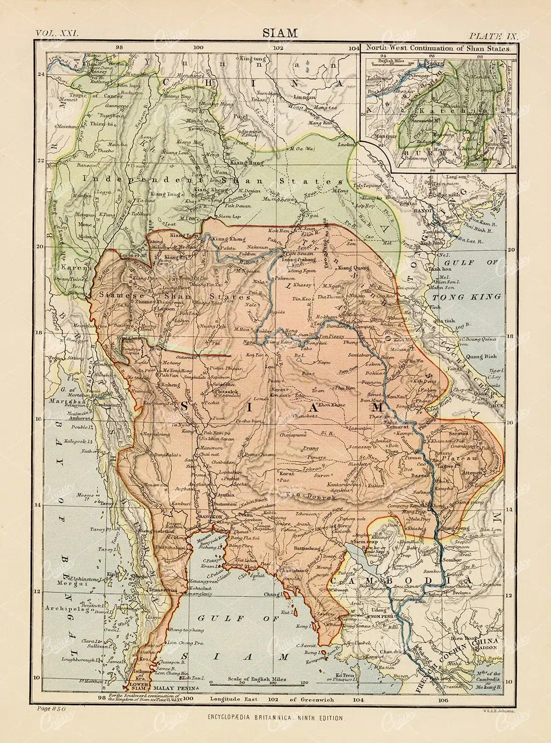
Antique Map of Siam – 1880 Encyclopedia Britannica
- License Info
- Resolution: 7016px x 9455px
- Year of Print: 1880
- Artist: Encyclopedia Britannica
From this collection

1880 Vintage Print – Antique Map of Oregon & Washington
- License Info
- Resolution: 7207px x 9581px
- Year of Print: 1880
- Artist: Encyclopedia Britannica
From this collection
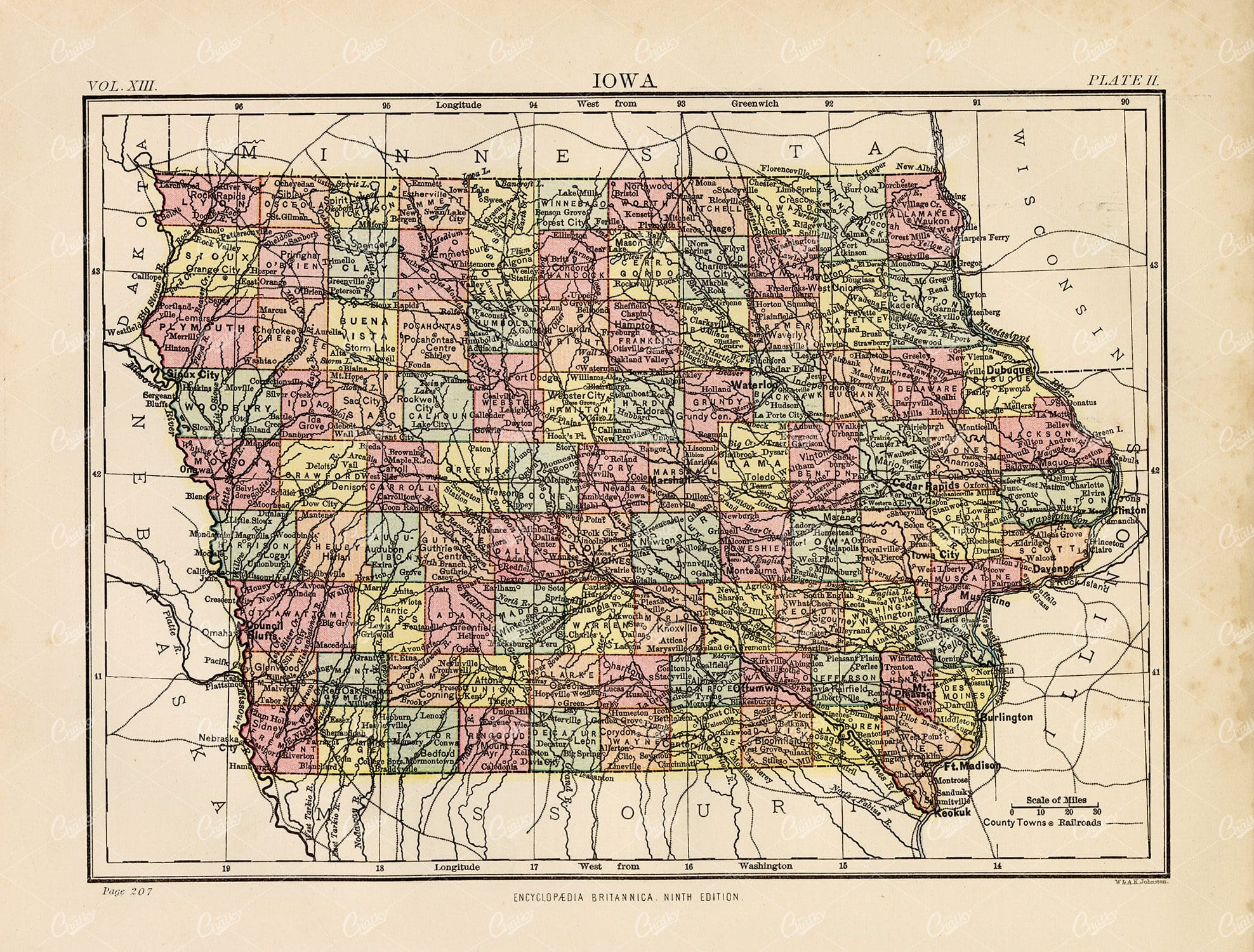
Vintage Print 1880 – Antique Map of Iowa
- License Info
- Resolution: 9570px x 7265px
- Year of Print: 1880
- Artist: Encyclopedia Britannica
From this collection
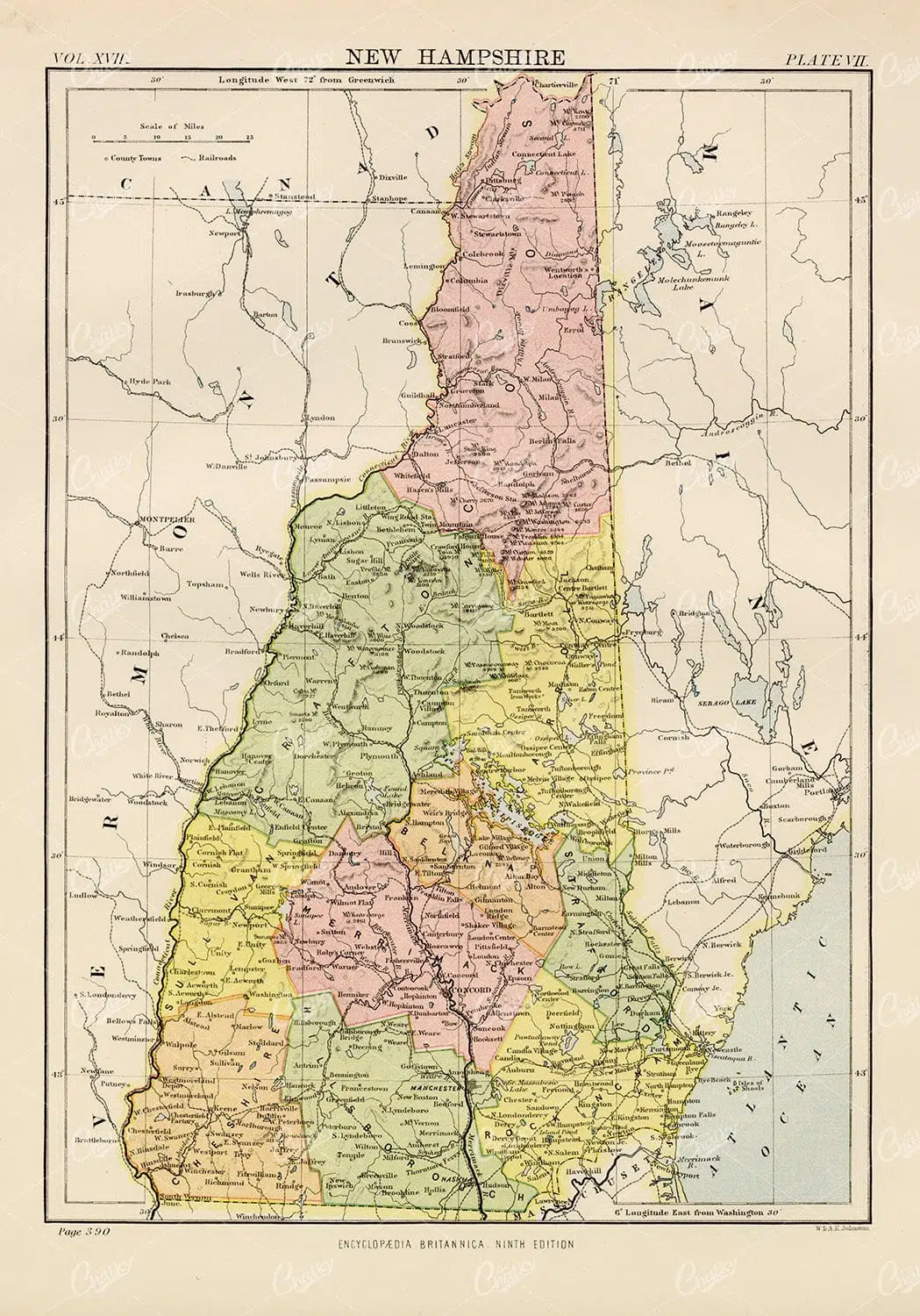
Encyclopedia Britannica 1880 – Vintage Map of New Hampshire
- License Info
- Resolution: 6693px x 9568px
- Year of Print: 1880
- Artist: Encyclopedia Britannica
From this collection

Vintage Map of Nebraska – Encyclopedia Britannica 1880
- License Info
- Resolution: 9549px x 7362px
- Year of Print: 1880
- Artist: Encyclopedia Britannica
From this collection

VINTAGE Print of a Star Map of the Southern Sky – Antique 1882
- License Info
- Resolution: 8207px x 8732px
- Year of Print: 1882
Related Images

Antique Map of Missouri – Encyclopedia Britannica 1880
- License Info
- Resolution: 9571px x 7359px
- Year of Print: 1880
- Artist: Encyclopedia Britannica
From this collection
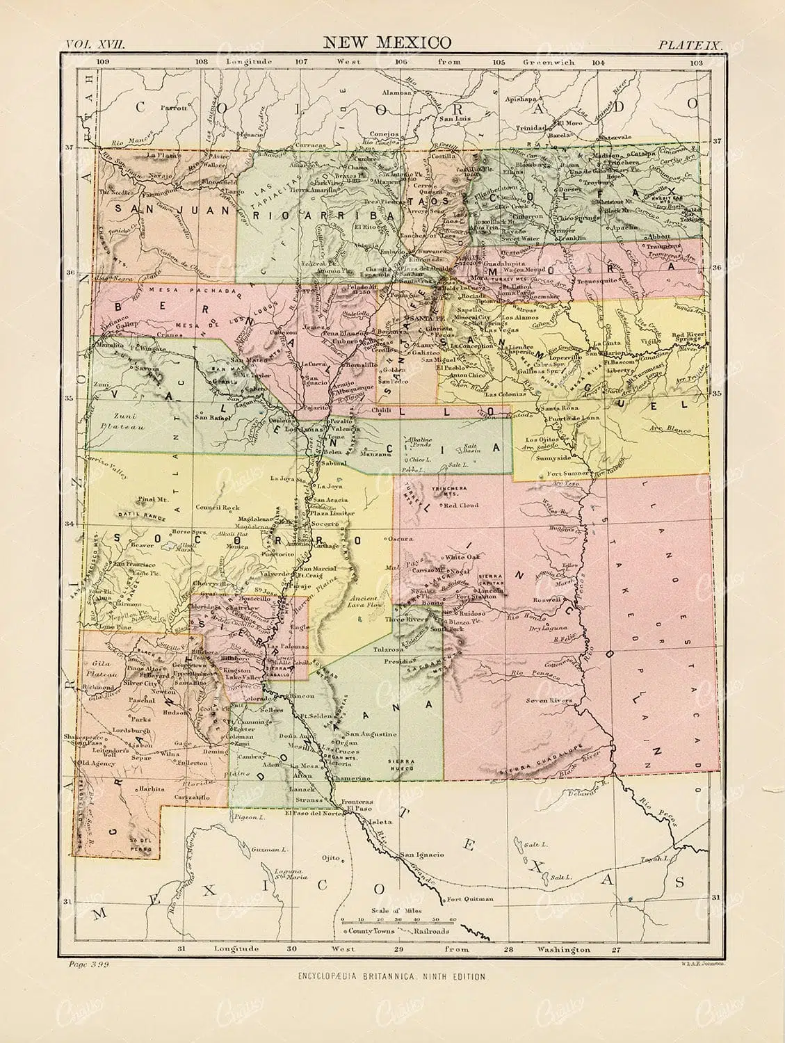
New Mexico Vintage Map – Encyclopedia Britannica 1880
- License Info
- Resolution: 7202px x 9565px
- Year of Print: 1880
- Artist: Encyclopedia Britannica
From this collection

Vintage Map of Nevada – 1880 Encyclopedia Britannica
- License Info
- Resolution: 7034px x 9557px
- Year of Print: 1880
- Artist: Encyclopedia Britannica
From this collection

Jamaica and Java Antique Map – vintage Print 1880
- License Info
- Resolution: 9519px x 7222px
- Year of Print: 1880
- Artist: Encyclopedia Britannica
From this collection
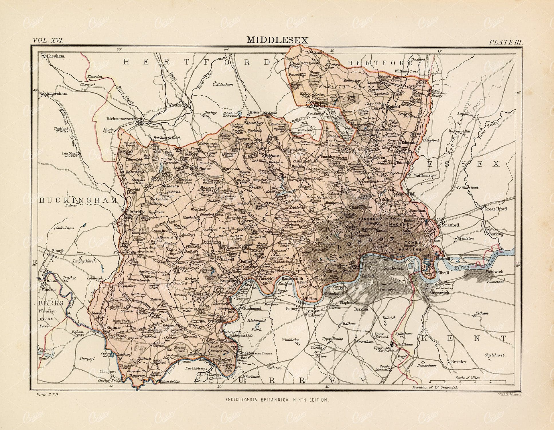
1880 Vintage Map of Middlesex – Encyclopedia Britannica
- License Info
- Resolution: 9385px x 7277px
- Year of Print: 1880
- Artist: Encyclopedia Britannica
From this collection

Vintage Map of Southern England Including London, Brighton, and Major Coastal Cities
A vintage map of Southern England, highlighting major cities like London and Brighton, as well as coastal areas. The map provides detailed insights into the region's historical geography, transportation routes, and urban development.
- Resolution: 7129 x 5100
- Image Type(s): JPG
From this collection

Antique 1800s Map of North-West Africa Highlighting Morocco, Algeria, and Western Sahara – Vintage Historical Map
This antique map from the 1800s highlights North-West Africa, including Morocco, Algeria, and the Western Sahara. It captures the colonial and geographical landscape of the time, showing intricate details of the region’s political boundaries and natural features. A beautifully preserved piece of history in vintage cartography.
- Resolution: 7102 x 5100
- Image Type(s): JPG
- 1800s
- Africa
- Africa colonial
- Africa map
- Algeria
- Antique
- antique map
- Atlas
- cartography
- colonial
- colonial era
- country
- detailed
- exploration
- Geography
- Globe
- historical
- historical map
- History
- Map
- Morocco
- natural features
- Navigation
- North-West Africa
- old
- old map
- political boundaries
- preserved
- representation
- retro
- topography
- Travel
- vintage
- vintage map
- Western Sahara
- World
From this collection
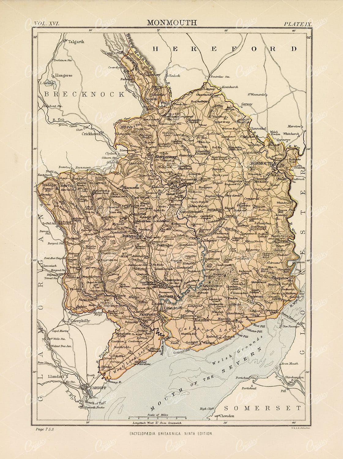
Vintage Map of Monmouth – Encyclopedia Britannica 1880
- License Info
- Resolution: 7145px x 9563px
- Year of Print: 1880
- Artist: Encyclopedia Britannica
From this collection
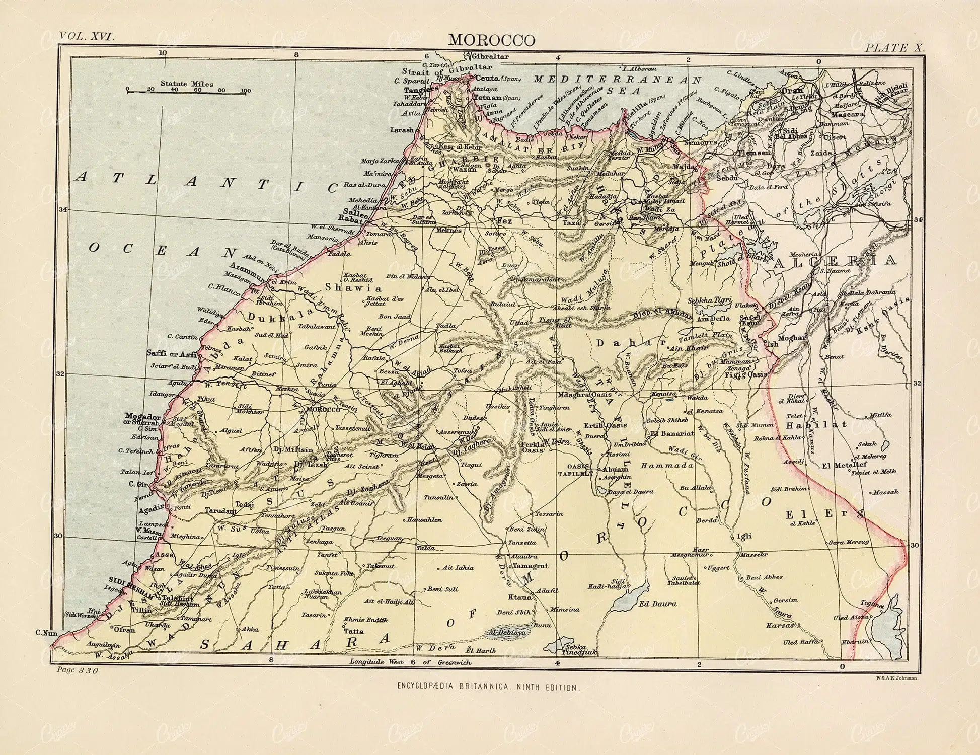
Vintage Map of Morocco – Encyclopedia Britannica 1880
- License Info
- Resolution: 9394px x 7239px
- Year of Print: 1880
- Artist: Encyclopedia Britannica
From this collection

Antique Map of West Virginia
Detailed antique map of West Virginia, showing counties, towns, railroads, and geographical features. Historical 19th century cartography with insets of surrounding areas. An educational and collectible piece.
- Resolution: 7280 x 5100
- Image Type(s): JPG
- 19th-century
- American history
- Antique
- archival
- Atlas
- cartographer
- cartography
- classic
- collectible
- counties
- detailed map
- education
- exploration
- geographical features
- Geography
- Globe
- heritage
- heritage map
- historical
- historical map
- historical regions
- History
- Map
- nostalgic
- old
- old map
- railroads
- reference
- representation
- state boundaries
- state map
- surrounding areas
- topography
- towns
- transportation
- USA
- vintage
- vintage west virginia
- West Virginia
- west virginia counties
- west virginia map
- World
From this collection

Antique Map of Northern Ohio with Detailed City and County Lines
A historic map from the late 19th century detailing Northern Ohio, including major cities, counties, and transportation routes. This antique map highlights the region's development and infrastructure.
- Resolution: 7247 x 5100
- Image Type(s): JPG
From this collection

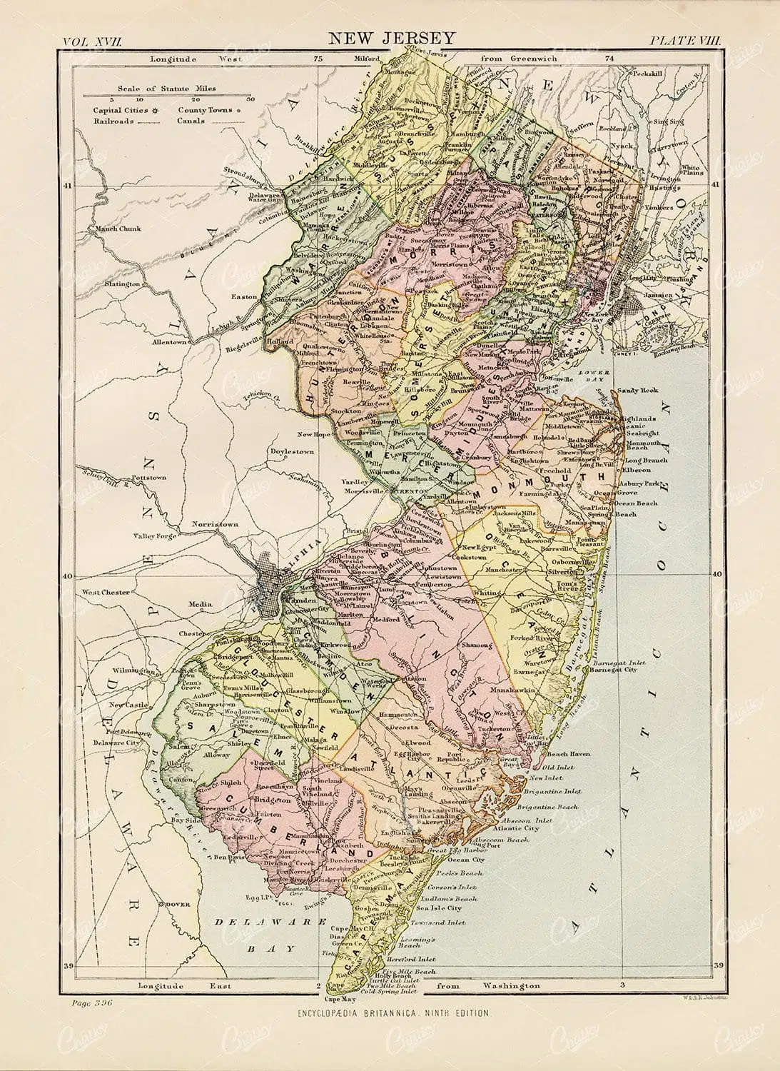
Historic Map of New Jersey
A detailed antique map of New Jersey, highlighting its counties, cities, and significant landmarks, reflecting the state's geography and development during the late 19th century.
- Resolution: 7239 x 5100
- Image Type(s): JPG
From this collection

Antique Map of New Brunswick, Nova Scotia, and Prince Edward Island
A historic map from the late 19th century illustrating the Canadian provinces of New Brunswick, Nova Scotia, and Prince Edward Island, featuring key cities, towns, and geographical landmarks.
- Resolution: 7238 x 5100
- Image Type(s): JPG
- 19th-century
- Antique
- Atlantic
- Atlas
- Borders
- Canada
- cartography
- cities
- classic
- coastline
- colonial
- country
- Geography
- Globe
- heritage
- History
- illustration
- Landscape
- Map
- maritime
- new brunswick
- novascotia
- Ocean
- princeed ward island
- provinces
- regions
- representation
- Rivers
- Road
- settlements
- territory
- topography
- tourism
- towns
- Travel
- vintage
- World
From this collection

Historical Map of Manitoba, British Columbia, and the Northwest Territories
A detailed historical map depicting the regions of Manitoba, British Columbia, and the Northwest Territories, showcasing topographical features, settlements, and boundaries in the early 20th century.
- Resolution: 7160 x 5100
- Image Type(s): JPG
- 20th
- Antique
- Atlas
- Borders
- boundaries
- British
- Canada
- cartography
- century
- climate
- coastline
- colonial
- columbia
- demographics
- division
- early
- exploration
- Geography
- Globe
- historical
- History
- infrastructure
- Landscape
- manitoba
- Map
- natural
- northwest
- provincial
- regions
- representation
- resources
- River
- settlement
- settlements
- territories
- topographical
- transportation
- Travel
- vintage
- World
From this collection

1897 Map of Italy: Northern Regions
This 1897 map offers a comprehensive view of Northern Italy, detailing its cities, mountain ranges, and infrastructure. The map covers important regions such as Piedmont, Lombardy, and Veneto, highlighting the area's rich history and development during the 19th century. It serves as a valuable historical document for understanding Italy's northern landscape at the time.
- Resolution: 7152 x 5100
- Image Type(s): JPG
From this collection

Support the Library
Our supporters and members help us continue collecting and restoring these wonderful pieces of art for the modern creator
Unlock Everything and Become a Member!
While a lot of the library is available for free, some is kept behind closed dusty doors only to be accessed by our lovely members.