
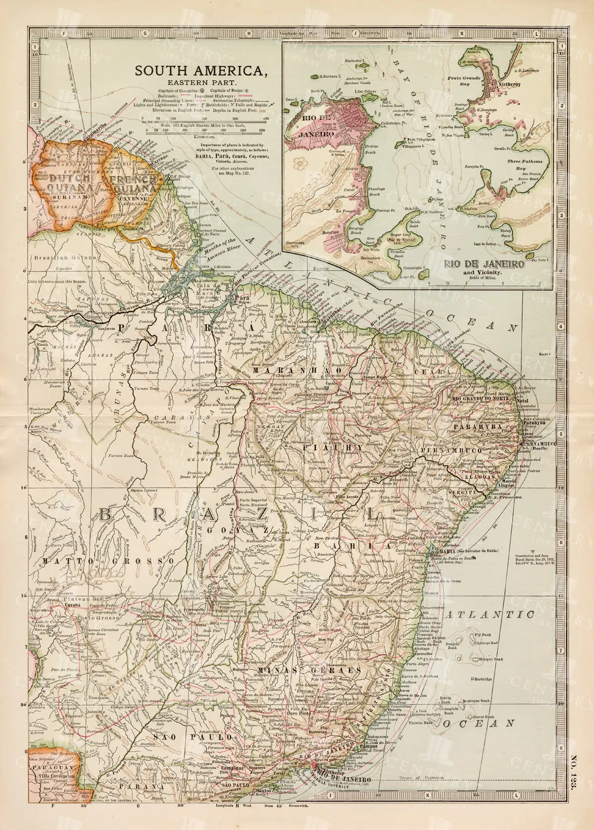
19th Century Map of Eastern South America Including Rio de Janeiro
A detailed 19th century map of Eastern South America, focusing on countries like Brazil, French Guiana, and others, with a special inset of Rio de Janeiro. This vintage map illustrates the political and geographical landscape of the time, with precise details of cities and natural features.
- Resolution: 7259 x 5100
- Image Type(s): JPG
- 1800s
- 19th-century
- antique cartography
- antique map
- antique paper
- archival
- Atlas
- Brazil
- cartographic history
- cartography
- cities
- Eastern South America
- French Guiana
- geographical features
- Geography
- heritage
- historical artifact
- historical document
- historical geography
- historical information
- historical map
- historical records
- history lovers
- Latin America
- Map
- map of Brazil
- old map
- old South America
- political divisions
- representation
- Rio de Janeiro
- South America
- South American history
- topography
- vintage
- vintage map
- World
From this collection
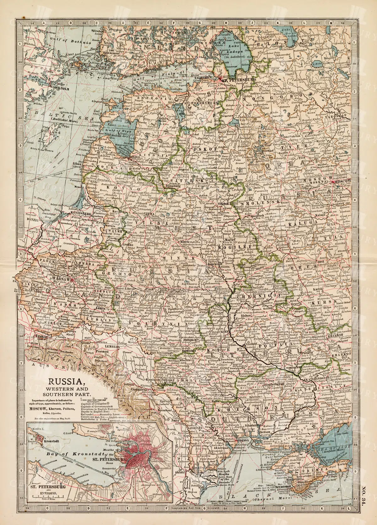
19th Century Map of Russia’s Western and Southern Parts with St. Petersburg
A detailed 19th century map highlighting the western and southern parts of Russia, including the prominent city of St. Petersburg. This vintage map showcases the political and geographical landscape of the era, featuring intricate details of cities, rivers, and borders.
- Resolution: 7257 x 5100
- Image Type(s): JPG
- 1800s
- 19th-century
- Antique
- antique cartography
- antique map
- antique paper
- archival
- Atlas
- Baltic Sea
- cartographic history
- cartography
- cities
- Eastern Europe
- european history
- geographical features
- Geography
- heritage
- historical artifact
- historical document
- historical geography
- historical information
- historical map
- historical records
- history lovers
- Map
- map of Russia
- old
- old Europe
- old map
- political divisions
- representation
- Rivers
- Russia
- Russian Empire
- southern Russia
- St. Petersburg
- St. Petersburg history
- topography
- vintage
- vintage map
- western Russia
From this collection
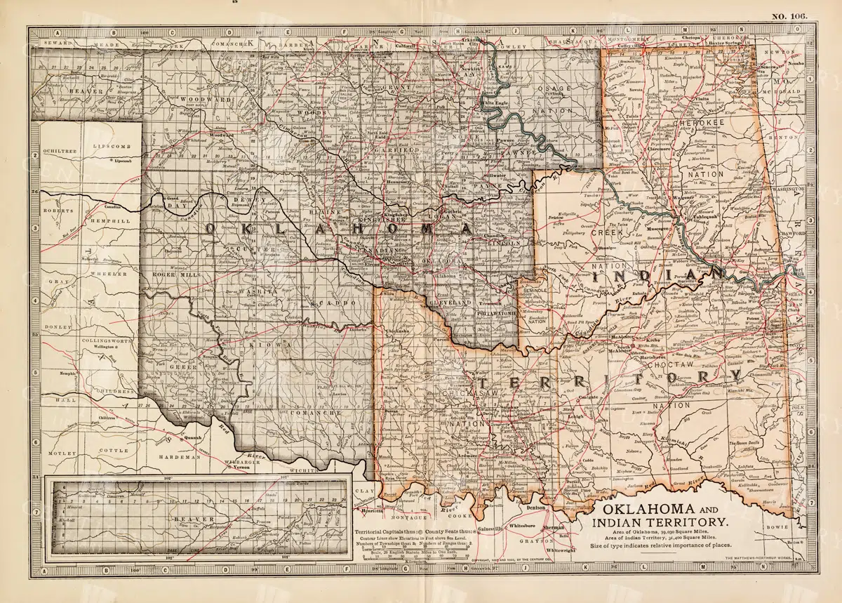
Antique Map of Oklahoma and Indian Territory from the 19th Century
This antique map from the 19th century illustrates Oklahoma and Indian Territory, showcasing the regions before statehood. It details the counties, settlements, and major transportation routes of the time.
- Resolution: 7249 x 5100
- Image Type(s): JPG
From this collection

Antique Map of Northern Ohio with Detailed City and County Lines
A historic map from the late 19th century detailing Northern Ohio, including major cities, counties, and transportation routes. This antique map highlights the region's development and infrastructure.
- Resolution: 7247 x 5100
- Image Type(s): JPG
From this collection

Historic Map of New Jersey
A detailed antique map of New Jersey, highlighting its counties, cities, and significant landmarks, reflecting the state's geography and development during the late 19th century.
- Resolution: 7239 x 5100
- Image Type(s): JPG
From this collection

Vintage Map of Nevada and Utah
An antique map detailing the states of Nevada and Utah, showcasing the topography, settlements, and infrastructure from the late 19th to early 20th century, with insets of major cities.
- Resolution: 7237 x 5100
- Image Type(s): JPG
From this collection

Antique Map of Mexico Showing Topography and Major Cities
An antique map of Mexico displaying the topography, major cities, and transportation routes, with a focus on the geographical diversity and historical boundaries from the early 20th century.
- Resolution: 7163 x 5100
- Image Type(s): JPG
From this collection

Vintage Map of Massachusetts and Surrounding Regions
A vintage map of Massachusetts showing detailed topography, cities, and transportation networks, including an inset of the Boston metropolitan area from the early 20th century.
- Resolution: 7162 x 5100
- Image Type(s): JPG
From this collection

Antique Map of Turkey in Asia with Russian Trans-Caucasia
A richly detailed antique map from the 19th century depicting Turkey in Asia, including regions like Anatolia, Armenia, Kurdistan, Mesopotamia, and Syria, along with parts of Russian Trans-Caucasia. The map highlights historical borders and settlements.
- Resolution: 7273 x 5100
- Image Type(s): JPG
From this collection

Antique Map of New Brunswick, Nova Scotia, and Prince Edward Island
A historic map from the late 19th century illustrating the Canadian provinces of New Brunswick, Nova Scotia, and Prince Edward Island, featuring key cities, towns, and geographical landmarks.
- Resolution: 7238 x 5100
- Image Type(s): JPG
- Atlantic
- princeed ward island
- novascotia
- new brunswick
- settlements
- maritime
- regions
- topography
- cities
- colonial
- cartography
- provinces
- territory
- coastline
- towns
- 19th-century
- heritage
- classic
- illustration
- Road
- tourism
- country
- vintage
- representation
- Antique
- History
- Geography
- Atlas
- World
- Landscape
- Canada
- Globe
- Rivers
- Map
- Travel
- Ocean
- Borders
From this collection

Antique Map of Western Pennsylvania from the 19th Century with Pittsburgh Inset
This antique map highlights Western Pennsylvania from the 19th century, featuring cities, counties, and transportation routes. Includes an inset of Pittsburgh and its vicinity, showcasing urban growth.
- Resolution: 7252 x 5100
- Image Type(s): JPG
From this collection

Antique Map of Southern Michigan and Urban Development
An antique map of Southern Michigan detailing urban development, major cities, and transportation networks, including Detroit, from the early 20th century.
- Resolution: 7165 x 5100
- Image Type(s): JPG
From this collection

Antique Map of Wisconsin
Historical antique map of Wisconsin, showing counties, towns, railroads, rivers, and other geographical features. A 19th century map that illustrates the development and infrastructure of the state.
- Resolution: 7281 x 5100
- Image Type(s): JPG
- 19th-century
- American history
- Antique
- Atlas
- cartographer
- cartography
- classic
- collectible
- counties
- detailed map
- education
- exploration
- geographical features
- Geography
- heritage
- heritage map
- historical
- historical development
- historical map
- historical regions
- History
- infrastructure
- Map
- nostalgic
- old map
- railroads
- reference
- representation
- Rivers
- state boundaries
- state map
- topography
- towns
- transportation
- USA
- vintage
- vintage wisconsin
- Wisconsin
- wisconsin counties
- wisconsin map
- World
From this collection

Detailed 19th Century Map of Ontario with Inset of Toronto and Vicinity
A richly detailed map of Ontario from the late 19th century, featuring county divisions, cities, and a prominent inset of Toronto and its surrounding areas, highlighting important transportation routes.
- Resolution: 7250 x 5100
- Image Type(s): JPG
From this collection

Historic Map of North Carolina
A detailed antique map of North Carolina, highlighting its counties, cities, and key geographical features, showcasing the state's landscape during the late 19th century.
- Resolution: 7243 x 5100
- Image Type(s): JPG
From this collection

Vintage Map of Northern New York
An antique map focusing on the northern and eastern parts of New York, showing the state's counties, cities, and significant natural features, typical of late 19th-century cartography.
- Resolution: 7240 x 5100
- Image Type(s): JPG
From this collection

19th Century Russia in Europe with Poland and Finland Vintage Map
A detailed 19th century map depicting Russia in Europe, including Poland and Finland. This historical artifact provides insight into the territorial boundaries and political divisions of the time, with intricate detailing of cities, rivers, and topographical features.
- Resolution: 7256 x 5100
- Image Type(s): JPG
- 1800s
- 19th-century
- Antique
- antique cartography
- antique map
- antique paper
- archival
- Atlas
- Baltic Sea
- Black Sea
- cartographic history
- cartography
- cities
- Eastern Europe
- european history
- Finland
- Finland history
- Geography
- heritage
- historical artifact
- historical document
- historical geography
- historical information
- historical map
- historical records
- history lovers
- Map
- map of Russia
- old Europe
- old map
- Poland
- Poland history
- political divisions
- representation
- Rivers
- Russia in Europe
- Russian Empire
- territorial boundaries
- topography
- vintage
- vintage map
- World
From this collection

Antique 19th Century Map of Oregon Featuring Detailed Topographical Features
A detailed antique map from the 19th century showcasing the state of Oregon, including its mountains, rivers, and settlements. This map highlights the state's topography and early infrastructure development.
- Resolution: 7251 x 5100
- Image Type(s): JPG
From this collection

Antique Map of Western New York
A detailed historic map showcasing the western part of New York, highlighting counties, cities, and geographical features, including insets of major urban areas like Buffalo and Rochester.
- Resolution: 7241 x 5100
- Image Type(s): JPG
From this collection

Historical Map of Northern Michigan and Surrounding Great Lakes
A historical map of Northern Michigan, including surrounding areas of the Great Lakes, highlighting major towns, transportation routes, and natural features from the early 20th century.
- Resolution: 7164 x 5100
- Image Type(s): JPG
From this collection

Antique Map of Maryland and Delaware with Washington D.C.
An antique map highlighting Maryland and Delaware, including insets of Washington D.C. and Baltimore, featuring roads, rivers, and county lines from the late 19th to early 20th century.
- Resolution: 7161 x 5100
- Image Type(s): JPG
- 19th
- 20th
- administrative
- American
- Antique
- Atlas
- Baltimore
- boundaries
- Capital
- cartography
- century
- City
- colonial
- county
- dc
- Delaware
- development
- early
- Geography
- heritage
- historic
- History
- infrastructure
- landmarks
- late
- Lines
- Map
- Maryland
- political
- regional
- representation
- Rivers
- Roads
- transportation
- urban
- urbanization
- vintage
- Washington
- World
From this collection

Detailed 19th Century Map of Eastern Pennsylvania with Philadelphia Inset
A historic map from the 19th century depicting Eastern Pennsylvania, including detailed county lines, cities, and an inset of Philadelphia. This map captures the region's development and growth.
- Resolution: 7253 x 5100
- Image Type(s): JPG
From this collection

Antique Map of Washington State
Antique map of Washington State, featuring towns, counties, railroads, and geographical features such as rivers and mountains. 19th century cartography highlighting the development and infrastructure of the state.
- Resolution: 7278 x 5100
- Image Type(s): JPG
- 19th-century
- American history
- Antique
- archival
- Atlas
- cartographer
- cartography
- classic
- collectible
- counties
- detailed map
- education
- exploration
- geographical features
- Geography
- heritage
- historical
- historical map
- historical washington
- History
- infrastructure
- Map
- Mountains
- northwest history
- nostalgic
- old map
- pacific northwest
- railroads
- reference
- representation
- Rivers
- state boundaries
- state development
- towns
- transportation
- USA
- vintage
- Washington
- washington geography
- washington map
- washington state
- World
From this collection

19th Century Map of Switzerland, Liechtenstein, and Parts of Austria-Hungary
A detailed antique map from the 19th century showcasing Switzerland, Liechtenstein, and parts of Austria-Hungary. The map highlights the mountainous terrain, lakes, and major cities, reflecting the historical borders and settlements of the region.
- Resolution: 7267 x 5100
- Image Type(s): JPG
From this collection

Detailed 19th Century Map of Quebec, Canada with Historical Context
A richly detailed 19th century map of Quebec, Canada, showcasing various regions, cities, and geographical features. This historical map provides a glimpse into the past, reflecting the administrative and territorial divisions of the era. Insets highlight key areas, enhancing the map's informative value.
- Resolution: 7255 x 5100
- Image Type(s): JPG
- 1800s
- 19th-century
- antique cartography
- antique map
- antique paper
- archival
- Atlas
- Canada
- Canadian history
- Canadian provinces
- cartographic history
- cartography
- cities
- country
- detailed map
- educational tool
- Geography
- geography of Quebec
- heritage
- historical artifact
- historical context
- historical document
- historical geography
- historical information
- historical map
- historical records
- history lovers
- Map
- map insets
- map of Canada
- Montreal
- North America
- old map
- old Quebec
- Quebec
- Quebec history
- regions
- representation
- St. Lawrence River
- territorial divisions
- topography
- vintage
- vintage map
- World
From this collection

Vintage Map of Montana
An antique map showcasing the state of Montana, highlighting counties, cities, and geographical features in fine detail, typical of late 19th to early 20th century cartography.
- Resolution: 7235 x 5100
- Image Type(s): JPG
From this collection

Detailed 19th Century Map of Illinois, USA
A richly detailed 19th century map of Illinois, focusing on the southern part of the state, including the area around Chicago and St. Louis. The map is intricately detailed with towns, railways, and geographical features, showcasing the state’s development during the period.
- Resolution: 7265 x 5100
- Image Type(s): JPG
- 19th-century
- America
- Antique
- antique map
- archives
- Atlas
- Borders
- cartography
- Chicago
- counties
- country
- development
- Engineering
- exploration
- Geography
- heritage
- historic
- historical
- History
- Illinois
- landmarks
- Map
- Midwest
- old map
- railways
- reference
- representation
- retro
- Rivers
- Rural
- settlements
- southern Illinois
- St. Louis
- territorial
- topographic
- topography
- towns
- transportation
- urban
- USA
- vintage
- World
From this collection

19th Century Map of South Dakota with County Divisions
A detailed 19th century map of South Dakota, showcasing the state's counties, cities, and geographical features. This vintage map offers insight into the political and territorial divisions of the era, with intricate details of rivers and topography.
- Resolution: 7264 x 5100
- Image Type(s): JPG
- 1800s
- 19th-century
- American history
- antique cartography
- antique map
- antique paper
- archival
- cartographic history
- cartography
- cities
- county divisions
- geographical features
- Geography
- heritage
- historical artifact
- historical document
- historical geography
- historical information
- historical map
- historical records
- history lovers
- Map
- map of South Dakota
- old map
- old South Dakota
- Plan
- political divisions
- representation
- South Dakota
- state map
- territorial divisions
- topography
- United States
- vintage
- vintage map
From this collection

Antique 19th Century Map of Southern Ohio Featuring Major Cities and Rivers
A detailed 19th-century map showcasing Southern Ohio, highlighting cities like Cincinnati and Cleveland, along with rivers and other key geographical features. Ideal for historical and geographical studies.
- Resolution: 7248 x 5100
- Image Type(s): JPG
From this collection

Detailed Vintage Illustration of Italian Land Crab in Natural Pose as Isolated Transparent PNG Artwork
A detailed vintage illustration of an Italian land crab in a natural pose. This transparent PNG artwork captures the intricate details of the crab's form and texture, ideal for digital and nature-themed projects.
- Resolution: 4192px x 2617px
- Image Type(s): PNG
Related Images
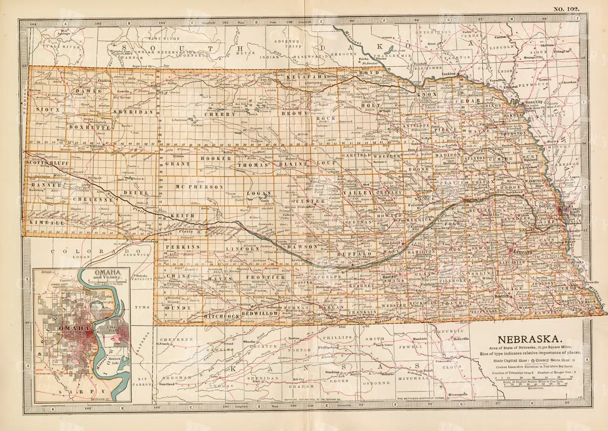
Historic Map of Nebraska
A detailed historic map of Nebraska, illustrating counties, towns, and important routes, reflecting the geography and infrastructure of the state during the late 19th to early 20th century.
- Resolution: 7236 x 5100
- Image Type(s): JPG
From this collection

Antique Map of North Dakota
A historic map of North Dakota from the late 19th century, detailing the state's counties, cities, and major geographical landmarks, reflecting its development and settlement patterns.
- Resolution: 7244 x 5100
- Image Type(s): JPG
From this collection

Vintage Engraving of Indian Elephant Drinking Water in Jungle Backdrop as Transparent PNG Illustration
An intricate vintage engraving of an Indian elephant drinking water, set against a lush jungle backdrop. This illustration captures the serene interaction of the elephant with its natural habitat, perfect for creative and nature-themed projects.
- Resolution: 2462px x 2473px
- Image Type(s): PNG
- Animal
- Art
- Background
- Black and white
- classic
- conservation
- Craft
- Design
- detailed
- digital
- Drinking
- Elephant
- elephants
- Engraving
- environment
- exotic
- Foliage
- Forest
- greenery
- habitat
- heritage
- illustration
- Indian
- ivory
- jungle
- lush
- majestic
- Mammal
- Nature
- rustic
- safari
- scene
- serene
- traditional
- tranquil
- transparent
- Tropical
- Trunk
- tusk
- tusker
- vintage
- Water
- Wild
- Wildlife
Related Images

Vintage Side Profile Engraving of Indian Elephant Bust with Prominent Trunk as Transparent PNG Illustration
A vintage side profile illustration of an Indian elephant bust, featuring a prominent trunk and textured skin. This transparent PNG provides a classic look suitable for various digital and design projects, reflecting the majestic presence of the elephant.
- Resolution: 3896px x 4897px
- Image Type(s): PNG
Related Images

Vintage Engraving of Indian Buffalo Bust with Wide Sharp Horns as Isolated Transparent PNG Illustration
A detailed vintage engraving of an Indian buffalo bust, showcasing wide and sharp horns. This transparent PNG illustration captures the intricate textures and distinct features of the buffalo, ideal for graphic design and digital projects.
- Resolution: 4115px x 3954px
- Image Type(s): PNG
- Animal
- animal art
- Antique
- Art
- Black and white
- bovine
- Buffalo
- bust
- classic
- Craft
- cultural
- Decorative
- Design
- detailed
- digital
- Drawing
- Engraving
- exotic
- Grazing
- heritage
- historic
- Horns
- illustration
- Indian
- Mammal
- natural
- Nature
- old
- old world buffalo
- pastoral
- retro
- ruminant
- rustic
- sharp
- traditional
- transparent
- vintage
- water buffalo
- wide
- Wild
- Wildlife
Related Images

Roman Statue Wearing Robes Holding Sword and Shield
A vintage illustration of a Roman statue wearing robes and holding a sword and shield, capturing the essence of ancient Roman mythology and history.
- Image Type(s): PNG
Related Images

Antique Line Art Isolated Illustration of a Christian Cross on an Anchor with Apple and Ivy
An antique line art illustration of a Christian cross over an anchor, topped with an apple and surrounded by ivy vines, symbolizing faith and tradition.
- Image Type(s): PNG
Related Images

Vintage Map of Missouri, Northern Part with Cities and Roads
A vintage map showing the northern part of Missouri, including cities, roads, and county lines, reflecting the region's infrastructure and geography from the early 20th century.
- Resolution: 7168 x 5100
- Image Type(s): JPG
From this collection

Antique Map of Mississippi with River and County Details
An antique map of Mississippi focusing on its river systems, county divisions, and major transportation routes, reflecting the state's historical geography from the early 20th century.
- Resolution: 7167 x 5100
- Image Type(s): JPG
From this collection

Support the Library
Our supporters and members help us continue collecting and restoring these wonderful pieces of art for the modern creator
Unlock Everything and Become a Member!
While a lot of the library is available for free, some is kept behind closed dusty doors only to be accessed by our lovely members.