
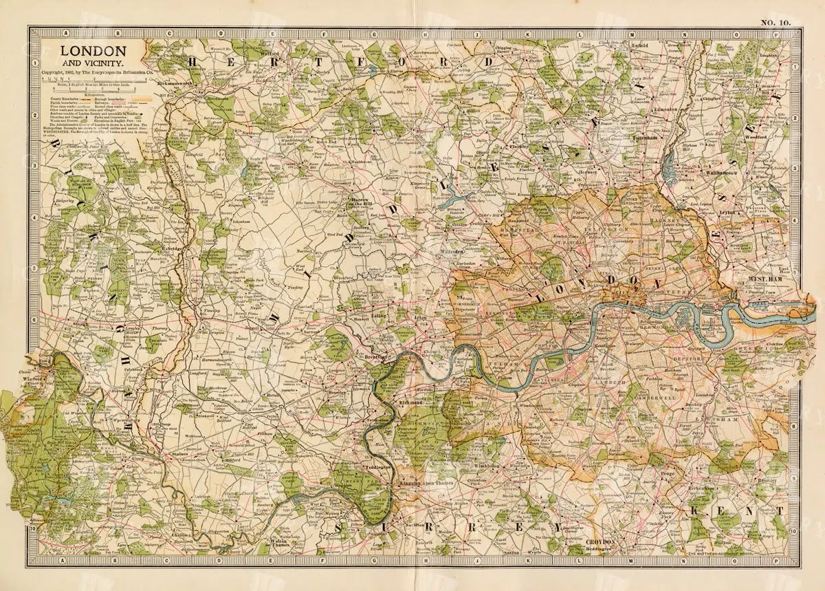
1897 Map of London and Surrounding Areas in the Late 19th Century
A detailed map from 1897 showcasing London and its surrounding areas, including key roads, railways, and landmarks. The map offers a comprehensive view of the city's layout and development during the late 19th century, providing valuable historical insights into London's urban expansion and infrastructure. The vintage aesthetic adds to its charm as a historical document.
- Resolution: 7158 x 5100
- Image Type(s): JPG
From this collection

Antique Map of Philippine Islands and Hawaiian Islands with Inset Maps
A detailed 19th-century map showcasing the Philippine Islands and Hawaiian Islands, complete with inset maps of major cities like Manila and Honolulu. This map is ideal for historical and geographical research.
- Resolution: 7254 x 5100
- Image Type(s): JPG
From this collection

Antique Map of Northern Ohio with Detailed City and County Lines
A historic map from the late 19th century detailing Northern Ohio, including major cities, counties, and transportation routes. This antique map highlights the region's development and infrastructure.
- Resolution: 7247 x 5100
- Image Type(s): JPG
From this collection

Antique Map of Mexico Showing Topography and Major Cities
An antique map of Mexico displaying the topography, major cities, and transportation routes, with a focus on the geographical diversity and historical boundaries from the early 20th century.
- Resolution: 7163 x 5100
- Image Type(s): JPG
From this collection
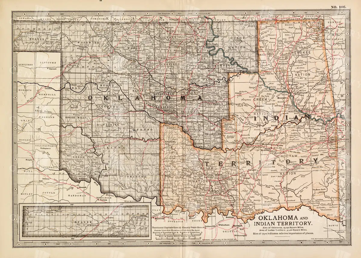
Antique Map of Oklahoma and Indian Territory from the 19th Century
This antique map from the 19th century illustrates Oklahoma and Indian Territory, showcasing the regions before statehood. It details the counties, settlements, and major transportation routes of the time.
- Resolution: 7249 x 5100
- Image Type(s): JPG
From this collection

Vintage Map of Minnesota Featuring Lakes and Urban Areas
A vintage map of Minnesota highlighting its numerous lakes, urban areas, and transportation routes, showcasing the state's geographical diversity from the early 20th century.
- Resolution: 7166 x 5100
- Image Type(s): JPG
From this collection

Vintage Map of Nevada and Utah
An antique map detailing the states of Nevada and Utah, showcasing the topography, settlements, and infrastructure from the late 19th to early 20th century, with insets of major cities.
- Resolution: 7237 x 5100
- Image Type(s): JPG
From this collection

Vintage Map of Massachusetts and Surrounding Regions
A vintage map of Massachusetts showing detailed topography, cities, and transportation networks, including an inset of the Boston metropolitan area from the early 20th century.
- Resolution: 7162 x 5100
- Image Type(s): JPG
From this collection

1897 Map of Italy: Northern Regions
This 1897 map offers a comprehensive view of Northern Italy, detailing its cities, mountain ranges, and infrastructure. The map covers important regions such as Piedmont, Lombardy, and Veneto, highlighting the area's rich history and development during the 19th century. It serves as a valuable historical document for understanding Italy's northern landscape at the time.
- Resolution: 7152 x 5100
- Image Type(s): JPG
From this collection

Detailed 19th Century Map of Ontario with Inset of Toronto and Vicinity
A richly detailed map of Ontario from the late 19th century, featuring county divisions, cities, and a prominent inset of Toronto and its surrounding areas, highlighting important transportation routes.
- Resolution: 7250 x 5100
- Image Type(s): JPG
From this collection

Historical Map of Manitoba, British Columbia, and the Northwest Territories
A detailed historical map depicting the regions of Manitoba, British Columbia, and the Northwest Territories, showcasing topographical features, settlements, and boundaries in the early 20th century.
- Resolution: 7160 x 5100
- Image Type(s): JPG
- topographical
- northwest
- columbia
- manitoba
- settlements
- early
- 20th
- demographics
- century
- provincial
- division
- resources
- settlement
- climate
- infrastructure
- regions
- boundaries
- colonial
- territories
- exploration
- cartography
- transportation
- coastline
- historical
- natural
- vintage
- representation
- Antique
- History
- River
- Geography
- Atlas
- British
- World
- Landscape
- Canada
- Globe
- Map
- Travel
- Borders
From this collection

Antique Map of Wisconsin
Historical antique map of Wisconsin, showing counties, towns, railroads, rivers, and other geographical features. A 19th century map that illustrates the development and infrastructure of the state.
- Resolution: 7281 x 5100
- Image Type(s): JPG
- nostalgic
- cartographer
- state boundaries
- historical regions
- heritage map
- wisconsin map
- wisconsin counties
- vintage wisconsin
- historical development
- state map
- reference
- geographical features
- USA
- infrastructure
- railroads
- detailed map
- topography
- historical map
- exploration
- old map
- cartography
- American history
- transportation
- counties
- towns
- education
- 19th-century
- collectible
- historical
- heritage
- classic
- vintage
- representation
- Antique
- History
- Wisconsin
- Geography
- Atlas
- World
- Rivers
- Map
From this collection

Antique Map of Western Pennsylvania from the 19th Century with Pittsburgh Inset
This antique map highlights Western Pennsylvania from the 19th century, featuring cities, counties, and transportation routes. Includes an inset of Pittsburgh and its vicinity, showcasing urban growth.
- Resolution: 7252 x 5100
- Image Type(s): JPG
From this collection

Antique Map of Southern Michigan and Urban Development
An antique map of Southern Michigan detailing urban development, major cities, and transportation networks, including Detroit, from the early 20th century.
- Resolution: 7165 x 5100
- Image Type(s): JPG
From this collection

Historical Map of Northern Michigan and Surrounding Great Lakes
A historical map of Northern Michigan, including surrounding areas of the Great Lakes, highlighting major towns, transportation routes, and natural features from the early 20th century.
- Resolution: 7164 x 5100
- Image Type(s): JPG
From this collection

1897 Map of Kansas with Detailed County Lines and Railroads
A historical map from 1897 showing Kansas with a focus on county lines, railroads, and major cities. The map provides a detailed representation of the state's infrastructure and development during the late 19th century, offering valuable insights into the region's history and growth. The vintage design adds to its appeal as a historical artifact.
- Resolution: 7156 x 5100
- Image Type(s): JPG
From this collection

Detailed 19th Century Map of Eastern Pennsylvania with Philadelphia Inset
A historic map from the 19th century depicting Eastern Pennsylvania, including detailed county lines, cities, and an inset of Philadelphia. This map captures the region's development and growth.
- Resolution: 7253 x 5100
- Image Type(s): JPG
From this collection

Antique 19th Century Map of Oregon Featuring Detailed Topographical Features
A detailed antique map from the 19th century showcasing the state of Oregon, including its mountains, rivers, and settlements. This map highlights the state's topography and early infrastructure development.
- Resolution: 7251 x 5100
- Image Type(s): JPG
From this collection

Antique Map of Maryland and Delaware with Washington D.C.
An antique map highlighting Maryland and Delaware, including insets of Washington D.C. and Baltimore, featuring roads, rivers, and county lines from the late 19th to early 20th century.
- Resolution: 7161 x 5100
- Image Type(s): JPG
- development
- early
- 20th
- administrative
- urbanization
- 19th
- late
- county
- dc
- century
- infrastructure
- boundaries
- colonial
- cartography
- transportation
- regional
- political
- landmarks
- historic
- heritage
- urban
- Roads
- vintage
- representation
- Lines
- Antique
- History
- Washington
- Delaware
- Baltimore
- Maryland
- Geography
- Atlas
- American
- City
- World
- Rivers
- Map
- Capital
From this collection

Antique Map of Washington State
Antique map of Washington State, featuring towns, counties, railroads, and geographical features such as rivers and mountains. 19th century cartography highlighting the development and infrastructure of the state.
- Resolution: 7278 x 5100
- Image Type(s): JPG
- nostalgic
- cartographer
- state boundaries
- washington state
- state development
- historical washington
- pacific northwest
- washington map
- northwest history
- washington geography
- reference
- archival
- geographical features
- USA
- infrastructure
- railroads
- detailed map
- historical map
- exploration
- old map
- cartography
- American history
- transportation
- counties
- towns
- education
- 19th-century
- collectible
- historical
- heritage
- classic
- vintage
- representation
- Antique
- History
- Washington
- Geography
- Atlas
- World
- Rivers
- Mountains
- Map
From this collection

1897 Map of Kentucky Featuring Counties, Railways, and Rivers
This 1897 map of Kentucky highlights the state's counties, railways, and rivers, offering a detailed look at the region's geography and infrastructure during the late 19th century. The map serves as a valuable resource for understanding Kentucky's development, with a focus on transportation and regional divisions. The vintage cartography style enhances its historical significance.
- Resolution: 7157 x 5100
- Image Type(s): JPG
From this collection

Antique 19th Century Map of Southern Ohio Featuring Major Cities and Rivers
A detailed 19th-century map showcasing Southern Ohio, highlighting cities like Cincinnati and Cleveland, along with rivers and other key geographical features. Ideal for historical and geographical studies.
- Resolution: 7248 x 5100
- Image Type(s): JPG
From this collection

Vintage Map of Northern Illinois Featuring Chicago and Surrounding Areas
This vintage map of Northern Illinois features Chicago and its surrounding areas, highlighting major transportation routes, rivers, and urban centers. The map provides a detailed overview of the region's geography during the early 20th century, showcasing the development and expansion of Chicago as a key American city. It offers a historical perspective on the infrastructure and urban planning of the time.
- Resolution: 7142 x 5100
- Image Type(s): JPG
From this collection

Vintage Map of Indiana Highlighting Transportation Networks and County Borders
This vintage map of Indiana highlights the state's transportation networks, including roads and railroads, along with its county borders. The map provides a detailed view of Indiana's geography during the early 20th century, focusing on the development of infrastructure and urban areas. It offers a historical overview of the state's growth and the connections between its cities and rural areas.
- Resolution: 7146 x 5100
- Image Type(s): JPG
From this collection

Detailed Antique Map of Iowa with County Boundaries and Transportation Routes
This detailed antique map of Iowa showcases the state's county boundaries, major cities, and transportation routes, including roads and railroads. The map provides a comprehensive view of Iowa's geography during the early 20th century, highlighting the state's agricultural landscape and infrastructure development. It serves as a valuable resource for understanding Iowa's historical growth and its place in the broader Midwest.
- Resolution: 7147 x 5100
- Image Type(s): JPG
From this collection

Vintage Map of Missouri, Northern Part with Cities and Roads
A vintage map showing the northern part of Missouri, including cities, roads, and county lines, reflecting the region's infrastructure and geography from the early 20th century.
- Resolution: 7168 x 5100
- Image Type(s): JPG
From this collection

Antique Map of Mississippi with River and County Details
An antique map of Mississippi focusing on its river systems, county divisions, and major transportation routes, reflecting the state's historical geography from the early 20th century.
- Resolution: 7167 x 5100
- Image Type(s): JPG
From this collection

Antique Map of Southern Missouri with Transportation Networks
An antique map of Southern Missouri detailing transportation networks, including railroads and highways, alongside topographical features from the early 20th century.
- Resolution: 7169 x 5100
- Image Type(s): JPG
From this collection

Support the Library
Our supporters and members help us continue collecting and restoring these wonderful pieces of art for the modern creator
Unlock Everything and Become a Member!
While a lot of the library is available for free, some is kept behind closed dusty doors only to be accessed by our lovely members.