

Vintage Map of Ireland Highlighting Political Boundaries and Topographical Features
This vintage map of Ireland highlights the country's political boundaries and key topographical features, including rivers, mountains, and major cities. The map provides a historical overview of Ireland during the late 19th century, offering insight into the geopolitical landscape and cultural heritage of the island. It includes detailed insets of Dublin and its surrounding areas, reflecting Ireland's rich history and complex political past.
- Resolution: 7149 x 5100
- Image Type(s): JPG
- Antique
- antique map
- Atlas
- cartography
- cities
- cultural heritage
- Dublin
- Europe
- exploration
- Geography
- geopolitical
- historical geography
- historical map
- History
- Ireland
- Ireland history
- Irish history
- Island
- Landscape
- late 19th century
- Map
- Mountains
- old map
- political boundaries
- representation
- Rivers
- topography
- United Kingdom
- vintage
- World
From this collection

WORLD MAP Physical Map of Mountain-Chains and River Systems. 1880 Stock Image
An original Antique Plate scan from the National Encyclopaedia: A Dictionary of Universal Knowledge. Published by William Mackenzie in 1880. Click on the Artist's name to see the full collection from this series!
- License Info
- Resolution: 7594 x 10009 300dpi
- Year of Print: 1880
- Artist: William Mackenzie
From this collection

Engraved Village Scene with Tower, Mountain Landscape, and Winding Path
This image is part of a beautiful collection of highly detailed, engraved illustrations from the early 1800s - Originally discovered within a small book full of stories inspired by the English countryside. While I’m sure the stories are lovely, I couldn’t get over how incredible these illustrations were!
- Image Type(s): PNG
From this collection
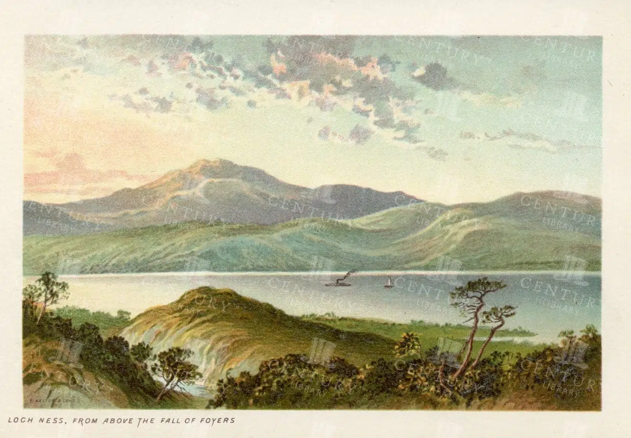
LOCH NESS from above the Fall of Foyers, Vintage 1895 Illustration
- Resolution: 4749px x 3240px
- Year of Print: 1895
- Artist: T. Nelson and Sons
Related Images

Antique 19th Century Map of Norway and Sweden with Topographical Details
A beautifully detailed antique map from the 19th century showcasing the countries of Norway and Sweden, with topographical features, major cities, and inset maps of Kristiana and Stockholm.
- Resolution: 7245 x 5100
- Image Type(s): JPG
From this collection
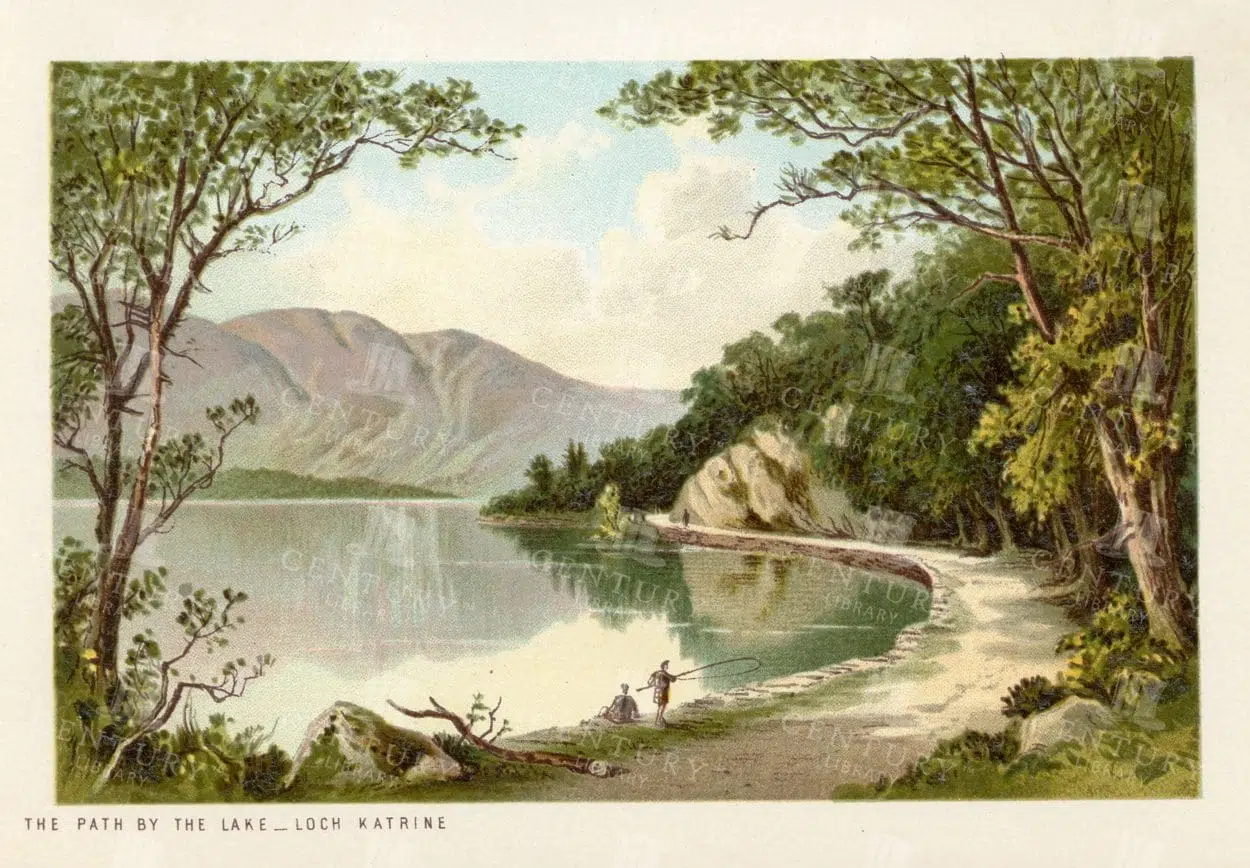
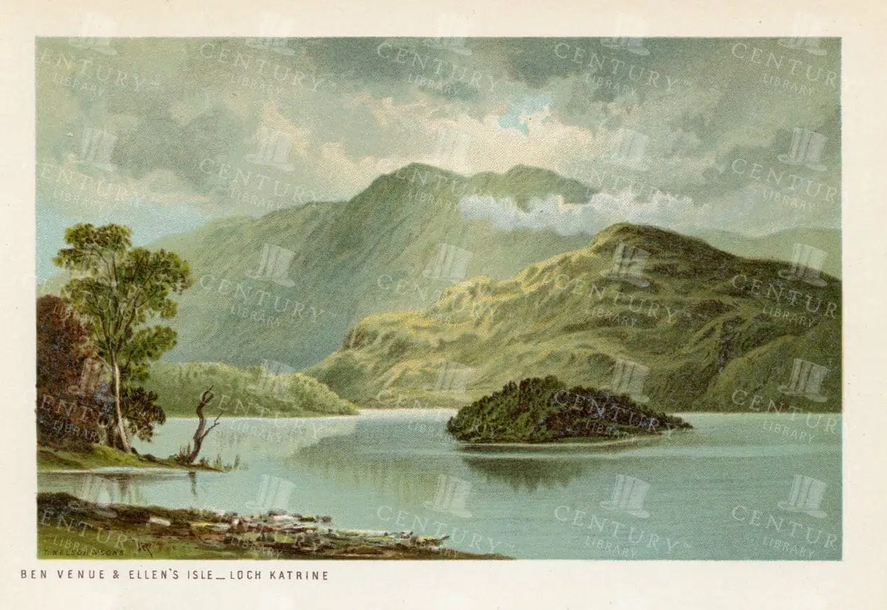
VINTAGE Landscape Illustration – The Path by the Lake, Loch Katrine
- Resolution: 4706px x 3239px
- Year of Print: 1895
- Artist: T. Nelson and Sons
Related Images


19th Century Map of Spain, Portugal, and Andorra
An antique map from the 19th century detailing the countries of Spain, Portugal, and Andorra, along with surrounding regions. The map features important cities, mountain ranges, and bodies of water, offering a glimpse into the historical geography of the Iberian Peninsula.
- Resolution: 7266 x 5100
- Image Type(s): JPG
- 19th-century
- Andorra
- Antique
- archives
- Atlantic
- Atlas
- Borders
- cartography
- cities
- country
- Europe
- exploration
- Geography
- heritage
- historic map
- historical
- History
- Iberian Peninsula
- landmarks
- Landscape
- Map
- Mediterranean
- Mountains
- old map
- Portugal
- Pyrenees
- reference
- representation
- retro
- Rivers
- settlements
- Spain
- topographic
- vintage
- vintage map
- World
From this collection


Antique Map of Mexico Showing Topography and Major Cities
An antique map of Mexico displaying the topography, major cities, and transportation routes, with a focus on the geographical diversity and historical boundaries from the early 20th century.
- Resolution: 7163 x 5100
- Image Type(s): JPG
From this collection


Vintage Map of Nevada and Utah
An antique map detailing the states of Nevada and Utah, showcasing the topography, settlements, and infrastructure from the late 19th to early 20th century, with insets of major cities.
- Resolution: 7237 x 5100
- Image Type(s): JPG
From this collection
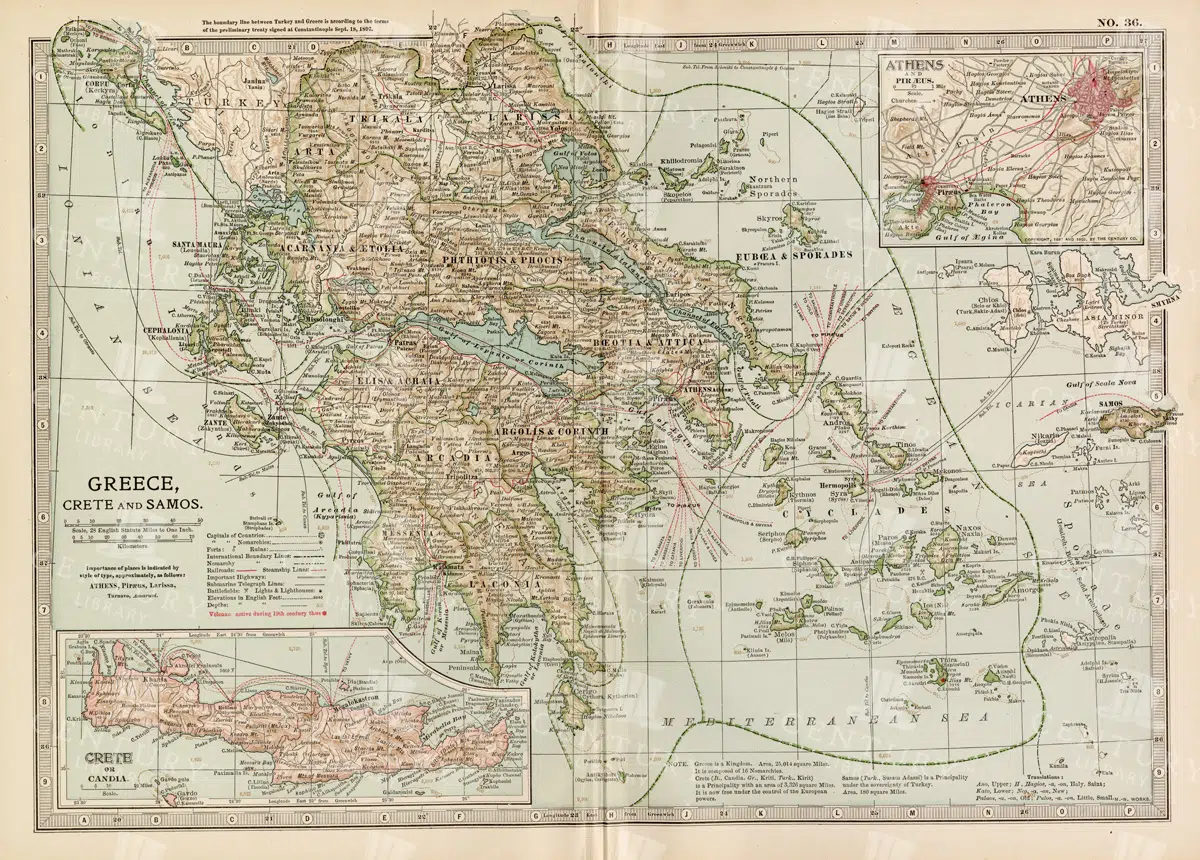
Antique Map of Greece Highlighting Crete and Samos with Detailed Topography
This antique map of Greece highlights the regions of Crete and Samos, showing detailed topographical features such as mountains, rivers, and coastlines. The map provides a historical overview of the geopolitical boundaries, major cities, and maritime routes in the Aegean Sea during the late 19th century. It offers a valuable perspective on the landscape and political divisions of Greece and its islands at the time.
- Resolution: 7140 x 5100
- Image Type(s): JPG
From this collection


Historic Map of North Carolina
A detailed antique map of North Carolina, highlighting its counties, cities, and key geographical features, showcasing the state's landscape during the late 19th century.
- Resolution: 7243 x 5100
- Image Type(s): JPG
From this collection

Vintage Map of Northern New York
An antique map focusing on the northern and eastern parts of New York, showing the state's counties, cities, and significant natural features, typical of late 19th-century cartography.
- Resolution: 7240 x 5100
- Image Type(s): JPG
From this collection


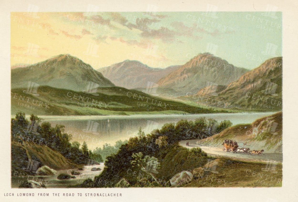
STUNNING Vintage Scottish Illustration – Luss Straits -Loch Lomond
- Resolution: 4706px x 3211px
- Year of Print: 1895
- Artist: T. Nelson and Sons
Related Images


Antique Map of Washington State
Antique map of Washington State, featuring towns, counties, railroads, and geographical features such as rivers and mountains. 19th century cartography highlighting the development and infrastructure of the state.
- Resolution: 7278 x 5100
- Image Type(s): JPG
- nostalgic
- cartographer
- state boundaries
- washington state
- state development
- historical washington
- pacific northwest
- washington map
- northwest history
- washington geography
- reference
- archival
- geographical features
- USA
- infrastructure
- railroads
- detailed map
- historical map
- exploration
- old map
- cartography
- American history
- transportation
- counties
- towns
- education
- 19th-century
- collectible
- historical
- heritage
- classic
- vintage
- representation
- Antique
- History
- Washington
- Geography
- Atlas
- World
- Rivers
- Mountains
- Map
From this collection

19th Century Map of Switzerland, Liechtenstein, and Parts of Austria-Hungary
A detailed antique map from the 19th century showcasing Switzerland, Liechtenstein, and parts of Austria-Hungary. The map highlights the mountainous terrain, lakes, and major cities, reflecting the historical borders and settlements of the region.
- Resolution: 7267 x 5100
- Image Type(s): JPG
From this collection

Historical Map of Idaho and Wyoming Including Yellowstone National Park
This historical map covers the states of Idaho and Wyoming, with a special focus on Yellowstone National Park. The map details the topographical features, including mountains, rivers, and forests, as well as the transportation routes and political boundaries of the early 20th century. It provides a valuable snapshot of the American West during this period, highlighting the natural beauty and geographical diversity of the region.
- Resolution: 7141 x 5100
- Image Type(s): JPG
- early 20th century
- Yellowstone National Park
- Idaho
- Western states
- national parks
- forests
- topography
- historical geography
- antique map
- historical map
- exploration
- old map
- cartography
- American West
- political boundaries
- transportation
- conservation
- historical
- vintage
- old
- representation
- Antique
- History
- Wyoming
- Geography
- Landscape
- United States
- Rivers
- Mountains
- Map
From this collection


ANTIQUE 1895 Landscape Illustration – The Monastery, Fort Augustus
- Resolution: 4763px x 3268px
- Year of Print: 1895
- Artist: T. Nelson and Sons
Related Images


LOCH GOILHEAD – Vintage Scottish Landscape Chromo Illustration
- Resolution: 4749px x 3197px
- Year of Print: 1895
- Artist: T. Nelson and Sons
Related Images


VINTAGE 1895 Illustration – The Ardgower Mountains from Ballachulish
- Resolution: 4804px x 3284px
- Year of Print: 1895
- Artist: T. Nelson and Sons
Related Images


LOCH LOMOND, Pass of Balmaha – Vintage 1895 Landscape Illustration
- Resolution: 4706px x 3211px
- Year of Print: 1895
- Artist: T. Nelson and Sons
Related Images


BRODICK BAY & Goatfell – Vintage Scottish Landscape Illustration
- Resolution: 4747px x 3270px
- Year of Print: 1895
- Artist: T. Nelson and Sons
Related Images


Support the Library
Our supporters and members help us continue collecting and restoring these wonderful pieces of art for the modern creator
Unlock Everything and Become a Member!
While a lot of the library is available for free, some is kept behind closed dusty doors only to be accessed by our lovely members.