

Antique Map of Northern France Including the English Channel and Paris
This antique map of Northern France illustrates the region’s towns, roads, and geographical features, including Paris and the English Channel. The map provides a detailed representation of the historical geography of the area, showing the connections between key locations. Its vintage aesthetic adds charm, making it a must-have for history enthusiasts and map collectors. Insets highlight additional regions, enhancing the map's utility and appeal.
- Resolution: 7134 x 5100
- Image Type(s): JPG
- antique map
- Atlas
- detailed map
- english channel
- english channel map
- France
- france cartography
- france history
- france regions
- france towns
- france vintage
- french cartography
- french geography
- french history
- french map
- Geography
- historical
- historical france map
- historical geography
- historical map
- Map
- northern
- northern france
- old france map
- old map
- Paris
- paris geography
- paris map
- representation
- Roads
- towns
- vintage
- vintage cartography
- vintage france
- World
From this collection
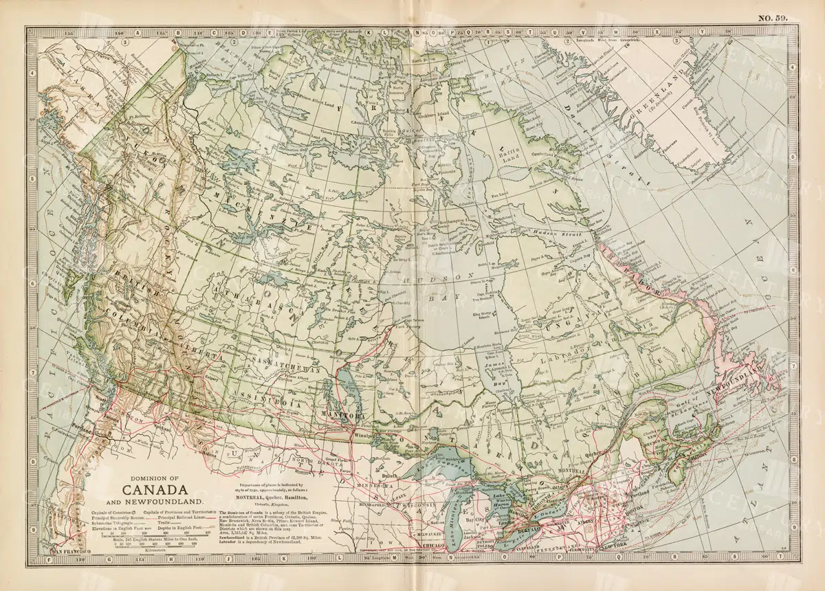
Antique Map of Canada and Newfoundland Highlighting Major Cities and Natural Features
An antique map of Canada and Newfoundland, offering a detailed look at the region's cities, natural landmarks, and geographical features. The map provides insights into the historical significance of the area during the time of its creation.
- Resolution: 7115 x 5100
- Image Type(s): JPG
From this collection

Antique Map of Northern Ohio with Detailed City and County Lines
A historic map from the late 19th century detailing Northern Ohio, including major cities, counties, and transportation routes. This antique map highlights the region's development and infrastructure.
- Resolution: 7247 x 5100
- Image Type(s): JPG
From this collection

Antique Map of Northern England Including Northumberland, Durham, and Isle of Man
An antique map of Northern England, showcasing regions like Northumberland and Durham, as well as the Isle of Man inset. The map provides detailed insights into the region's historical geography, including towns, transportation routes, and coastal features.
- Resolution: 7124 x 5100
- Image Type(s): JPG
From this collection

Vintage Map of Northern England and Wales Highlighting Major Cities and Geographic Features
A vintage map of Northern England and Wales, detailing major cities, towns, and geographical features. The map includes important transportation routes and provides a historical overview of the region during the period.
- Resolution: 7125 x 5100
- Image Type(s): JPG
From this collection

Vintage Map of Northern New York
An antique map focusing on the northern and eastern parts of New York, showing the state's counties, cities, and significant natural features, typical of late 19th-century cartography.
- Resolution: 7240 x 5100
- Image Type(s): JPG
From this collection

Historical Map of Northern Michigan and Surrounding Great Lakes
A historical map of Northern Michigan, including surrounding areas of the Great Lakes, highlighting major towns, transportation routes, and natural features from the early 20th century.
- Resolution: 7164 x 5100
- Image Type(s): JPG
From this collection

Detailed Map of the Northern Part of the German Empire with Key Cities
This detailed map of the northern part of the German Empire highlights key cities such as Hamburg and Berlin, along with roads and geographical features. The map offers a historical perspective on the region's landscape and its urban development during the time period. Its vintage style and detailed cartography make it an invaluable resource for collectors and history enthusiasts. The map’s detailed depiction of the area’s geography is a window into the past.
- Resolution: 7138 x 5100
- Image Type(s): JPG
- Antique
- antique geography
- antique map
- Atlas
- Berlin
- berlin map
- detailed german map
- detailed map
- Geography
- german cartography
- german cities
- german empire
- german empire map
- german geography
- german history
- german regions
- german towns
- german vintage
- hamburg
- hamburg map
- historical
- historical geography
- historical german map
- historical germany map
- historical map
- Map
- northern
- northern german map
- northern germany
- old germany map
- old map
- representation
- Roads
- towns
- vintage
- vintage cartography
- vintage germany
- World
From this collection

Vintage Map of Northern California Including San Francisco and Yosemite Valley
A vintage map depicting the northern part of California, highlighting major cities like San Francisco and natural landmarks such as Yosemite Valley. The map provides detailed insights into the region's geographical features, transportation routes, and historical importance.
- Resolution: 7113 x 5100
- Image Type(s): JPG
From this collection

Northern Sea Lions on Coast Pack Illustration in Line Art
Line art illustration of a pack of Northern Sea Lions on the coast, showcasing their robust bodies and natural marine habitat
- Resolution: 4733px x 3907px
- Image Type(s): PNG
Related Images

Vintage Map of Missouri, Northern Part with Cities and Roads
A vintage map showing the northern part of Missouri, including cities, roads, and county lines, reflecting the region's infrastructure and geography from the early 20th century.
- Resolution: 7168 x 5100
- Image Type(s): JPG
From this collection

Support the Library
Our supporters and members help us continue collecting and restoring these wonderful pieces of art for the modern creator
Unlock Everything and Become a Member!
While a lot of the library is available for free, some is kept behind closed dusty doors only to be accessed by our lovely members.