

1897 Map of Italy: Comprehensive View Including Rome and Venice
A detailed 1897 map of Italy, encompassing the entire peninsula including key cities like Rome and Venice. This map highlights the topographical features, transportation networks, and regional boundaries of Italy during the late 19th century. It offers a broad view of Italy's geography and historical development, making it a significant resource for historical studies.
- Resolution: 7153 x 5100
- Image Type(s): JPG
From this collection

Antique Map of the United States
Detailed antique map of the United States showing states, territories, railroads, and cities, with inset of Alaska. Includes topographical features, rivers, and mountain ranges.
- Resolution: 7275 x 5100
- Image Type(s): JPG
- state lines
- united states map
- nostalgic
- america map
- cartographer
- reference
- archival
- USA
- topographical
- mountain ranges
- railroads
- cities
- antique map
- historical map
- territories
- exploration
- old map
- cartography
- vintage map
- American history
- transportation
- states
- historic
- education
- 19th-century
- collectible
- historical
- detailed
- heritage
- illustration
- vintage
- Atlantic Ocean
- Antique
- History
- Alaska
- Pacific Ocean
- Geography
- United States
- America
- Rivers
- Map
- Borders
From this collection

Old Line Art Illustration of a Penny Farthing Bicycle
A vintage line art illustration of a penny farthing bicycle, showcasing its iconic large front wheel design. Ideal for transportation and historical-themed projects.
- Image Type(s): PNG
Related Images

Vintage Map of Southern England and Wales Highlighting Major Cities and Coastal Areas
This vintage map of Southern England and Wales highlights major cities, coastal areas, and important transportation routes. The map provides detailed insights into the region's historical geography and urban development during the period.
- Resolution: 7127 x 5100
- Image Type(s): JPG
From this collection

Antique Map of the West Indies
Historical antique map of the West Indies, showcasing islands like Cuba, Jamaica, and Puerto Rico, with detailed nautical routes, ports, and topography. Includes inset of Bermuda. 19th century cartography.
- Resolution: 7279 x 5100
- Image Type(s): JPG
- nostalgic
- cartographer
- cuba
- puerto rico
- nautical routes
- ports
- bermuda
- islands map
- sea routes
- bermuda map
- west indies map
- island history
- archival
- Caribbean islands
- Caribbean
- detailed map
- maritime
- topography
- historical map
- exploration
- old map
- cartography
- transportation
- 19th-century
- collectible
- historical
- heritage
- classic
- Islands
- country
- vintage
- representation
- Atlantic Ocean
- Antique
- History
- Jamaica
- West Indies
- Geography
- Atlas
- World
- Map
- Nautical
From this collection

Detailed Historical Map of the East India Islands Including Malaysia and the Philippines
A detailed historical map of the East India Islands, including regions like Malaysia, the Philippines, and New Guinea. The map highlights important geographical features, cities, and maritime routes, offering a glimpse into the region's colonial history.
- Resolution: 7123 x 5100
- Image Type(s): JPG
From this collection

Antique Map of Texas, Western Part with Galveston Bay
A vintage 19th century map depicting the western part of Texas along with a detailed inset of Galveston Bay, Houston, and surrounding areas. The map highlights the state’s development, including railroads, towns, and natural features.
- Resolution: 7270 x 5100
- Image Type(s): JPG
From this collection

Antique Map of Vermont and New Hampshire
Detailed antique map showing the states of Vermont and New Hampshire with towns, railroads, rivers, and geographical features. Historical cartography showcasing 19th century state boundaries and infrastructures.
- Resolution: 7276 x 5100
- Image Type(s): JPG
- state lines
- nostalgic
- cartographer
- state boundaries
- infrastructures
- vermont map
- new hampshire map
- reference
- archival
- geographical features
- USA
- railroads
- detailed map
- historical map
- exploration
- old map
- cartography
- vintage map
- American history
- transportation
- states
- towns
- historic
- education
- 19th-century
- collectible
- historical
- heritage
- classic
- vintage
- representation
- Atlantic Ocean
- Antique
- History
- New England
- Vermont
- New Hampshire
- Geography
- Atlas
- Rivers
- Map
- Borders
From this collection

Antique Map of Virginia
Historical antique map of Virginia, showing counties, towns, railroads, rivers, and geographical details. Includes insets of the western part of Virginia and the Norfolk vicinity. 19th century cartography.
- Resolution: 7277 x 5100
- Image Type(s): JPG
- nostalgic
- cartographer
- state boundaries
- geographical details
- virginia map
- western virginia
- norfolk
- virginia counties
- historical regions
- reference
- archival
- USA
- railroads
- detailed map
- historical map
- exploration
- old map
- cartography
- American history
- transportation
- counties
- towns
- historic
- education
- 19th-century
- collectible
- historical
- heritage
- classic
- vintage
- old
- representation
- Atlantic Ocean
- Antique
- History
- Virginia
- Geography
- Atlas
- Rivers
- Map
From this collection

Vintage Map of Southern England Including London, Brighton, and Major Coastal Cities
A vintage map of Southern England, highlighting major cities like London and Brighton, as well as coastal areas. The map provides detailed insights into the region's historical geography, transportation routes, and urban development.
- Resolution: 7129 x 5100
- Image Type(s): JPG
From this collection

Detailed Line Art Illustration of an Old Locomotive
A detailed vintage line art illustration of an old locomotive, showcasing the intricate design and mechanical components of historic trains.
- Image Type(s): PNG
Related Images

Antique Map of West Virginia
Detailed antique map of West Virginia, showing counties, towns, railroads, and geographical features. Historical 19th century cartography with insets of surrounding areas. An educational and collectible piece.
- Resolution: 7280 x 5100
- Image Type(s): JPG
- nostalgic
- cartographer
- state boundaries
- historical regions
- west virginia map
- west virginia counties
- surrounding areas
- heritage map
- vintage west virginia
- state map
- reference
- archival
- geographical features
- USA
- railroads
- detailed map
- topography
- historical map
- exploration
- old map
- cartography
- American history
- transportation
- counties
- towns
- education
- 19th-century
- collectible
- historical
- heritage
- classic
- vintage
- old
- representation
- Antique
- History
- West Virginia
- Geography
- Atlas
- World
- Globe
- Map
From this collection

Antique Map of Northern Ohio with Detailed City and County Lines
A historic map from the late 19th century detailing Northern Ohio, including major cities, counties, and transportation routes. This antique map highlights the region's development and infrastructure.
- Resolution: 7247 x 5100
- Image Type(s): JPG
From this collection

Antique Map of Mexico Showing Topography and Major Cities
An antique map of Mexico displaying the topography, major cities, and transportation routes, with a focus on the geographical diversity and historical boundaries from the early 20th century.
- Resolution: 7163 x 5100
- Image Type(s): JPG
From this collection

Antique Map of Western England and Wales Including Detailed Regional Boundaries
An antique map of Western England and Wales, showcasing detailed regional boundaries and cities like Liverpool and Manchester. The map highlights important geographical features, transportation routes, and historical landmarks in the area.
- Resolution: 7126 x 5100
- Image Type(s): JPG
From this collection

Detailed Vintage Map of Central America Including Guatemala and Nicaragua
A detailed vintage map of Central America, featuring countries like Guatemala and Nicaragua. The map highlights important geographical features, cities, and transportation routes, providing a historical perspective on the region.
- Resolution: 7116 x 5100
- Image Type(s): JPG
From this collection

Historic Map of New Jersey
A detailed antique map of New Jersey, highlighting its counties, cities, and significant landmarks, reflecting the state's geography and development during the late 19th century.
- Resolution: 7239 x 5100
- Image Type(s): JPG
From this collection

Vintage Map of Minnesota Featuring Lakes and Urban Areas
A vintage map of Minnesota highlighting its numerous lakes, urban areas, and transportation routes, showcasing the state's geographical diversity from the early 20th century.
- Resolution: 7166 x 5100
- Image Type(s): JPG
From this collection

1897 Map of Italy: Central and Southern Regions
A detailed 1897 map highlighting the central and southern regions of Italy, including Sicily. The map showcases the topography, cities, and transportation routes of the time, providing a rich historical context of Italy during the late 19th century. The map includes notable cities such as Naples, Rome, and Palermo, along with detailed depictions of the surrounding areas.
- Resolution: 7151 x 5100
- Image Type(s): JPG
From this collection

Antique Map of Northern England Including Northumberland, Durham, and Isle of Man
An antique map of Northern England, showcasing regions like Northumberland and Durham, as well as the Isle of Man inset. The map provides detailed insights into the region's historical geography, including towns, transportation routes, and coastal features.
- Resolution: 7124 x 5100
- Image Type(s): JPG
From this collection
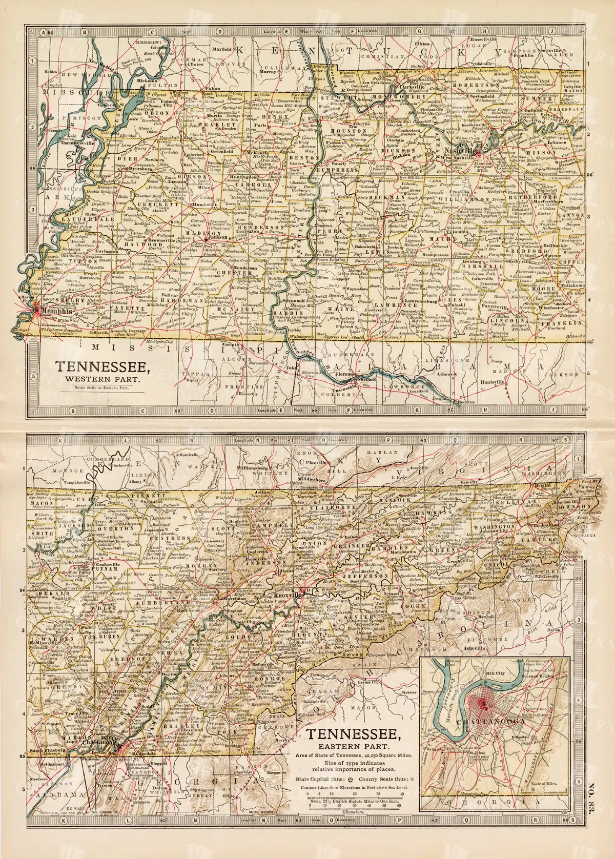
Antique Map of Tennessee, USA – Eastern and Western Parts
An antique map from the 19th century depicting both the eastern and western parts of Tennessee, USA. The map shows various towns, railways, and natural features, providing a comprehensive view of the state’s geography and development during the period.
- Resolution: 7268 x 5100
- Image Type(s): JPG
From this collection

Vintage Map of Massachusetts and Surrounding Regions
A vintage map of Massachusetts showing detailed topography, cities, and transportation networks, including an inset of the Boston metropolitan area from the early 20th century.
- Resolution: 7162 x 5100
- Image Type(s): JPG
From this collection

Historical Map of Manitoba, British Columbia, and the Northwest Territories
A detailed historical map depicting the regions of Manitoba, British Columbia, and the Northwest Territories, showcasing topographical features, settlements, and boundaries in the early 20th century.
- Resolution: 7160 x 5100
- Image Type(s): JPG
- topographical
- northwest
- columbia
- manitoba
- settlements
- early
- 20th
- demographics
- century
- provincial
- division
- resources
- settlement
- climate
- infrastructure
- regions
- boundaries
- colonial
- territories
- exploration
- cartography
- transportation
- coastline
- historical
- natural
- vintage
- representation
- Antique
- History
- River
- Geography
- Atlas
- British
- World
- Landscape
- Canada
- Globe
- Map
- Travel
- Borders
From this collection

Vintage Map of Northern England and Wales Highlighting Major Cities and Geographic Features
A vintage map of Northern England and Wales, detailing major cities, towns, and geographical features. The map includes important transportation routes and provides a historical overview of the region during the period.
- Resolution: 7125 x 5100
- Image Type(s): JPG
From this collection

Penny Farthing Line Art Illustration
A vintage line art illustration of a penny farthing bicycle, showcasing its iconic large front wheel design. Ideal for transportation and historical-themed projects.
- Image Type(s): PNG
Related Images

Antique Map of Wisconsin
Historical antique map of Wisconsin, showing counties, towns, railroads, rivers, and other geographical features. A 19th century map that illustrates the development and infrastructure of the state.
- Resolution: 7281 x 5100
- Image Type(s): JPG
- nostalgic
- cartographer
- state boundaries
- historical regions
- heritage map
- wisconsin map
- wisconsin counties
- vintage wisconsin
- historical development
- state map
- reference
- geographical features
- USA
- infrastructure
- railroads
- detailed map
- topography
- historical map
- exploration
- old map
- cartography
- American history
- transportation
- counties
- towns
- education
- 19th-century
- collectible
- historical
- heritage
- classic
- vintage
- representation
- Antique
- History
- Wisconsin
- Geography
- Atlas
- World
- Rivers
- Map
From this collection

Antique Map of Southern Michigan and Urban Development
An antique map of Southern Michigan detailing urban development, major cities, and transportation networks, including Detroit, from the early 20th century.
- Resolution: 7165 x 5100
- Image Type(s): JPG
From this collection

Antique Map of Central and Eastern England Including Nottingham and Cambridge
An antique map of Central and Eastern England, featuring detailed views of cities like Nottingham and Cambridge. The map highlights important transportation networks, geographical features, and regional boundaries, offering historical context for the area.
- Resolution: 7128 x 5100
- Image Type(s): JPG
From this collection

Vintage Map of Eastern China with Detailed Regions and Cities like Beijing and Shanghai
A vintage map of Eastern China, detailing major cities such as Beijing and Shanghai. The map provides insights into the region's geography, transportation networks, and historical context, offering a comprehensive view of Eastern China's layout.
- Resolution: 7118 x 5100
- Image Type(s): JPG
From this collection
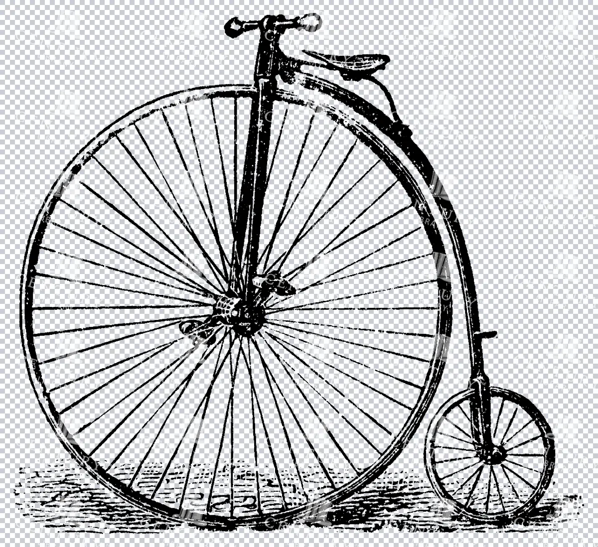
Antique Line Art Illustration of a Penny Farthing Bicycle
A vintage line art illustration of a penny farthing bicycle, showcasing its iconic large front wheel design. Ideal for transportation and historical-themed projects.
- Image Type(s): PNG
Related Images

Historical Map of Northern Michigan and Surrounding Great Lakes
A historical map of Northern Michigan, including surrounding areas of the Great Lakes, highlighting major towns, transportation routes, and natural features from the early 20th century.
- Resolution: 7164 x 5100
- Image Type(s): JPG
From this collection

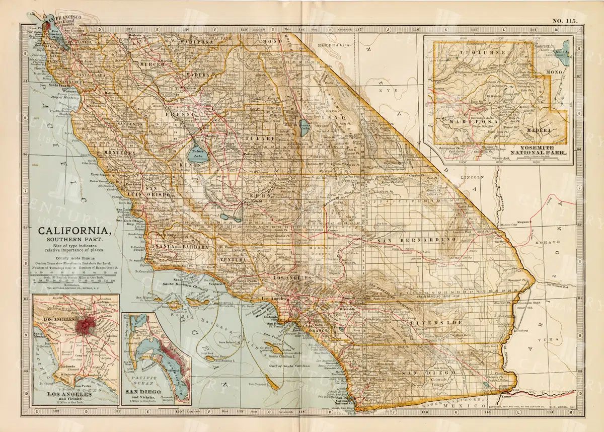
Vintage Map of Northern California Including San Francisco and Yosemite Valley
A vintage map depicting the northern part of California, highlighting major cities like San Francisco and natural landmarks such as Yosemite Valley. The map provides detailed insights into the region's geographical features, transportation routes, and historical importance.
- Resolution: 7113 x 5100
- Image Type(s): JPG
From this collection

Antique Map of Maryland and Delaware with Washington D.C.
An antique map highlighting Maryland and Delaware, including insets of Washington D.C. and Baltimore, featuring roads, rivers, and county lines from the late 19th to early 20th century.
- Resolution: 7161 x 5100
- Image Type(s): JPG
- development
- early
- 20th
- administrative
- urbanization
- 19th
- late
- county
- dc
- century
- infrastructure
- boundaries
- colonial
- cartography
- transportation
- regional
- political
- landmarks
- historic
- heritage
- urban
- Roads
- vintage
- representation
- Lines
- Antique
- History
- Washington
- Delaware
- Baltimore
- Maryland
- Geography
- Atlas
- American
- City
- World
- Rivers
- Map
- Capital
From this collection

Antique Map of Washington State
Antique map of Washington State, featuring towns, counties, railroads, and geographical features such as rivers and mountains. 19th century cartography highlighting the development and infrastructure of the state.
- Resolution: 7278 x 5100
- Image Type(s): JPG
- nostalgic
- cartographer
- state boundaries
- washington state
- state development
- historical washington
- pacific northwest
- washington map
- northwest history
- washington geography
- reference
- archival
- geographical features
- USA
- infrastructure
- railroads
- detailed map
- historical map
- exploration
- old map
- cartography
- American history
- transportation
- counties
- towns
- education
- 19th-century
- collectible
- historical
- heritage
- classic
- vintage
- representation
- Antique
- History
- Washington
- Geography
- Atlas
- World
- Rivers
- Mountains
- Map
From this collection
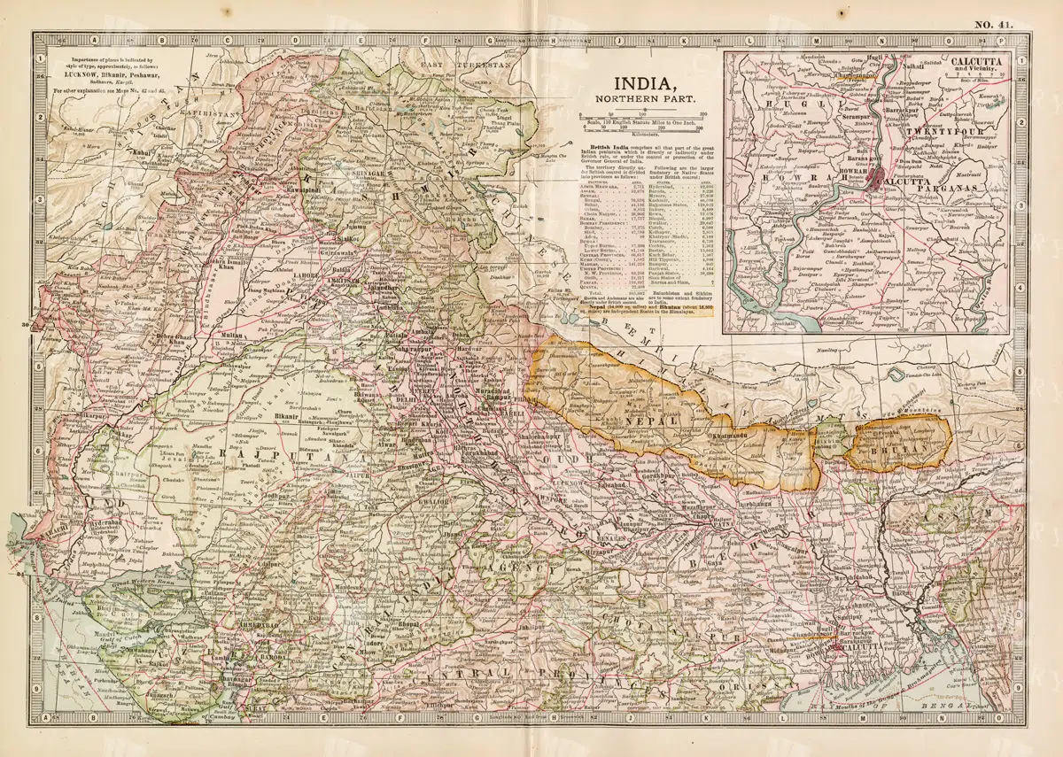
Historical Map of Northern India and Nepal Featuring Mountainous Terrain
Historical Map of Northern India and Nepal Featuring Mountainous Terrain
- Resolution: 7144 x 5100
- Image Type(s): JPG
- early 20th century
- Nepal
- Northern India
- Himalayas
- mountainous terrain
- South Asian history
- South Asia
- topography
- cities
- historical geography
- antique map
- historical map
- colonial
- exploration
- old map
- cartography
- political boundaries
- transportation
- historical
- old
- representation
- Antique
- History
- Geography
- Atlas
- World
- Landscape
- Globe
- Rivers
- Map
- Navigation
From this collection
Vintage Map of Southern California Featuring Los Angeles and San Diego
This vintage map showcases the southern part of California, including major cities like Los Angeles and San Diego. The map highlights important transportation routes, natural landmarks, and the region's historical and geographical features.
- Resolution: 7114 x 5100
- Image Type(s): JPG
From this collection

Detailed 19th Century Map of Illinois, USA
A richly detailed 19th century map of Illinois, focusing on the southern part of the state, including the area around Chicago and St. Louis. The map is intricately detailed with towns, railways, and geographical features, showcasing the state’s development during the period.
- Resolution: 7265 x 5100
- Image Type(s): JPG
- St. Louis
- southern Illinois
- archives
- reference
- territorial
- topographic
- USA
- development
- settlements
- Midwest
- topography
- antique map
- exploration
- old map
- cartography
- transportation
- railways
- counties
- landmarks
- towns
- historic
- 19th-century
- historical
- heritage
- urban
- country
- vintage
- retro
- representation
- Antique
- Rural
- History
- Chicago
- Illinois
- Geography
- Atlas
- World
- Engineering
- America
- Rivers
- Map
- Borders
From this collection

Vintage Map of Northern Illinois Featuring Chicago and Surrounding Areas
This vintage map of Northern Illinois features Chicago and its surrounding areas, highlighting major transportation routes, rivers, and urban centers. The map provides a detailed overview of the region's geography during the early 20th century, showcasing the development and expansion of Chicago as a key American city. It offers a historical perspective on the infrastructure and urban planning of the time.
- Resolution: 7142 x 5100
- Image Type(s): JPG
From this collection

Historical Map of Idaho and Wyoming Including Yellowstone National Park
This historical map covers the states of Idaho and Wyoming, with a special focus on Yellowstone National Park. The map details the topographical features, including mountains, rivers, and forests, as well as the transportation routes and political boundaries of the early 20th century. It provides a valuable snapshot of the American West during this period, highlighting the natural beauty and geographical diversity of the region.
- Resolution: 7141 x 5100
- Image Type(s): JPG
- early 20th century
- Yellowstone National Park
- Idaho
- Western states
- national parks
- forests
- topography
- historical geography
- antique map
- historical map
- exploration
- old map
- cartography
- American West
- political boundaries
- transportation
- conservation
- historical
- vintage
- old
- representation
- Antique
- History
- Wyoming
- Geography
- Landscape
- United States
- Rivers
- Mountains
- Map
From this collection

Antique Transportation Car Vehicle Line Art Isolated Illustration
A vintage line art illustration of an antique transportation car, isolated and detailed, suitable for historical and automotive-themed projects.
- Image Type(s): PNG
Related Images

Illustration of a Bactrian Camel
A vintage style illustration of a Bactrian camel with two humps, standing in a desert landscape. The artwork details the camel's thick fur and characteristic facial expression, highlighting its adaptation to harsh environments.
- Resolution: 4724px x 4308px
- Image Type(s): PNG
Related Images

Antique Map of Southern India and the Straits Settlements with Ceylon
This antique map depicts Southern India and the Straits Settlements, including the island of Ceylon (now Sri Lanka). The map highlights key cities, transportation networks, and topographical features such as rivers and mountain ranges. It provides a historical perspective on the colonial boundaries and geopolitical landscape of the region during the early 20th century, reflecting the connection between Southern India and Southeast Asia.
- Resolution: 7145 x 5100
- Image Type(s): JPG
- early 20th century
- mountain ranges
- British Empire
- colonial boundaries
- Sri Lanka
- Ceylon
- Straits Settlements
- Southern India
- South Asia
- cities
- historical geography
- antique map
- historical map
- exploration
- old map
- cartography
- transportation
- Southeast Asia
- country
- representation
- Indian Ocean
- Antique
- History
- Geography
- Atlas
- World
- Landscape
- Globe
- Rivers
- Map
- Travel
From this collection

Detailed Antique Map of Colorado Highlighting Major Cities and Geographic Features
An antique map of Colorado, showcasing major cities, counties, and detailed geographic features. The map includes railway lines, mountain ranges, and towns, providing a historical perspective on Colorado's development during the time.
- Resolution: 7120 x 5100
- Image Type(s): JPG
From this collection

Vintage Map of Connecticut and Rhode Island Including Major Cities and Coastal Features
A vintage map depicting Connecticut and Rhode Island, highlighting major cities, towns, and coastal features. The map provides detailed insights into the region's transportation routes, geographical features, and historical importance during the period.
- Resolution: 7121 x 5100
- Image Type(s): JPG
From this collection

Vintage Map of Indiana Highlighting Transportation Networks and County Borders
This vintage map of Indiana highlights the state's transportation networks, including roads and railroads, along with its county borders. The map provides a detailed view of Indiana's geography during the early 20th century, focusing on the development of infrastructure and urban areas. It offers a historical overview of the state's growth and the connections between its cities and rural areas.
- Resolution: 7146 x 5100
- Image Type(s): JPG
From this collection

Detailed Antique Map of Iowa with County Boundaries and Transportation Routes
This detailed antique map of Iowa showcases the state's county boundaries, major cities, and transportation routes, including roads and railroads. The map provides a comprehensive view of Iowa's geography during the early 20th century, highlighting the state's agricultural landscape and infrastructure development. It serves as a valuable resource for understanding Iowa's historical growth and its place in the broader Midwest.
- Resolution: 7147 x 5100
- Image Type(s): JPG
From this collection

Vintage Map of Missouri, Northern Part with Cities and Roads
A vintage map showing the northern part of Missouri, including cities, roads, and county lines, reflecting the region's infrastructure and geography from the early 20th century.
- Resolution: 7168 x 5100
- Image Type(s): JPG
From this collection

Antique Map of Mississippi with River and County Details
An antique map of Mississippi focusing on its river systems, county divisions, and major transportation routes, reflecting the state's historical geography from the early 20th century.
- Resolution: 7167 x 5100
- Image Type(s): JPG
From this collection

Antique Map of Denmark Including Copenhagen, Faroe Islands, and Iceland Inset
An antique map of Denmark featuring detailed regional boundaries, major cities like Copenhagen, and insets of the Faroe Islands and Iceland. The map offers a historical view of Denmark's geography, including transportation routes and topographical details.
- Resolution: 7122 x 5100
- Image Type(s): JPG
From this collection

Antique Map of Southern Missouri with Transportation Networks
An antique map of Southern Missouri detailing transportation networks, including railroads and highways, alongside topographical features from the early 20th century.
- Resolution: 7169 x 5100
- Image Type(s): JPG
From this collection

Support the Library
Our supporters and members help us continue collecting and restoring these wonderful pieces of art for the modern creator
Unlock Everything and Become a Member!
While a lot of the library is available for free, some is kept behind closed dusty doors only to be accessed by our lovely members.