

Vintage Map of Europe Showing Key Regions and Countries
This vintage map of Europe provides a detailed view of the continent’s countries, regions, and geographical features. The map offers a historical perspective on Europe’s political boundaries and major cities during the time period. Its detailed cartography and vintage aesthetic make it a valuable resource for historians, collectors, and anyone interested in European history. The map includes insets of various regions, adding further detail and context.
- Resolution: 7131 x 5100
- Image Type(s): JPG
- antique europe
- antique map
- Atlas
- countries
- country
- detailed europe map
- detailed map
- Europe
- europe cartography
- europe countries
- europe geography
- europe map
- europe map vintage
- europe regions
- europe vintage
- european cartography
- european cities
- european geography
- european history
- european regions
- Geography
- historical
- historical europe
- historical geography
- historical map
- Map
- old europe map
- old european map
- old map
- regions
- representation
- Travel
- vintage
- vintage cartography
- vintage europe
- World
From this collection

Antique Map of the United States
Detailed antique map of the United States showing states, territories, railroads, and cities, with inset of Alaska. Includes topographical features, rivers, and mountain ranges.
- Resolution: 7275 x 5100
- Image Type(s): JPG
- state lines
- united states map
- nostalgic
- america map
- cartographer
- reference
- archival
- USA
- topographical
- mountain ranges
- railroads
- cities
- antique map
- historical map
- territories
- exploration
- old map
- cartography
- vintage map
- American history
- transportation
- states
- historic
- education
- 19th-century
- collectible
- historical
- detailed
- heritage
- illustration
- vintage
- Atlantic Ocean
- Antique
- History
- Alaska
- Pacific Ocean
- Geography
- United States
- America
- Rivers
- Map
- Borders
From this collection

Vintage Map of Ireland Highlighting Political Boundaries and Topographical Features
This vintage map of Ireland highlights the country's political boundaries and key topographical features, including rivers, mountains, and major cities. The map provides a historical overview of Ireland during the late 19th century, offering insight into the geopolitical landscape and cultural heritage of the island. It includes detailed insets of Dublin and its surrounding areas, reflecting Ireland's rich history and complex political past.
- Resolution: 7149 x 5100
- Image Type(s): JPG
- Antique
- antique map
- Atlas
- cartography
- cities
- cultural heritage
- Dublin
- Europe
- exploration
- Geography
- geopolitical
- historical geography
- historical map
- History
- Ireland
- Ireland history
- Irish history
- Island
- Landscape
- late 19th century
- Map
- Mountains
- old map
- political boundaries
- representation
- Rivers
- topography
- United Kingdom
- vintage
- World
From this collection
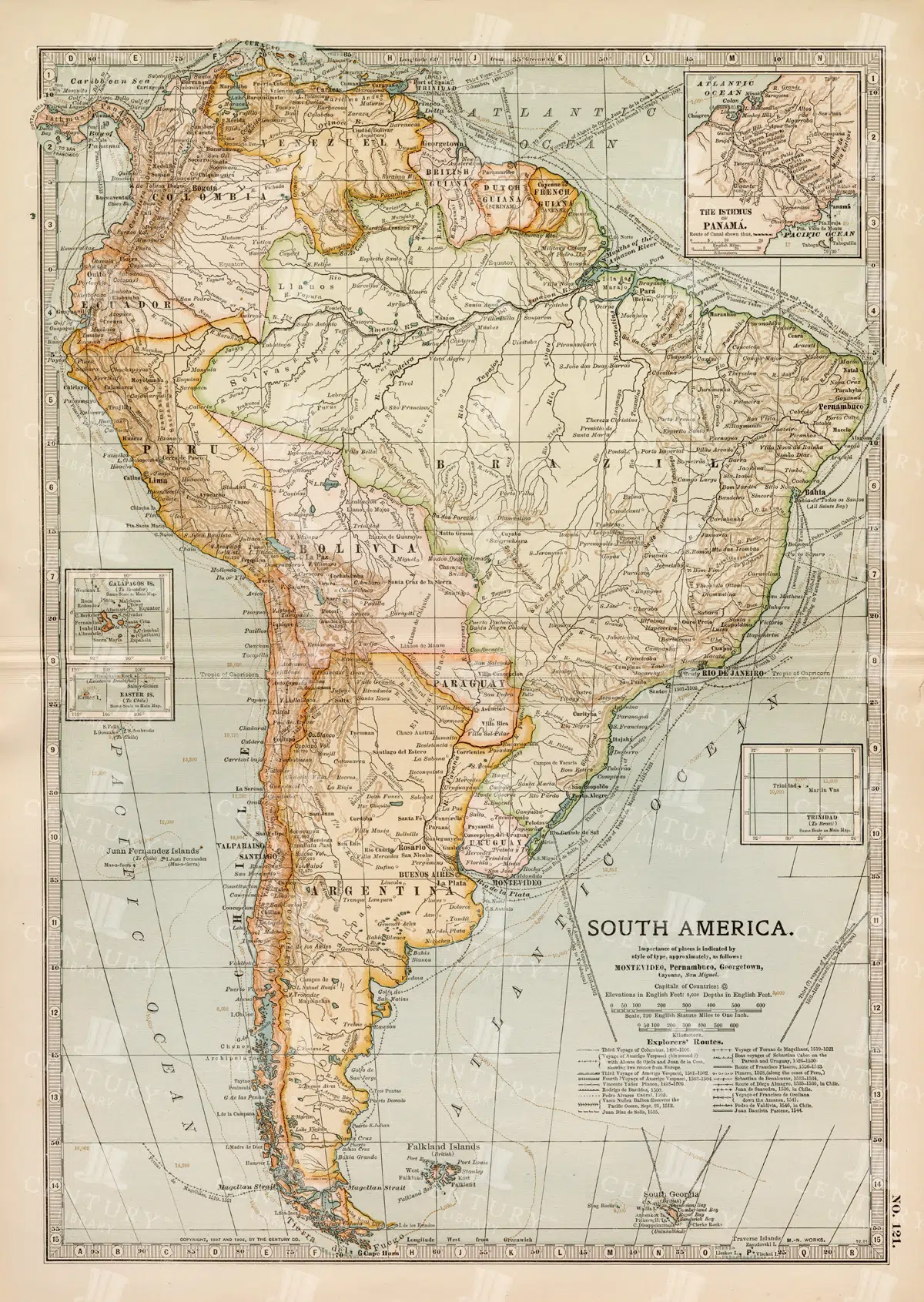
Complete 19th Century Map of South America with Geographical Details
A comprehensive 19th century map of South America, illustrating the continent's countries, cities, and geographical features in great detail. This vintage map provides an overview of the political landscape and natural features of the era.
- Resolution: 7262 x 5100
- Image Type(s): JPG
- complete map
- map of South America
- archival
- historical document
- antique cartography
- historical records
- history lovers
- historical artifact
- historical information
- antique paper
- political divisions
- geographical features
- South American history
- old South America
- Latin America
- topography
- cities
- historical geography
- antique map
- historical map
- old map
- cartography
- vintage map
- cartographic history
- 1800s
- 19th-century
- heritage
- vintage
- representation
- South America
- Geography
- Atlas
- World
- Map
From this collection

Antique Map of Florida Highlighting Key Regions and Coastal Areas
This antique map of Florida offers a detailed view of the state’s counties, cities, and coastal regions. The map provides historical insight into Florida’s geography, showcasing key areas such as Jacksonville, Tampa, and Miami. The insets offer additional detail, making this map a valuable resource for collectors and history enthusiasts. Its vintage style and detailed cartography add to its charm and historical significance.
- Resolution: 7132 x 5100
- Image Type(s): JPG
- Antique
- antique geography
- antique map
- Atlas
- cities
- coastal map
- collectible map
- counties
- detailed florida map
- detailed map
- Florida
- florida cartography
- florida coastal map
- florida geography
- florida historical map
- florida history
- florida map
- florida regions
- florida towns
- florida vintage
- Geography
- historical florida map
- historical geography
- historical map
- jacksonville
- Map
- miami
- old florida map
- old map
- regions
- representation
- southern florida
- southern states
- tampa
- vintage
- vintage cartography
- vintage florida
- World
From this collection

Vintage 1800s Map of Alaska Featuring Detailed Geography and Historical Boundaries – Antique Historical Map
An antique map from the 1800s featuring Alaska, highlighting its detailed geography and historical boundaries. This vintage map offers a glimpse into the early cartographic representation of Alaska, with intricate details of its natural features and political divisions. A perfect addition for those interested in Alaskan history and vintage maps.
- Resolution: 7105 x 5100
- Image Type(s): JPG
From this collection
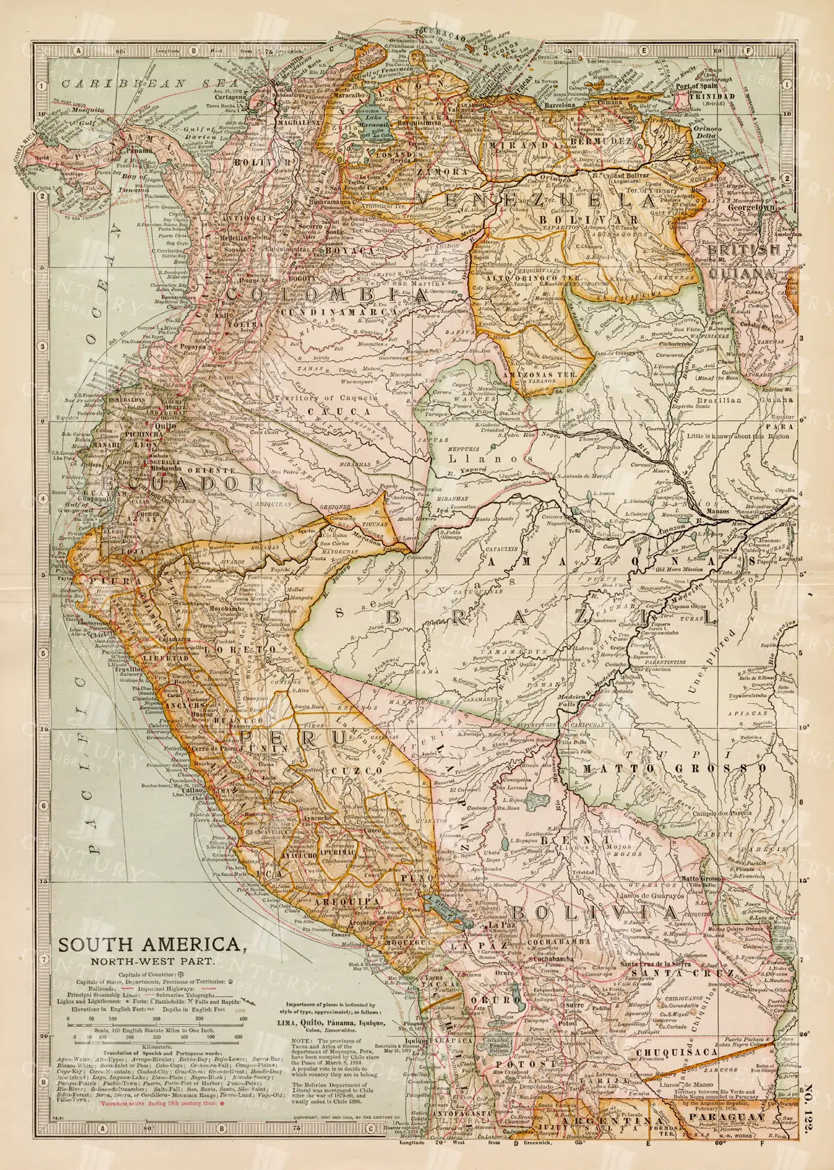
Detailed 19th Century Map of Northwestern South America
A detailed 19th century map illustrating the northwestern part of South America, including countries like Colombia, Venezuela, and Ecuador. This vintage map offers a glimpse into the political and geographical divisions of the era, with detailed insets of major cities and regions.
- Resolution: 7260 x 5100
- Image Type(s): JPG
- archival
- historical document
- antique cartography
- historical records
- history lovers
- historical artifact
- historical information
- antique paper
- political divisions
- geographical features
- South American history
- old South America
- Latin America
- Northwestern South America
- Colombia
- Venezuela
- map of Colombia
- topography
- cities
- historical geography
- antique map
- historical map
- old map
- cartography
- vintage map
- cartographic history
- 1800s
- 19th-century
- heritage
- country
- vintage
- representation
- Antique
- Ecuador
- South America
- Geography
- Atlas
- World
- Globe
- Map
- Travel
- Navigation
From this collection
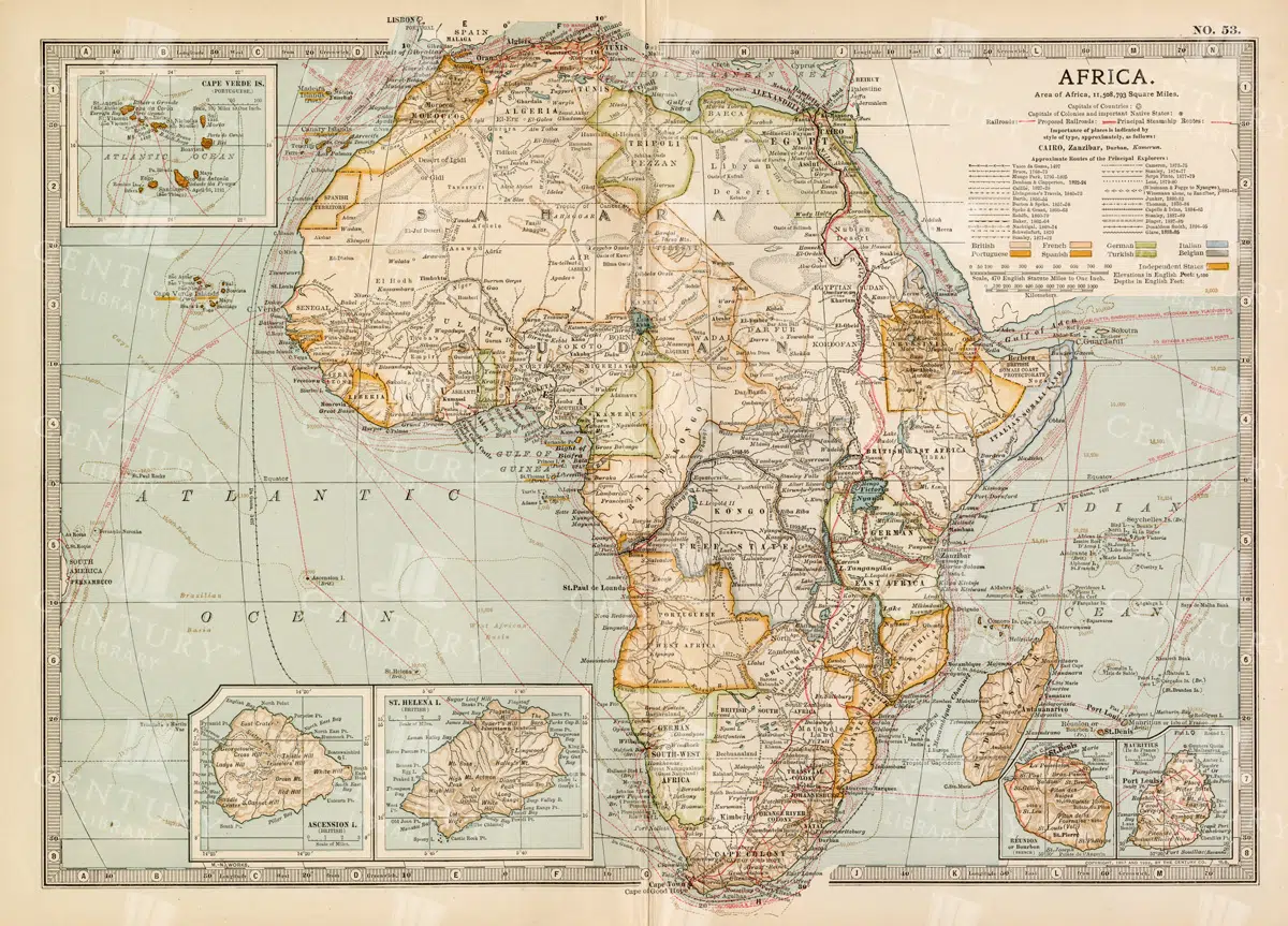
Antique 1800s Map of Africa Showing Entire Continent and Colonial Territories – Vintage Historical Cartography
This comprehensive antique map from the 1800s showcases the entire continent of Africa, highlighting colonial territories and geographical features. The map is a valuable historical document, offering insights into Africa's political and natural landscape during the colonial era. A beautifully detailed piece of vintage cartography.
- Resolution: 7104 x 5100
- Image Type(s): JPG
- 1800s
- Africa
- Africa colonial
- Africa history
- Africa map
- Antique
- antique map
- Atlas
- boundaries
- cartography
- colonial era
- colonial territories
- country
- detailed
- entire continent
- exploration
- Geography
- historical
- historical map
- History
- illustration
- Map
- natural features
- old map
- political map
- preserved
- representation
- retro
- topography
- vintage
- vintage map
- World
From this collection

Antique Map of the West Indies
Historical antique map of the West Indies, showcasing islands like Cuba, Jamaica, and Puerto Rico, with detailed nautical routes, ports, and topography. Includes inset of Bermuda. 19th century cartography.
- Resolution: 7279 x 5100
- Image Type(s): JPG
- nostalgic
- cartographer
- cuba
- puerto rico
- nautical routes
- ports
- bermuda
- islands map
- sea routes
- bermuda map
- west indies map
- island history
- archival
- Caribbean islands
- Caribbean
- detailed map
- maritime
- topography
- historical map
- exploration
- old map
- cartography
- transportation
- 19th-century
- collectible
- historical
- heritage
- classic
- Islands
- country
- vintage
- representation
- Atlantic Ocean
- Antique
- History
- Jamaica
- West Indies
- Geography
- Atlas
- World
- Map
- Nautical
From this collection

Antique Map of Northern France Including the English Channel and Paris
This antique map of Northern France illustrates the region’s towns, roads, and geographical features, including Paris and the English Channel. The map provides a detailed representation of the historical geography of the area, showing the connections between key locations. Its vintage aesthetic adds charm, making it a must-have for history enthusiasts and map collectors. Insets highlight additional regions, enhancing the map's utility and appeal.
- Resolution: 7134 x 5100
- Image Type(s): JPG
- english channel map
- northern france
- english channel
- paris geography
- old france map
- france vintage
- french cartography
- france towns
- france regions
- french history
- detailed map
- vintage cartography
- french geography
- historical france map
- vintage france
- france cartography
- french map
- france history
- paris map
- historical geography
- antique map
- historical map
- old map
- northern
- towns
- historical
- Roads
- vintage
- representation
- Paris
- Geography
- Atlas
- World
- France
- Map
From this collection

Historical Map of North-Central France Including the Vicinity of Paris
This historical map of North-Central France features detailed depictions of towns, roads, and geographical features surrounding Paris. It showcases the intricate layout of the region, making it an invaluable resource for historians and map enthusiasts. The vintage style and precise detailing provide insight into the historical geography of France during the period, highlighting key locations and the relationship between Paris and its surrounding areas.
- Resolution: 7133 x 5100
- Image Type(s): JPG
- paris geography
- vintage france map
- old france map
- france vintage
- french cartography
- france towns
- france regions
- french history
- detailed map
- vintage cartography
- french geography
- north-central
- historical france map
- vintage france
- france cartography
- french map
- paris vicinity
- north-central france
- france history
- france geography
- paris map
- historical france
- historical geography
- antique map
- historical map
- old map
- towns
- historical
- Roads
- brass
- vintage
- representation
- Paris
- Geography
- France
- Map
From this collection

Vintage 1800s Map of Asia with Emphasis on Siberia and Central Asia – Antique Historical Map
A vintage map from the 1800s featuring Asia, with special emphasis on Siberia and Central Asia. The antique map showcases the vast geography, political boundaries, and natural features of the region, offering a detailed view of Asia during the 19th century. Perfect for those interested in Asian history and vintage cartography.
- Resolution: 7109 x 5100
- Image Type(s): JPG
From this collection

19th Century Map of Southern South America Featuring Argentina and Chile
A richly detailed 19th century map of Southern South America, highlighting countries like Argentina and Chile, with special insets of Buenos Aires, Montevideo, and Valparaiso. This vintage map showcases the region's political and geographical landscape during the era.
- Resolution: 7261 x 5100
- Image Type(s): JPG
- 1800s
- 19th-century
- antique cartography
- antique map
- antique paper
- archival
- Argentina
- Atlas
- Buenos Aires
- cartographic history
- cartography
- Chile
- cities
- geographical features
- Geography
- heritage
- historical artifact
- historical document
- historical geography
- historical information
- historical map
- historical records
- history lovers
- Latin America
- Map
- map of Argentina
- Montevideo
- old map
- old South America
- political divisions
- representation
- South America
- South American history
- Southern South America
- topography
- Valparaiso
- vintage
- vintage map
- World
From this collection

Antique Map of Georgia Highlighting Counties, Cities, and Key Regions
This antique map of Georgia offers a detailed view of the state, showcasing its counties, major cities, and key geographical features. The map provides a historical perspective on Georgia’s landscape, from its northern mountains to its southern coast. Insets focus on specific areas like Savannah and Chickamauga National Park, providing additional context and detail. This map is perfect for history buffs and collectors.
- Resolution: 7136 x 5100
- Image Type(s): JPG
- Antique
- antique geography
- antique map
- Atlas
- chickamauga national park
- cities
- collectible map
- counties
- detailed georgia map
- detailed map
- Geography
- Georgia
- georgia cartography
- georgia geography
- georgia historical map
- georgia history
- georgia landscape
- georgia map
- georgia regions
- georgia towns
- georgia vintage
- historical
- historical geography
- historical georgia map
- historical map
- Map
- old
- old georgia map
- old map
- regions
- representation
- Savannah
- southern georgia
- southern states
- vintage
- vintage cartography
- vintage georgia
From this collection

Antique Map of Vermont and New Hampshire
Detailed antique map showing the states of Vermont and New Hampshire with towns, railroads, rivers, and geographical features. Historical cartography showcasing 19th century state boundaries and infrastructures.
- Resolution: 7276 x 5100
- Image Type(s): JPG
- state lines
- nostalgic
- cartographer
- state boundaries
- infrastructures
- vermont map
- new hampshire map
- reference
- archival
- geographical features
- USA
- railroads
- detailed map
- historical map
- exploration
- old map
- cartography
- vintage map
- American history
- transportation
- states
- towns
- historic
- education
- 19th-century
- collectible
- historical
- heritage
- classic
- vintage
- representation
- Atlantic Ocean
- Antique
- History
- New England
- Vermont
- New Hampshire
- Geography
- Atlas
- Rivers
- Map
- Borders
From this collection

Antique Map of Virginia
Historical antique map of Virginia, showing counties, towns, railroads, rivers, and geographical details. Includes insets of the western part of Virginia and the Norfolk vicinity. 19th century cartography.
- Resolution: 7277 x 5100
- Image Type(s): JPG
- nostalgic
- cartographer
- state boundaries
- geographical details
- virginia map
- western virginia
- norfolk
- virginia counties
- historical regions
- reference
- archival
- USA
- railroads
- detailed map
- historical map
- exploration
- old map
- cartography
- American history
- transportation
- counties
- towns
- historic
- education
- 19th-century
- collectible
- historical
- heritage
- classic
- vintage
- old
- representation
- Atlantic Ocean
- Antique
- History
- Virginia
- Geography
- Atlas
- Rivers
- Map
From this collection

19th Century Central Scotland Map Featuring Glasgow and Edinburgh
A vintage map from the 19th century depicting central Scotland, highlighting major cities like Glasgow and Edinburgh. This historical map is rich in detail, showcasing the region's topography, transportation routes, and geographical features during the era.
- Resolution: 7258 x 5100
- Image Type(s): JPG
- archival
- historical document
- antique cartography
- historical records
- history lovers
- historical artifact
- historical information
- antique paper
- geographical features
- central Scotland
- Glasgow
- map of Scotland
- Scottish history
- old Britain
- Scottish Highlands
- Lowlands
- transportation routes
- topography
- cities
- historical geography
- antique map
- historical map
- old map
- cartography
- vintage map
- cartographic history
- 1800s
- 19th-century
- heritage
- Edinburgh
- vintage
- representation
- British History
- Geography
- Atlas
- World
- Map
- United Kingdom
- Scotland
From this collection

Antique 1800s Map of North-West Africa Highlighting Morocco, Algeria, and Western Sahara – Vintage Historical Map
This antique map from the 1800s highlights North-West Africa, including Morocco, Algeria, and the Western Sahara. It captures the colonial and geographical landscape of the time, showing intricate details of the region’s political boundaries and natural features. A beautifully preserved piece of history in vintage cartography.
- Resolution: 7102 x 5100
- Image Type(s): JPG
- 1800s
- Africa
- Africa colonial
- Africa map
- Algeria
- Antique
- antique map
- Atlas
- cartography
- colonial
- colonial era
- country
- detailed
- exploration
- Geography
- Globe
- historical
- historical map
- History
- Map
- Morocco
- natural features
- Navigation
- North-West Africa
- old
- old map
- political boundaries
- preserved
- representation
- retro
- topography
- Travel
- vintage
- vintage map
- Western Sahara
- World
From this collection

Antique Map of Eastern India, Burma, Siam, and French Indo-China
This antique map showcases Eastern India, Burma (now Myanmar), Siam (now Thailand), and French Indo-China (Vietnam, Laos, Cambodia), with a focus on the geopolitical boundaries and major cities of the early 20th century. The map provides a detailed view of the region's topographical features, including rivers, mountain ranges, and coastlines, reflecting the historical context of Southeast Asia during this period.
- Resolution: 7143 x 5100
- Image Type(s): JPG
- Antique
- antique map
- Asia
- Atlas
- Burma
- cartography
- cities
- coastlines
- colonial
- country
- cultural heritage
- early 20th century
- Eastern India
- exploration
- French Indo-China
- Geography
- geopolitical boundaries
- historical geography
- historical map
- History
- Landscape
- Map
- mountain ranges
- old map
- representation
- Rivers
- Siam
- Southeast Asia
- topography
- World
From this collection

Historical Map of Cornwall, Devonshire, Dorset, and the Channel Islands
This historical map showcases the regions of Cornwall, Devonshire, Dorset, and the Channel Islands, detailing their towns, roads, and coastal features. The map is an essential resource for those interested in the historical geography of southern England. The vintage style and detailed cartography offer a unique insight into the area’s past, making it a valuable piece for collectors and history enthusiasts alike.
- Resolution: 7130 x 5100
- Image Type(s): JPG
- vintage england
- british geography
- england history
- dorset map
- devonshire map
- cornwall map
- southern england
- channel islands
- dorset
- devonshire
- english cartography
- detailed map
- english geography
- channel islands map
- vintage british map
- southern england map
- british vintage
- old england map
- coastal map
- england regions
- vintage cartography
- cornwall
- historical geography
- antique map
- historical map
- old map
- towns
- historical
- Roads
- vintage
- representation
- British History
- Geography
- Atlas
- World
- Map
From this collection

Antique Map of West Virginia
Detailed antique map of West Virginia, showing counties, towns, railroads, and geographical features. Historical 19th century cartography with insets of surrounding areas. An educational and collectible piece.
- Resolution: 7280 x 5100
- Image Type(s): JPG
- nostalgic
- cartographer
- state boundaries
- historical regions
- west virginia map
- west virginia counties
- surrounding areas
- heritage map
- vintage west virginia
- state map
- reference
- archival
- geographical features
- USA
- railroads
- detailed map
- topography
- historical map
- exploration
- old map
- cartography
- American history
- transportation
- counties
- towns
- education
- 19th-century
- collectible
- historical
- heritage
- classic
- vintage
- old
- representation
- Antique
- History
- West Virginia
- Geography
- Atlas
- World
- Globe
- Map
From this collection

Vintage 1800s Map of Southern Africa Including South Africa, Namibia, and Surrounding Territories – Antique Map
A vintage map from the 1800s depicting Southern Africa, including South Africa, Namibia, and surrounding territories. This antique map highlights the region’s colonial borders, cities, and natural features, offering a detailed view of the area during the colonial period. Perfect for history and cartography enthusiasts.
- Resolution: 7103 x 5100
- Image Type(s): JPG
From this collection
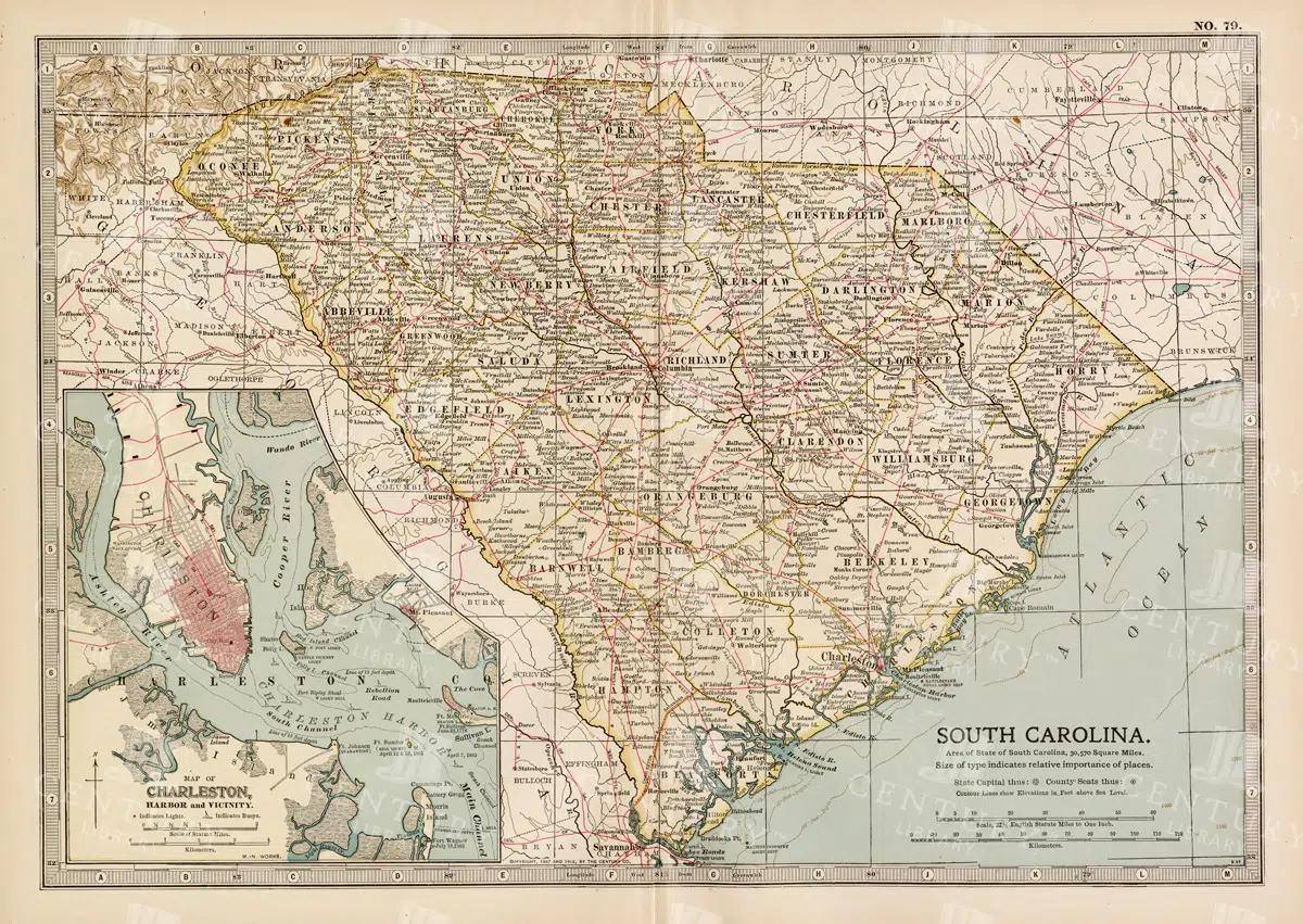
19th Century South Carolina Map with Charleston Harbor Inset
A detailed 19th century map of South Carolina, featuring an inset of Charleston Harbor. This vintage map provides a glimpse into the state's political and geographical landscape during the era, highlighting cities, transportation routes, and natural features.
- Resolution: 7263 x 5100
- Image Type(s): JPG
- South Carolina
- Charleston Harbor
- map of South Carolina
- old South Carolina
- Charleston history
- archival
- historical document
- antique cartography
- historical records
- history lovers
- historical artifact
- historical information
- antique paper
- political divisions
- geographical features
- topography
- cities
- historical geography
- antique map
- historical map
- old map
- cartography
- vintage map
- American history
- cartographic history
- 1800s
- 19th-century
- heritage
- country
- vintage
- representation
- Geography
- Atlas
- World
- United States
- Map
From this collection
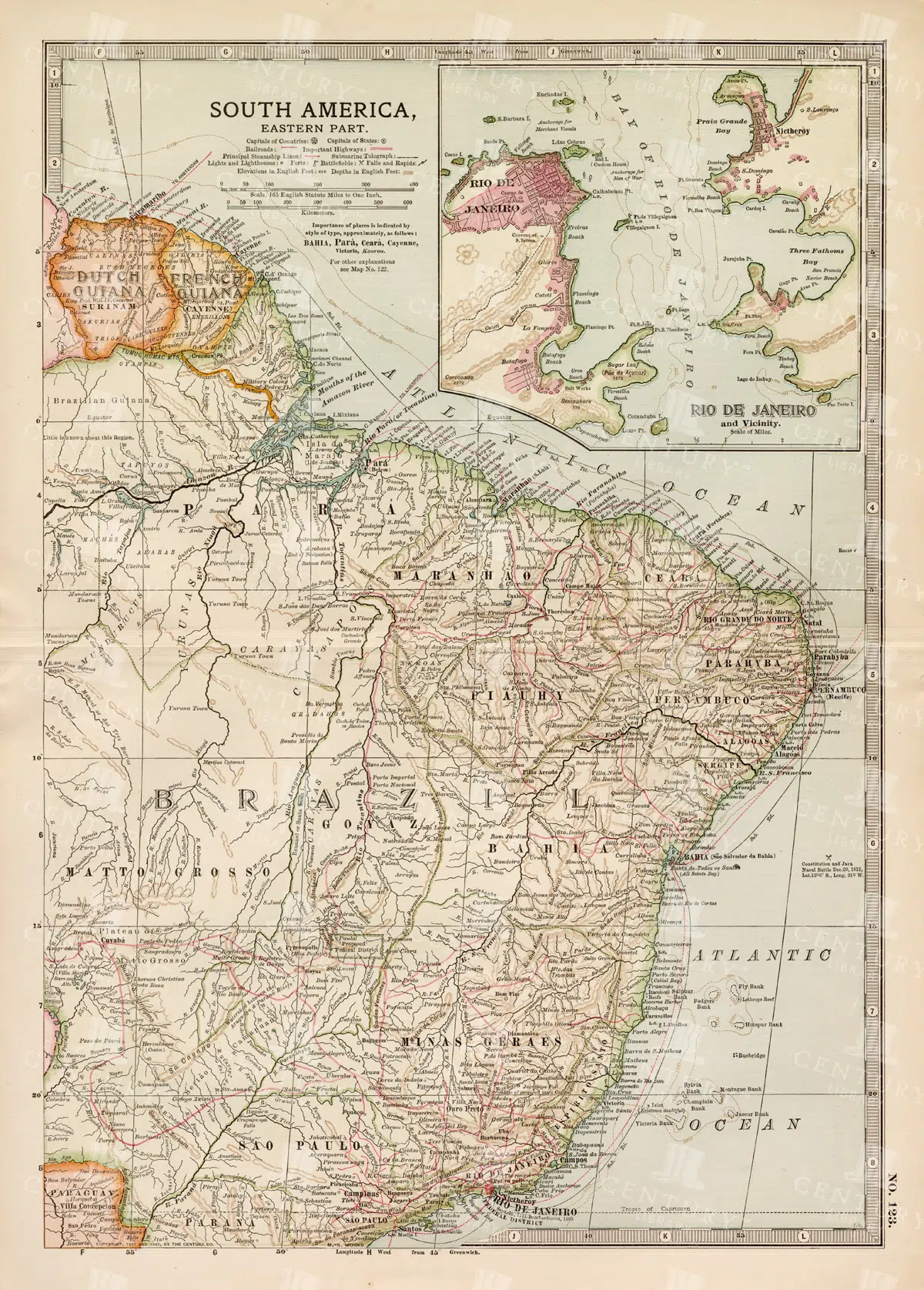
19th Century Map of Eastern South America Including Rio de Janeiro
A detailed 19th century map of Eastern South America, focusing on countries like Brazil, French Guiana, and others, with a special inset of Rio de Janeiro. This vintage map illustrates the political and geographical landscape of the time, with precise details of cities and natural features.
- Resolution: 7259 x 5100
- Image Type(s): JPG
- 1800s
- 19th-century
- antique cartography
- antique map
- antique paper
- archival
- Atlas
- Brazil
- cartographic history
- cartography
- cities
- Eastern South America
- French Guiana
- geographical features
- Geography
- heritage
- historical artifact
- historical document
- historical geography
- historical information
- historical map
- historical records
- history lovers
- Latin America
- Map
- map of Brazil
- old map
- old South America
- political divisions
- representation
- Rio de Janeiro
- South America
- South American history
- topography
- vintage
- vintage map
- World
From this collection
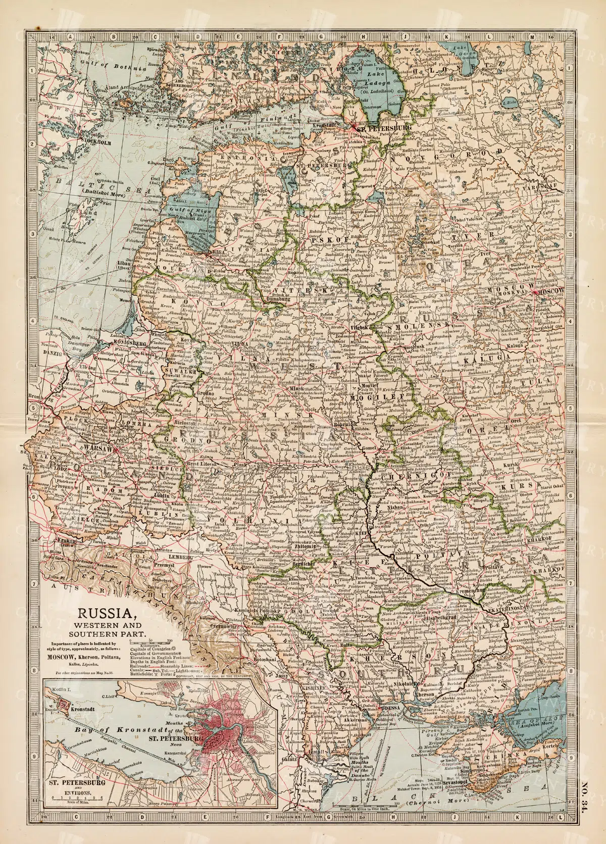
19th Century Map of Russia’s Western and Southern Parts with St. Petersburg
A detailed 19th century map highlighting the western and southern parts of Russia, including the prominent city of St. Petersburg. This vintage map showcases the political and geographical landscape of the era, featuring intricate details of cities, rivers, and borders.
- Resolution: 7257 x 5100
- Image Type(s): JPG
- 1800s
- 19th-century
- Antique
- antique cartography
- antique map
- antique paper
- archival
- Atlas
- Baltic Sea
- cartographic history
- cartography
- cities
- Eastern Europe
- european history
- geographical features
- Geography
- heritage
- historical artifact
- historical document
- historical geography
- historical information
- historical map
- historical records
- history lovers
- Map
- map of Russia
- old
- old Europe
- old map
- political divisions
- representation
- Rivers
- Russia
- Russian Empire
- southern Russia
- St. Petersburg
- St. Petersburg history
- topography
- vintage
- vintage map
- western Russia
From this collection
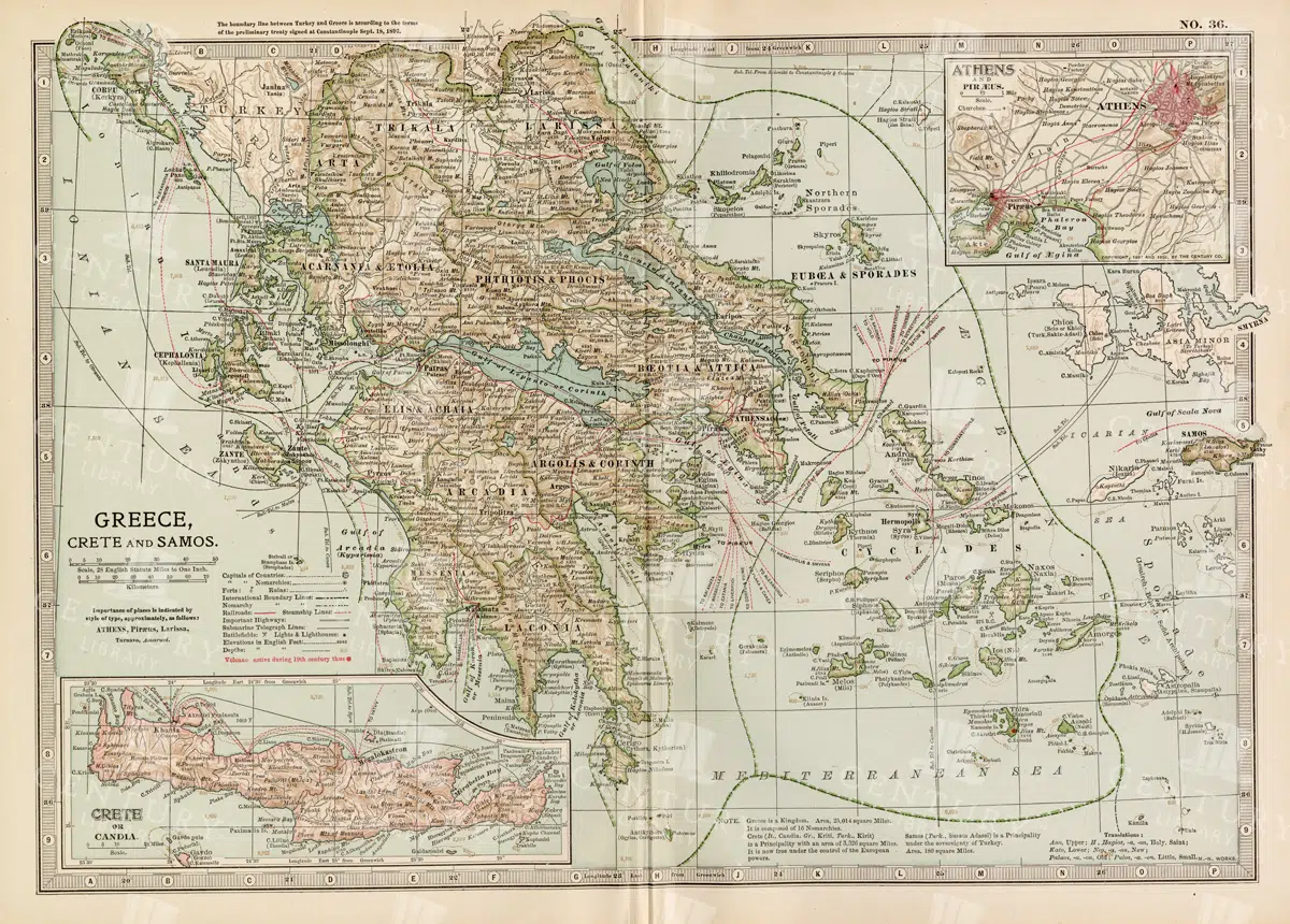
Antique Map of Greece Highlighting Crete and Samos with Detailed Topography
This antique map of Greece highlights the regions of Crete and Samos, showing detailed topographical features such as mountains, rivers, and coastlines. The map provides a historical overview of the geopolitical boundaries, major cities, and maritime routes in the Aegean Sea during the late 19th century. It offers a valuable perspective on the landscape and political divisions of Greece and its islands at the time.
- Resolution: 7140 x 5100
- Image Type(s): JPG
From this collection

Historical Map of the Eastern Part of the German Empire
This historical map of the eastern part of the German Empire showcases its towns, roads, and geographical features in great detail. The map offers a glimpse into the region’s past, highlighting key cities like Berlin and Hamburg. Insets provide additional details about these major cities, making the map an essential resource for historians and collectors interested in German history and cartography.
- Resolution: 7137 x 5100
- Image Type(s): JPG
- Antique
- antique geography
- antique map
- Atlas
- Berlin
- berlin map
- detailed german map
- detailed map
- Eastern
- eastern german map
- eastern germany
- Geography
- german cartography
- german cities
- german empire
- german empire map
- german geography
- german history
- german regions
- german towns
- german vintage
- hamburg
- hamburg map
- historical
- historical geography
- historical german map
- historical germany map
- historical map
- Map
- old germany map
- old map
- representation
- Roads
- towns
- vintage
- vintage cartography
- vintage germany
- World
From this collection

Antique Map of Wisconsin
Historical antique map of Wisconsin, showing counties, towns, railroads, rivers, and other geographical features. A 19th century map that illustrates the development and infrastructure of the state.
- Resolution: 7281 x 5100
- Image Type(s): JPG
- nostalgic
- cartographer
- state boundaries
- historical regions
- heritage map
- wisconsin map
- wisconsin counties
- vintage wisconsin
- historical development
- state map
- reference
- geographical features
- USA
- infrastructure
- railroads
- detailed map
- topography
- historical map
- exploration
- old map
- cartography
- American history
- transportation
- counties
- towns
- education
- 19th-century
- collectible
- historical
- heritage
- classic
- vintage
- representation
- Antique
- History
- Wisconsin
- Geography
- Atlas
- World
- Rivers
- Map
From this collection

19th Century Russia in Europe with Poland and Finland Vintage Map
A detailed 19th century map depicting Russia in Europe, including Poland and Finland. This historical artifact provides insight into the territorial boundaries and political divisions of the time, with intricate detailing of cities, rivers, and topographical features.
- Resolution: 7256 x 5100
- Image Type(s): JPG
- 1800s
- 19th-century
- Antique
- antique cartography
- antique map
- antique paper
- archival
- Atlas
- Baltic Sea
- Black Sea
- cartographic history
- cartography
- cities
- Eastern Europe
- european history
- Finland
- Finland history
- Geography
- heritage
- historical artifact
- historical document
- historical geography
- historical information
- historical map
- historical records
- history lovers
- Map
- map of Russia
- old Europe
- old map
- Poland
- Poland history
- political divisions
- representation
- Rivers
- Russia in Europe
- Russian Empire
- territorial boundaries
- topography
- vintage
- vintage map
- World
From this collection
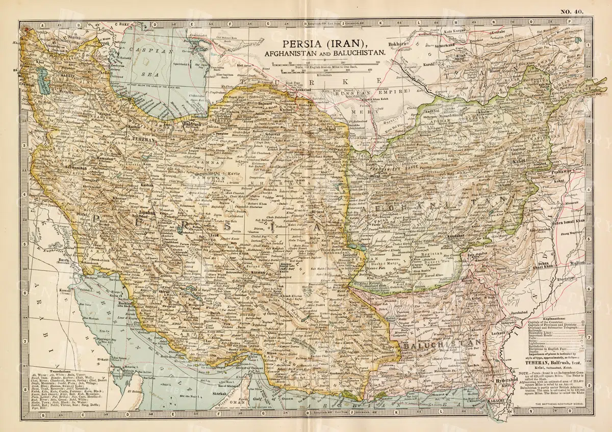
Antique Map of Persia, Afghanistan, and Baluchistan with Geopolitical Borders
This antique map of Persia (modern-day Iran), Afghanistan, and Baluchistan highlights the geopolitical borders and key cities of the early 20th century. The map details the region's topographical features, including mountain ranges, rivers, and deserts, offering a comprehensive view of the landscape. It provides a historical perspective on the political and geographical divisions in this part of the Middle East and South Asia during the period.
- Resolution: 7148 x 5100
- Image Type(s): JPG
- Afghanistan
- Afghanistan history
- Antique
- antique map
- Atlas
- Baluchistan
- cartography
- cities
- colonial
- country
- deserts
- early 20th century
- exploration
- Geography
- geopolitical borders
- historical geography
- historical map
- History
- Iran
- Landscape
- Map
- Middle East
- mountain ranges
- old map
- Persia
- Persia history
- representation
- Rivers
- South Asia
- topography
- World
From this collection

Vintage Map of the Southwestern Part of the German Empire with Regional Details
This vintage map of the southwestern part of the German Empire details the region’s cities, roads, and geographical features. The map provides a historical overview of the area, including key locations like Munich and Stuttgart. The vintage style and precise detailing make it an essential resource for those interested in the history and geography of this region. The map also includes insets of specific cities, offering additional insight into the urban development of the time.
- Resolution: 7139 x 5100
- Image Type(s): JPG
- historical german map
- detailed german map
- old germany map
- german vintage
- german towns
- german regions
- historical germany map
- german cities
- vintage germany
- german geography
- southwestern
- munich
- southwestern german map
- southwestern germany
- stuttgart map
- munich map
- stuttgart
- german empire map
- german cartography
- german history
- german empire
- detailed map
- vintage cartography
- antique geography
- historical geography
- antique map
- historical map
- old map
- towns
- historical
- Roads
- vintage
- old
- representation
- Antique
- Geography
- Atlas
- World
- Map
From this collection

Detailed Map of the Northern Part of the German Empire with Key Cities
This detailed map of the northern part of the German Empire highlights key cities such as Hamburg and Berlin, along with roads and geographical features. The map offers a historical perspective on the region's landscape and its urban development during the time period. Its vintage style and detailed cartography make it an invaluable resource for collectors and history enthusiasts. The map’s detailed depiction of the area’s geography is a window into the past.
- Resolution: 7138 x 5100
- Image Type(s): JPG
- Antique
- antique geography
- antique map
- Atlas
- Berlin
- berlin map
- detailed german map
- detailed map
- Geography
- german cartography
- german cities
- german empire
- german empire map
- german geography
- german history
- german regions
- german towns
- german vintage
- hamburg
- hamburg map
- historical
- historical geography
- historical german map
- historical germany map
- historical map
- Map
- northern
- northern german map
- northern germany
- old germany map
- old map
- representation
- Roads
- towns
- vintage
- vintage cartography
- vintage germany
- World
From this collection
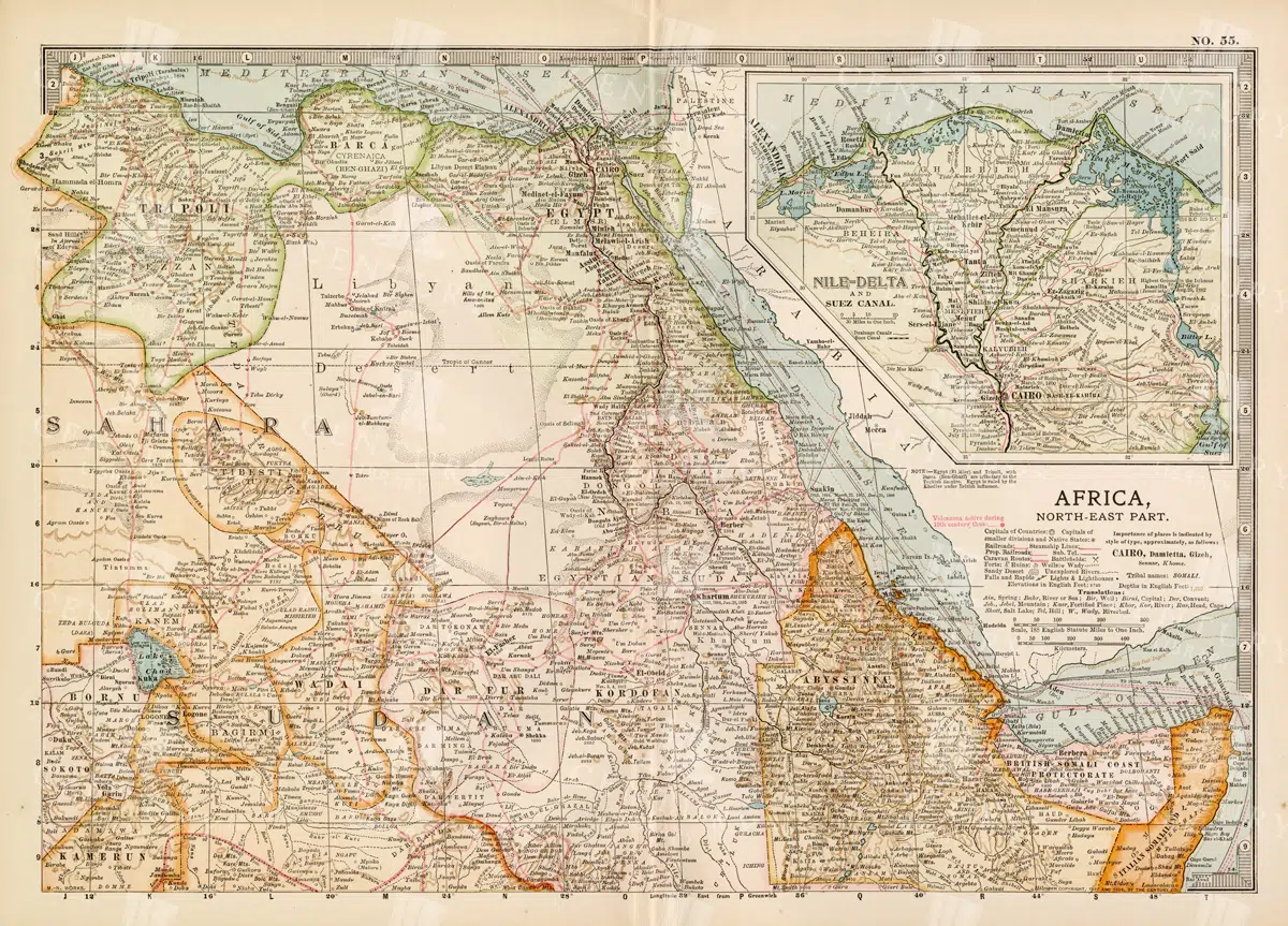
Vintage 1800s Map of North-East Africa Including Egypt, Sudan, and the Nile Delta – Antique Historical Map
This vintage map from the 1800s illustrates North-East Africa, including Egypt, Sudan, and the Nile Delta. The map is a beautiful representation of the region's historical geography, showing important cities, boundaries, and geographical features from the colonial era. A valuable piece for those interested in African history and cartography.
- Resolution: 7101 x 5100
- Image Type(s): JPG
- 1800s
- Africa
- Africa colonial
- Africa map
- Antique
- antique map
- Atlas
- boundaries
- cartography
- cities
- colonial era
- detailed
- Egypt
- exploration
- Geography
- historical
- historical geography
- historical map
- illustration
- Map
- Nile Delta
- North-East Africa
- old map
- preserved
- representation
- retro
- Rivers
- Sudan
- topography
- Travel
- vintage
- vintage map
- World
From this collection

Vintage Map of Southern France Featuring Marseille and the Mediterranean Coast
This vintage map of Southern France details the region’s towns, roads, and geographical features, with a particular focus on Marseille and the Mediterranean coast. The map provides a comprehensive look at the area’s historical geography, making it a valuable addition for collectors and history enthusiasts. The insets offer additional details about Marseille and surrounding areas, enhancing the map's appeal and utility.
- Resolution: 7135 x 5100
- Image Type(s): JPG
- Antique
- antique map
- Atlas
- country
- detailed map
- France
- france cartography
- france history
- france regions
- france towns
- france vintage
- french geography
- french history
- french map
- Geography
- Globe
- historical
- historical france map
- historical geography
- historical map
- Map
- marseille
- marseille geography
- marseille map
- Mediterranean
- mediterranean coast
- mediterranean map
- old france map
- old map
- representation
- Roads
- southern
- southern france
- towns
- Travel
- vintage
- vintage cartography
- vintage france
- World
From this collection

Antique 1800s Map of Arabia, Oman, and Aden Including the Arabian Peninsula – Vintage Historical Map
This antique map from the 1800s illustrates the Arabian Peninsula, including Arabia, Oman, and Aden. The vintage map highlights the region's historical geography, boundaries, and important cities, offering a detailed view of the area during the colonial period. A valuable resource for those interested in Middle Eastern history and cartography.
- Resolution: 7106 x 5100
- Image Type(s): JPG
From this collection

Antique 1800s Map of Arkansas with Detailed County Lines and Natural Features – Vintage Historical Cartography
An antique map from the 1800s showcasing Arkansas, with detailed county lines and natural features. This vintage map provides a historical view of Arkansas’s geography during the 19th century, offering a beautifully preserved piece of the state’s cartographic history.
- Resolution: 7108 x 5100
- Image Type(s): JPG
From this collection

Antique Map of Washington State
Antique map of Washington State, featuring towns, counties, railroads, and geographical features such as rivers and mountains. 19th century cartography highlighting the development and infrastructure of the state.
- Resolution: 7278 x 5100
- Image Type(s): JPG
- nostalgic
- cartographer
- state boundaries
- washington state
- state development
- historical washington
- pacific northwest
- washington map
- northwest history
- washington geography
- reference
- archival
- geographical features
- USA
- infrastructure
- railroads
- detailed map
- historical map
- exploration
- old map
- cartography
- American history
- transportation
- counties
- towns
- education
- 19th-century
- collectible
- historical
- heritage
- classic
- vintage
- representation
- Antique
- History
- Washington
- Geography
- Atlas
- World
- Rivers
- Mountains
- Map
From this collection

Detailed 19th Century Map of Quebec, Canada with Historical Context
A richly detailed 19th century map of Quebec, Canada, showcasing various regions, cities, and geographical features. This historical map provides a glimpse into the past, reflecting the administrative and territorial divisions of the era. Insets highlight key areas, enhancing the map's informative value.
- Resolution: 7255 x 5100
- Image Type(s): JPG
- historical context
- Canadian history
- territorial divisions
- map insets
- archival
- historical document
- geography of Quebec
- Canadian provinces
- antique cartography
- St. Lawrence River
- historical records
- old Quebec
- history lovers
- historical artifact
- map of Canada
- historical information
- Quebec history
- antique paper
- educational tool
- detailed map
- regions
- topography
- cities
- historical geography
- antique map
- historical map
- old map
- cartography
- vintage map
- cartographic history
- 1800s
- 19th-century
- heritage
- country
- vintage
- representation
- Montreal
- Quebec
- Geography
- Atlas
- World
- Canada
- North America
- Map
From this collection
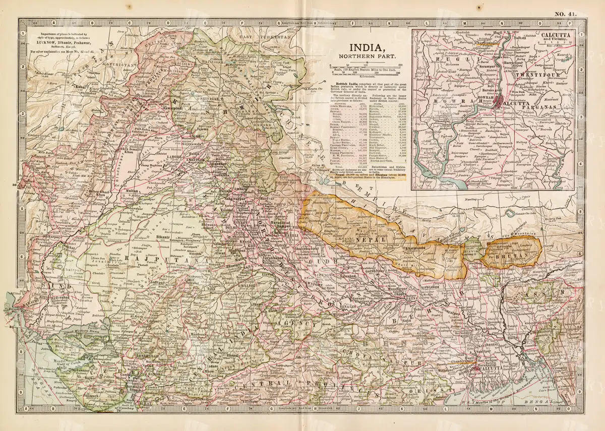
Historical Map of Northern India and Nepal Featuring Mountainous Terrain
Historical Map of Northern India and Nepal Featuring Mountainous Terrain
- Resolution: 7144 x 5100
- Image Type(s): JPG
- early 20th century
- Nepal
- Northern India
- Himalayas
- mountainous terrain
- South Asian history
- South Asia
- topography
- cities
- historical geography
- antique map
- historical map
- colonial
- exploration
- old map
- cartography
- political boundaries
- transportation
- historical
- old
- representation
- Antique
- History
- Geography
- Atlas
- World
- Landscape
- Globe
- Rivers
- Map
- Navigation
From this collection

Vintage Map of Northern Illinois Featuring Chicago and Surrounding Areas
This vintage map of Northern Illinois features Chicago and its surrounding areas, highlighting major transportation routes, rivers, and urban centers. The map provides a detailed overview of the region's geography during the early 20th century, showcasing the development and expansion of Chicago as a key American city. It offers a historical perspective on the infrastructure and urban planning of the time.
- Resolution: 7142 x 5100
- Image Type(s): JPG
From this collection

Historical Map of Idaho and Wyoming Including Yellowstone National Park
This historical map covers the states of Idaho and Wyoming, with a special focus on Yellowstone National Park. The map details the topographical features, including mountains, rivers, and forests, as well as the transportation routes and political boundaries of the early 20th century. It provides a valuable snapshot of the American West during this period, highlighting the natural beauty and geographical diversity of the region.
- Resolution: 7141 x 5100
- Image Type(s): JPG
- early 20th century
- Yellowstone National Park
- Idaho
- Western states
- national parks
- forests
- topography
- historical geography
- antique map
- historical map
- exploration
- old map
- cartography
- American West
- political boundaries
- transportation
- conservation
- historical
- vintage
- old
- representation
- Antique
- History
- Wyoming
- Geography
- Landscape
- United States
- Rivers
- Mountains
- Map
From this collection

19th Century Map of South Dakota with County Divisions
A detailed 19th century map of South Dakota, showcasing the state's counties, cities, and geographical features. This vintage map offers insight into the political and territorial divisions of the era, with intricate details of rivers and topography.
- Resolution: 7264 x 5100
- Image Type(s): JPG
- 1800s
- 19th-century
- American history
- antique cartography
- antique map
- antique paper
- archival
- cartographic history
- cartography
- cities
- county divisions
- geographical features
- Geography
- heritage
- historical artifact
- historical document
- historical geography
- historical information
- historical map
- historical records
- history lovers
- Map
- map of South Dakota
- old map
- old South Dakota
- Plan
- political divisions
- representation
- South Dakota
- state map
- territorial divisions
- topography
- United States
- vintage
- vintage map
From this collection

Vintage 1800s Map of Arizona and New Mexico Showing Territorial Boundaries and Natural Features – Antique Map
This vintage map from the 1800s depicts Arizona and New Mexico, highlighting territorial boundaries and natural features. The antique map offers a historical view of the region's geography during a formative period in its history, with intricate details of the landscape and settlements. Ideal for history buffs and map collectors.
- Resolution: 7107 x 5100
- Image Type(s): JPG
- topography
- colonial era
- antique map
- historical map
- natural features
- exploration
- old map
- cartography
- American West
- New Mexico
- territorial boundaries
- Arizona map
- New Mexico map
- regional history
- vintage map
- American history
- political map
- preserved
- 1800s
- historical
- detailed
- vintage
- retro
- journal
- representation
- Antique
- Arizona
- Geography
- Map
From this collection

Antique Map of Southern India and the Straits Settlements with Ceylon
This antique map depicts Southern India and the Straits Settlements, including the island of Ceylon (now Sri Lanka). The map highlights key cities, transportation networks, and topographical features such as rivers and mountain ranges. It provides a historical perspective on the colonial boundaries and geopolitical landscape of the region during the early 20th century, reflecting the connection between Southern India and Southeast Asia.
- Resolution: 7145 x 5100
- Image Type(s): JPG
- early 20th century
- mountain ranges
- British Empire
- colonial boundaries
- Sri Lanka
- Ceylon
- Straits Settlements
- Southern India
- South Asia
- cities
- historical geography
- antique map
- historical map
- exploration
- old map
- cartography
- transportation
- Southeast Asia
- country
- representation
- Indian Ocean
- Antique
- History
- Geography
- Atlas
- World
- Landscape
- Globe
- Rivers
- Map
- Travel
From this collection

Vintage Map of Indiana Highlighting Transportation Networks and County Borders
This vintage map of Indiana highlights the state's transportation networks, including roads and railroads, along with its county borders. The map provides a detailed view of Indiana's geography during the early 20th century, focusing on the development of infrastructure and urban areas. It offers a historical overview of the state's growth and the connections between its cities and rural areas.
- Resolution: 7146 x 5100
- Image Type(s): JPG
From this collection

Detailed Antique Map of Iowa with County Boundaries and Transportation Routes
This detailed antique map of Iowa showcases the state's county boundaries, major cities, and transportation routes, including roads and railroads. The map provides a comprehensive view of Iowa's geography during the early 20th century, highlighting the state's agricultural landscape and infrastructure development. It serves as a valuable resource for understanding Iowa's historical growth and its place in the broader Midwest.
- Resolution: 7147 x 5100
- Image Type(s): JPG
From this collection

Antique 1800s Map of Central Africa Featuring Colonial Territories and Natural Features – Vintage Historical Map
This detailed antique map from the 1800s depicts Central Africa, highlighting various colonial territories, natural features, and historical locations. It showcases the intricate geography of the region during the colonial period, offering a glimpse into the past through this vintage, beautifully preserved map.
- Resolution: 7100 x 5100
- Image Type(s): JPG
- 1800s
- Africa
- Africa colonial
- Africa map
- Antique
- antique illustration
- Atlas
- Borders
- cartography
- Central Africa
- colonial
- colonialism
- detailed
- exploration
- Geography
- historical
- historical map
- History
- illustration
- Map
- Mountains
- natural features
- old map
- past
- preserved
- regions
- representation
- retro
- Rivers
- territories
- topography
- vintage
- vintage map
- World
From this collection

Support the Library
Our supporters and members help us continue collecting and restoring these wonderful pieces of art for the modern creator
Unlock Everything and Become a Member!
While a lot of the library is available for free, some is kept behind closed dusty doors only to be accessed by our lovely members.