

Crocodile Skeleton Fossil Illustration in Resting Position
An artistic depiction of a crocodile skeleton fossil, laid out in a resting position. This detailed sketch highlights the skeletal structure, including the elongated jaw, ribcage, and limbs, providing a scientific view of this ancient reptile in an educational format.
- Resolution: 4232px x 2223px
- Image Type(s): PNG
From this collection

Antique Map of Virginia
Historical antique map of Virginia, showing counties, towns, railroads, rivers, and geographical details. Includes insets of the western part of Virginia and the Norfolk vicinity. 19th century cartography.
- Resolution: 7277 x 5100
- Image Type(s): JPG
- nostalgic
- cartographer
- state boundaries
- geographical details
- virginia map
- western virginia
- norfolk
- virginia counties
- historical regions
- reference
- archival
- USA
- railroads
- detailed map
- historical map
- exploration
- old map
- cartography
- American history
- transportation
- counties
- towns
- historic
- education
- 19th-century
- collectible
- historical
- heritage
- classic
- vintage
- old
- representation
- Atlantic Ocean
- Antique
- History
- Virginia
- Geography
- Atlas
- Rivers
- Map
From this collection

Vintage Engraving of Musk Deer on Transparent Background
Detailed vintage engraving of a musk deer with characteristic fangs, isolated on a transparent background. Great for educational use or design purposes.
- Resolution: 2900 × 2373
- Image Type(s): PNG
From this collection

Vintage Engraving of Tenrec on Transparent Background
Detailed vintage illustration of a tenrec, showing its unique bristly fur and elongated snout on a transparent background. Ideal for educational resources, design projects, or zoological studies.
- Resolution: 4817 × 2308
- Image Type(s): PNG
- 19th-century
- Animal
- Antique
- Art
- artistic
- Background
- biology
- Black and white
- collectible
- Design
- detailed
- Drawing
- education
- Engraving
- Etching
- exotic
- fauna
- historical
- History
- illustration
- isolated
- Madagascar
- Mammal
- monochrome
- natural
- Nature
- old-fashioned
- retro
- rodent-like
- scientific
- spiny
- tenrec
- Texture
- traditional
- transparent
- unique
- vintage
- Wildlife
- wool
- Zoology
From this collection

19th Century Map of the Balkan Peninsula and Turkey in Europe
An antique map from the 19th century illustrating the Balkan Peninsula and Turkey in Europe, including regions like Bulgaria, Romania, Serbia, and Montenegro. The map offers a detailed view of the historical geography of Southeastern Europe.
- Resolution: 7274 x 5100
- Image Type(s): JPG
From this collection

Vintage Engraving of Pangolin on Transparent Background
Detailed vintage engraving of a pangolin, presented on a transparent background. Ideal for educational content or creative projects.
- Resolution: 5461 × 2823
- Image Type(s): PNG
From this collection

Vintage Engraving of Platypus on Transparent Background
Detailed vintage illustration of a platypus, showcasing intricate features and texture on a transparent background. Perfect for educational content, design, or wildlife projects.
- Resolution: 4723 × 2500
- Image Type(s): PNG
- 19th-century
- Animal
- Antique
- aquatic
- Art
- artistic
- Australia
- Background
- biology
- Black and white
- collectible
- Design
- detailed
- Drawing
- duck-billed
- education
- Engraving
- Etching
- exotic
- fauna
- historical
- History
- illustration
- isolated
- Mammal
- monochrome
- natural
- Nature
- old-fashioned
- Platypus
- retro
- scabbard
- scientific
- sheath
- Texture
- traditional
- transparent
- unique
- vintage
- Wildlife
- Zoology
From this collection

1897 Map of New Zealand and Pacific Islands
This vintage 1897 map provides a detailed view of New Zealand and surrounding Pacific islands, including Samoa, Fiji, Tonga, and others. It illustrates the geographical and political boundaries of the region during the late 19th century, offering insight into the exploration and colonization of the Pacific. The map's historical significance is enhanced by its detailed cartography and the representation of various island groups.
- Resolution: 7150 x 5100
- Image Type(s): JPG
From this collection

Antique 1800s Map of North-West Africa Highlighting Morocco, Algeria, and Western Sahara – Vintage Historical Map
This antique map from the 1800s highlights North-West Africa, including Morocco, Algeria, and the Western Sahara. It captures the colonial and geographical landscape of the time, showing intricate details of the region’s political boundaries and natural features. A beautifully preserved piece of history in vintage cartography.
- Resolution: 7102 x 5100
- Image Type(s): JPG
- 1800s
- Africa
- Africa colonial
- Africa map
- Algeria
- Antique
- antique map
- Atlas
- cartography
- colonial
- colonial era
- country
- detailed
- exploration
- Geography
- Globe
- historical
- historical map
- History
- Map
- Morocco
- natural features
- Navigation
- North-West Africa
- old
- old map
- political boundaries
- preserved
- representation
- retro
- topography
- Travel
- vintage
- vintage map
- Western Sahara
- World
From this collection
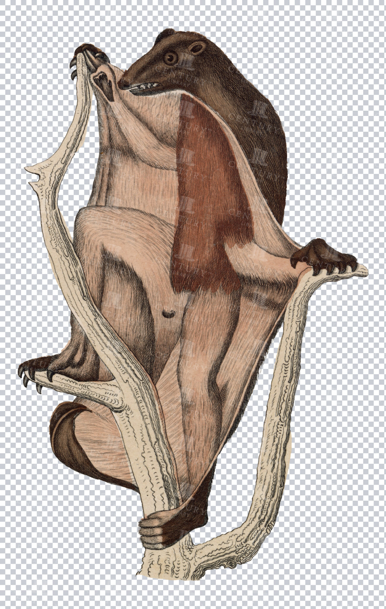
Vintage Engraving of Flying Lemur on Transparent Background
Detailed vintage illustration of a flying lemur, showing its gliding membrane on a transparent background. Ideal for educational resources, design projects, or zoological studies.
- Resolution: 2908 × 4578
- Image Type(s): PNG
- 19th-century
- Animal
- Antique
- Art
- artistic
- Background
- biology
- Black and white
- collectible
- Design
- detailed
- Drawing
- education
- Engraving
- Etching
- exotic
- fauna
- Flying
- gliding
- Harp
- historical
- History
- illustration
- isolated
- Lemur
- Mammal
- membrane
- monochrome
- natural
- Nature
- old-fashioned
- retro
- scientific
- Texture
- traditional
- transparent
- unique
- vintage
- Wildlife
- Zoology
From this collection

Antique Map of Eastern India, Burma, Siam, and French Indo-China
This antique map showcases Eastern India, Burma (now Myanmar), Siam (now Thailand), and French Indo-China (Vietnam, Laos, Cambodia), with a focus on the geopolitical boundaries and major cities of the early 20th century. The map provides a detailed view of the region's topographical features, including rivers, mountain ranges, and coastlines, reflecting the historical context of Southeast Asia during this period.
- Resolution: 7143 x 5100
- Image Type(s): JPG
- Antique
- antique map
- Asia
- Atlas
- Burma
- cartography
- cities
- coastlines
- colonial
- country
- cultural heritage
- early 20th century
- Eastern India
- exploration
- French Indo-China
- Geography
- geopolitical boundaries
- historical geography
- historical map
- History
- Landscape
- Map
- mountain ranges
- old map
- representation
- Rivers
- Siam
- Southeast Asia
- topography
- World
From this collection

Vintage Map of Southern England Including London, Brighton, and Major Coastal Cities
A vintage map of Southern England, highlighting major cities like London and Brighton, as well as coastal areas. The map provides detailed insights into the region's historical geography, transportation routes, and urban development.
- Resolution: 7129 x 5100
- Image Type(s): JPG
From this collection

Detailed Line Art Illustration of an Old Locomotive
A detailed vintage line art illustration of an old locomotive, showcasing the intricate design and mechanical components of historic trains.
- Image Type(s): PNG
Related Images

Antique Illustration of a Bee with Detailed Wing and Body Structure from the 1800s
This 1800s vintage illustration depicts a bee with highly detailed wings and body, exemplifying the insect's anatomy in historical natural history art.
- Resolution: 1079px x 1251px
- Image Type(s): PNG
Related Images

Antique Map of West Virginia
Detailed antique map of West Virginia, showing counties, towns, railroads, and geographical features. Historical 19th century cartography with insets of surrounding areas. An educational and collectible piece.
- Resolution: 7280 x 5100
- Image Type(s): JPG
- nostalgic
- cartographer
- state boundaries
- historical regions
- west virginia map
- west virginia counties
- surrounding areas
- heritage map
- vintage west virginia
- state map
- reference
- archival
- geographical features
- USA
- railroads
- detailed map
- topography
- historical map
- exploration
- old map
- cartography
- American history
- transportation
- counties
- towns
- education
- 19th-century
- collectible
- historical
- heritage
- classic
- vintage
- old
- representation
- Antique
- History
- West Virginia
- Geography
- Atlas
- World
- Globe
- Map
From this collection

Antique Map of Mexico Showing Topography and Major Cities
An antique map of Mexico displaying the topography, major cities, and transportation routes, with a focus on the geographical diversity and historical boundaries from the early 20th century.
- Resolution: 7163 x 5100
- Image Type(s): JPG
From this collection

Antique Map of Western England and Wales Including Detailed Regional Boundaries
An antique map of Western England and Wales, showcasing detailed regional boundaries and cities like Liverpool and Manchester. The map highlights important geographical features, transportation routes, and historical landmarks in the area.
- Resolution: 7126 x 5100
- Image Type(s): JPG
From this collection

Detailed Vintage Map of Central America Including Guatemala and Nicaragua
A detailed vintage map of Central America, featuring countries like Guatemala and Nicaragua. The map highlights important geographical features, cities, and transportation routes, providing a historical perspective on the region.
- Resolution: 7116 x 5100
- Image Type(s): JPG
From this collection

Antique 1800s Illustration of a Bat in Flight with Detailed Wing Structure
This vintage illustration from the 1800s showcases a bat in mid-flight, highlighting its detailed wing structure and nocturnal features, typical of historical art.
- Resolution: 4609px x 2799px
- Image Type(s): PNG
Related Images

Antique Map of Turkey in Asia with Russian Trans-Caucasia
A richly detailed antique map from the 19th century depicting Turkey in Asia, including regions like Anatolia, Armenia, Kurdistan, Mesopotamia, and Syria, along with parts of Russian Trans-Caucasia. The map highlights historical borders and settlements.
- Resolution: 7273 x 5100
- Image Type(s): JPG
From this collection
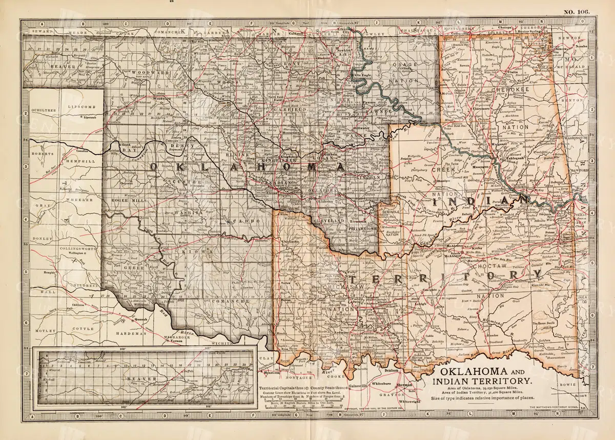
Antique Map of Oklahoma and Indian Territory from the 19th Century
This antique map from the 19th century illustrates Oklahoma and Indian Territory, showcasing the regions before statehood. It details the counties, settlements, and major transportation routes of the time.
- Resolution: 7249 x 5100
- Image Type(s): JPG
From this collection

Vintage Map of Minnesota Featuring Lakes and Urban Areas
A vintage map of Minnesota highlighting its numerous lakes, urban areas, and transportation routes, showcasing the state's geographical diversity from the early 20th century.
- Resolution: 7166 x 5100
- Image Type(s): JPG
From this collection

1897 Map of Italy: Central and Southern Regions
A detailed 1897 map highlighting the central and southern regions of Italy, including Sicily. The map showcases the topography, cities, and transportation routes of the time, providing a rich historical context of Italy during the late 19th century. The map includes notable cities such as Naples, Rome, and Palermo, along with detailed depictions of the surrounding areas.
- Resolution: 7151 x 5100
- Image Type(s): JPG
From this collection

Antique Map of Northern England Including Northumberland, Durham, and Isle of Man
An antique map of Northern England, showcasing regions like Northumberland and Durham, as well as the Isle of Man inset. The map provides detailed insights into the region's historical geography, including towns, transportation routes, and coastal features.
- Resolution: 7124 x 5100
- Image Type(s): JPG
From this collection

Vintage Eight-Pointed Heraldic Star Illustration
An isolated PNG image of a vintage eight-pointed star, often used in heraldic designs. The star is colored in alternating shades of gold and blue, symbolizing guidance, protection, and the heavens. This classic design element is ideal for use in projects that require historical or celestial themes.
- Resolution: 1255 x 1928
- Image Type(s): PNG
- Ancient
- Antique
- Art
- Artwork
- blue
- celestial
- classic
- coatofarms
- Compass
- Crest
- culture
- Decorative
- Design
- eightpointed
- Emblem
- five-spot
- Gold
- Graphic
- Heraldry
- historical
- History
- iconography
- identity
- illustration
- isolated
- legacy
- Machine
- mechanical device
- medieval
- Navigation
- nobility
- noble
- pinwheel
- PNG
- Royalty
- Shield
- Star
- style
- symbol
- tradition
- traditional
- vintage
- Wheel
Related Images
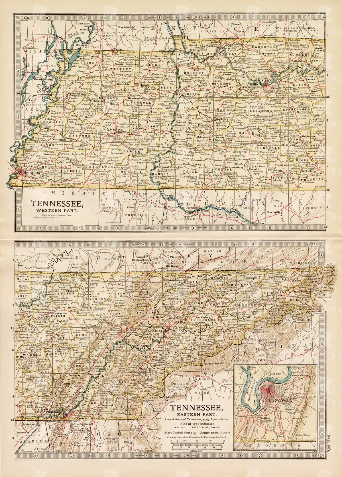
Antique Map of Tennessee, USA – Eastern and Western Parts
An antique map from the 19th century depicting both the eastern and western parts of Tennessee, USA. The map shows various towns, railways, and natural features, providing a comprehensive view of the state’s geography and development during the period.
- Resolution: 7268 x 5100
- Image Type(s): JPG
From this collection

Vintage Map of Nevada and Utah
An antique map detailing the states of Nevada and Utah, showcasing the topography, settlements, and infrastructure from the late 19th to early 20th century, with insets of major cities.
- Resolution: 7237 x 5100
- Image Type(s): JPG
From this collection

Vintage Map of Massachusetts and Surrounding Regions
A vintage map of Massachusetts showing detailed topography, cities, and transportation networks, including an inset of the Boston metropolitan area from the early 20th century.
- Resolution: 7162 x 5100
- Image Type(s): JPG
From this collection

1897 Map of Maine Highlighting Counties and Coastal Areas
This 1897 map of Maine provides a detailed view of the state's counties, towns, and coastal areas. The map illustrates the geographical features and administrative divisions of Maine during the late 19th century, offering a historical perspective on the region's development. Its vintage design makes it a significant resource for those interested in Maine's history.
- Resolution: 7159 x 5100
- Image Type(s): JPG
From this collection

1897 Map of Italy: Northern Regions
This 1897 map offers a comprehensive view of Northern Italy, detailing its cities, mountain ranges, and infrastructure. The map covers important regions such as Piedmont, Lombardy, and Veneto, highlighting the area's rich history and development during the 19th century. It serves as a valuable historical document for understanding Italy's northern landscape at the time.
- Resolution: 7152 x 5100
- Image Type(s): JPG
From this collection
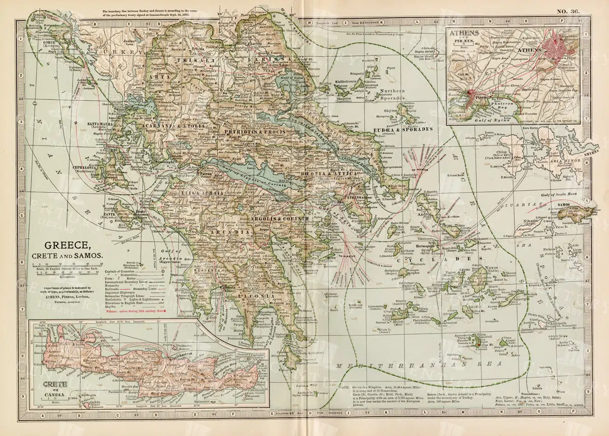
Antique Map of Greece Highlighting Crete and Samos with Detailed Topography
This antique map of Greece highlights the regions of Crete and Samos, showing detailed topographical features such as mountains, rivers, and coastlines. The map provides a historical overview of the geopolitical boundaries, major cities, and maritime routes in the Aegean Sea during the late 19th century. It offers a valuable perspective on the landscape and political divisions of Greece and its islands at the time.
- Resolution: 7140 x 5100
- Image Type(s): JPG
From this collection

Antique Map of New Brunswick, Nova Scotia, and Prince Edward Island
A historic map from the late 19th century illustrating the Canadian provinces of New Brunswick, Nova Scotia, and Prince Edward Island, featuring key cities, towns, and geographical landmarks.
- Resolution: 7238 x 5100
- Image Type(s): JPG
- 19th-century
- Antique
- Atlantic
- Atlas
- Borders
- Canada
- cartography
- cities
- classic
- coastline
- colonial
- country
- Geography
- Globe
- heritage
- History
- illustration
- Landscape
- Map
- maritime
- new brunswick
- novascotia
- Ocean
- princeed ward island
- provinces
- regions
- representation
- Rivers
- Road
- settlements
- territory
- topography
- tourism
- towns
- Travel
- vintage
- World
From this collection

Historical Map of Manitoba, British Columbia, and the Northwest Territories
A detailed historical map depicting the regions of Manitoba, British Columbia, and the Northwest Territories, showcasing topographical features, settlements, and boundaries in the early 20th century.
- Resolution: 7160 x 5100
- Image Type(s): JPG
- topographical
- northwest
- columbia
- manitoba
- settlements
- early
- 20th
- demographics
- century
- provincial
- division
- resources
- settlement
- climate
- infrastructure
- regions
- boundaries
- colonial
- territories
- exploration
- cartography
- transportation
- coastline
- historical
- natural
- vintage
- representation
- Antique
- History
- River
- Geography
- Atlas
- British
- World
- Landscape
- Canada
- Globe
- Map
- Travel
- Borders
From this collection

Vintage Map of Northern England and Wales Highlighting Major Cities and Geographic Features
A vintage map of Northern England and Wales, detailing major cities, towns, and geographical features. The map includes important transportation routes and provides a historical overview of the region during the period.
- Resolution: 7125 x 5100
- Image Type(s): JPG
From this collection

Red Heraldic Lion in Vintage Style Illustration
A striking isolated PNG image of a red lion, rendered in a vintage heraldic style. The lion is depicted in a rearing posture, symbolizing strength, courage, and nobility. This traditional design element is ideal for use in projects that require a bold and historic emblem.
- Resolution: 967 x 1899
- Image Type(s): PNG
Related Images

Antique Map of Wisconsin
Historical antique map of Wisconsin, showing counties, towns, railroads, rivers, and other geographical features. A 19th century map that illustrates the development and infrastructure of the state.
- Resolution: 7281 x 5100
- Image Type(s): JPG
- nostalgic
- cartographer
- state boundaries
- historical regions
- heritage map
- wisconsin map
- wisconsin counties
- vintage wisconsin
- historical development
- state map
- reference
- geographical features
- USA
- infrastructure
- railroads
- detailed map
- topography
- historical map
- exploration
- old map
- cartography
- American history
- transportation
- counties
- towns
- education
- 19th-century
- collectible
- historical
- heritage
- classic
- vintage
- representation
- Antique
- History
- Wisconsin
- Geography
- Atlas
- World
- Rivers
- Map
From this collection

Historic Map of North Carolina
A detailed antique map of North Carolina, highlighting its counties, cities, and key geographical features, showcasing the state's landscape during the late 19th century.
- Resolution: 7243 x 5100
- Image Type(s): JPG
From this collection

Antique Map of Southern Michigan and Urban Development
An antique map of Southern Michigan detailing urban development, major cities, and transportation networks, including Detroit, from the early 20th century.
- Resolution: 7165 x 5100
- Image Type(s): JPG
From this collection
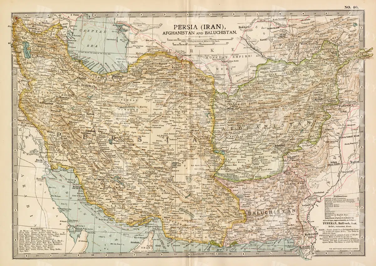
Antique Map of Persia, Afghanistan, and Baluchistan with Geopolitical Borders
This antique map of Persia (modern-day Iran), Afghanistan, and Baluchistan highlights the geopolitical borders and key cities of the early 20th century. The map details the region's topographical features, including mountain ranges, rivers, and deserts, offering a comprehensive view of the landscape. It provides a historical perspective on the political and geographical divisions in this part of the Middle East and South Asia during the period.
- Resolution: 7148 x 5100
- Image Type(s): JPG
- Afghanistan
- Afghanistan history
- Antique
- antique map
- Atlas
- Baluchistan
- cartography
- cities
- colonial
- country
- deserts
- early 20th century
- exploration
- Geography
- geopolitical borders
- historical geography
- historical map
- History
- Iran
- Landscape
- Map
- Middle East
- mountain ranges
- old map
- Persia
- Persia history
- representation
- Rivers
- South Asia
- topography
- World
From this collection

Antique Map of Central and Eastern England Including Nottingham and Cambridge
An antique map of Central and Eastern England, featuring detailed views of cities like Nottingham and Cambridge. The map highlights important transportation networks, geographical features, and regional boundaries, offering historical context for the area.
- Resolution: 7128 x 5100
- Image Type(s): JPG
From this collection

Vintage Map of Eastern China with Detailed Regions and Cities like Beijing and Shanghai
A vintage map of Eastern China, detailing major cities such as Beijing and Shanghai. The map provides insights into the region's geography, transportation networks, and historical context, offering a comprehensive view of Eastern China's layout.
- Resolution: 7118 x 5100
- Image Type(s): JPG
From this collection

Detailed Vintage Map of Southeast Australia Including Victoria, New South Wales, and South Australia
A detailed vintage map showing the southeast part of Australia, including Victoria, New South Wales, and parts of South Australia and Queensland. The map highlights major cities, railways, and geographical features, offering a historical perspective on the region's layout during the period.
- Resolution: 7110 x 5100
- Image Type(s): JPG
From this collection

Vintage Illustration of Bats Flying in the Night Sky from the 1800s
An antique illustration depicting bats flying against a night sky, highlighting their silhouettes and nocturnal behavior, common in 1800s natural history art.
- Resolution: 3143px x 3645px
- Image Type(s): PNG
Related Images

Antique Map of Western New York
A detailed historic map showcasing the western part of New York, highlighting counties, cities, and geographical features, including insets of major urban areas like Buffalo and Rochester.
- Resolution: 7241 x 5100
- Image Type(s): JPG
From this collection

Vintage Map of Northern New York
An antique map focusing on the northern and eastern parts of New York, showing the state's counties, cities, and significant natural features, typical of late 19th-century cartography.
- Resolution: 7240 x 5100
- Image Type(s): JPG
From this collection

1897 Map of Kansas with Detailed County Lines and Railroads
A historical map from 1897 showing Kansas with a focus on county lines, railroads, and major cities. The map provides a detailed representation of the state's infrastructure and development during the late 19th century, offering valuable insights into the region's history and growth. The vintage design adds to its appeal as a historical artifact.
- Resolution: 7156 x 5100
- Image Type(s): JPG
From this collection

Vintage Map of Northern California Including San Francisco and Yosemite Valley
A vintage map depicting the northern part of California, highlighting major cities like San Francisco and natural landmarks such as Yosemite Valley. The map provides detailed insights into the region's geographical features, transportation routes, and historical importance.
- Resolution: 7113 x 5100
- Image Type(s): JPG
From this collection

Empire of Austria-Hungary Historical Map with Detailed Regional Boundaries and Railways
This historical map of the Austria-Hungary Empire showcases detailed regional boundaries, cities, and extensive railway networks. The map includes significant areas like Budapest and Vienna, providing a comprehensive view of the empire's geographical and political landscape during the period.
- Resolution: 7112 x 5100
- Image Type(s): JPG
From this collection

Antique Historical Map of Western Austria-Hungary Featuring Vienna and Prague
An antique map of the western part of Austria-Hungary, highlighting major cities like Vienna and Prague. The map provides intricate details of regional boundaries, railway networks, and topographical features, reflecting the historical political landscape of the region.
- Resolution: 7111 x 5100
- Image Type(s): JPG
From this collection

Heraldic Swan in Vintage Medieval Style
An isolated PNG image of a swan, rendered in a vintage medieval style. The swan is detailed with elegant plumage and a regal posture, often representing purity, grace, and nobility in heraldic traditions. This illustration is perfect for adding a touch of classic elegance to any design project.
- Resolution: 1428 x 1799
- Image Type(s): PNG
Related Images

Support the Library
Our supporters and members help us continue collecting and restoring these wonderful pieces of art for the modern creator
Unlock Everything and Become a Member!
While a lot of the library is available for free, some is kept behind closed dusty doors only to be accessed by our lovely members.