

Detailed Vintage Map of Central America Including Guatemala and Nicaragua
A detailed vintage map of Central America, featuring countries like Guatemala and Nicaragua. The map highlights important geographical features, cities, and transportation routes, providing a historical perspective on the region.
- Resolution: 7116 x 5100
- Image Type(s): JPG
From this collection

Greek Muse Erato Holding a Lyre with Flowing Robes and Laurel Wreath
This image is part of our Extensive Collection of 135 Greek, Roman, and Mythology Vintage Line Art Illustrations. Each piece hand-selected from a variety of 19th-century books and ephemera found within our private library.
- Image Type(s): PNG
From this collection

Virginian Uhu Perched on Branch Line Art Illustration
Illustration of a Virginian Uhu perched on a branch in line art, showcasing its distinctive ear tufts and powerful build in a natural setting
- Resolution: 3668px x 4553px
- Image Type(s): PNG
Related Images

Antique Map of Turkey in Asia with Russian Trans-Caucasia
A richly detailed antique map from the 19th century depicting Turkey in Asia, including regions like Anatolia, Armenia, Kurdistan, Mesopotamia, and Syria, along with parts of Russian Trans-Caucasia. The map highlights historical borders and settlements.
- Resolution: 7273 x 5100
- Image Type(s): JPG
From this collection
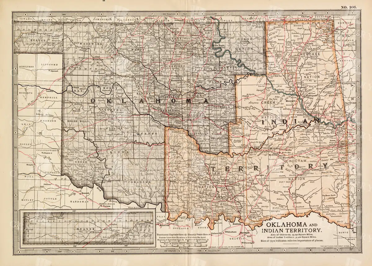
Antique Map of Oklahoma and Indian Territory from the 19th Century
This antique map from the 19th century illustrates Oklahoma and Indian Territory, showcasing the regions before statehood. It details the counties, settlements, and major transportation routes of the time.
- Resolution: 7249 x 5100
- Image Type(s): JPG
From this collection

Historic Map of New Jersey
A detailed antique map of New Jersey, highlighting its counties, cities, and significant landmarks, reflecting the state's geography and development during the late 19th century.
- Resolution: 7239 x 5100
- Image Type(s): JPG
From this collection

Vintage Map of Minnesota Featuring Lakes and Urban Areas
A vintage map of Minnesota highlighting its numerous lakes, urban areas, and transportation routes, showcasing the state's geographical diversity from the early 20th century.
- Resolution: 7166 x 5100
- Image Type(s): JPG
From this collection

1897 Map of Italy: Central and Southern Regions
A detailed 1897 map highlighting the central and southern regions of Italy, including Sicily. The map showcases the topography, cities, and transportation routes of the time, providing a rich historical context of Italy during the late 19th century. The map includes notable cities such as Naples, Rome, and Palermo, along with detailed depictions of the surrounding areas.
- Resolution: 7151 x 5100
- Image Type(s): JPG
From this collection

Antique Map of Northern England Including Northumberland, Durham, and Isle of Man
An antique map of Northern England, showcasing regions like Northumberland and Durham, as well as the Isle of Man inset. The map provides detailed insights into the region's historical geography, including towns, transportation routes, and coastal features.
- Resolution: 7124 x 5100
- Image Type(s): JPG
From this collection

Vintage 1800s Map of Southern Africa Including South Africa, Namibia, and Surrounding Territories – Antique Map
A vintage map from the 1800s depicting Southern Africa, including South Africa, Namibia, and surrounding territories. This antique map highlights the region’s colonial borders, cities, and natural features, offering a detailed view of the area during the colonial period. Perfect for history and cartography enthusiasts.
- Resolution: 7103 x 5100
- Image Type(s): JPG
From this collection

Vintage Palm Reading Illustration – Palm of Hand No.5
- License Info
- Resolution: 1944px x 3086px
From this collection

ART NOUVEAU Shields and Banners for Type and Logos – Vintage Stock Illustrations
The type foundry and print shop of old would create books, like the one this image was discovered within, to help customers and clients with their design choices. Naturally, these books were jam packed with useful illustrative elements that could be combined to create a final piece. Today, these books are extremely difficult to get a hold of. Especially those that were published in the late 1800s. They were not mainstream publications, they simply served as 'catalogs' and thus were only produced in small numbers. Fortunately, we were introduced to a collector who had precisely what we had been searching for for so long. After some costly negotiations, we're very excited to be able to share the wonderful gems within.
- License Info
- Resolution: 9098 x 12652
- Year of Print: Late 1800s
- Artist: A Bertrand
Related Images
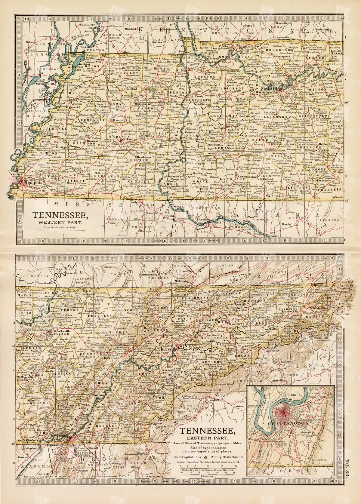
Antique Map of Tennessee, USA – Eastern and Western Parts
An antique map from the 19th century depicting both the eastern and western parts of Tennessee, USA. The map shows various towns, railways, and natural features, providing a comprehensive view of the state’s geography and development during the period.
- Resolution: 7268 x 5100
- Image Type(s): JPG
From this collection
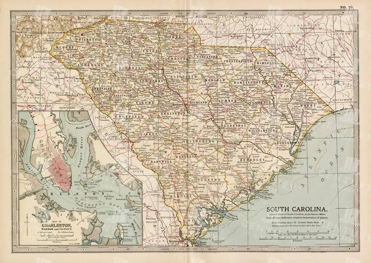
19th Century South Carolina Map with Charleston Harbor Inset
A detailed 19th century map of South Carolina, featuring an inset of Charleston Harbor. This vintage map provides a glimpse into the state's political and geographical landscape during the era, highlighting cities, transportation routes, and natural features.
- Resolution: 7263 x 5100
- Image Type(s): JPG
- 1800s
- 19th-century
- American history
- antique cartography
- antique map
- antique paper
- archival
- Atlas
- cartographic history
- cartography
- Charleston Harbor
- Charleston history
- cities
- country
- geographical features
- Geography
- heritage
- historical artifact
- historical document
- historical geography
- historical information
- historical map
- historical records
- history lovers
- Map
- map of South Carolina
- old map
- old South Carolina
- political divisions
- representation
- South Carolina
- topography
- United States
- vintage
- vintage map
- World
From this collection
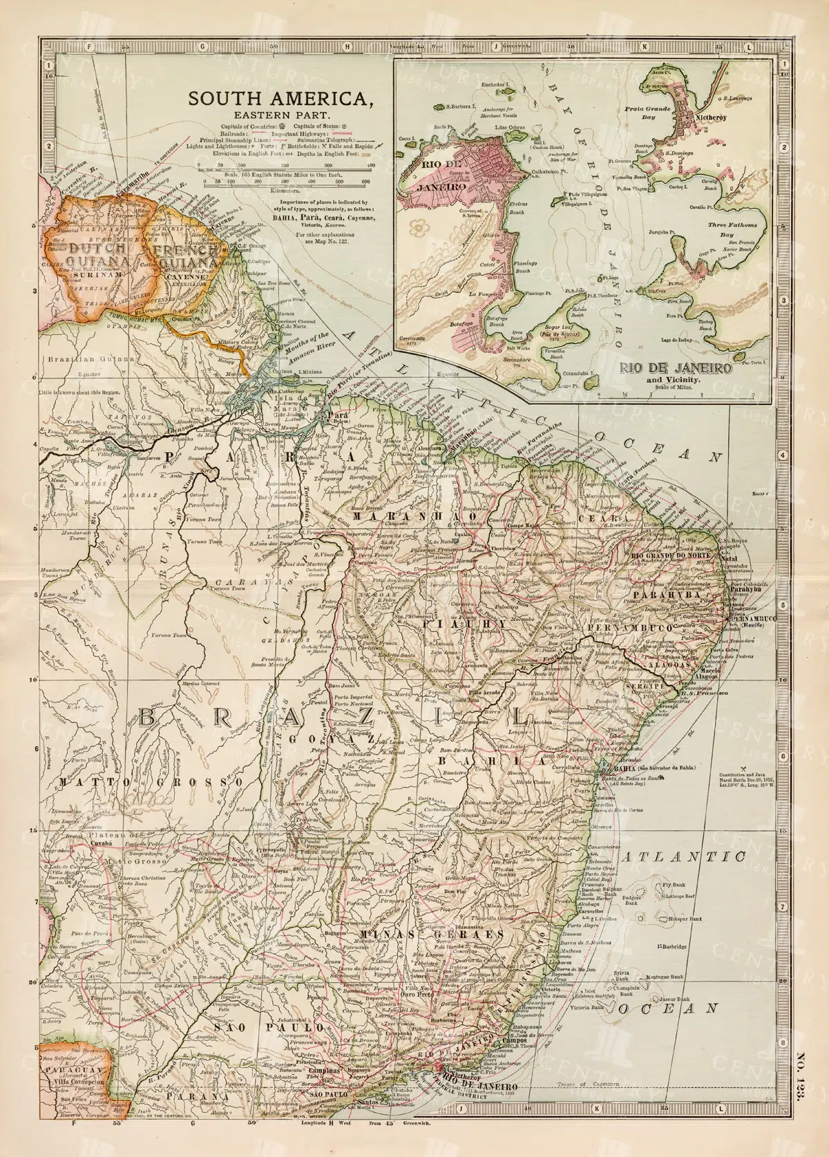
19th Century Map of Eastern South America Including Rio de Janeiro
A detailed 19th century map of Eastern South America, focusing on countries like Brazil, French Guiana, and others, with a special inset of Rio de Janeiro. This vintage map illustrates the political and geographical landscape of the time, with precise details of cities and natural features.
- Resolution: 7259 x 5100
- Image Type(s): JPG
- 1800s
- 19th-century
- antique cartography
- antique map
- antique paper
- archival
- Atlas
- Brazil
- cartographic history
- cartography
- cities
- Eastern South America
- French Guiana
- geographical features
- Geography
- heritage
- historical artifact
- historical document
- historical geography
- historical information
- historical map
- historical records
- history lovers
- Latin America
- Map
- map of Brazil
- old map
- old South America
- political divisions
- representation
- Rio de Janeiro
- South America
- South American history
- topography
- vintage
- vintage map
- World
From this collection
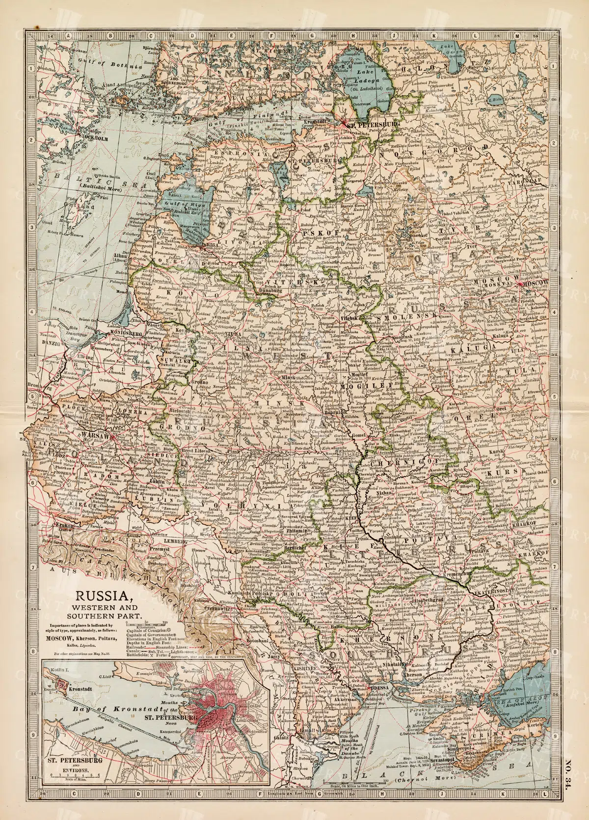
19th Century Map of Russia’s Western and Southern Parts with St. Petersburg
A detailed 19th century map highlighting the western and southern parts of Russia, including the prominent city of St. Petersburg. This vintage map showcases the political and geographical landscape of the era, featuring intricate details of cities, rivers, and borders.
- Resolution: 7257 x 5100
- Image Type(s): JPG
- 1800s
- 19th-century
- Antique
- antique cartography
- antique map
- antique paper
- archival
- Atlas
- Baltic Sea
- cartographic history
- cartography
- cities
- Eastern Europe
- european history
- geographical features
- Geography
- heritage
- historical artifact
- historical document
- historical geography
- historical information
- historical map
- historical records
- history lovers
- Map
- map of Russia
- old
- old Europe
- old map
- political divisions
- representation
- Rivers
- Russia
- Russian Empire
- southern Russia
- St. Petersburg
- St. Petersburg history
- topography
- vintage
- vintage map
- western Russia
From this collection

Vintage Map of Nevada and Utah
An antique map detailing the states of Nevada and Utah, showcasing the topography, settlements, and infrastructure from the late 19th to early 20th century, with insets of major cities.
- Resolution: 7237 x 5100
- Image Type(s): JPG
From this collection

Vintage Map of Massachusetts and Surrounding Regions
A vintage map of Massachusetts showing detailed topography, cities, and transportation networks, including an inset of the Boston metropolitan area from the early 20th century.
- Resolution: 7162 x 5100
- Image Type(s): JPG
From this collection

1897 Map of Maine Highlighting Counties and Coastal Areas
This 1897 map of Maine provides a detailed view of the state's counties, towns, and coastal areas. The map illustrates the geographical features and administrative divisions of Maine during the late 19th century, offering a historical perspective on the region's development. Its vintage design makes it a significant resource for those interested in Maine's history.
- Resolution: 7159 x 5100
- Image Type(s): JPG
From this collection

1897 Map of Italy: Northern Regions
This 1897 map offers a comprehensive view of Northern Italy, detailing its cities, mountain ranges, and infrastructure. The map covers important regions such as Piedmont, Lombardy, and Veneto, highlighting the area's rich history and development during the 19th century. It serves as a valuable historical document for understanding Italy's northern landscape at the time.
- Resolution: 7152 x 5100
- Image Type(s): JPG
From this collection
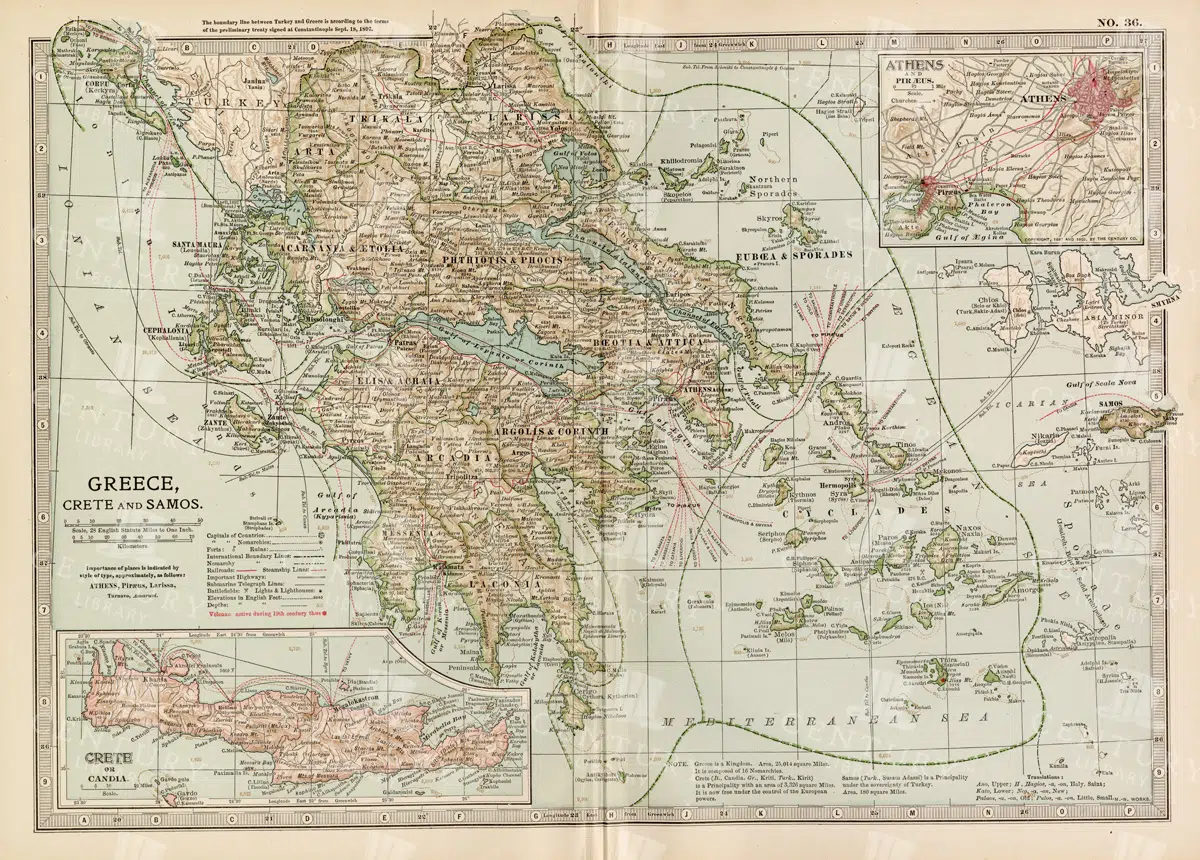
Antique Map of Greece Highlighting Crete and Samos with Detailed Topography
This antique map of Greece highlights the regions of Crete and Samos, showing detailed topographical features such as mountains, rivers, and coastlines. The map provides a historical overview of the geopolitical boundaries, major cities, and maritime routes in the Aegean Sea during the late 19th century. It offers a valuable perspective on the landscape and political divisions of Greece and its islands at the time.
- Resolution: 7140 x 5100
- Image Type(s): JPG
From this collection

Vintage Engineering Illustration of a Hand Powered Drill Press
- License Info
- Resolution: 2849px x 4472px
Related Images

HUMAN Blood Vessels – Vintage 1882 Encyclopedia Print
- License Info
- Resolution: 8650px x 10605px
- Year of Print: 1882
Related Images

CANAL – Antique Steel Engraving of ‘Der Distellochdamm’ Marx, Alexander
- License Info
- Resolution: 10400 x 7200 300dpi
- Year of Print: 1847
Related Images

Mythological Embrace of Zephyrus and Chloris Amidst Flowing Clouds in Greek Art
This image is part of our Extensive Collection of 135 Greek, Roman, and Mythology Vintage Line Art Illustrations. Each piece hand-selected from a variety of 19th-century books and ephemera found within our private library.
- Image Type(s): PNG
From this collection

Vintage Illustration of Otter Skeleton in a Walking Pose as Transparent PNG
A vintage illustration of an otter skeleton in a walking pose, showing its elongated body and detailed bone structure. This transparent PNG is perfect for scientific and wildlife studies.
- Resolution: 3328px x 1294px
- Image Type(s): PNG
From this collection

Vintage Illustration of Paddle-Tailed Pterosaur with Extended Wings as Transparent PNG
A detailed vintage illustration of a paddle-tailed pterosaur with extended wings, showcasing its unique features. This transparent PNG is perfect for prehistoric and educational projects, highlighting the pterosaur's distinct anatomy.
- Resolution: 3037px x 2175px
- Image Type(s): PNG
Related Images

Detailed 19th Century Map of Ontario with Inset of Toronto and Vicinity
A richly detailed map of Ontario from the late 19th century, featuring county divisions, cities, and a prominent inset of Toronto and its surrounding areas, highlighting important transportation routes.
- Resolution: 7250 x 5100
- Image Type(s): JPG
From this collection

Antique Map of New Brunswick, Nova Scotia, and Prince Edward Island
A historic map from the late 19th century illustrating the Canadian provinces of New Brunswick, Nova Scotia, and Prince Edward Island, featuring key cities, towns, and geographical landmarks.
- Resolution: 7238 x 5100
- Image Type(s): JPG
- 19th-century
- Antique
- Atlantic
- Atlas
- Borders
- Canada
- cartography
- cities
- classic
- coastline
- colonial
- country
- Geography
- Globe
- heritage
- History
- illustration
- Landscape
- Map
- maritime
- new brunswick
- novascotia
- Ocean
- princeed ward island
- provinces
- regions
- representation
- Rivers
- Road
- settlements
- territory
- topography
- tourism
- towns
- Travel
- vintage
- World
From this collection

Historical Map of Manitoba, British Columbia, and the Northwest Territories
A detailed historical map depicting the regions of Manitoba, British Columbia, and the Northwest Territories, showcasing topographical features, settlements, and boundaries in the early 20th century.
- Resolution: 7160 x 5100
- Image Type(s): JPG
- 20th
- Antique
- Atlas
- Borders
- boundaries
- British
- Canada
- cartography
- century
- climate
- coastline
- colonial
- columbia
- demographics
- division
- early
- exploration
- Geography
- Globe
- historical
- History
- infrastructure
- Landscape
- manitoba
- Map
- natural
- northwest
- provincial
- regions
- representation
- resources
- River
- settlement
- settlements
- territories
- topographical
- transportation
- Travel
- vintage
- World
From this collection

Historical Map of the Eastern Part of the German Empire
This historical map of the eastern part of the German Empire showcases its towns, roads, and geographical features in great detail. The map offers a glimpse into the region’s past, highlighting key cities like Berlin and Hamburg. Insets provide additional details about these major cities, making the map an essential resource for historians and collectors interested in German history and cartography.
- Resolution: 7137 x 5100
- Image Type(s): JPG
- Antique
- antique geography
- antique map
- Atlas
- Berlin
- berlin map
- detailed german map
- detailed map
- Eastern
- eastern german map
- eastern germany
- Geography
- german cartography
- german cities
- german empire
- german empire map
- german geography
- german history
- german regions
- german towns
- german vintage
- hamburg
- hamburg map
- historical
- historical geography
- historical german map
- historical germany map
- historical map
- Map
- old germany map
- old map
- representation
- Roads
- towns
- vintage
- vintage cartography
- vintage germany
- World
From this collection

Vintage Map of Northern England and Wales Highlighting Major Cities and Geographic Features
A vintage map of Northern England and Wales, detailing major cities, towns, and geographical features. The map includes important transportation routes and provides a historical overview of the region during the period.
- Resolution: 7125 x 5100
- Image Type(s): JPG
From this collection
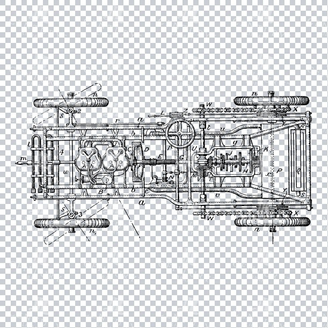
Vintage Line Art Mechanical Blueprint of a Car Illustration No.1
- License Info
- Resolution: 4216px x 2285px
Related Images


Greek Goddess Hera in Flowing Draped Robes with Ornamental Headpiece Holding Sphere
This image is part of our Extensive Collection of 135 Greek, Roman, and Mythology Vintage Line Art Illustrations. Each piece hand-selected from a variety of 19th-century books and ephemera found within our private library.
- Image Type(s): PNG
From this collection

Prometheus Carrying Fire and Offering Sacrificial Fruits in Classical Greek Mythology Lineart
This image is part of our Extensive Collection of 135 Greek, Roman, and Mythology Vintage Line Art Illustrations. Each piece hand-selected from a variety of 19th-century books and ephemera found within our private library.
- Image Type(s): PNG
From this collection

Antique Map of Wisconsin
Historical antique map of Wisconsin, showing counties, towns, railroads, rivers, and other geographical features. A 19th century map that illustrates the development and infrastructure of the state.
- Resolution: 7281 x 5100
- Image Type(s): JPG
- nostalgic
- cartographer
- state boundaries
- historical regions
- heritage map
- wisconsin map
- wisconsin counties
- vintage wisconsin
- historical development
- state map
- reference
- geographical features
- USA
- infrastructure
- railroads
- detailed map
- topography
- historical map
- exploration
- old map
- cartography
- American history
- transportation
- counties
- towns
- education
- 19th-century
- collectible
- historical
- heritage
- classic
- vintage
- representation
- Antique
- History
- Wisconsin
- Geography
- Atlas
- World
- Rivers
- Map
From this collection

19th Century Russia in Europe with Poland and Finland Vintage Map
A detailed 19th century map depicting Russia in Europe, including Poland and Finland. This historical artifact provides insight into the territorial boundaries and political divisions of the time, with intricate detailing of cities, rivers, and topographical features.
- Resolution: 7256 x 5100
- Image Type(s): JPG
- 1800s
- 19th-century
- Antique
- antique cartography
- antique map
- antique paper
- archival
- Atlas
- Baltic Sea
- Black Sea
- cartographic history
- cartography
- cities
- Eastern Europe
- european history
- Finland
- Finland history
- Geography
- heritage
- historical artifact
- historical document
- historical geography
- historical information
- historical map
- historical records
- history lovers
- Map
- map of Russia
- old Europe
- old map
- Poland
- Poland history
- political divisions
- representation
- Rivers
- Russia in Europe
- Russian Empire
- territorial boundaries
- topography
- vintage
- vintage map
- World
From this collection

Antique Map of Western Pennsylvania from the 19th Century with Pittsburgh Inset
This antique map highlights Western Pennsylvania from the 19th century, featuring cities, counties, and transportation routes. Includes an inset of Pittsburgh and its vicinity, showcasing urban growth.
- Resolution: 7252 x 5100
- Image Type(s): JPG
From this collection

Historic Map of North Carolina
A detailed antique map of North Carolina, highlighting its counties, cities, and key geographical features, showcasing the state's landscape during the late 19th century.
- Resolution: 7243 x 5100
- Image Type(s): JPG
From this collection

Antique Map of Southern Michigan and Urban Development
An antique map of Southern Michigan detailing urban development, major cities, and transportation networks, including Detroit, from the early 20th century.
- Resolution: 7165 x 5100
- Image Type(s): JPG
From this collection
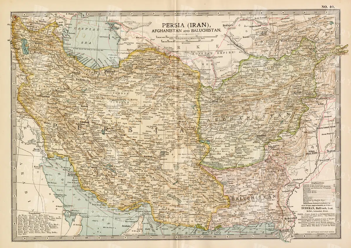
Antique Map of Persia, Afghanistan, and Baluchistan with Geopolitical Borders
This antique map of Persia (modern-day Iran), Afghanistan, and Baluchistan highlights the geopolitical borders and key cities of the early 20th century. The map details the region's topographical features, including mountain ranges, rivers, and deserts, offering a comprehensive view of the landscape. It provides a historical perspective on the political and geographical divisions in this part of the Middle East and South Asia during the period.
- Resolution: 7148 x 5100
- Image Type(s): JPG
- Afghanistan
- Afghanistan history
- Antique
- antique map
- Atlas
- Baluchistan
- cartography
- cities
- colonial
- country
- deserts
- early 20th century
- exploration
- Geography
- geopolitical borders
- historical geography
- historical map
- History
- Iran
- Landscape
- Map
- Middle East
- mountain ranges
- old map
- Persia
- Persia history
- representation
- Rivers
- South Asia
- topography
- World
From this collection

Vintage Map of the Southwestern Part of the German Empire with Regional Details
This vintage map of the southwestern part of the German Empire details the region’s cities, roads, and geographical features. The map provides a historical overview of the area, including key locations like Munich and Stuttgart. The vintage style and precise detailing make it an essential resource for those interested in the history and geography of this region. The map also includes insets of specific cities, offering additional insight into the urban development of the time.
- Resolution: 7139 x 5100
- Image Type(s): JPG
- historical german map
- detailed german map
- old germany map
- german vintage
- german towns
- german regions
- historical germany map
- german cities
- vintage germany
- german geography
- southwestern
- munich
- southwestern german map
- southwestern germany
- stuttgart map
- munich map
- stuttgart
- german empire map
- german cartography
- german history
- german empire
- detailed map
- vintage cartography
- antique geography
- historical geography
- antique map
- historical map
- old map
- towns
- historical
- Roads
- vintage
- old
- representation
- Antique
- Geography
- Atlas
- World
- Map
From this collection

Detailed Map of the Northern Part of the German Empire with Key Cities
This detailed map of the northern part of the German Empire highlights key cities such as Hamburg and Berlin, along with roads and geographical features. The map offers a historical perspective on the region's landscape and its urban development during the time period. Its vintage style and detailed cartography make it an invaluable resource for collectors and history enthusiasts. The map’s detailed depiction of the area’s geography is a window into the past.
- Resolution: 7138 x 5100
- Image Type(s): JPG
- Antique
- antique geography
- antique map
- Atlas
- Berlin
- berlin map
- detailed german map
- detailed map
- Geography
- german cartography
- german cities
- german empire
- german empire map
- german geography
- german history
- german regions
- german towns
- german vintage
- hamburg
- hamburg map
- historical
- historical geography
- historical german map
- historical germany map
- historical map
- Map
- northern
- northern german map
- northern germany
- old germany map
- old map
- representation
- Roads
- towns
- vintage
- vintage cartography
- vintage germany
- World
From this collection

Antique Map of Central and Eastern England Including Nottingham and Cambridge
An antique map of Central and Eastern England, featuring detailed views of cities like Nottingham and Cambridge. The map highlights important transportation networks, geographical features, and regional boundaries, offering historical context for the area.
- Resolution: 7128 x 5100
- Image Type(s): JPG
From this collection

Vintage Map of Eastern China with Detailed Regions and Cities like Beijing and Shanghai
A vintage map of Eastern China, detailing major cities such as Beijing and Shanghai. The map provides insights into the region's geography, transportation networks, and historical context, offering a comprehensive view of Eastern China's layout.
- Resolution: 7118 x 5100
- Image Type(s): JPG
From this collection

Detailed Vintage Map of Southeast Australia Including Victoria, New South Wales, and South Australia
A detailed vintage map showing the southeast part of Australia, including Victoria, New South Wales, and parts of South Australia and Queensland. The map highlights major cities, railways, and geographical features, offering a historical perspective on the region's layout during the period.
- Resolution: 7110 x 5100
- Image Type(s): JPG
From this collection
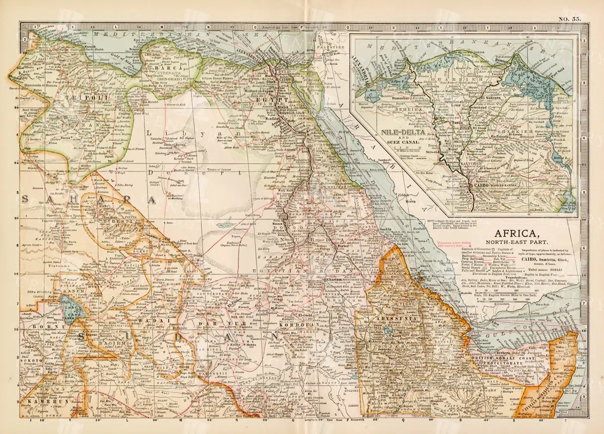
Vintage 1800s Map of North-East Africa Including Egypt, Sudan, and the Nile Delta – Antique Historical Map
This vintage map from the 1800s illustrates North-East Africa, including Egypt, Sudan, and the Nile Delta. The map is a beautiful representation of the region's historical geography, showing important cities, boundaries, and geographical features from the colonial era. A valuable piece for those interested in African history and cartography.
- Resolution: 7101 x 5100
- Image Type(s): JPG
- 1800s
- Africa
- Africa colonial
- Africa map
- Antique
- antique map
- Atlas
- boundaries
- cartography
- cities
- colonial era
- detailed
- Egypt
- exploration
- Geography
- historical
- historical geography
- historical map
- illustration
- Map
- Nile Delta
- North-East Africa
- old map
- preserved
- representation
- retro
- Rivers
- Sudan
- topography
- Travel
- vintage
- vintage map
- World
From this collection
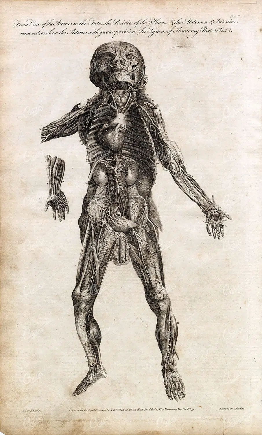
HUMAN ANATOMY – Front View of Arteries with Muscles Removed – Full Body
You're looking at a scarce, 229 year old, steel plate engraving from the original "The New Encyclopaedia Or Modern Universal Dictionary Of Arts And Sciences On A New And Improved Plan" by Hall, William Henry, Bedford Row, London, published by C Cooke, London.
- License Info
- Resolution: 8300 x 13800 300dpi
- Year of Print: 1791
- Artist: C. Cooke
Related Images
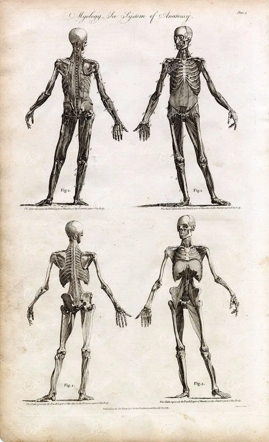
ANATOMY – Antique Human Myology Print – Rare Full Body Engraving
You're looking at a scarce, 229 year old, steel plate engraving from the original "The New Encyclopaedia Or Modern Universal Dictionary Of Arts And Sciences On A New And Improved Plan" by Hall, William Henry, Bedford Row, London, published by C Cooke, London.
- License Info
- Resolution: 8300 x 13800 300dpi
- Year of Print: 1791
- Artist: C. Cooke
Related Images

WESTERN Hemisphere Globe Map
- License Info
- Resolution: 10000 x 12600 300dpi
- Artist: New Ideal Atlas
Related Images

Support the Library
Our supporters and members help us continue collecting and restoring these wonderful pieces of art for the modern creator
Unlock Everything and Become a Member!
While a lot of the library is available for free, some is kept behind closed dusty doors only to be accessed by our lovely members.