
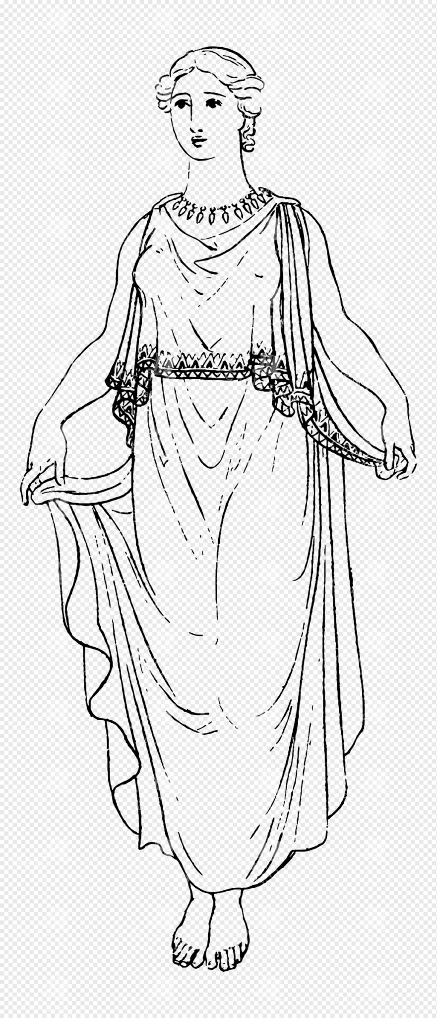
Greek Mythology Lineart Illustration of Hera Wearing Flowing Robes with Ornate Jewelry
This image is part of our Extensive Collection of 135 Greek, Roman, and Mythology Vintage Line Art Illustrations. Each piece hand-selected from a variety of 19th-century books and ephemera found within our private library.
- Image Type(s): PNG
From this collection

Antique Map of Western New York
A detailed historic map showcasing the western part of New York, highlighting counties, cities, and geographical features, including insets of major urban areas like Buffalo and Rochester.
- Resolution: 7241 x 5100
- Image Type(s): JPG
From this collection

Vintage Map of Northern New York
An antique map focusing on the northern and eastern parts of New York, showing the state's counties, cities, and significant natural features, typical of late 19th-century cartography.
- Resolution: 7240 x 5100
- Image Type(s): JPG
From this collection

Historical Map of Northern Michigan and Surrounding Great Lakes
A historical map of Northern Michigan, including surrounding areas of the Great Lakes, highlighting major towns, transportation routes, and natural features from the early 20th century.
- Resolution: 7164 x 5100
- Image Type(s): JPG
From this collection

1897 Map of Kansas with Detailed County Lines and Railroads
A historical map from 1897 showing Kansas with a focus on county lines, railroads, and major cities. The map provides a detailed representation of the state's infrastructure and development during the late 19th century, offering valuable insights into the region's history and growth. The vintage design adds to its appeal as a historical artifact.
- Resolution: 7156 x 5100
- Image Type(s): JPG
From this collection

Vintage Map of Southern France Featuring Marseille and the Mediterranean Coast
This vintage map of Southern France details the region’s towns, roads, and geographical features, with a particular focus on Marseille and the Mediterranean coast. The map provides a comprehensive look at the area’s historical geography, making it a valuable addition for collectors and history enthusiasts. The insets offer additional details about Marseille and surrounding areas, enhancing the map's appeal and utility.
- Resolution: 7135 x 5100
- Image Type(s): JPG
- Antique
- antique map
- Atlas
- country
- detailed map
- France
- france cartography
- france history
- france regions
- france towns
- france vintage
- french geography
- french history
- french map
- Geography
- Globe
- historical
- historical france map
- historical geography
- historical map
- Map
- marseille
- marseille geography
- marseille map
- Mediterranean
- mediterranean coast
- mediterranean map
- old france map
- old map
- representation
- Roads
- southern
- southern france
- towns
- Travel
- vintage
- vintage cartography
- vintage france
- World
From this collection

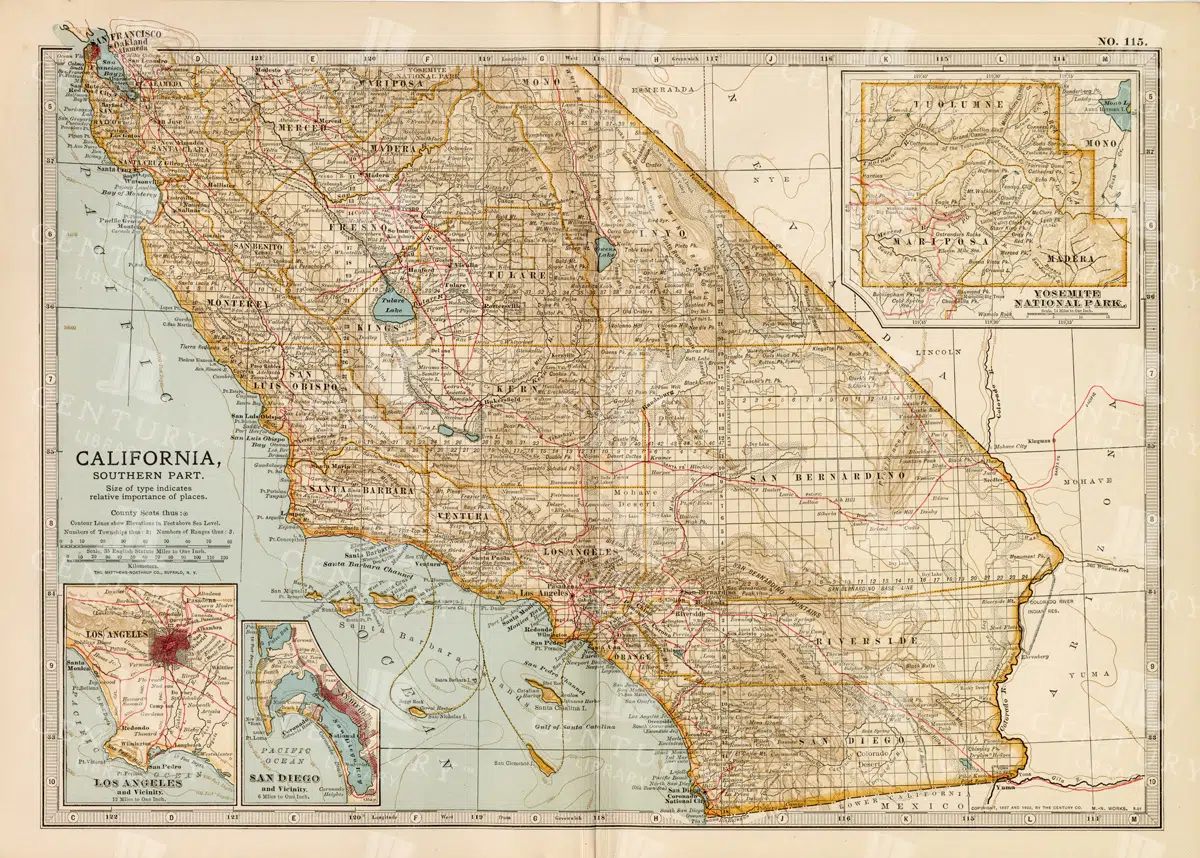
Vintage Map of Northern California Including San Francisco and Yosemite Valley
A vintage map depicting the northern part of California, highlighting major cities like San Francisco and natural landmarks such as Yosemite Valley. The map provides detailed insights into the region's geographical features, transportation routes, and historical importance.
- Resolution: 7113 x 5100
- Image Type(s): JPG
From this collection

Empire of Austria-Hungary Historical Map with Detailed Regional Boundaries and Railways
This historical map of the Austria-Hungary Empire showcases detailed regional boundaries, cities, and extensive railway networks. The map includes significant areas like Budapest and Vienna, providing a comprehensive view of the empire's geographical and political landscape during the period.
- Resolution: 7112 x 5100
- Image Type(s): JPG
From this collection

Antique Historical Map of Western Austria-Hungary Featuring Vienna and Prague
An antique map of the western part of Austria-Hungary, highlighting major cities like Vienna and Prague. The map provides intricate details of regional boundaries, railway networks, and topographical features, reflecting the historical political landscape of the region.
- Resolution: 7111 x 5100
- Image Type(s): JPG
From this collection

Antique 1800s Map of Arabia, Oman, and Aden Including the Arabian Peninsula – Vintage Historical Map
This antique map from the 1800s illustrates the Arabian Peninsula, including Arabia, Oman, and Aden. The vintage map highlights the region's historical geography, boundaries, and important cities, offering a detailed view of the area during the colonial period. A valuable resource for those interested in Middle Eastern history and cartography.
- Resolution: 7106 x 5100
- Image Type(s): JPG
From this collection

Vintage Design Element – Decorative Border / Frame Design No.28
- License Info
- Resolution: 1999px x 1414px
Related Images

Vintage Design Element – Decorative Border / Frame Design No.21
- License Info
- Resolution: 2579px x 2022px
Related Images
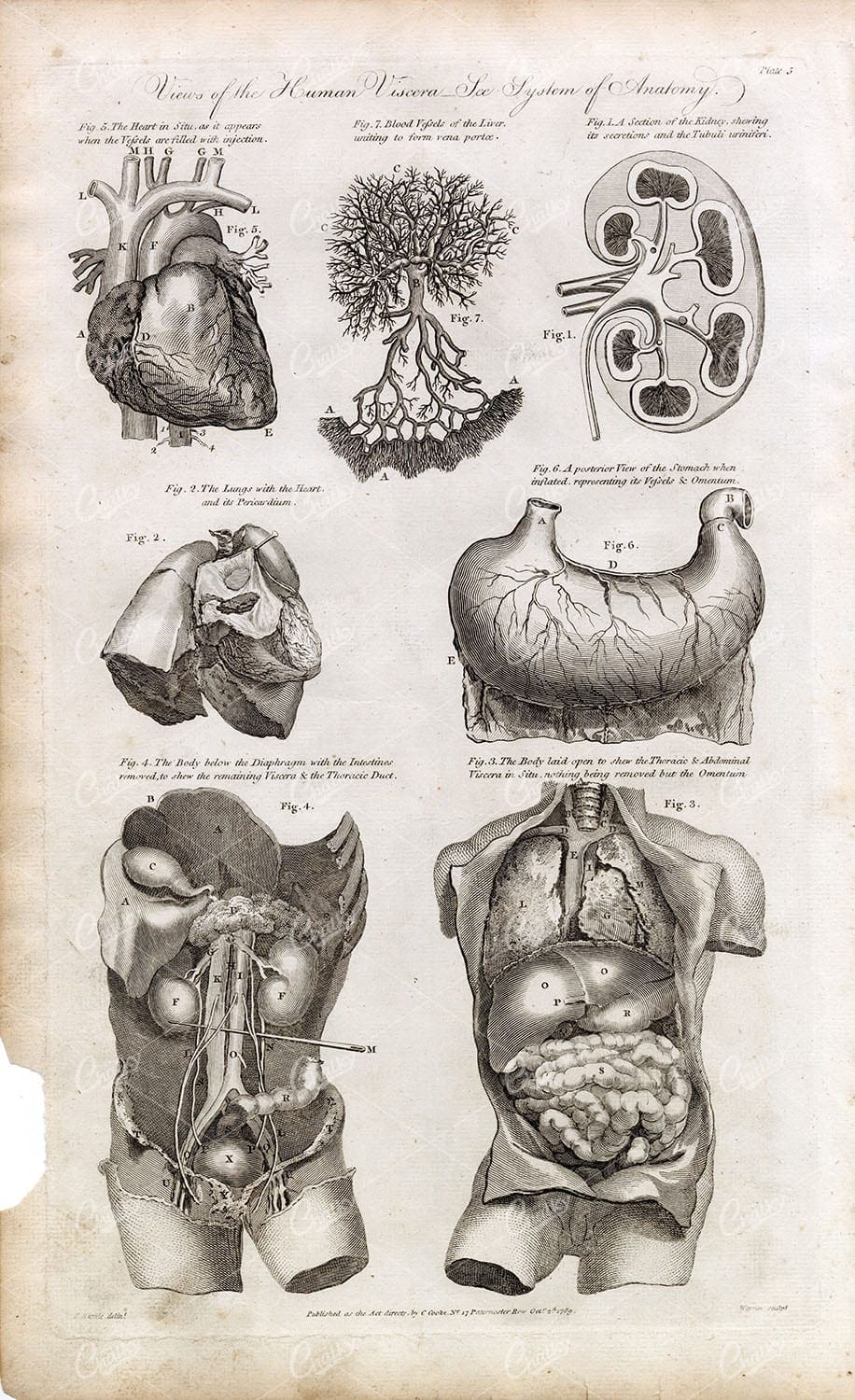
HUMAN ANATOMY – Viscera – Abdomen Organs (Heart, Liver, Intestines) 1791
You're looking at a scarce, 229 year old, steel plate engraving from the original "The New Encyclopaedia Or Modern Universal Dictionary Of Arts And Sciences On A New And Improved Plan" by Hall, William Henry, Bedford Row, London, published by C Cooke, London.
- License Info
- Resolution: 8300 x 13800 300dpi
- Year of Print: 1791
- Artist: C. Cooke
Related Images

Greek Mythological Scene Featuring Zeus and Winged Eros with Flowing Drapery
This image is part of our Extensive Collection of 135 Greek, Roman, and Mythology Vintage Line Art Illustrations. Each piece hand-selected from a variety of 19th-century books and ephemera found within our private library.
- Image Type(s): PNG
From this collection

Detailed 19th Century Map of Eastern Pennsylvania with Philadelphia Inset
A historic map from the 19th century depicting Eastern Pennsylvania, including detailed county lines, cities, and an inset of Philadelphia. This map captures the region's development and growth.
- Resolution: 7253 x 5100
- Image Type(s): JPG
From this collection

Antique 19th Century Map of Oregon Featuring Detailed Topographical Features
A detailed antique map from the 19th century showcasing the state of Oregon, including its mountains, rivers, and settlements. This map highlights the state's topography and early infrastructure development.
- Resolution: 7251 x 5100
- Image Type(s): JPG
From this collection

Antique Map of Maryland and Delaware with Washington D.C.
An antique map highlighting Maryland and Delaware, including insets of Washington D.C. and Baltimore, featuring roads, rivers, and county lines from the late 19th to early 20th century.
- Resolution: 7161 x 5100
- Image Type(s): JPG
- development
- early
- 20th
- administrative
- urbanization
- 19th
- late
- county
- dc
- century
- infrastructure
- boundaries
- colonial
- cartography
- transportation
- regional
- political
- landmarks
- historic
- heritage
- urban
- Roads
- vintage
- representation
- Lines
- Antique
- History
- Washington
- Delaware
- Baltimore
- Maryland
- Geography
- Atlas
- American
- City
- World
- Rivers
- Map
- Capital
From this collection

Antique 1800s Map of Arkansas with Detailed County Lines and Natural Features – Vintage Historical Cartography
An antique map from the 1800s showcasing Arkansas, with detailed county lines and natural features. This vintage map provides a historical view of Arkansas’s geography during the 19th century, offering a beautifully preserved piece of the state’s cartographic history.
- Resolution: 7108 x 5100
- Image Type(s): JPG
From this collection

GREEK Women Costume Fashion Hairstyles – 1888 Racinet Litho Print
- License Info
- Resolution: 7476 x 6558 300dpi
- Year of Print: 1888
Related Images

Mythological Depiction of Zeus with Eagle and Centaur Companion in Classical Lineart
This image is part of our Extensive Collection of 135 Greek, Roman, and Mythology Vintage Line Art Illustrations. Each piece hand-selected from a variety of 19th-century books and ephemera found within our private library.
- Image Type(s): PNG
From this collection

Antique Map of Washington State
Antique map of Washington State, featuring towns, counties, railroads, and geographical features such as rivers and mountains. 19th century cartography highlighting the development and infrastructure of the state.
- Resolution: 7278 x 5100
- Image Type(s): JPG
- nostalgic
- cartographer
- state boundaries
- washington state
- state development
- historical washington
- pacific northwest
- washington map
- northwest history
- washington geography
- reference
- archival
- geographical features
- USA
- infrastructure
- railroads
- detailed map
- historical map
- exploration
- old map
- cartography
- American history
- transportation
- counties
- towns
- education
- 19th-century
- collectible
- historical
- heritage
- classic
- vintage
- representation
- Antique
- History
- Washington
- Geography
- Atlas
- World
- Rivers
- Mountains
- Map
From this collection

19th Century Map of Switzerland, Liechtenstein, and Parts of Austria-Hungary
A detailed antique map from the 19th century showcasing Switzerland, Liechtenstein, and parts of Austria-Hungary. The map highlights the mountainous terrain, lakes, and major cities, reflecting the historical borders and settlements of the region.
- Resolution: 7267 x 5100
- Image Type(s): JPG
From this collection

Detailed 19th Century Map of Quebec, Canada with Historical Context
A richly detailed 19th century map of Quebec, Canada, showcasing various regions, cities, and geographical features. This historical map provides a glimpse into the past, reflecting the administrative and territorial divisions of the era. Insets highlight key areas, enhancing the map's informative value.
- Resolution: 7255 x 5100
- Image Type(s): JPG
- historical context
- Canadian history
- territorial divisions
- map insets
- archival
- historical document
- geography of Quebec
- Canadian provinces
- antique cartography
- St. Lawrence River
- historical records
- old Quebec
- history lovers
- historical artifact
- map of Canada
- historical information
- Quebec history
- antique paper
- educational tool
- detailed map
- regions
- topography
- cities
- historical geography
- antique map
- historical map
- old map
- cartography
- vintage map
- cartographic history
- 1800s
- 19th-century
- heritage
- country
- vintage
- representation
- Montreal
- Quebec
- Geography
- Atlas
- World
- Canada
- North America
- Map
From this collection

1897 Map of Kentucky Featuring Counties, Railways, and Rivers
This 1897 map of Kentucky highlights the state's counties, railways, and rivers, offering a detailed look at the region's geography and infrastructure during the late 19th century. The map serves as a valuable resource for understanding Kentucky's development, with a focus on transportation and regional divisions. The vintage cartography style enhances its historical significance.
- Resolution: 7157 x 5100
- Image Type(s): JPG
From this collection
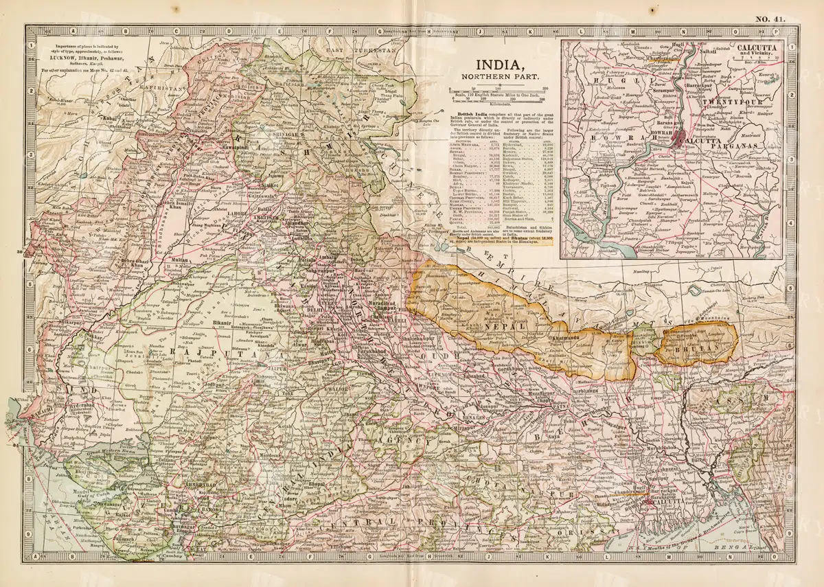
Historical Map of Northern India and Nepal Featuring Mountainous Terrain
Historical Map of Northern India and Nepal Featuring Mountainous Terrain
- Resolution: 7144 x 5100
- Image Type(s): JPG
- early 20th century
- Nepal
- Northern India
- Himalayas
- mountainous terrain
- South Asian history
- South Asia
- topography
- cities
- historical geography
- antique map
- historical map
- colonial
- exploration
- old map
- cartography
- political boundaries
- transportation
- historical
- old
- representation
- Antique
- History
- Geography
- Atlas
- World
- Landscape
- Globe
- Rivers
- Map
- Navigation
From this collection

Antique Map of the Chinese Empire Highlighting Major Regions and Cities
This antique map of the Chinese Empire highlights the major regions and cities, offering a detailed view of the empire's geographical and political structure. The map also includes insets of significant areas like Hong Kong and Peking, providing historical context.
- Resolution: 7119 x 5100
- Image Type(s): JPG
From this collection
Vintage Map of Southern California Featuring Los Angeles and San Diego
This vintage map showcases the southern part of California, including major cities like Los Angeles and San Diego. The map highlights important transportation routes, natural landmarks, and the region's historical and geographical features.
- Resolution: 7114 x 5100
- Image Type(s): JPG
From this collection

Vintage Decorative Line Art Illustration – Floral – Border – Frame – Pattern No.159
- License Info
- Resolution: 1868px x 4190px
Related Images

CUVIER 1820’s Antique Print. Horns of Stags, Muntjak
- License Info
- Resolution: 5065 x 8088 300dpi
- Year of Print: 1820
Related Images

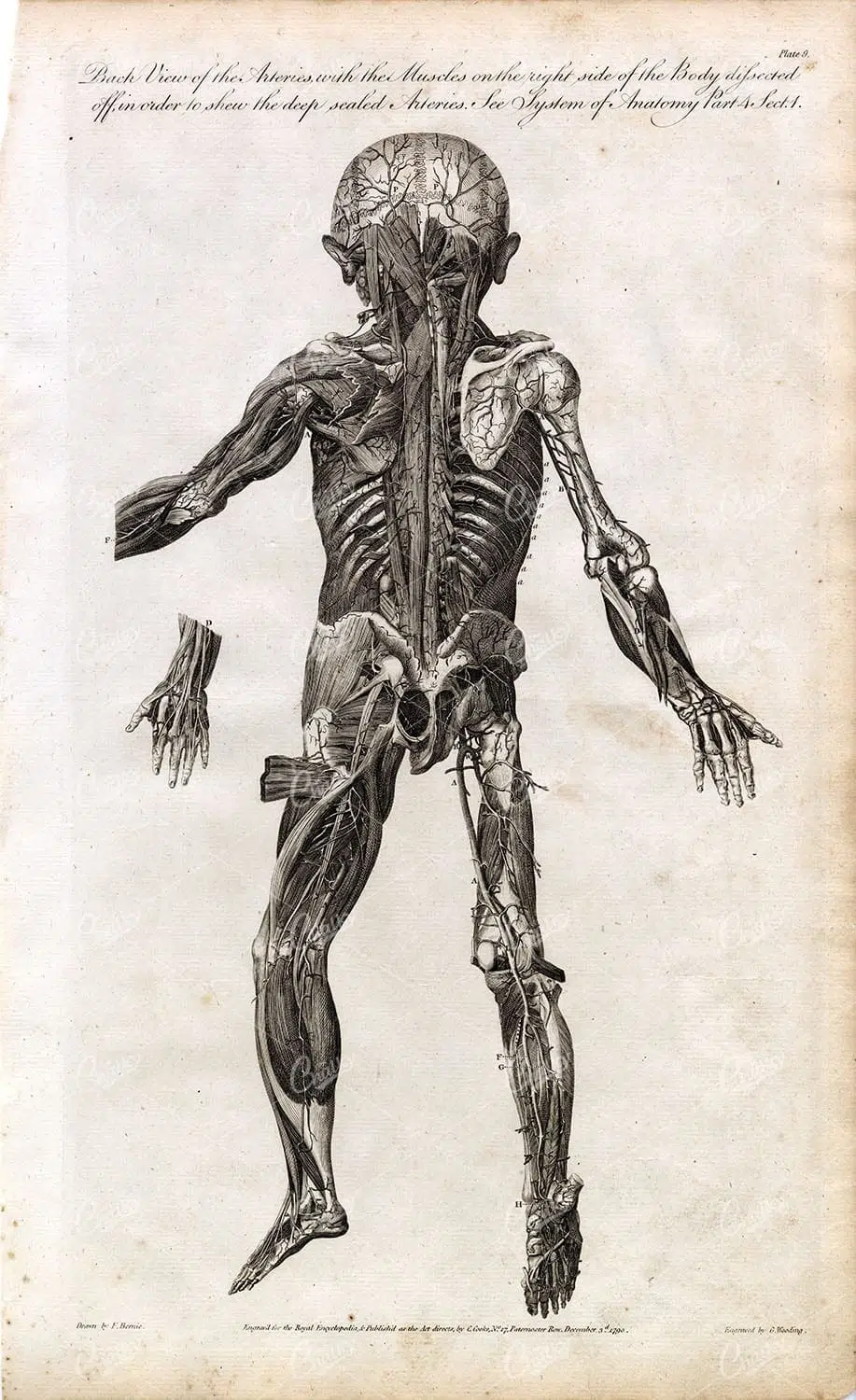
HUMAN ANATOMY – Back View of Arteries with Muscles Removed – Full Body
You're looking at a scarce, 229 year old, steel plate engraving from the original "The New Encyclopaedia Or Modern Universal Dictionary Of Arts And Sciences On A New And Improved Plan" by Hall, William Henry, Bedford Row, London, published by C Cooke, London.
- License Info
- Resolution: 8300 x 13800 300dpi
- Year of Print: 1791
- Artist: C. Cooke
Related Images

Detailed Antique Illustration of an Australian Sea-Horse with Unique Features
This vintage illustration from the 1800s depicts an Australian sea-horse, showcasing its intricate body structure and fins, typical of historical marine art.
- Resolution: 3251px x 2290px
- Image Type(s): PNG
Related Images

Detailed 19th Century Map of Illinois, USA
A richly detailed 19th century map of Illinois, focusing on the southern part of the state, including the area around Chicago and St. Louis. The map is intricately detailed with towns, railways, and geographical features, showcasing the state’s development during the period.
- Resolution: 7265 x 5100
- Image Type(s): JPG
- St. Louis
- southern Illinois
- archives
- reference
- territorial
- topographic
- USA
- development
- settlements
- Midwest
- topography
- antique map
- exploration
- old map
- cartography
- transportation
- railways
- counties
- landmarks
- towns
- historic
- 19th-century
- historical
- heritage
- urban
- country
- vintage
- retro
- representation
- Antique
- Rural
- History
- Chicago
- Illinois
- Geography
- Atlas
- World
- Engineering
- America
- Rivers
- Map
- Borders
From this collection

Antique 19th Century Map of Southern Ohio Featuring Major Cities and Rivers
A detailed 19th-century map showcasing Southern Ohio, highlighting cities like Cincinnati and Cleveland, along with rivers and other key geographical features. Ideal for historical and geographical studies.
- Resolution: 7248 x 5100
- Image Type(s): JPG
From this collection

Vintage Map of Montana
An antique map showcasing the state of Montana, highlighting counties, cities, and geographical features in fine detail, typical of late 19th to early 20th century cartography.
- Resolution: 7235 x 5100
- Image Type(s): JPG
From this collection

Vintage Map of Northern Illinois Featuring Chicago and Surrounding Areas
This vintage map of Northern Illinois features Chicago and its surrounding areas, highlighting major transportation routes, rivers, and urban centers. The map provides a detailed overview of the region's geography during the early 20th century, showcasing the development and expansion of Chicago as a key American city. It offers a historical perspective on the infrastructure and urban planning of the time.
- Resolution: 7142 x 5100
- Image Type(s): JPG
From this collection

Historical Map of Idaho and Wyoming Including Yellowstone National Park
This historical map covers the states of Idaho and Wyoming, with a special focus on Yellowstone National Park. The map details the topographical features, including mountains, rivers, and forests, as well as the transportation routes and political boundaries of the early 20th century. It provides a valuable snapshot of the American West during this period, highlighting the natural beauty and geographical diversity of the region.
- Resolution: 7141 x 5100
- Image Type(s): JPG
- early 20th century
- Yellowstone National Park
- Idaho
- Western states
- national parks
- forests
- topography
- historical geography
- antique map
- historical map
- exploration
- old map
- cartography
- American West
- political boundaries
- transportation
- conservation
- historical
- vintage
- old
- representation
- Antique
- History
- Wyoming
- Geography
- Landscape
- United States
- Rivers
- Mountains
- Map
From this collection
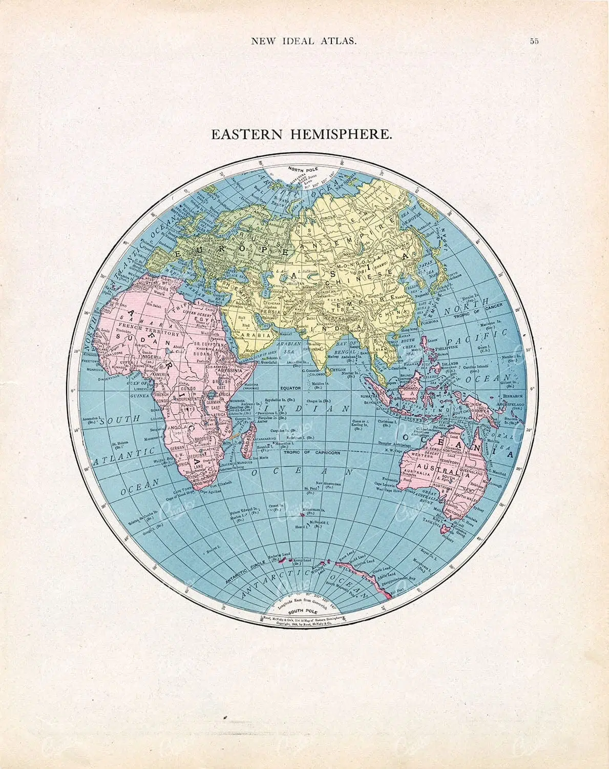
EASTERN Hemisphere Globe Map with North America on Rear
- License Info
- Resolution: 10000 x 12600 300dpi
- Artist: New Ideal Atlas
Related Images

19th Century Map of South Dakota with County Divisions
A detailed 19th century map of South Dakota, showcasing the state's counties, cities, and geographical features. This vintage map offers insight into the political and territorial divisions of the era, with intricate details of rivers and topography.
- Resolution: 7264 x 5100
- Image Type(s): JPG
- 1800s
- 19th-century
- American history
- antique cartography
- antique map
- antique paper
- archival
- cartographic history
- cartography
- cities
- county divisions
- geographical features
- Geography
- heritage
- historical artifact
- historical document
- historical geography
- historical information
- historical map
- historical records
- history lovers
- Map
- map of South Dakota
- old map
- old South Dakota
- Plan
- political divisions
- representation
- South Dakota
- state map
- territorial divisions
- topography
- United States
- vintage
- vintage map
From this collection

WORLD MAP – Rare Antique Fold Out Map – 1791 Cpt. Cook Discoveries
You're looking at a scarce, 229 year old, steel plate engraving from the original "The New Encyclopaedia Or Modern Universal Dictionary Of Arts And Sciences On A New And Improved Plan" by Hall, William Henry, Bedford Row, London, published by C Cooke, London.
- License Info
- Resolution: 16700 x 13600 300dpi
- Year of Print: 1791
- Artist: C. Cooke
Related Images
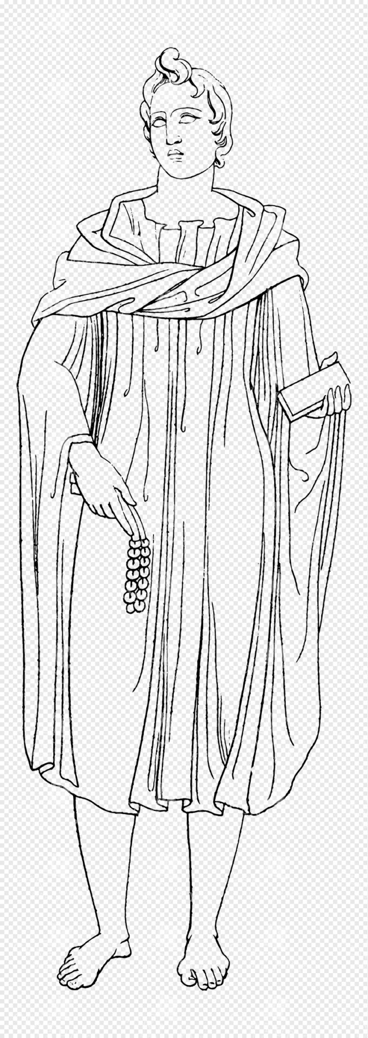
Greek Mythology Lineart Illustration Holding Grapes and Scroll in Robes
This image is part of our Extensive Collection of 135 Greek, Roman, and Mythology Vintage Line Art Illustrations. Each piece hand-selected from a variety of 19th-century books and ephemera found within our private library.
- Image Type(s): PNG
From this collection

Goldfinches and Nest Illustration on Transparent Background
Illustration of goldfinches at their nest, with intricate details of the birds and surrounding foliage, isolated on a transparent background.
- Resolution: 4507px x 5279px
- Image Type(s): PNG
- Animal
- Art
- avian
- Birds
- Birdwatching
- Black and white
- Breeding
- Decorative
- detailed
- distinctive
- Drawing
- Eggs
- Family
- Feathers
- Foliage
- Garden
- Goldfinches
- Identification
- illustration
- isolated
- Natural History
- Nature
- Nest
- Nesting
- Observation
- Ornate
- Ornithological
- ornithology
- Perch
- perched
- plumage
- PNG
- representation
- sketch
- Songbirds
- species
- transparent background
- Wildlife
- Wing
Related Images
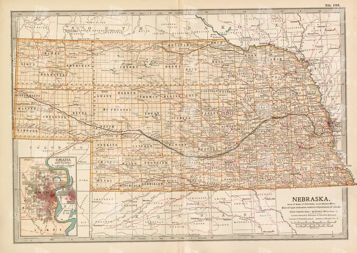
Historic Map of Nebraska
A detailed historic map of Nebraska, illustrating counties, towns, and important routes, reflecting the geography and infrastructure of the state during the late 19th to early 20th century.
- Resolution: 7236 x 5100
- Image Type(s): JPG
From this collection

VINTAGE Greek Female Costume Print – Antique 1883
- Resolution: 4420px x 6320px
Related Images

ANTIQUE 1883 Costume Print – Priestess of Demeter
- Resolution: 4472px x 6320px
Related Images

Old Line Art Illustration of a Knight Riding a Horse No.9
- License Info
- Resolution: 2155px x 2672px
Related Images

ANATOMY – Antique Human Myology Print – Rare Full Body Engraving 1791
You're looking at a scarce, 229 year old, steel plate engraving from the original "The New Encyclopaedia Or Modern Universal Dictionary Of Arts And Sciences On A New And Improved Plan" by Hall, William Henry, Bedford Row, London, published by C Cooke, London.
- License Info
- Resolution: 8300 x 13800 300dpi
- Year of Print: 1791
- Artist: C. Cooke
Related Images
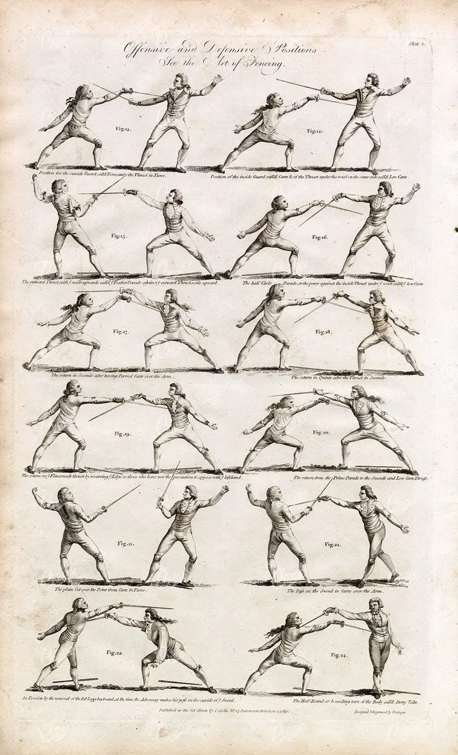
1791 FENCING Stances – Offensive and Defensive Positions – Antique Print
You're looking at a scarce, 229 year old, steel plate engraving from the original "The New Encyclopaedia Or Modern Universal Dictionary Of Arts And Sciences On A New And Improved Plan" by Hall, William Henry, Bedford Row, London, published by C Cooke, London.
- License Info
- Resolution: 8300 x 13800 300dpi
- Year of Print: 1791
- Artist: C. Cooke
Related Images

Antique Map of North Dakota
A historic map of North Dakota from the late 19th century, detailing the state's counties, cities, and major geographical landmarks, reflecting its development and settlement patterns.
- Resolution: 7244 x 5100
- Image Type(s): JPG
From this collection

Vintage Christmas Line Art Illustration – Robins in a Tree and Bird House Corner Piece
- License Info
- Resolution: 1457px x 1555px
Related Images

Support the Library
Our supporters and members help us continue collecting and restoring these wonderful pieces of art for the modern creator
Unlock Everything and Become a Member!
While a lot of the library is available for free, some is kept behind closed dusty doors only to be accessed by our lovely members.